Note:
The expiration time in the watch graphic is amended if the watch is
replaced, cancelled or extended.
Note:
Note:
The expiration time in the watch graphic is amended if the watch is
replaced, cancelled or extended.
Note: Click for
Watch Status Reports.
SEL3
URGENT - IMMEDIATE BROADCAST REQUESTED
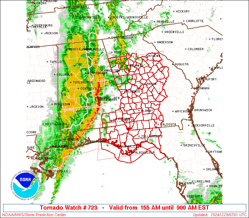
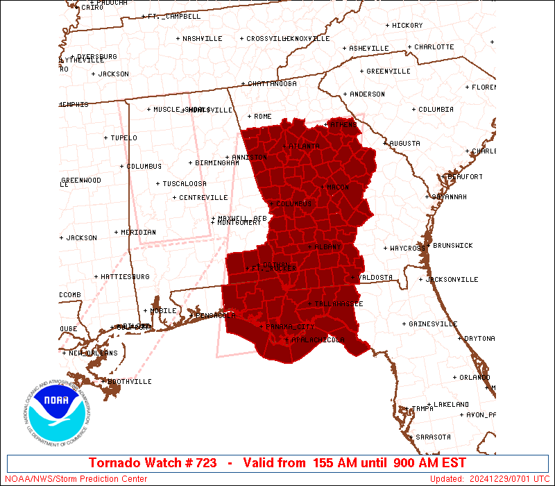
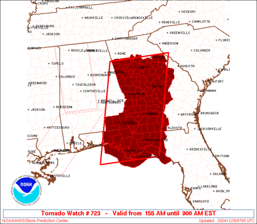
Tornado Watch Number 723
NWS Storm Prediction Center Norman OK
155 AM EST Sun Dec 29 2024
The NWS Storm Prediction Center has issued a
* Tornado Watch for portions of
Southeastern Alabama
Florida Panhandle to Big Bend
Georgia
Coastal Waters
* Effective this Sunday morning from 155 AM until 900 AM EST.
* Primary threats include...
A few tornadoes possible
Scattered damaging wind gusts to 70 mph possible
SUMMARY...A line of strong-severe thunderstorms will continue to
move through an environment characterized by modest instability but
favorable shear, and may produce occasional embedded tornadoes
and/or damaging nontornadic winds.
The tornado watch area is approximately along and 90 statute miles
east and west of a line from 15 miles southwest of Apalachicola FL
to 40 miles northeast of Atlanta GA. For a complete depiction of the
watch see the associated watch outline update (WOUS64 KWNS WOU3).
PRECAUTIONARY/PREPAREDNESS ACTIONS...
REMEMBER...A Tornado Watch means conditions are favorable for
tornadoes and severe thunderstorms in and close to the watch
area. Persons in these areas should be on the lookout for
threatening weather conditions and listen for later statements
and possible warnings.
&&
OTHER WATCH INFORMATION...CONTINUE...WW 721...WW 722...
AVIATION...Tornadoes and a few severe thunderstorms with hail
surface and aloft to 1 inch. Extreme turbulence and surface wind
gusts to 60 knots. A few cumulonimbi with maximum tops to 500. Mean
storm motion vector 24030.
...Edwards

   SEL3

   URGENT - IMMEDIATE BROADCAST REQUESTED
   Tornado Watch Number 723
   NWS Storm Prediction Center Norman OK
   155 AM EST Sun Dec 29 2024

   The NWS Storm Prediction Center has issued a

   * Tornado Watch for portions of
     Southeastern Alabama
     Florida Panhandle to Big Bend
     Georgia
     Coastal Waters

   * Effective this Sunday morning from 155 AM until 900 AM EST.

   * Primary threats include...
     A few tornadoes possible
     Scattered damaging wind gusts to 70 mph possible

   SUMMARY...A line of strong-severe thunderstorms will continue to
   move through an environment characterized by modest instability but
   favorable shear, and may produce occasional embedded tornadoes
   and/or damaging nontornadic winds.

   The tornado watch area is approximately along and 90 statute miles
   east and west of a line from 15 miles southwest of Apalachicola FL
   to 40 miles northeast of Atlanta GA. For a complete depiction of the
   watch see the associated watch outline update (WOUS64 KWNS WOU3).

   PRECAUTIONARY/PREPAREDNESS ACTIONS...

   REMEMBER...A Tornado Watch means conditions are favorable for
   tornadoes and severe thunderstorms in and close to the watch
   area. Persons in these areas should be on the lookout for
   threatening weather conditions and listen for later statements
   and possible warnings.

   &&

   OTHER WATCH INFORMATION...CONTINUE...WW 721...WW 722...

   AVIATION...Tornadoes and a few severe thunderstorms with hail
   surface and aloft to 1 inch. Extreme turbulence and surface wind
   gusts to 60 knots. A few cumulonimbi with maximum tops to 500. Mean
   storm motion vector 24030.

   ...Edwards
 Note:
The Aviation Watch (SAW) product is an approximation to the watch area.
The actual watch is depicted by the shaded areas.
Note:
The Aviation Watch (SAW) product is an approximation to the watch area.
The actual watch is depicted by the shaded areas.
   SAW3
   WW 723 TORNADO AL FL GA CW 290655Z - 291400Z
   AXIS..90 STATUTE MILES EAST AND WEST OF LINE..
   15SW AAF/APALACHICOLA FL/ - 40NE ATL/ATLANTA GA/
   ..AVIATION COORDS.. 80NM E/W /73SW TLH - 35NE ATL/
   HAIL SURFACE AND ALOFT..1 INCH. WIND GUSTS..60 KNOTS.
   MAX TOPS TO 500. MEAN STORM MOTION VECTOR 24030.

   LAT...LON 29578670 34038551 34038236 29578371

   THIS IS AN APPROXIMATION TO THE WATCH AREA.  FOR A
   COMPLETE DEPICTION OF THE WATCH SEE WOUS64 KWNS
   FOR WOU3.
Watch 723 Status Report Messages:
STATUS REPORT #4 ON WW 723
VALID 291145Z - 291240Z
SEVERE WEATHER THREAT CONTINUES RIGHT OF A LINE FROM 55 SW PFN TO
25 WSW MAI TO 45 NE ABY TO 50 SSE AHN TO 15 ENE AHN.
..GRAMS..12/29/24
ATTN...WFO...TAE...FFC...
&&
STATUS REPORT FOR WT 723
SEVERE WEATHER THREAT CONTINUES FOR THE FOLLOWING AREAS
FLC005-013-037-039-045-063-065-073-077-079-123-129-133-291240-
FL
. FLORIDA COUNTIES INCLUDED ARE
BAY CALHOUN FRANKLIN
GADSDEN GULF JACKSON
JEFFERSON LEON LIBERTY
MADISON TAYLOR WAKULLA
WASHINGTON
$$
GAC017-019-023-027-071-075-087-091-107-125-131-141-155-163-167-
173-175-185-205-209-235-253-265-271-275-277-279-283-287-301-303-
309-315-317-319-321-291240-
GA
. GEORGIA COUNTIES INCLUDED ARE
BEN HILL BERRIEN BLECKLEY
BROOKS COLQUITT COOK
DECATUR DODGE EMANUEL
GLASCOCK GRADY HANCOCK
IRWIN JEFFERSON JOHNSON
LANIER LAURENS LOWNDES
MITCHELL MONTGOMERY PULASKI
SEMINOLE TALIAFERRO TELFAIR
THOMAS TIFT TOOMBS
TREUTLEN TURNER WARREN
WASHINGTON WHEELER WILCOX
WILKES WILKINSON WORTH
$$
GMZ730-750-752-755-765-291240-
CW
. ADJACENT COASTAL WATERS INCLUDED ARE
APALACHEE BAY OR COASTAL WATERS FROM KEATON BEACH TO OCHLOCKONEE
RIVER FL OUT TO 20 NM
COASTAL WATERS FROM OKALOOSA-WALTON COUNTY LINE TO MEXICO BEACH
OUT 20 NM
COASTAL WATERS FROM MEXICO BEACH TO APALACHICOLA OUT 20 NM
COASTAL WATERS FROM OCHLOCKONEE RIVER TO APALACHICOLA FL OUT TO
20 NM
COASTAL WATERS FROM SUWANNEE RIVER TO KEATON BEACH OUT 20 NM
$$
THE WATCH STATUS MESSAGE IS FOR GUIDANCE PURPOSES ONLY. PLEASE
REFER TO WATCH COUNTY NOTIFICATION STATEMENTS FOR OFFICIAL
INFORMATION ON COUNTIES...INDEPENDENT CITIES AND MARINE ZONES
CLEARED FROM SEVERE THUNDERSTORM AND TORNADO WATCHES.
$$
STATUS REPORT #3 ON WW 723
VALID 291030Z - 291140Z
SEVERE WEATHER THREAT CONTINUES RIGHT OF A LINE FROM 45 SE PNS TO
25 NW ABY TO 25 NNW MCN TO 30 NNE ATL.
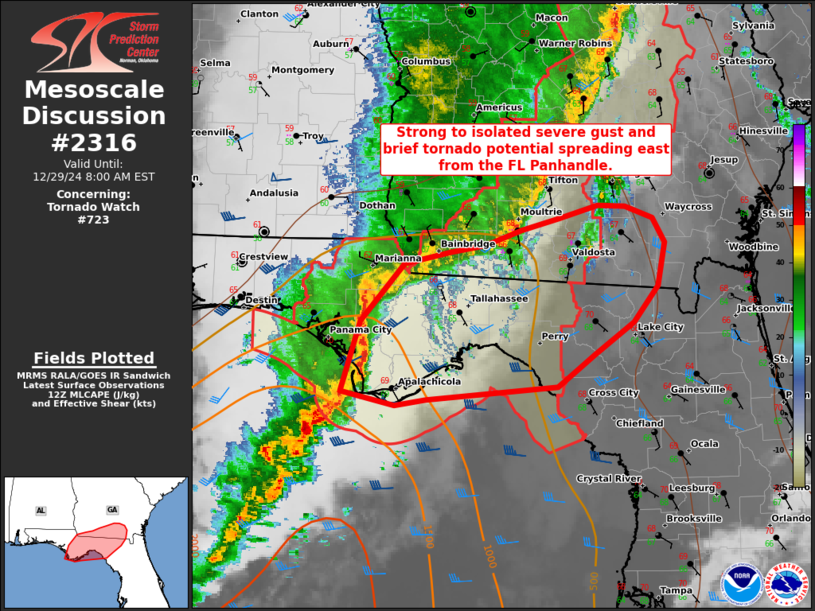
FOR ADDITIONAL INFORMATION SEE MESOSCALE DISCUSSION 2315.
..GRAMS..12/29/24
ATTN...WFO...TAE...FFC...
&&
STATUS REPORT FOR WT 723
SEVERE WEATHER THREAT CONTINUES FOR THE FOLLOWING AREAS
ALC069-291140-
AL
. ALABAMA COUNTIES INCLUDED ARE
HOUSTON
$$
FLC005-013-037-039-045-063-065-073-077-079-123-129-133-291140-
FL
. FLORIDA COUNTIES INCLUDED ARE
BAY CALHOUN FRANKLIN
GADSDEN GULF JACKSON
JEFFERSON LEON LIBERTY
MADISON TAYLOR WAKULLA
WASHINGTON
$$
GAC007-009-017-019-021-023-027-037-071-075-079-081-087-091-093-
095-099-125-131-133-135-141-153-155-159-163-167-169-173-175-177-
185-193-201-205-207-211-217-219-221-225-235-237-247-253-261-265-
271-273-275-277-287-289-297-301-303-309-315-317-319-321-
291140-
GA
. GEORGIA COUNTIES INCLUDED ARE
BAKER BALDWIN BEN HILL
BERRIEN BIBB BLECKLEY
BROOKS CALHOUN COLQUITT
COOK CRAWFORD CRISP
DECATUR DODGE DOOLY
DOUGHERTY EARLY GLASCOCK
GRADY GREENE GWINNETT
HANCOCK HOUSTON IRWIN
JASPER JEFFERSON JOHNSON
JONES LANIER LAURENS
LEE LOWNDES MACON
MILLER MITCHELL MONROE
MORGAN NEWTON OCONEE
OGLETHORPE PEACH PULASKI
PUTNAM ROCKDALE SEMINOLE
SUMTER TALIAFERRO TELFAIR
TERRELL THOMAS TIFT
TURNER TWIGGS WALTON
WARREN WASHINGTON WHEELER
WILCOX WILKES WILKINSON
WORTH
$$
GMZ730-750-752-755-765-291140-
CW
. ADJACENT COASTAL WATERS INCLUDED ARE
APALACHEE BAY OR COASTAL WATERS FROM KEATON BEACH TO OCHLOCKONEE
RIVER FL OUT TO 20 NM
COASTAL WATERS FROM OKALOOSA-WALTON COUNTY LINE TO MEXICO BEACH
OUT 20 NM
COASTAL WATERS FROM MEXICO BEACH TO APALACHICOLA OUT 20 NM
COASTAL WATERS FROM OCHLOCKONEE RIVER TO APALACHICOLA FL OUT TO
20 NM
COASTAL WATERS FROM SUWANNEE RIVER TO KEATON BEACH OUT 20 NM
$$
THE WATCH STATUS MESSAGE IS FOR GUIDANCE PURPOSES ONLY. PLEASE
REFER TO WATCH COUNTY NOTIFICATION STATEMENTS FOR OFFICIAL
INFORMATION ON COUNTIES...INDEPENDENT CITIES AND MARINE ZONES
CLEARED FROM SEVERE THUNDERSTORM AND TORNADO WATCHES.
$$
STATUS REPORT #2 ON WW 723
VALID 290945Z - 291040Z
SEVERE WEATHER THREAT CONTINUES RIGHT OF A LINE FROM 15 NE CEW TO
30 SSE CSG TO 35 ENE LGC TO 35 NNW ATL.
FOR ADDITIONAL INFORMATION SEE MESOSCALE DISCUSSION 2314.
..GRAMS..12/29/24
ATTN...WFO...TAE...FFC...
&&
STATUS REPORT FOR WT 723
SEVERE WEATHER THREAT CONTINUES FOR THE FOLLOWING AREAS
ALC061-067-069-291040-
AL
. ALABAMA COUNTIES INCLUDED ARE
GENEVA HENRY HOUSTON
$$
FLC005-013-037-039-045-059-063-065-073-077-079-123-129-131-133-
291040-
FL
. FLORIDA COUNTIES INCLUDED ARE
BAY CALHOUN FRANKLIN
GADSDEN GULF HOLMES
JACKSON JEFFERSON LEON
LIBERTY MADISON TAYLOR
WAKULLA WALTON WASHINGTON
$$
GAC007-009-017-019-021-023-027-035-037-061-063-067-071-075-079-
081-087-089-091-093-095-099-113-121-125-131-133-135-141-151-153-
155-159-163-167-169-171-173-175-177-185-193-197-201-205-207-211-
217-219-221-225-231-235-237-243-247-249-253-255-261-263-265-269-
271-273-275-277-287-289-293-297-301-303-307-309-315-317-319-321-
291040-
GA
. GEORGIA COUNTIES INCLUDED ARE
BAKER BALDWIN BEN HILL
BERRIEN BIBB BLECKLEY
BROOKS BUTTS CALHOUN
CLAY CLAYTON COBB
COLQUITT COOK CRAWFORD
CRISP DECATUR DEKALB
DODGE DOOLY DOUGHERTY
EARLY FAYETTE FULTON
GLASCOCK GRADY GREENE
GWINNETT HANCOCK HENRY
HOUSTON IRWIN JASPER
JEFFERSON JOHNSON JONES
LAMAR LANIER LAURENS
LEE LOWNDES MACON
MARION MILLER MITCHELL
MONROE MORGAN NEWTON
OCONEE OGLETHORPE PEACH
PIKE PULASKI PUTNAM
RANDOLPH ROCKDALE SCHLEY
SEMINOLE SPALDING SUMTER
TALBOT TALIAFERRO TAYLOR
TELFAIR TERRELL THOMAS
TIFT TURNER TWIGGS
UPSON WALTON WARREN
WASHINGTON WEBSTER WHEELER
WILCOX WILKES WILKINSON
WORTH
$$
GMZ730-750-752-755-765-291040-
CW
. ADJACENT COASTAL WATERS INCLUDED ARE
APALACHEE BAY OR COASTAL WATERS FROM KEATON BEACH TO OCHLOCKONEE
RIVER FL OUT TO 20 NM
COASTAL WATERS FROM OKALOOSA-WALTON COUNTY LINE TO MEXICO BEACH
OUT 20 NM
COASTAL WATERS FROM MEXICO BEACH TO APALACHICOLA OUT 20 NM
COASTAL WATERS FROM OCHLOCKONEE RIVER TO APALACHICOLA FL OUT TO
20 NM
COASTAL WATERS FROM SUWANNEE RIVER TO KEATON BEACH OUT 20 NM
$$
THE WATCH STATUS MESSAGE IS FOR GUIDANCE PURPOSES ONLY. PLEASE
REFER TO WATCH COUNTY NOTIFICATION STATEMENTS FOR OFFICIAL
INFORMATION ON COUNTIES...INDEPENDENT CITIES AND MARINE ZONES
CLEARED FROM SEVERE THUNDERSTORM AND TORNADO WATCHES.
$$
STATUS REPORT #1 ON WW 723
VALID 290830Z - 290940Z
SEVERE WEATHER THREAT CONTINUES RIGHT OF A LINE FROM 30 SSW TOI
TO 5 SW AUO TO 25 SSW RMG.
..GRAMS..12/29/24
ATTN...WFO...TAE...FFC...
&&
STATUS REPORT FOR WT 723
SEVERE WEATHER THREAT CONTINUES FOR THE FOLLOWING AREAS
ALC031-045-061-067-069-290940-
AL
. ALABAMA COUNTIES INCLUDED ARE
COFFEE DALE GENEVA
HENRY HOUSTON
$$
FLC005-013-037-039-045-059-063-065-073-077-079-123-129-131-133-
290940-
FL
. FLORIDA COUNTIES INCLUDED ARE
BAY CALHOUN FRANKLIN
GADSDEN GULF HOLMES
JACKSON JEFFERSON LEON
LIBERTY MADISON TAYLOR
WAKULLA WALTON WASHINGTON
$$
GAC007-009-017-019-021-023-027-035-037-045-053-061-063-067-071-
075-077-079-081-087-089-091-093-095-097-099-113-121-125-131-133-
135-141-143-145-149-151-153-155-159-163-167-169-171-173-175-177-
185-193-197-199-201-205-207-211-215-217-219-221-223-225-231-233-
235-237-239-243-247-249-253-255-259-261-263-265-269-271-273-275-
277-285-287-289-293-297-301-303-307-309-315-317-319-321-
290940-
GA
. GEORGIA COUNTIES INCLUDED ARE
BAKER BALDWIN BEN HILL
BERRIEN BIBB BLECKLEY
BROOKS BUTTS CALHOUN
CARROLL CHATTAHOOCHEE CLAY
CLAYTON COBB COLQUITT
COOK COWETA CRAWFORD
CRISP DECATUR DEKALB
DODGE DOOLY DOUGHERTY
DOUGLAS EARLY FAYETTE
FULTON GLASCOCK GRADY
GREENE GWINNETT HANCOCK
HARALSON HARRIS HEARD
HENRY HOUSTON IRWIN
JASPER JEFFERSON JOHNSON
JONES LAMAR LANIER
LAURENS LEE LOWNDES
MACON MARION MERIWETHER
MILLER MITCHELL MONROE
MORGAN MUSCOGEE NEWTON
OCONEE OGLETHORPE PAULDING
PEACH PIKE POLK
PULASKI PUTNAM QUITMAN
RANDOLPH ROCKDALE SCHLEY
SEMINOLE SPALDING STEWART
SUMTER TALBOT TALIAFERRO
TAYLOR TELFAIR TERRELL
THOMAS TIFT TROUP
TURNER TWIGGS UPSON
WALTON WARREN WASHINGTON
WEBSTER WHEELER WILCOX
WILKES WILKINSON WORTH
$$
GMZ730-750-752-755-765-290940-
CW
. ADJACENT COASTAL WATERS INCLUDED ARE
APALACHEE BAY OR COASTAL WATERS FROM KEATON BEACH TO OCHLOCKONEE
RIVER FL OUT TO 20 NM
COASTAL WATERS FROM OKALOOSA-WALTON COUNTY LINE TO MEXICO BEACH
OUT 20 NM
COASTAL WATERS FROM MEXICO BEACH TO APALACHICOLA OUT 20 NM
COASTAL WATERS FROM OCHLOCKONEE RIVER TO APALACHICOLA FL OUT TO
20 NM
COASTAL WATERS FROM SUWANNEE RIVER TO KEATON BEACH OUT 20 NM
$$
THE WATCH STATUS MESSAGE IS FOR GUIDANCE PURPOSES ONLY. PLEASE
REFER TO WATCH COUNTY NOTIFICATION STATEMENTS FOR OFFICIAL
INFORMATION ON COUNTIES...INDEPENDENT CITIES AND MARINE ZONES
CLEARED FROM SEVERE THUNDERSTORM AND TORNADO WATCHES.
$$
Note:
Click for Complete Product Text.
Tornadoes
Probability of 2 or more tornadoes
|
Mod (50%)
|
Probability of 1 or more strong (EF2-EF5) tornadoes
|
Low (20%)
|
Wind
Probability of 10 or more severe wind events
|
Mod (40%)
|
Probability of 1 or more wind events > 65 knots
|
Low (20%)
|
Hail
Probability of 10 or more severe hail events
|
Low (10%)
|
Probability of 1 or more hailstones > 2 inches
|
Low (<5%)
|
Combined Severe Hail/Wind
Probability of 6 or more combined severe hail/wind events
|
Mod (60%)
|
For each watch, probabilities for particular events inside the watch
(listed above in each table) are determined by the issuing forecaster.
The "Low" category contains probability values ranging from less than 2%
to 20% (EF2-EF5 tornadoes), less than 5% to 20% (all other probabilities),
"Moderate" from 30% to 60%, and "High" from 70% to greater than 95%.
High values are bolded and lighter in color to provide awareness of
an increased threat for a particular event.


 @NWSSPC