Note:
The expiration time in the watch graphic is amended if the watch is
replaced, cancelled or extended.
Note:
Note:
The expiration time in the watch graphic is amended if the watch is
replaced, cancelled or extended.
Note: Click for
Watch Status Reports.
SEL4
URGENT - IMMEDIATE BROADCAST REQUESTED
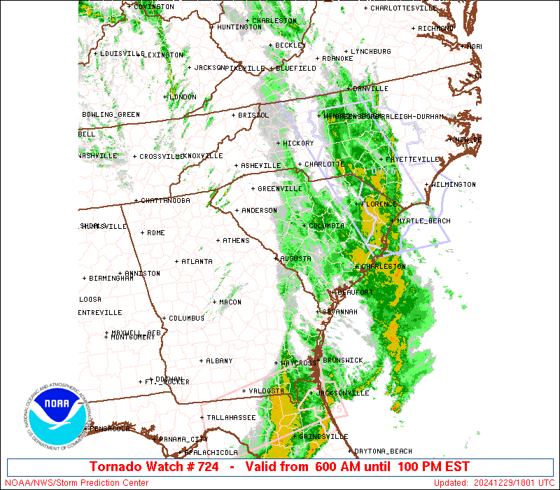
Tornado Watch Number 724
NWS Storm Prediction Center Norman OK
600 AM EST Sun Dec 29 2024
The NWS Storm Prediction Center has issued a
* Tornado Watch for portions of
Eastern Georgia
Southwestern North Carolina
South Carolina
Coastal Waters
* Effective this Sunday morning and afternoon from 600 AM until
100 PM EST.
* Primary threats include...
A few tornadoes possible
Scattered damaging wind gusts to 70 mph possible
SUMMARY...The faster-moving northern part of a line of strong-severe
thunderstorms will move northeastward across the watch area thriough
midday, offering sporadic damaging to severe gusts and potential for
a few embedded tornadoes.
The tornado watch area is approximately along and 80 statute miles
either side of a line from 35 miles east southeast of Savannah GA to
45 miles north of Greenville SC. For a complete depiction of the
watch see the associated watch outline update (WOUS64 KWNS WOU4).
PRECAUTIONARY/PREPAREDNESS ACTIONS...
REMEMBER...A Tornado Watch means conditions are favorable for
tornadoes and severe thunderstorms in and close to the watch
area. Persons in these areas should be on the lookout for
threatening weather conditions and listen for later statements
and possible warnings.
&&
OTHER WATCH INFORMATION...CONTINUE...WW 723...
AVIATION...Tornadoes and a few severe thunderstorms with hail
surface and aloft to 1 inch. Extreme turbulence and surface wind
gusts to 60 knots. A few cumulonimbi with maximum tops to 450. Mean
storm motion vector 23040.
...Edwards

   SEL4

   URGENT - IMMEDIATE BROADCAST REQUESTED
   Tornado Watch Number 724
   NWS Storm Prediction Center Norman OK
   600 AM EST Sun Dec 29 2024

   The NWS Storm Prediction Center has issued a

   * Tornado Watch for portions of
     Eastern Georgia
     Southwestern North Carolina
     South Carolina
     Coastal Waters

   * Effective this Sunday morning and afternoon from 600 AM until
     100 PM EST.

   * Primary threats include...
     A few tornadoes possible
     Scattered damaging wind gusts to 70 mph possible

   SUMMARY...The faster-moving northern part of a line of strong-severe
   thunderstorms will move northeastward across the watch area thriough
   midday, offering sporadic damaging to severe gusts and potential for
   a few embedded tornadoes.

   The tornado watch area is approximately along and 80 statute miles
   either side of a line from 35 miles east southeast of Savannah GA to
   45 miles north of Greenville SC. For a complete depiction of the
   watch see the associated watch outline update (WOUS64 KWNS WOU4).

   PRECAUTIONARY/PREPAREDNESS ACTIONS...

   REMEMBER...A Tornado Watch means conditions are favorable for
   tornadoes and severe thunderstorms in and close to the watch
   area. Persons in these areas should be on the lookout for
   threatening weather conditions and listen for later statements
   and possible warnings.

   &&

   OTHER WATCH INFORMATION...CONTINUE...WW 723...

   AVIATION...Tornadoes and a few severe thunderstorms with hail
   surface and aloft to 1 inch. Extreme turbulence and surface wind
   gusts to 60 knots. A few cumulonimbi with maximum tops to 450. Mean
   storm motion vector 23040.

   ...Edwards
 Note:
The Aviation Watch (SAW) product is an approximation to the watch area.
The actual watch is depicted by the shaded areas.
Note:
The Aviation Watch (SAW) product is an approximation to the watch area.
The actual watch is depicted by the shaded areas.
   SAW4
   WW 724 TORNADO GA NC SC CW 291100Z - 291800Z
   AXIS..80 STATUTE MILES EITHER SIDE OF LINE..
   35ESE SAV/SAVANNAH GA/ - 45N GSP/GREENVILLE SC/
   ..AVIATION COORDS.. 70NM EITHER SIDE /27ESE SAV - 34NNW SPA/
   HAIL SURFACE AND ALOFT..1 INCH. WIND GUSTS..60 KNOTS.
   MAX TOPS TO 450. MEAN STORM MOTION VECTOR 23040.

   LAT...LON 31468189 35078351 36028091 32407940

   THIS IS AN APPROXIMATION TO THE WATCH AREA.  FOR A
   COMPLETE DEPICTION OF THE WATCH SEE WOUS64 KWNS
   FOR WOU4.
Watch 724 Status Report Messages:
STATUS REPORT #4 ON WW 724
VALID 291640Z - 291740Z
SEVERE WEATHER THREAT CONTINUES RIGHT OF A LINE FROM 55 ESE SAV
TO 40 NNE CHS.
..HART..12/29/24
ATTN...WFO...CHS...CAE...GSP...
&&
STATUS REPORT FOR WT 724
SEVERE WEATHER THREAT CONTINUES FOR THE FOLLOWING AREAS
AMZ350-370-372-374-291740-
CW
. ADJACENT COASTAL WATERS INCLUDED ARE
COASTAL WATERS FROM SOUTH SANTEE RIVER TO EDISTO BEACH SC OUT 20
NM
WATERS FROM SOUTH SANTEE RIVER SC TO EDISTO BEACH SC EXTENDING
FROM 20 NM TO 40 NM
WATERS FROM EDISTO BEACH SC TO SAVANNAH GA EXTENDING FROM 20 NM
TO 40 NM
WATERS FROM SAVANNAH GA TO ALTAMAHA SOUND GA EXTENDING FROM 20 NM
TO 60 NM
$$
THE WATCH STATUS MESSAGE IS FOR GUIDANCE PURPOSES ONLY. PLEASE
REFER TO WATCH COUNTY NOTIFICATION STATEMENTS FOR OFFICIAL
INFORMATION ON COUNTIES...INDEPENDENT CITIES AND MARINE ZONES
CLEARED FROM SEVERE THUNDERSTORM AND TORNADO WATCHES.
$$
STATUS REPORT #3 ON WW 724
VALID 291555Z - 291640Z
SEVERE WEATHER THREAT CONTINUES RIGHT OF A LINE FROM 20 NNE SSI
TO 30 W CHS TO 20 NW FLO.
..DEAN..12/29/24
ATTN...WFO...CHS...CAE...GSP...
&&
STATUS REPORT FOR WT 724
SEVERE WEATHER THREAT CONTINUES FOR THE FOLLOWING AREAS
SCC015-019-035-291640-
SC
. SOUTH CAROLINA COUNTIES INCLUDED ARE
BERKELEY CHARLESTON DORCHESTER
$$
AMZ330-350-352-354-370-372-374-291640-
CW
. ADJACENT COASTAL WATERS INCLUDED ARE
CHARLESTON HARBOR
COASTAL WATERS FROM SOUTH SANTEE RIVER TO EDISTO BEACH SC OUT 20
NM
COASTAL WATERS FROM EDISTO BEACH SC TO SAVANNAH GA OUT 20 NM
COASTAL WATERS FROM SAVANNAH GA TO ALTAMAHA SOUND GA OUT 20 NM
...INCLUDING GRAYS REEF NATIONAL MARINE SANCTUARY
WATERS FROM SOUTH SANTEE RIVER SC TO EDISTO BEACH SC EXTENDING
FROM 20 NM TO 40 NM
WATERS FROM EDISTO BEACH SC TO SAVANNAH GA EXTENDING FROM 20 NM
TO 40 NM
WATERS FROM SAVANNAH GA TO ALTAMAHA SOUND GA EXTENDING FROM 20 NM
TO 60 NM
$$
THE WATCH STATUS MESSAGE IS FOR GUIDANCE PURPOSES ONLY. PLEASE
REFER TO WATCH COUNTY NOTIFICATION STATEMENTS FOR OFFICIAL
INFORMATION ON COUNTIES...INDEPENDENT CITIES AND MARINE ZONES
CLEARED FROM SEVERE THUNDERSTORM AND TORNADO WATCHES.
$$
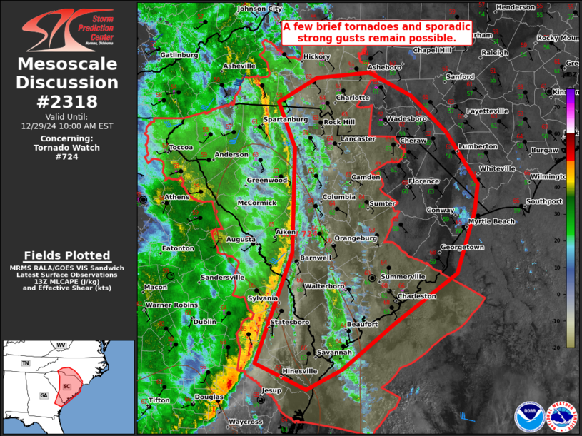
STATUS REPORT #2 ON WW 724
VALID 291335Z - 291440Z
SEVERE WEATHER THREAT CONTINUES RIGHT OF A LINE FROM 15 NNE VDI
TO 25 W CAE TO 20 ENE AVL.
FOR ADDITIONAL INFORMATION SEE MESOSCALE DISCUSSION 2318.
..GRAMS..12/29/24
ATTN...WFO...CHS...CAE...GSP...
&&
STATUS REPORT FOR WT 724
SEVERE WEATHER THREAT CONTINUES FOR THE FOLLOWING AREAS
GAC029-031-043-051-103-109-165-179-183-191-251-267-291440-
GA
. GEORGIA COUNTIES INCLUDED ARE
BRYAN BULLOCH CANDLER
CHATHAM EFFINGHAM EVANS
JENKINS LIBERTY LONG
MCINTOSH SCREVEN TATTNALL
$$
NCC003-023-025-035-045-059-071-097-109-119-159-161-179-291440-
NC
. NORTH CAROLINA COUNTIES INCLUDED ARE
ALEXANDER BURKE CABARRUS
CATAWBA CLEVELAND DAVIE
GASTON IREDELL LINCOLN
MECKLENBURG ROWAN RUTHERFORD
UNION
$$
SCC003-005-009-011-013-015-017-019-021-023-025-027-029-035-039-
049-053-055-057-061-063-071-075-079-083-085-087-091-291440-
SC
. SOUTH CAROLINA COUNTIES INCLUDED ARE
AIKEN ALLENDALE BAMBERG
BARNWELL BEAUFORT BERKELEY
CALHOUN CHARLESTON CHEROKEE
CHESTER CHESTERFIELD CLARENDON
COLLETON DORCHESTER FAIRFIELD
HAMPTON JASPER KERSHAW
LANCASTER LEE LEXINGTON
NEWBERRY ORANGEBURG RICHLAND
SPARTANBURG SUMTER UNION
YORK
$$
AMZ330-350-352-354-370-372-374-291440-
CW
. ADJACENT COASTAL WATERS INCLUDED ARE
CHARLESTON HARBOR
COASTAL WATERS FROM SOUTH SANTEE RIVER TO EDISTO BEACH SC OUT 20
NM
COASTAL WATERS FROM EDISTO BEACH SC TO SAVANNAH GA OUT 20 NM
COASTAL WATERS FROM SAVANNAH GA TO ALTAMAHA SOUND GA OUT 20 NM
...INCLUDING GRAYS REEF NATIONAL MARINE SANCTUARY
WATERS FROM SOUTH SANTEE RIVER SC TO EDISTO BEACH SC EXTENDING
FROM 20 NM TO 40 NM
WATERS FROM EDISTO BEACH SC TO SAVANNAH GA EXTENDING FROM 20 NM
TO 40 NM
WATERS FROM SAVANNAH GA TO ALTAMAHA SOUND GA EXTENDING FROM 20 NM
TO 60 NM
$$
THE WATCH STATUS MESSAGE IS FOR GUIDANCE PURPOSES ONLY. PLEASE
REFER TO WATCH COUNTY NOTIFICATION STATEMENTS FOR OFFICIAL
INFORMATION ON COUNTIES...INDEPENDENT CITIES AND MARINE ZONES
CLEARED FROM SEVERE THUNDERSTORM AND TORNADO WATCHES.
$$
STATUS REPORT #1 ON WW 724
VALID 291145Z - 291240Z
THE SEVERE WEATHER THREAT CONTINUES ACROSS THE ENTIRE WATCH AREA.
..GRAMS..12/29/24
ATTN...WFO...CHS...CAE...GSP...
&&
STATUS REPORT FOR WT 724
SEVERE WEATHER THREAT CONTINUES FOR THE FOLLOWING AREAS
GAC029-031-033-043-051-073-103-105-109-137-147-165-179-181-183-
189-191-241-245-251-257-267-291240-
GA
. GEORGIA COUNTIES INCLUDED ARE
BRYAN BULLOCH BURKE
CANDLER CHATHAM COLUMBIA
EFFINGHAM ELBERT EVANS
HABERSHAM HART JENKINS
LIBERTY LINCOLN LONG
MCDUFFIE MCINTOSH RABUN
RICHMOND SCREVEN STEPHENS
TATTNALL
$$
NCC003-023-025-035-045-059-071-097-109-119-149-159-161-179-
291240-
NC
. NORTH CAROLINA COUNTIES INCLUDED ARE
ALEXANDER BURKE CABARRUS
CATAWBA CLEVELAND DAVIE
GASTON IREDELL LINCOLN
MECKLENBURG POLK ROWAN
RUTHERFORD UNION
$$
SCC001-003-005-007-009-011-013-015-017-019-021-023-025-027-029-
035-037-039-045-047-049-053-055-057-059-061-063-065-071-073-075-
077-079-081-083-085-087-091-291240-
SC
. SOUTH CAROLINA COUNTIES INCLUDED ARE
ABBEVILLE AIKEN ALLENDALE
ANDERSON BAMBERG BARNWELL
BEAUFORT BERKELEY CALHOUN
CHARLESTON CHEROKEE CHESTER
CHESTERFIELD CLARENDON COLLETON
DORCHESTER EDGEFIELD FAIRFIELD
GREENVILLE GREENWOOD HAMPTON
JASPER KERSHAW LANCASTER
LAURENS LEE LEXINGTON
MCCORMICK NEWBERRY OCONEE
ORANGEBURG PICKENS RICHLAND
SALUDA SPARTANBURG SUMTER
UNION YORK
$$
AMZ330-350-352-354-291240-
CW
. ADJACENT COASTAL WATERS INCLUDED ARE
CHARLESTON HARBOR
COASTAL WATERS FROM SOUTH SANTEE RIVER TO EDISTO BEACH SC OUT 20
NM
COASTAL WATERS FROM EDISTO BEACH SC TO SAVANNAH GA OUT 20 NM
COASTAL WATERS FROM SAVANNAH GA TO ALTAMAHA SOUND GA OUT 20 NM
...INCLUDING GRAYS REEF NATIONAL MARINE SANCTUARY
$$
THE WATCH STATUS MESSAGE IS FOR GUIDANCE PURPOSES ONLY. PLEASE
REFER TO WATCH COUNTY NOTIFICATION STATEMENTS FOR OFFICIAL
INFORMATION ON COUNTIES...INDEPENDENT CITIES AND MARINE ZONES
CLEARED FROM SEVERE THUNDERSTORM AND TORNADO WATCHES.
$$
Note:
Click for Complete Product Text.
Tornadoes
Probability of 2 or more tornadoes
|
Mod (50%)
|
Probability of 1 or more strong (EF2-EF5) tornadoes
|
Low (20%)
|
Wind
Probability of 10 or more severe wind events
|
Mod (40%)
|
Probability of 1 or more wind events > 65 knots
|
Low (20%)
|
Hail
Probability of 10 or more severe hail events
|
Low (10%)
|
Probability of 1 or more hailstones > 2 inches
|
Low (<5%)
|
Combined Severe Hail/Wind
Probability of 6 or more combined severe hail/wind events
|
Mod (60%)
|
For each watch, probabilities for particular events inside the watch
(listed above in each table) are determined by the issuing forecaster.
The "Low" category contains probability values ranging from less than 2%
to 20% (EF2-EF5 tornadoes), less than 5% to 20% (all other probabilities),
"Moderate" from 30% to 60%, and "High" from 70% to greater than 95%.
High values are bolded and lighter in color to provide awareness of
an increased threat for a particular event.


 @NWSSPC