|
| Mesoscale Discussion 2324 |
|
< Previous MD
|

|
   Mesoscale Discussion 2324
   NWS Storm Prediction Center Norman OK
   0556 PM CST Tue Dec 31 2024

   Areas affected...Parts of the Mid Atlantic

   Concerning...Severe potential...Watch unlikely

   Valid 312356Z - 010200Z

   Probability of Watch Issuance...20 percent

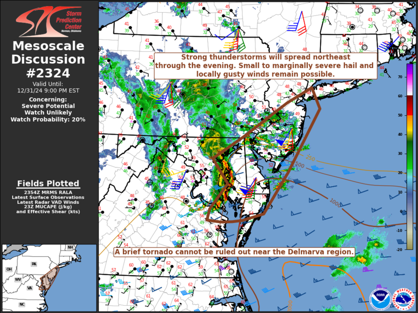
   SUMMARY...Strong thunderstorms will spread northeastward through the
   evening. Small to marginally severe hail and locally gusty winds
   remain possible. A brief tornado also cannot be ruled out near the
   Delmarva region.

   DISCUSSION...A long-lived thunderstorm cluster is moving
   northeastward across parts of eastern MD/VA early this evening, in
   association with a strong midlevel shortwave trough and 1000 mb
   surface low moving across the Mid Atlantic region. The northern
   portion of this cluster appears to be outpacing the northward return
   of modest surface-based instability, but increasing elevated
   moisture and buoyancy will help to maintain the cluster as it
   approaches DE and southern NJ. MUCAPE increasing to near/above 500
   J/kg and strong effective shear will continue to support organized
   convection.

   Small to marginally severe hail will continue to be possible with
   both the ongoing cluster and with elevated storms developing ahead
   of the cluster, due to cold temperatures aloft (below -20C at 500
   mb) associated with the shortwave trough. Increasing low-level
   stability may tend to limit the severe-wind threat with
   northeastward extent, though locally strong/damaging gusts may
   accompany the more organized convective elements, especially from
   southern NJ into the Delmarva. A brief tornado also cannot be ruled
   out where convection remains near-surface-based, especially near the
   Delmarva where the southern portion of the ongoing cluster will
   intercept modestly increasing MLCAPE.

   ..Dean/Bunting.. 12/31/2024

   ...Please see www.spc.noaa.gov for graphic product...

   ATTN...WFO...OKX...PHI...AKQ...LWX...

   LAT...LON   39257669 39757580 40507452 40847379 40367355 38947450
               38007522 37857582 37827611 37807644 37847684 38097676
               38687625 39257669
|
|
Top/All Mesoscale Discussions/Forecast Products/Home
|
|


