|
| Mesoscale Discussion 387 |
|
< Previous MD Next MD >
|
|
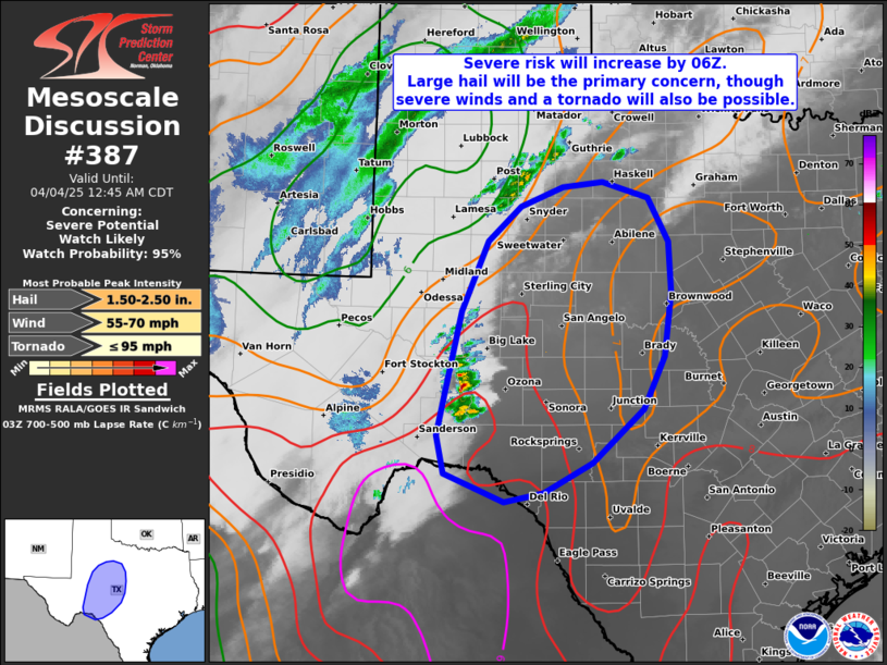
   Mesoscale Discussion 0387
   NWS Storm Prediction Center Norman OK
   1039 PM CDT Thu Apr 03 2025

   Areas affected...Portions of southwest and central Texas

   Concerning...Severe potential...Watch likely

   Valid 040339Z - 040545Z

   Probability of Watch Issuance...95 percent

   SUMMARY...The severe risk will increase by 06Z across portions of
   southwest and central Texas. Large hail will be the primary concern,
   though severe wind gusts and possibly a tornado cannot be ruled out.
   A watch will likely be issued within the hour.

   DISCUSSION...The latest water-vapor imagery loops and VWP data
   depict a midlevel impulse advancing northeastward across northern
   Mexico -- within the base of an amplified larger-scale trough over
   the West. In response, 850-700-mb warm advection will continue
   strengthening across southwest into central TX over the next few
   hours. This is already supporting isolated thunderstorms along the
   western edge of a steep midlevel lapse rate plume and related
   buoyancy (see latest SAT ACARS soundings). As the large-scale ascent
   continues spreading eastward, a rapid increase in thunderstorm
   development is expected within the steeper lapse rates, where
   2000-3000 J/kg MUCAPE (higher farther south) and 70+ kt of effective
   shear will favor organized thunderstorms including supercells. Most
   of these storms will be developing north of the surface-based
   instability and should remain elevated with a risk of large hail.
   However, any storms that develop farther south along the boundary
   may be near-surface-based, posing an additional risk of severe wind
   gusts and a tornado -- given ample low-level shear/clockwise-curved
   hodographs. A watch will likely be issued for parts of the area
   within the hour.

   ..Weinman/Hart.. 04/04/2025

   ...Please see www.spc.noaa.gov for graphic product...

   ATTN...WFO...FWD...EWX...SJT...LUB...MAF...

   LAT...LON   29700203 30160213 31620180 32440144 32850099 33090040
               33149985 32969923 32449894 31849892 31089902 30469931
               29830001 29480067 29370121 29700203

   MOST PROBABLE PEAK TORNADO INTENSITY...UP TO 95 MPH
   MOST PROBABLE PEAK WIND GUST...55-70 MPH
   MOST PROBABLE PEAK HAIL SIZE...1.50-2.50 IN
|
|
Top/All Mesoscale Discussions/Forecast Products/Home
|
|


 @NWSSPC