|
| Mesoscale Discussion 388 |
|
< Previous MD Next MD >
|
|
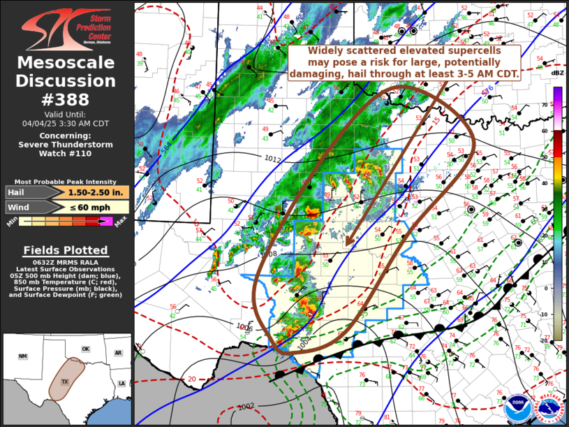
   Mesoscale Discussion 0388
   NWS Storm Prediction Center Norman OK
   0135 AM CDT Fri Apr 04 2025

   Areas affected...parts of w cntrl through nw Texas and adjacent swrn
   OK

   Concerning...Severe Thunderstorm Watch 110...

   Valid 040635Z - 040830Z

   The severe weather threat for Severe Thunderstorm Watch 110
   continues.

   SUMMARY...Strong to severe thunderstorms, posing primarily the risk
   for large, potentially damaging, hail appears likely to spread
   across and northeast of the San Angelo and Abilene vicinities
   through 3-5 AM CDT.  The extent to which this threat persists
   northward into the Red River Valley and north central Texas
   thereafter remains unclear, but trends are being monitored for the
   possibility of an additional severe weather watch.

   DISCUSSION...Numerous thunderstorms have developed the past few
   hours, including several sustained vigorous storms.  Activity is all
   rooted above shallow cold air to the north of a sharp surface front
   (now stalled near the College Station into Austin and Del Rio
   vicinities), focused along the northwestern periphery of capping
   elevated mixed-layer air, roughly delineated by temperatures of 8-10
   C around 700 mb.  Forecast soundings along this corridor exhibit
   "loaded gun" thermodynamic profiles, rooted within a moist layer
   between 850-700 mb, characterized by most unstable CAPE in excess of
   1000 J/kg.  Shear within the convective layer is strong and
   supportive of supercells.

   The more intense convection appears likely to shift with the
   stronger lower/mid-tropospheric forcing for ascent forecast to
   spread across the San Angelo toward Abilene vicinity during the next
   several hours.  There are indications in latest model output that
   further warming above the potentially more buoyant lower-level air
   mass could increasingly suppress stronger storm development toward
   09-10Z.  However, this remains uncertain.

   ..Kerr.. 04/04/2025

   ...Please see www.spc.noaa.gov for graphic product...

   ATTN...WFO...FWD...OUN...EWX...SJT...LUB...MAF...

   LAT...LON   29900169 31020205 33440049 34539894 33479738 31819887
               30080016 29690124 29900169

   MOST PROBABLE PEAK WIND GUST...UP TO 60 MPH
   MOST PROBABLE PEAK HAIL SIZE...1.50-2.50 IN
|
|
Top/All Mesoscale Discussions/Forecast Products/Home
|
|


 @NWSSPC