|
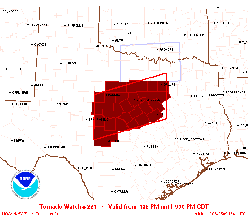
Initial List of Counties in SPC Tornado Watch 221 (WOU)
|
Back to Watch 221
|
 |
   WOUS64 KWNS 091833
   WOU1

   BULLETIN - IMMEDIATE BROADCAST REQUESTED
   TORNADO WATCH OUTLINE UPDATE FOR WT 221
   NWS STORM PREDICTION CENTER NORMAN OK
   135 PM CDT THU MAY 9 2024

   TORNADO WATCH 221 IS IN EFFECT UNTIL 900 PM CDT FOR THE
    FOLLOWING LOCATIONS

   TXC035-049-059-083-093-095-099-113-133-139-143-193-217-221-251-
   267-281-307-309-319-327-333-363-367-399-411-417-425-429-439-441-
   100200-
   /O.NEW.KWNS.TO.A.0221.240509T1835Z-240510T0200Z/

   TX
   .    TEXAS COUNTIES INCLUDED ARE

   BOSQUE               BROWN               CALLAHAN
   COLEMAN              COMANCHE            CONCHO
   CORYELL              DALLAS              EASTLAND
   ELLIS                ERATH               HAMILTON
   HILL                 HOOD                JOHNSON
   KIMBLE               LAMPASAS            MASON
   MCCULLOCH            MCLENNAN            MENARD
   MILLS                PALO PINTO          PARKER
   RUNNELS              SAN SABA            SHACKELFORD
   SOMERVELL            STEPHENS            TARRANT
   TAYLOR


   ATTN...WFO...FWD...SJT...
|
| Aviation Watch (SAW) for WW221 |
|---|
 |
| Note:
The Aviation Watch (SAW) product is an approximation to the watch area.
The actual watch is depicted by the shaded areas. |
   SAW1
   WW 221 TORNADO TX 091835Z - 100200Z
   AXIS..65 STATUTE MILES NORTH AND SOUTH OF LINE..
   35SSE DAL/DALLAS TX/ - 70SSW ABI/ABILENE TX/
   ..AVIATION COORDS.. 55NM N/S /36SE TTT - 18ENE SJT/
   HAIL SURFACE AND ALOFT..4 INCHES. WIND GUSTS..75 KNOTS.
   MAX TOPS TO 500. MEAN STORM MOTION VECTOR 27025.

   LAT...LON 31449662 30540013 32410013 33329662

   THIS IS AN APPROXIMATION TO THE WATCH AREA.  FOR A
   COMPLETE DEPICTION OF THE WATCH SEE WOUS64 KWNS
   FOR WOU1.
|
|


 @NWSSPC