 Note:
The expiration time in the watch graphic is amended if the watch is
replaced, cancelled or extended.
Note:
Note:
The expiration time in the watch graphic is amended if the watch is
replaced, cancelled or extended.
Note: Click for
Watch Status Reports.
SEL1
URGENT - IMMEDIATE BROADCAST REQUESTED
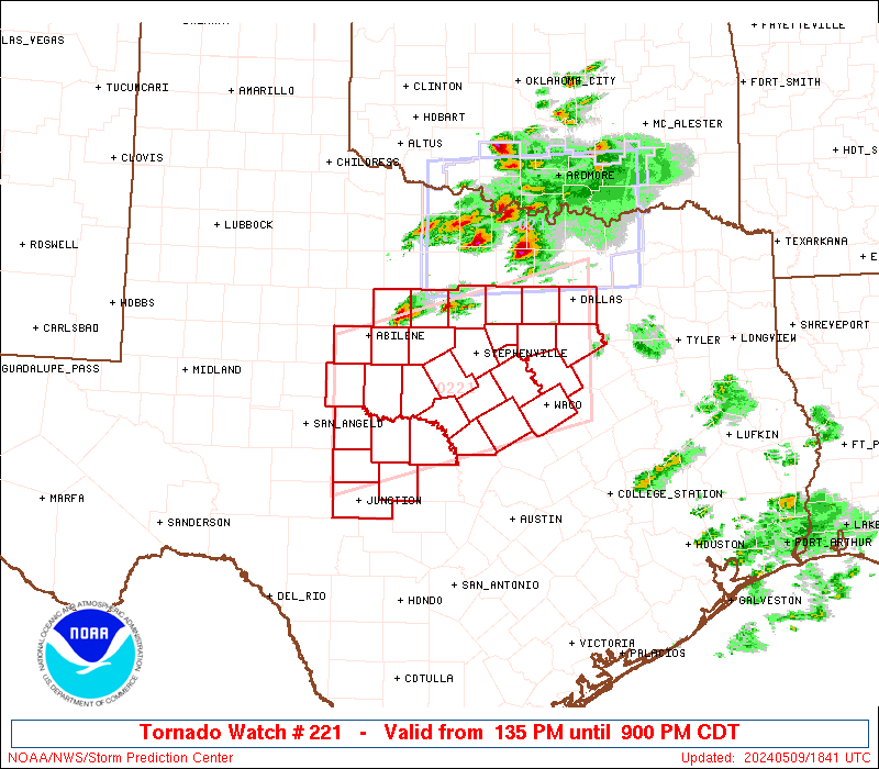
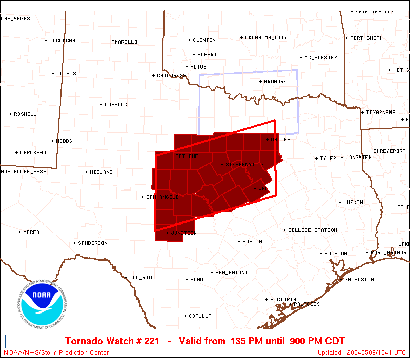
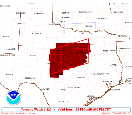
Tornado Watch Number 221
NWS Storm Prediction Center Norman OK
135 PM CDT Thu May 9 2024
The NWS Storm Prediction Center has issued a
* Tornado Watch for portions of
North-Central and Central Texas
* Effective this Thursday afternoon and evening from 135 PM until
900 PM CDT.
* Primary threats include...
A couple tornadoes possible
Scattered damaging winds and isolated significant gusts to 85
mph likely
Scattered large hail and isolated very large hail events to 4
inches in diameter likely
SUMMARY...Widely scattered to scattered thunderstorms are forecast
to develop this afternoon into the early evening. Several intense
supercells are likely and will be capable of large to giant hail
(max diameter 2 to 4 inches) and severe gusts. The tornado risk may
focus along the west to east oriented wind shift draped across parts
of north-central Texas. Eventual growth into a severe cluster of
supercells with accompanying significant hail and wind hazards may
evolve towards the evening.
The tornado watch area is approximately along and 65 statute miles
north and south of a line from 35 miles south southeast of Dallas TX
to 70 miles south southwest of Abilene TX. For a complete depiction
of the watch see the associated watch outline update (WOUS64 KWNS
WOU1).
PRECAUTIONARY/PREPAREDNESS ACTIONS...
REMEMBER...A Tornado Watch means conditions are favorable for
tornadoes and severe thunderstorms in and close to the watch
area. Persons in these areas should be on the lookout for
threatening weather conditions and listen for later statements
and possible warnings.
&&
OTHER WATCH INFORMATION...CONTINUE...WW 217...WW 218...WW
219...WW 220...
AVIATION...Tornadoes and a few severe thunderstorms with hail
surface and aloft to 4 inches. Extreme turbulence and surface wind
gusts to 75 knots. A few cumulonimbi with maximum tops to 500. Mean
storm motion vector 27025.
...Smith
 Note:
The Aviation Watch (SAW) product is an approximation to the watch area.
The actual watch is depicted by the shaded areas.
Note:
The Aviation Watch (SAW) product is an approximation to the watch area.
The actual watch is depicted by the shaded areas.
   SAW1
   WW 221 TORNADO TX 091835Z - 100200Z
   AXIS..65 STATUTE MILES NORTH AND SOUTH OF LINE..
   35SSE DAL/DALLAS TX/ - 70SSW ABI/ABILENE TX/
   ..AVIATION COORDS.. 55NM N/S /36SE TTT - 18ENE SJT/
   HAIL SURFACE AND ALOFT..4 INCHES. WIND GUSTS..75 KNOTS.
   MAX TOPS TO 500. MEAN STORM MOTION VECTOR 27025.

   LAT...LON 31449662 30540013 32410013 33329662

   THIS IS AN APPROXIMATION TO THE WATCH AREA.  FOR A
   COMPLETE DEPICTION OF THE WATCH SEE WOUS64 KWNS
   FOR WOU1.
Watch 221 Status Report Messages:
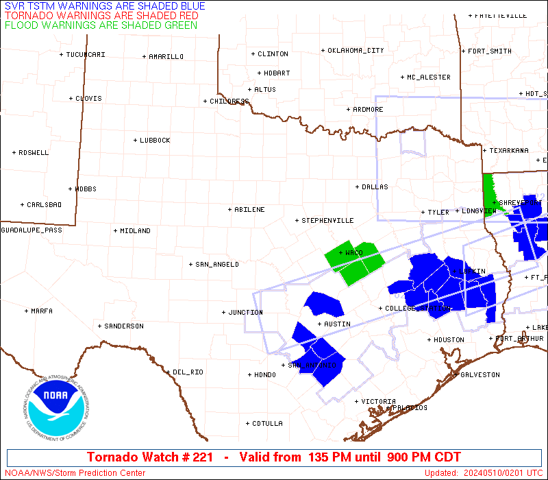
STATUS REPORT #7 ON WW 221
VALID 100010Z - 100200Z
SEVERE WEATHER THREAT CONTINUES RIGHT OF A LINE FROM 25 WSW TPL
TO 20 WSW ACT TO 10 ENE CRS.
WW 221 WILL BE ALLOWED TO EXPIRE AT 100200Z.
..SQUITIERI..05/10/24
ATTN...WFO...FWD...SJT...
&&
STATUS REPORT FOR WT 221
SEVERE WEATHER THREAT CONTINUES FOR THE FOLLOWING AREAS
TXC309-100200-
TX
. TEXAS COUNTIES INCLUDED ARE
MCLENNAN
$$
THE WATCH STATUS MESSAGE IS FOR GUIDANCE PURPOSES ONLY. PLEASE
REFER TO WATCH COUNTY NOTIFICATION STATEMENTS FOR OFFICIAL
INFORMATION ON COUNTIES...INDEPENDENT CITIES AND MARINE ZONES
CLEARED FROM SEVERE THUNDERSTORM AND TORNADO WATCHES.
$$
STATUS REPORT #6 ON WW 221
VALID 092245Z - 092340Z
SEVERE WEATHER THREAT CONTINUES RIGHT OF A LINE FROM 30 SSE SJT
TO 35 SSW BWD TO 30 E SEP TO 30 SE DAL.
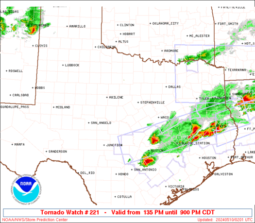
FOR ADDITIONAL INFORMATION SEE MESOSCALE DISCUSSION 735
..SQUITIERI..05/09/24
ATTN...WFO...FWD...SJT...
&&
STATUS REPORT FOR WT 221
SEVERE WEATHER THREAT CONTINUES FOR THE FOLLOWING AREAS
TXC035-099-139-193-217-251-267-281-307-309-319-327-333-411-
092340-
TX
. TEXAS COUNTIES INCLUDED ARE
BOSQUE CORYELL ELLIS
HAMILTON HILL JOHNSON
KIMBLE LAMPASAS MCCULLOCH
MCLENNAN MASON MENARD
MILLS SAN SABA
$$
THE WATCH STATUS MESSAGE IS FOR GUIDANCE PURPOSES ONLY. PLEASE
REFER TO WATCH COUNTY NOTIFICATION STATEMENTS FOR OFFICIAL
INFORMATION ON COUNTIES...INDEPENDENT CITIES AND MARINE ZONES
CLEARED FROM SEVERE THUNDERSTORM AND TORNADO WATCHES.
$$
STATUS REPORT #5 ON WW 221
VALID 092150Z - 092240Z
SEVERE WEATHER THREAT CONTINUES RIGHT OF A LINE FROM 15 E SJT TO
35 W BWD TO 15 NNE SEP TO 10 NW FTW TO 35 WSW GYI.
..BENTLEY..05/09/24
ATTN...WFO...FWD...SJT...
&&
STATUS REPORT FOR WT 221
SEVERE WEATHER THREAT CONTINUES FOR THE FOLLOWING AREAS
TXC035-049-083-093-095-099-113-139-143-193-217-221-251-267-281-
307-309-319-327-333-367-411-425-439-092240-
TX
. TEXAS COUNTIES INCLUDED ARE
BOSQUE BROWN COLEMAN
COMANCHE CONCHO CORYELL
DALLAS ELLIS ERATH
HAMILTON HILL HOOD
JOHNSON KIMBLE LAMPASAS
MCCULLOCH MCLENNAN MASON
MENARD MILLS PARKER
SAN SABA SOMERVELL TARRANT
$$
THE WATCH STATUS MESSAGE IS FOR GUIDANCE PURPOSES ONLY. PLEASE
REFER TO WATCH COUNTY NOTIFICATION STATEMENTS FOR OFFICIAL
INFORMATION ON COUNTIES...INDEPENDENT CITIES AND MARINE ZONES
CLEARED FROM SEVERE THUNDERSTORM AND TORNADO WATCHES.
$$
STATUS REPORT #4 ON WW 221
VALID 092120Z - 092240Z
SEVERE WEATHER THREAT CONTINUES RIGHT OF A LINE FROM 30 NNE SJT
TO 10 E ABI TO 45 WNW MWL.
..BENTLEY..05/09/24
ATTN...WFO...FWD...SJT...
&&
STATUS REPORT FOR WT 221
SEVERE WEATHER THREAT CONTINUES FOR THE FOLLOWING AREAS
TXC035-049-059-083-093-095-099-113-133-139-143-193-217-221-251-
267-281-307-309-319-327-333-363-367-399-411-425-429-439-
092240-
TX
. TEXAS COUNTIES INCLUDED ARE
BOSQUE BROWN CALLAHAN
COLEMAN COMANCHE CONCHO
CORYELL DALLAS EASTLAND
ELLIS ERATH HAMILTON
HILL HOOD JOHNSON
KIMBLE LAMPASAS MCCULLOCH
MCLENNAN MASON MENARD
MILLS PALO PINTO PARKER
RUNNELS SAN SABA SOMERVELL
STEPHENS TARRANT
$$
THE WATCH STATUS MESSAGE IS FOR GUIDANCE PURPOSES ONLY. PLEASE
REFER TO WATCH COUNTY NOTIFICATION STATEMENTS FOR OFFICIAL
INFORMATION ON COUNTIES...INDEPENDENT CITIES AND MARINE ZONES
CLEARED FROM SEVERE THUNDERSTORM AND TORNADO WATCHES.
$$
STATUS REPORT #3 ON WW 221
VALID 092050Z - 092140Z
SEVERE WEATHER THREAT CONTINUES RIGHT OF A LINE FROM 50 N SJT TO
25 SSE ABI TO 35 N BWD TO 20 W MWL TO 25 NNE MWL.
..JEWELL..05/09/24
ATTN...WFO...FWD...SJT...
&&
STATUS REPORT FOR WT 221
SEVERE WEATHER THREAT CONTINUES FOR THE FOLLOWING AREAS
TXC035-049-059-083-093-095-099-113-133-139-143-193-217-221-251-
267-281-307-309-319-327-333-363-367-399-411-425-429-439-
092140-
TX
. TEXAS COUNTIES INCLUDED ARE
BOSQUE BROWN CALLAHAN
COLEMAN COMANCHE CONCHO
CORYELL DALLAS EASTLAND
ELLIS ERATH HAMILTON
HILL HOOD JOHNSON
KIMBLE LAMPASAS MCCULLOCH
MCLENNAN MASON MENARD
MILLS PALO PINTO PARKER
RUNNELS SAN SABA SOMERVELL
STEPHENS TARRANT
$$
THE WATCH STATUS MESSAGE IS FOR GUIDANCE PURPOSES ONLY. PLEASE
REFER TO WATCH COUNTY NOTIFICATION STATEMENTS FOR OFFICIAL
INFORMATION ON COUNTIES...INDEPENDENT CITIES AND MARINE ZONES
CLEARED FROM SEVERE THUNDERSTORM AND TORNADO WATCHES.
$$
STATUS REPORT #2 ON WW 221
VALID 092030Z - 092140Z
THE SEVERE WEATHER THREAT CONTINUES ACROSS THE ENTIRE WATCH AREA.
..BENTLEY..05/09/24
ATTN...WFO...FWD...SJT...
&&
STATUS REPORT FOR WT 221
SEVERE WEATHER THREAT CONTINUES FOR THE FOLLOWING AREAS
TXC035-049-059-083-093-095-099-113-133-139-143-193-217-221-251-
267-281-307-309-319-327-333-363-367-399-411-417-425-429-439-441-
092140-
TX
. TEXAS COUNTIES INCLUDED ARE
BOSQUE BROWN CALLAHAN
COLEMAN COMANCHE CONCHO
CORYELL DALLAS EASTLAND
ELLIS ERATH HAMILTON
HILL HOOD JOHNSON
KIMBLE LAMPASAS MCCULLOCH
MCLENNAN MASON MENARD
MILLS PALO PINTO PARKER
RUNNELS SAN SABA SHACKELFORD
SOMERVELL STEPHENS TARRANT
TAYLOR
$$
THE WATCH STATUS MESSAGE IS FOR GUIDANCE PURPOSES ONLY. PLEASE
REFER TO WATCH COUNTY NOTIFICATION STATEMENTS FOR OFFICIAL
INFORMATION ON COUNTIES...INDEPENDENT CITIES AND MARINE ZONES
CLEARED FROM SEVERE THUNDERSTORM AND TORNADO WATCHES.
$$
STATUS REPORT #1 ON WW 221
VALID 091925Z - 092040Z
THE SEVERE WEATHER THREAT CONTINUES ACROSS THE ENTIRE WATCH AREA.
..BENTLEY..05/09/24
ATTN...WFO...FWD...SJT...
&&
STATUS REPORT FOR WT 221
SEVERE WEATHER THREAT CONTINUES FOR THE FOLLOWING AREAS
TXC035-049-059-083-093-095-099-113-133-139-143-193-217-221-251-
267-281-307-309-319-327-333-363-367-399-411-417-425-429-439-441-
092040-
TX
. TEXAS COUNTIES INCLUDED ARE
BOSQUE BROWN CALLAHAN
COLEMAN COMANCHE CONCHO
CORYELL DALLAS EASTLAND
ELLIS ERATH HAMILTON
HILL HOOD JOHNSON
KIMBLE LAMPASAS MCCULLOCH
MCLENNAN MASON MENARD
MILLS PALO PINTO PARKER
RUNNELS SAN SABA SHACKELFORD
SOMERVELL STEPHENS TARRANT
TAYLOR
$$
THE WATCH STATUS MESSAGE IS FOR GUIDANCE PURPOSES ONLY. PLEASE
REFER TO WATCH COUNTY NOTIFICATION STATEMENTS FOR OFFICIAL
INFORMATION ON COUNTIES...INDEPENDENT CITIES AND MARINE ZONES
CLEARED FROM SEVERE THUNDERSTORM AND TORNADO WATCHES.
$$
Note:
Click for Complete Product Text.
Tornadoes
Probability of 2 or more tornadoes
|
Mod (40%)
|
Probability of 1 or more strong (EF2-EF5) tornadoes
|
Low (20%)
|
Wind
Probability of 10 or more severe wind events
|
Mod (60%)
|
Probability of 1 or more wind events > 65 knots
|
Mod (60%)
|
Hail
Probability of 10 or more severe hail events
|
Mod (60%)
|
Probability of 1 or more hailstones > 2 inches
|
Mod (60%)
|
Combined Severe Hail/Wind
Probability of 6 or more combined severe hail/wind events
|
High (>95%)
|
For each watch, probabilities for particular events inside the watch
(listed above in each table) are determined by the issuing forecaster.
The "Low" category contains probability values ranging from less than 2%
to 20% (EF2-EF5 tornadoes), less than 5% to 20% (all other probabilities),
"Moderate" from 30% to 60%, and "High" from 70% to greater than 95%.
High values are bolded and lighter in color to provide awareness of
an increased threat for a particular event.


 @NWSSPC