Note:
The expiration time in the watch graphic is amended if the watch is
replaced, cancelled or extended.
Note:
Note:
The expiration time in the watch graphic is amended if the watch is
replaced, cancelled or extended.
Note: Click for
Watch Status Reports.
SEL9
URGENT - IMMEDIATE BROADCAST REQUESTED
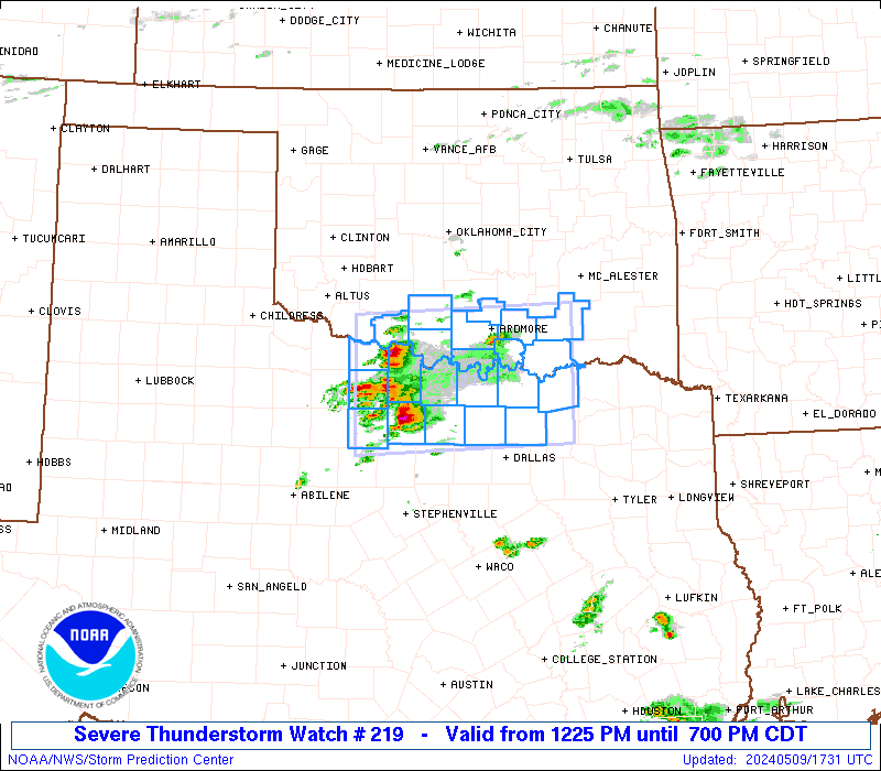
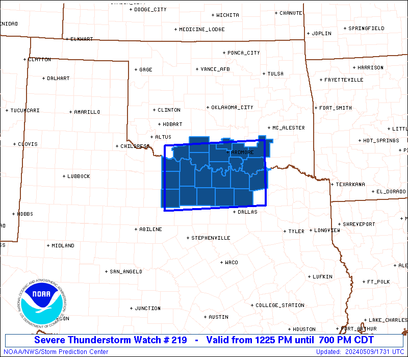
Severe Thunderstorm Watch Number 219
NWS Storm Prediction Center Norman OK
1225 PM CDT Thu May 9 2024
The NWS Storm Prediction Center has issued a
* Severe Thunderstorm Watch for portions of
Southern Oklahoma
North Texas
* Effective this Thursday afternoon and evening from 1225 PM
until 700 PM CDT.
* Primary threats include...
Scattered large hail and isolated very large hail events to 3.5
inches in diameter likely
Scattered damaging wind gusts to 70 mph possible
SUMMARY...Several supercells are forecast to move across the Watch
area this afternoon into the early evening. Large to giant hail
will be likely with any robust supercell and severe gusts are also
possible.
The severe thunderstorm watch area is approximately along and 55
statute miles north and south of a line from 30 miles southwest of
Wichita Falls TX to 30 miles east southeast of Durant OK. For a
complete depiction of the watch see the associated watch outline
update (WOUS64 KWNS WOU9).
PRECAUTIONARY/PREPAREDNESS ACTIONS...
REMEMBER...A Severe Thunderstorm Watch means conditions are
favorable for severe thunderstorms in and close to the watch area.
Persons in these areas should be on the lookout for threatening
weather conditions and listen for later statements and possible
warnings. Severe thunderstorms can and occasionally do produce
tornadoes.
&&
OTHER WATCH INFORMATION...CONTINUE...WW 217...WW 218...
AVIATION...A few severe thunderstorms with hail surface and aloft to
3.5 inches. Extreme turbulence and surface wind gusts to 60 knots. A
few cumulonimbi with maximum tops to 500. Mean storm motion vector
24030.
...Smith
 Note:
The Aviation Watch (SAW) product is an approximation to the watch area.
The actual watch is depicted by the shaded areas.
Note:
The Aviation Watch (SAW) product is an approximation to the watch area.
The actual watch is depicted by the shaded areas.
   SAW9
   WW 219 SEVERE TSTM OK TX 091725Z - 100000Z
   AXIS..55 STATUTE MILES NORTH AND SOUTH OF LINE..
   30SW SPS/WICHITA FALLS TX/ - 30ESE DUA/DURANT OK/
   ..AVIATION COORDS.. 50NM N/S /24SW SPS - 64S MLC/
   HAIL SURFACE AND ALOFT..3.5 INCHES. WIND GUSTS..60 KNOTS.
   MAX TOPS TO 500. MEAN STORM MOTION VECTOR 24030.

   LAT...LON 34469887 34589592 32999592 32879887

   THIS IS AN APPROXIMATION TO THE WATCH AREA.  FOR A
   COMPLETE DEPICTION OF THE WATCH SEE WOUS64 KWNS
   FOR WOU9.
Watch 219 Status Report Messages:
STATUS REPORT #4 ON WW 219

VALID 092240Z - 100000Z

SEVERE WEATHER THREAT CONTINUES RIGHT OF A LINE FROM 45 E DAL TO
20 S GYI TO 10 N GYI TO 35 NNW PRX.

WW 219 WILL BE ALLOWED TO EXPIRE AT 100000Z.

..SQUITIERI..05/09/24

ATTN...WFO...OUN...FWD...

&&

STATUS REPORT FOR WS 219

SEVERE WEATHER THREAT CONTINUES FOR THE FOLLOWING AREAS

OKC013-100000-

OK
.    OKLAHOMA COUNTIES INCLUDED ARE

BRYAN
$$


TXC147-181-100000-

TX
.    TEXAS COUNTIES INCLUDED ARE

FANNIN		     GRAYSON
$$


THE WATCH STATUS MESSAGE IS FOR GUIDANCE PURPOSES ONLY.  PLEASE
REFER TO WATCH COUNTY NOTIFICATION STATEMENTS FOR OFFICIAL
INFORMATION ON COUNTIES...INDEPENDENT CITIES AND MARINE ZONES
CLEARED FROM SEVERE THUNDERSTORM AND TORNADO WATCHES.
$$

STATUS REPORT #3 ON WW 219

VALID 092155Z - 092240Z

SEVERE WEATHER THREAT CONTINUES RIGHT OF A LINE FROM 10 NE MWL TO
45 N FTW TO 20 S ADM TO 25 S MLC.

..BENTLEY..05/09/24

ATTN...WFO...OUN...FWD...

&&

STATUS REPORT FOR WS 219

SEVERE WEATHER THREAT CONTINUES FOR THE FOLLOWING AREAS

OKC013-085-095-092240-

OK
.    OKLAHOMA COUNTIES INCLUDED ARE

BRYAN		     LOVE		 MARSHALL
$$


TXC085-097-121-147-181-497-092240-

TX
.    TEXAS COUNTIES INCLUDED ARE

COLLIN		     COOKE		 DENTON
FANNIN		     GRAYSON		 WISE
$$


THE WATCH STATUS MESSAGE IS FOR GUIDANCE PURPOSES ONLY.  PLEASE
REFER TO WATCH COUNTY NOTIFICATION STATEMENTS FOR OFFICIAL
INFORMATION ON COUNTIES...INDEPENDENT CITIES AND MARINE ZONES
CLEARED FROM SEVERE THUNDERSTORM AND TORNADO WATCHES.
$$

STATUS REPORT #2 ON WW 219

VALID 092050Z - 092140Z

SEVERE WEATHER THREAT CONTINUES RIGHT OF A LINE FROM 35 SW SPS TO
45 SW ADM TO 15 NNE DUA TO 40 N PRX.

..JEWELL..05/09/24

ATTN...WFO...OUN...FWD...

&&

STATUS REPORT FOR WS 219

SEVERE WEATHER THREAT CONTINUES FOR THE FOLLOWING AREAS

OKC013-085-095-092140-

OK
.    OKLAHOMA COUNTIES INCLUDED ARE

BRYAN		     LOVE		 MARSHALL
$$


TXC009-077-085-097-121-147-181-237-337-497-503-092140-

TX
.    TEXAS COUNTIES INCLUDED ARE

ARCHER		     CLAY		 COLLIN
COOKE		     DENTON		 FANNIN
GRAYSON 	     JACK		 MONTAGUE
WISE		     YOUNG
$$


THE WATCH STATUS MESSAGE IS FOR GUIDANCE PURPOSES ONLY.  PLEASE
REFER TO WATCH COUNTY NOTIFICATION STATEMENTS FOR OFFICIAL
INFORMATION ON COUNTIES...INDEPENDENT CITIES AND MARINE ZONES
CLEARED FROM SEVERE THUNDERSTORM AND TORNADO WATCHES.
$$

STATUS REPORT #1 ON WW 219

VALID 091925Z - 092040Z

THE SEVERE WEATHER THREAT CONTINUES ACROSS THE ENTIRE WATCH AREA.

..BENTLEY..05/09/24

ATTN...WFO...OUN...FWD...

&&

STATUS REPORT FOR WS 219

SEVERE WEATHER THREAT CONTINUES FOR THE FOLLOWING AREAS

OKC005-013-019-033-067-069-085-095-099-137-092040-

OK
.    OKLAHOMA COUNTIES INCLUDED ARE

ATOKA		     BRYAN		 CARTER
COTTON		     JEFFERSON		 JOHNSTON
LOVE		     MARSHALL		 MURRAY
STEPHENS
$$


TXC009-077-085-097-121-147-181-237-337-485-497-503-092040-

TX
.    TEXAS COUNTIES INCLUDED ARE

ARCHER		     CLAY		 COLLIN
COOKE		     DENTON		 FANNIN
GRAYSON 	     JACK		 MONTAGUE
WICHITA 	     WISE		 YOUNG
$$


THE WATCH STATUS MESSAGE IS FOR GUIDANCE PURPOSES ONLY.  PLEASE
REFER TO WATCH COUNTY NOTIFICATION STATEMENTS FOR OFFICIAL
INFORMATION ON COUNTIES...INDEPENDENT CITIES AND MARINE ZONES
CLEARED FROM SEVERE THUNDERSTORM AND TORNADO WATCHES.
$$
Note:
Click for Complete Product Text.
Tornadoes
Probability of 2 or more tornadoes
|
Low (10%)
|
Probability of 1 or more strong (EF2-EF5) tornadoes
|
Low (<2%)
|
Wind
Probability of 10 or more severe wind events
|
Mod (40%)
|
Probability of 1 or more wind events > 65 knots
|
Low (20%)
|
Hail
Probability of 10 or more severe hail events
|
High (70%)
|
Probability of 1 or more hailstones > 2 inches
|
High (70%)
|
Combined Severe Hail/Wind
Probability of 6 or more combined severe hail/wind events
|
High (90%)
|
For each watch, probabilities for particular events inside the watch
(listed above in each table) are determined by the issuing forecaster.
The "Low" category contains probability values ranging from less than 2%
to 20% (EF2-EF5 tornadoes), less than 5% to 20% (all other probabilities),
"Moderate" from 30% to 60%, and "High" from 70% to greater than 95%.
High values are bolded and lighter in color to provide awareness of
an increased threat for a particular event.


 @NWSSPC