|
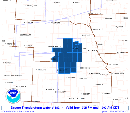
Initial List of Counties in SPC Severe Thunderstorm Watch 382 (WOU)
|
Back to Watch 382
|
 |
   WOUS64 KWNS 030002
   WOU2

   BULLETIN - IMMEDIATE BROADCAST REQUESTED
   SEVERE THUNDERSTORM WATCH OUTLINE UPDATE FOR WS 382
   NWS STORM PREDICTION CENTER NORMAN OK
   705 PM CDT SUN JUN 2 2024

   SEVERE THUNDERSTORM WATCH 382 IS IN EFFECT UNTIL 1200 AM CDT
   FOR THE FOLLOWING LOCATIONS

   KSC089-123-141-147-163-183-030500-
   /O.NEW.KWNS.SV.A.0382.240603T0005Z-240603T0500Z/

   KS
   .    KANSAS COUNTIES INCLUDED ARE

   JEWELL               MITCHELL            OSBORNE
   PHILLIPS             ROOKS               SMITH


   NEC001-019-035-047-059-061-065-073-077-079-081-083-093-099-121-
   125-129-137-143-163-169-175-181-185-030500-
   /O.NEW.KWNS.SV.A.0382.240603T0005Z-240603T0500Z/

   NE
   .    NEBRASKA COUNTIES INCLUDED ARE

   ADAMS                BUFFALO             CLAY
   DAWSON               FILLMORE            FRANKLIN
   FURNAS               GOSPER              GREELEY
   HALL                 HAMILTON            HARLAN
   HOWARD               KEARNEY             MERRICK
   NANCE                NUCKOLLS            PHELPS
   POLK                 SHERMAN             THAYER
   VALLEY               WEBSTER             YORK


   ATTN...WFO...GID...
|
| Aviation Watch (SAW) for WW382 |
|---|
 |
| Note:
The Aviation Watch (SAW) product is an approximation to the watch area.
The actual watch is depicted by the shaded areas. |
   SAW2
   WW 382 SEVERE TSTM KS NE 030005Z - 030500Z
   AXIS..60 STATUTE MILES EAST AND WEST OF LINE..
   55ENE BBW/BROKEN BOW NE/ - 60WSW CNK/CONCORDIA KS/
   ..AVIATION COORDS.. 50NM E/W /25NNW OBH - 52WNW SLN/
   HAIL SURFACE AND ALOFT..2 INCHES. WIND GUSTS..70 KNOTS.
   MAX TOPS TO 500. MEAN STORM MOTION VECTOR 28035.

   LAT...LON 41729748 39209756 39209981 41729981

   THIS IS AN APPROXIMATION TO THE WATCH AREA.  FOR A
   COMPLETE DEPICTION OF THE WATCH SEE WOUS64 KWNS
   FOR WOU2.
|
|


 @NWSSPC
