Note:
The expiration time in the watch graphic is amended if the watch is
replaced, cancelled or extended.
Note:
Note:
The expiration time in the watch graphic is amended if the watch is
replaced, cancelled or extended.
Note: Click for
Watch Status Reports.
SEL2
URGENT - IMMEDIATE BROADCAST REQUESTED
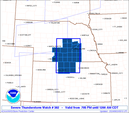
Severe Thunderstorm Watch Number 382
NWS Storm Prediction Center Norman OK
705 PM CDT Sun Jun 2 2024
The NWS Storm Prediction Center has issued a
* Severe Thunderstorm Watch for portions of
North Central Kansas
Central Nebraska
* Effective this Sunday night from 705 PM until Midnight CDT.
* Primary threats include...
Widespread damaging winds and isolated significant gusts to 80
mph likely
Scattered large hail and isolated very large hail events to 2
inches in diameter likely
A tornado or two possible
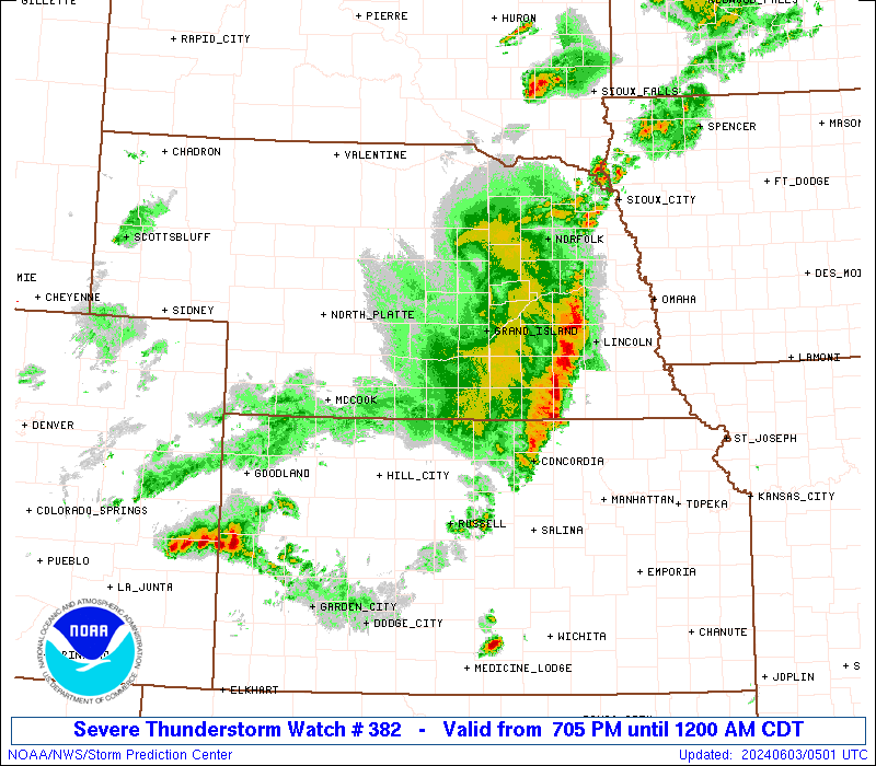
SUMMARY...A fast-moving line of thunderstorms over western Nebraska
will track across the watch area this evening, posing a risk of
widespread damaging winds and hail.
The severe thunderstorm watch area is approximately along and 60
statute miles east and west of a line from 55 miles east northeast
of Broken Bow NE to 60 miles west southwest of Concordia KS. For a
complete depiction of the watch see the associated watch outline
update (WOUS64 KWNS WOU2).
PRECAUTIONARY/PREPAREDNESS ACTIONS...
REMEMBER...A Severe Thunderstorm Watch means conditions are
favorable for severe thunderstorms in and close to the watch area.
Persons in these areas should be on the lookout for threatening
weather conditions and listen for later statements and possible
warnings. Severe thunderstorms can and occasionally do produce
tornadoes.
&&
OTHER WATCH INFORMATION...CONTINUE...WW 373...WW 374...WW
375...WW 376...WW 377...WW 378...WW 379...WW 380...WW 381...
AVIATION...A few severe thunderstorms with hail surface and aloft to
2 inches. Extreme turbulence and surface wind gusts to 70 knots. A
few cumulonimbi with maximum tops to 500. Mean storm motion vector
28035.
...Hart
   SEL2

   URGENT - IMMEDIATE BROADCAST REQUESTED
   Severe Thunderstorm Watch Number 382
   NWS Storm Prediction Center Norman OK
   705 PM CDT Sun Jun 2 2024

   The NWS Storm Prediction Center has issued a

   * Severe Thunderstorm Watch for portions of
     North Central Kansas
     Central Nebraska

   * Effective this Sunday night from 705 PM until Midnight CDT.

   * Primary threats include...
     Widespread damaging winds and isolated significant gusts to 80
       mph likely
     Scattered large hail and isolated very large hail events to 2
       inches in diameter likely
     A tornado or two possible

   SUMMARY...A fast-moving line of thunderstorms over western Nebraska
   will track across the watch area this evening, posing a risk of
   widespread damaging winds and hail.

   The severe thunderstorm watch area is approximately along and 60
   statute miles east and west of a line from 55 miles east northeast
   of Broken Bow NE to 60 miles west southwest of Concordia KS. For a
   complete depiction of the watch see the associated watch outline
   update (WOUS64 KWNS WOU2).

   PRECAUTIONARY/PREPAREDNESS ACTIONS...

   REMEMBER...A Severe Thunderstorm Watch means conditions are
   favorable for severe thunderstorms in and close to the watch area.
   Persons in these areas should be on the lookout for threatening
   weather conditions and listen for later statements and possible
   warnings. Severe thunderstorms can and occasionally do produce
   tornadoes.

   &&

   OTHER WATCH INFORMATION...CONTINUE...WW 373...WW 374...WW
   375...WW 376...WW 377...WW 378...WW 379...WW 380...WW 381...

   AVIATION...A few severe thunderstorms with hail surface and aloft to
   2 inches. Extreme turbulence and surface wind gusts to 70 knots. A
   few cumulonimbi with maximum tops to 500. Mean storm motion vector
   28035.

   ...Hart
 Note:
The Aviation Watch (SAW) product is an approximation to the watch area.
The actual watch is depicted by the shaded areas.
Note:
The Aviation Watch (SAW) product is an approximation to the watch area.
The actual watch is depicted by the shaded areas.
SAW2
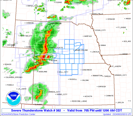
WW 382 SEVERE TSTM KS NE 030005Z - 030500Z
AXIS..60 STATUTE MILES EAST AND WEST OF LINE..
55ENE BBW/BROKEN BOW NE/ - 60WSW CNK/CONCORDIA KS/
..AVIATION COORDS.. 50NM E/W /25NNW OBH - 52WNW SLN/
HAIL SURFACE AND ALOFT..2 INCHES. WIND GUSTS..70 KNOTS.
MAX TOPS TO 500. MEAN STORM MOTION VECTOR 28035.
LAT...LON 41729748 39209756 39209981 41729981
THIS IS AN APPROXIMATION TO THE WATCH AREA. FOR A
COMPLETE DEPICTION OF THE WATCH SEE WOUS64 KWNS
FOR WOU2.
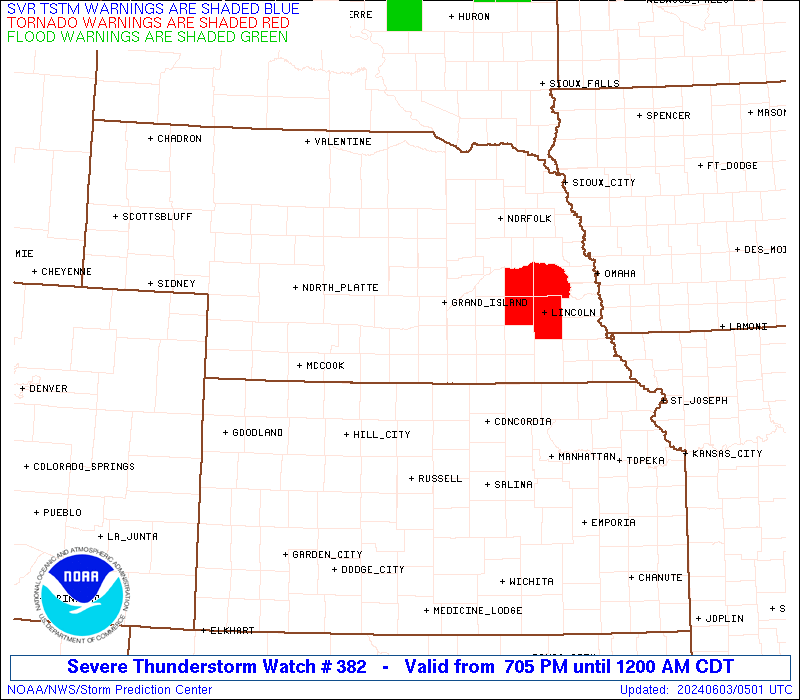
Watch 382 Status Report Messages:
STATUS REPORT #2 ON WW 382

VALID 030455Z - 030540Z

SEVERE WEATHER THREAT CONTINUES RIGHT OF A LINE FROM 25 NE RSL TO
40 ESE HSI TO 25 SW OLU TO 25 WSW OFK.

..BROYLES..06/03/24

ATTN...WFO...GID...

&&

STATUS REPORT FOR WS 382

SEVERE WEATHER THREAT CONTINUES FOR THE FOLLOWING AREAS

KSC123-030540-

KS
.    KANSAS COUNTIES INCLUDED ARE

MITCHELL
$$


NEC059-099-143-169-185-030540-

NE
.    NEBRASKA COUNTIES INCLUDED ARE

FILLMORE	     KEARNEY		 POLK
THAYER		     YORK
$$


THE WATCH STATUS MESSAGE IS FOR GUIDANCE PURPOSES ONLY.  PLEASE
REFER TO WATCH COUNTY NOTIFICATION STATEMENTS FOR OFFICIAL
INFORMATION ON COUNTIES...INDEPENDENT CITIES AND MARINE ZONES
CLEARED FROM SEVERE THUNDERSTORM AND TORNADO WATCHES.
$$

STATUS REPORT #1 ON WW 382

VALID 030055Z - 030140Z

THE SEVERE WEATHER THREAT CONTINUES ACROSS THE ENTIRE WATCH AREA.

..SUPINIE..06/03/24

ATTN...WFO...GID...

&&

STATUS REPORT FOR WS 382

SEVERE WEATHER THREAT CONTINUES FOR THE FOLLOWING AREAS

KSC089-123-141-147-163-183-030140-

KS
.    KANSAS COUNTIES INCLUDED ARE

JEWELL		     MITCHELL		 OSBORNE
PHILLIPS	     ROOKS		 SMITH
$$


NEC001-019-035-047-059-061-065-073-077-079-081-083-093-099-121-
125-129-137-143-163-169-175-181-185-030140-

NE
.    NEBRASKA COUNTIES INCLUDED ARE

ADAMS		     BUFFALO		 CLAY
DAWSON		     FILLMORE		 FRANKLIN
FURNAS		     GOSPER		 GREELEY
HALL		     HAMILTON		 HARLAN
HOWARD		     KEARNEY		 MERRICK
NANCE		     NUCKOLLS		 PHELPS
POLK		     SHERMAN		 THAYER
VALLEY		     WEBSTER		 YORK
$$


THE WATCH STATUS MESSAGE IS FOR GUIDANCE PURPOSES ONLY.  PLEASE
REFER TO WATCH COUNTY NOTIFICATION STATEMENTS FOR OFFICIAL
INFORMATION ON COUNTIES...INDEPENDENT CITIES AND MARINE ZONES
CLEARED FROM SEVERE THUNDERSTORM AND TORNADO WATCHES.
$$
Note:
Click for Complete Product Text.
Tornadoes
Probability of 2 or more tornadoes
|
Low (20%)
|
Probability of 1 or more strong (EF2-EF5) tornadoes
|
Low (5%)
|
Wind
Probability of 10 or more severe wind events
|
High (80%)
|
Probability of 1 or more wind events > 65 knots
|
High (70%)
|
Hail
Probability of 10 or more severe hail events
|
Mod (60%)
|
Probability of 1 or more hailstones > 2 inches
|
Mod (60%)
|
Combined Severe Hail/Wind
Probability of 6 or more combined severe hail/wind events
|
High (>95%)
|
For each watch, probabilities for particular events inside the watch
(listed above in each table) are determined by the issuing forecaster.
The "Low" category contains probability values ranging from less than 2%
to 20% (EF2-EF5 tornadoes), less than 5% to 20% (all other probabilities),
"Moderate" from 30% to 60%, and "High" from 70% to greater than 95%.
High values are bolded and lighter in color to provide awareness of
an increased threat for a particular event.


 @NWSSPC