Note:
The expiration time in the watch graphic is amended if the watch is
replaced, cancelled or extended.
Note:
Note:
The expiration time in the watch graphic is amended if the watch is
replaced, cancelled or extended.
Note: Click for
Watch Status Reports.
SEL7
URGENT - IMMEDIATE BROADCAST REQUESTED
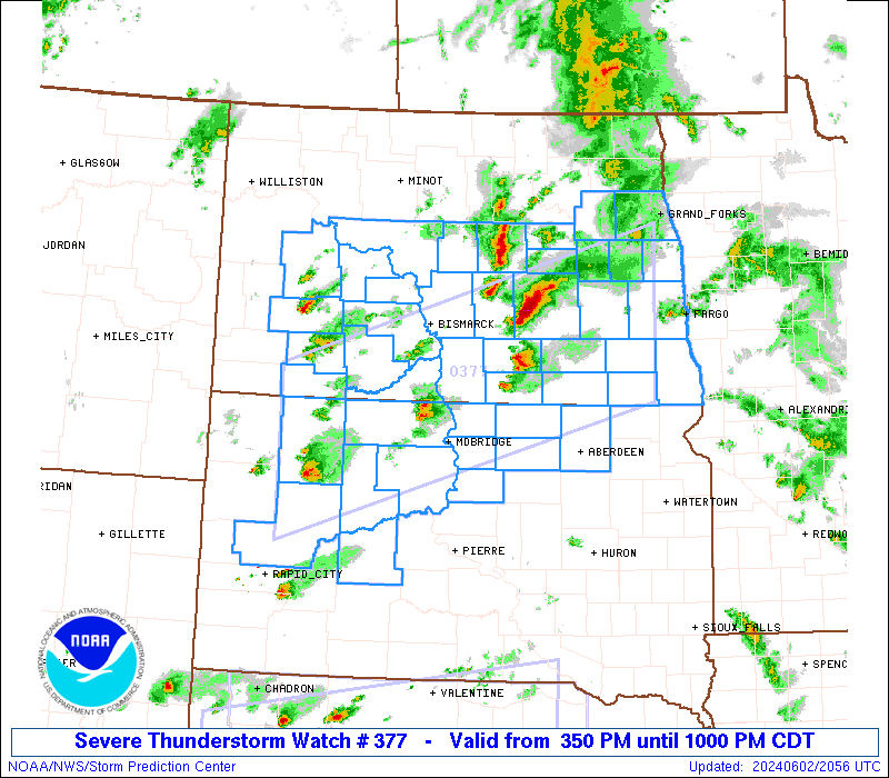
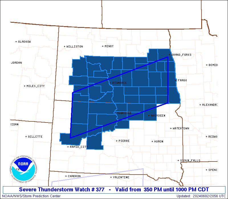
Severe Thunderstorm Watch Number 377
NWS Storm Prediction Center Norman OK
350 PM CDT Sun Jun 2 2024
The NWS Storm Prediction Center has issued a
* Severe Thunderstorm Watch for portions of
much of central and southern North Dakota
parts of western and northern South Dakota
* Effective this Sunday afternoon and evening from 350 PM until
1000 PM CDT.
* Primary threats include...
Scattered large hail likely with isolated very large hail events
to 2 inches in diameter possible
Scattered damaging wind gusts to 70 mph possible
SUMMARY...Widely scattered strong/locally severe storms will
continue to spread slowly eastward across WW 377 this afternoon and
into this evening. Large hail and locally damaging wind gusts will
be the primary severe threats with stronger/longer-lived storms.
The severe thunderstorm watch area is approximately along and 65
statute miles north and south of a line from 55 miles southwest of
Lemmon SD to 65 miles east of Jamestown ND. For a complete depiction
of the watch see the associated watch outline update (WOUS64 KWNS
WOU7).
PRECAUTIONARY/PREPAREDNESS ACTIONS...
REMEMBER...A Severe Thunderstorm Watch means conditions are
favorable for severe thunderstorms in and close to the watch area.
Persons in these areas should be on the lookout for threatening
weather conditions and listen for later statements and possible
warnings. Severe thunderstorms can and occasionally do produce
tornadoes.
&&
OTHER WATCH INFORMATION...CONTINUE...WW 372...WW 373...WW
374...WW 375...
AVIATION...A few severe thunderstorms with hail surface and aloft to
2 inches. Extreme turbulence and surface wind gusts to 60 knots. A
few cumulonimbi with maximum tops to 500. Mean storm motion vector
26020.
...Goss
 Note:
The Aviation Watch (SAW) product is an approximation to the watch area.
The actual watch is depicted by the shaded areas.
Note:
The Aviation Watch (SAW) product is an approximation to the watch area.
The actual watch is depicted by the shaded areas.
   SAW7
   WW 377 SEVERE TSTM ND SD 022050Z - 030300Z
   AXIS..65 STATUTE MILES NORTH AND SOUTH OF LINE..
   55SW Y22/LEMMON SD/ - 65E JMS/JAMESTOWN ND/
   ..AVIATION COORDS.. 55NM N/S /56WNW DPR - 21WNW FAR/
   HAIL SURFACE AND ALOFT..2 INCHES. WIND GUSTS..60 KNOTS.
   MAX TOPS TO 500. MEAN STORM MOTION VECTOR 26020.

   LAT...LON 46310297 47869730 45989730 44420297

   THIS IS AN APPROXIMATION TO THE WATCH AREA.  FOR A
   COMPLETE DEPICTION OF THE WATCH SEE WOUS64 KWNS
   FOR WOU7.
Watch 377 Status Report Messages:
STATUS REPORT #5 ON WW 377
VALID 030140Z - 030240Z
SEVERE WEATHER THREAT CONTINUES RIGHT OF A LINE FROM 30 SE MBG TO
45 NW ABR TO 25 W FAR.
..SPC..06/03/24
ATTN...WFO...BIS...FGF...ABR...UNR...
&&
STATUS REPORT FOR WS 377
SEVERE WEATHER THREAT CONTINUES FOR THE FOLLOWING AREAS
NDC017-021-045-073-077-081-030240-
ND
. NORTH DAKOTA COUNTIES INCLUDED ARE
CASS DICKEY LAMOURE
RANSOM RICHLAND SARGENT
$$
SDC013-045-089-030240-
SD
. SOUTH DAKOTA COUNTIES INCLUDED ARE
BROWN EDMUNDS MCPHERSON
$$
THE WATCH STATUS MESSAGE IS FOR GUIDANCE PURPOSES ONLY. PLEASE
REFER TO WATCH COUNTY NOTIFICATION STATEMENTS FOR OFFICIAL
INFORMATION ON COUNTIES...INDEPENDENT CITIES AND MARINE ZONES
CLEARED FROM SEVERE THUNDERSTORM AND TORNADO WATCHES.
$$
STATUS REPORT #4 ON WW 377
VALID 030045Z - 030140Z
SEVERE WEATHER THREAT CONTINUES RIGHT OF A LINE FROM 40 WNW PIR
TO 30 ENE Y22 TO 20 NW DIK.
..SUPINIE..06/03/24
ATTN...WFO...BIS...FGF...ABR...UNR...
&&
STATUS REPORT FOR WS 377
SEVERE WEATHER THREAT CONTINUES FOR THE FOLLOWING AREAS
NDC003-015-017-021-025-027-029-031-035-037-039-043-045-047-051-
055-057-059-063-065-073-077-081-083-085-089-091-093-097-103-
030140-
ND
. NORTH DAKOTA COUNTIES INCLUDED ARE
BARNES BURLEIGH CASS
DICKEY DUNN EDDY
EMMONS FOSTER GRAND FORKS
GRANT GRIGGS KIDDER
LAMOURE LOGAN MCINTOSH
MCLEAN MERCER MORTON
NELSON OLIVER RANSOM
RICHLAND SARGENT SHERIDAN
SIOUX STARK STEELE
STUTSMAN TRAILL WELLS
$$
SDC013-021-031-041-045-089-107-129-030140-
SD
. SOUTH DAKOTA COUNTIES INCLUDED ARE
BROWN CAMPBELL CORSON
DEWEY EDMUNDS MCPHERSON
POTTER WALWORTH
$$
THE WATCH STATUS MESSAGE IS FOR GUIDANCE PURPOSES ONLY. PLEASE
REFER TO WATCH COUNTY NOTIFICATION STATEMENTS FOR OFFICIAL
INFORMATION ON COUNTIES...INDEPENDENT CITIES AND MARINE ZONES
CLEARED FROM SEVERE THUNDERSTORM AND TORNADO WATCHES.
$$
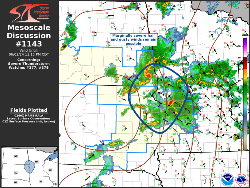
STATUS REPORT #3 ON WW 377
VALID 022345Z - 030040Z
THE SEVERE WEATHER THREAT CONTINUES ACROSS THE ENTIRE WATCH AREA.
FOR ADDITIONAL INFORMATION SEE MESOSCALE DISCUSSION 1136
..SUPINIE..06/02/24
ATTN...WFO...BIS...FGF...ABR...UNR...
&&
STATUS REPORT FOR WS 377
SEVERE WEATHER THREAT CONTINUES FOR THE FOLLOWING AREAS
NDC001-003-015-017-021-025-027-029-031-035-037-039-041-043-045-
047-051-055-057-059-063-065-073-077-081-083-085-089-091-093-097-
103-030040-
ND
. NORTH DAKOTA COUNTIES INCLUDED ARE
ADAMS BARNES BURLEIGH
CASS DICKEY DUNN
EDDY EMMONS FOSTER
GRAND FORKS GRANT GRIGGS
HETTINGER KIDDER LAMOURE
LOGAN MCINTOSH MCLEAN
MERCER MORTON NELSON
OLIVER RANSOM RICHLAND
SARGENT SHERIDAN SIOUX
STARK STEELE STUTSMAN
TRAILL WELLS
$$
SDC013-021-031-041-045-055-089-093-105-107-129-137-030040-
SD
. SOUTH DAKOTA COUNTIES INCLUDED ARE
BROWN CAMPBELL CORSON
DEWEY EDMUNDS HAAKON
MCPHERSON MEADE PERKINS
POTTER WALWORTH ZIEBACH
$$
THE WATCH STATUS MESSAGE IS FOR GUIDANCE PURPOSES ONLY. PLEASE
REFER TO WATCH COUNTY NOTIFICATION STATEMENTS FOR OFFICIAL
INFORMATION ON COUNTIES...INDEPENDENT CITIES AND MARINE ZONES
CLEARED FROM SEVERE THUNDERSTORM AND TORNADO WATCHES.
$$
STATUS REPORT #2 ON WW 377
VALID 022245Z - 022340Z
THE SEVERE WEATHER THREAT CONTINUES ACROSS THE ENTIRE WATCH AREA.
..SUPINIE..06/02/24
ATTN...WFO...BIS...FGF...ABR...UNR...
&&
STATUS REPORT FOR WS 377
SEVERE WEATHER THREAT CONTINUES FOR THE FOLLOWING AREAS
NDC001-003-015-017-021-025-027-029-031-035-037-039-041-043-045-
047-051-055-057-059-063-065-073-077-081-083-085-089-091-093-097-
103-022340-
ND
. NORTH DAKOTA COUNTIES INCLUDED ARE
ADAMS BARNES BURLEIGH
CASS DICKEY DUNN
EDDY EMMONS FOSTER
GRAND FORKS GRANT GRIGGS
HETTINGER KIDDER LAMOURE
LOGAN MCINTOSH MCLEAN
MERCER MORTON NELSON
OLIVER RANSOM RICHLAND
SARGENT SHERIDAN SIOUX
STARK STEELE STUTSMAN
TRAILL WELLS
$$
SDC013-021-031-041-045-055-089-093-105-107-129-137-022340-
SD
. SOUTH DAKOTA COUNTIES INCLUDED ARE
BROWN CAMPBELL CORSON
DEWEY EDMUNDS HAAKON
MCPHERSON MEADE PERKINS
POTTER WALWORTH ZIEBACH
$$
THE WATCH STATUS MESSAGE IS FOR GUIDANCE PURPOSES ONLY. PLEASE
REFER TO WATCH COUNTY NOTIFICATION STATEMENTS FOR OFFICIAL
INFORMATION ON COUNTIES...INDEPENDENT CITIES AND MARINE ZONES
CLEARED FROM SEVERE THUNDERSTORM AND TORNADO WATCHES.
$$
STATUS REPORT #1 ON WW 377
VALID 022145Z - 022240Z
THE SEVERE WEATHER THREAT CONTINUES ACROSS THE ENTIRE WATCH AREA.
..SUPINIE..06/02/24
ATTN...WFO...BIS...FGF...ABR...UNR...
&&
STATUS REPORT FOR WS 377
SEVERE WEATHER THREAT CONTINUES FOR THE FOLLOWING AREAS
NDC001-003-015-017-021-025-027-029-031-035-037-039-041-043-045-
047-051-055-057-059-063-065-073-077-081-083-085-089-091-093-097-
103-022240-
ND
. NORTH DAKOTA COUNTIES INCLUDED ARE
ADAMS BARNES BURLEIGH
CASS DICKEY DUNN
EDDY EMMONS FOSTER
GRAND FORKS GRANT GRIGGS
HETTINGER KIDDER LAMOURE
LOGAN MCINTOSH MCLEAN
MERCER MORTON NELSON
OLIVER RANSOM RICHLAND
SARGENT SHERIDAN SIOUX
STARK STEELE STUTSMAN
TRAILL WELLS
$$
SDC013-021-031-041-045-055-089-093-105-107-129-137-022240-
SD
. SOUTH DAKOTA COUNTIES INCLUDED ARE
BROWN CAMPBELL CORSON
DEWEY EDMUNDS HAAKON
MCPHERSON MEADE PERKINS
POTTER WALWORTH ZIEBACH
$$
THE WATCH STATUS MESSAGE IS FOR GUIDANCE PURPOSES ONLY. PLEASE
REFER TO WATCH COUNTY NOTIFICATION STATEMENTS FOR OFFICIAL
INFORMATION ON COUNTIES...INDEPENDENT CITIES AND MARINE ZONES
CLEARED FROM SEVERE THUNDERSTORM AND TORNADO WATCHES.
$$
Note:
Click for Complete Product Text.
Tornadoes
Probability of 2 or more tornadoes
|
Low (10%)
|
Probability of 1 or more strong (EF2-EF5) tornadoes
|
Low (<2%)
|
Wind
Probability of 10 or more severe wind events
|
Mod (40%)
|
Probability of 1 or more wind events > 65 knots
|
Low (10%)
|
Hail
Probability of 10 or more severe hail events
|
Mod (60%)
|
Probability of 1 or more hailstones > 2 inches
|
Mod (30%)
|
Combined Severe Hail/Wind
Probability of 6 or more combined severe hail/wind events
|
High (80%)
|
For each watch, probabilities for particular events inside the watch
(listed above in each table) are determined by the issuing forecaster.
The "Low" category contains probability values ranging from less than 2%
to 20% (EF2-EF5 tornadoes), less than 5% to 20% (all other probabilities),
"Moderate" from 30% to 60%, and "High" from 70% to greater than 95%.
High values are bolded and lighter in color to provide awareness of
an increased threat for a particular event.


 @NWSSPC