 Note:
The expiration time in the watch graphic is amended if the watch is
replaced, cancelled or extended.
Note:
Note:
The expiration time in the watch graphic is amended if the watch is
replaced, cancelled or extended.
Note: Click for
Watch Status Reports.
SEL0
URGENT - IMMEDIATE BROADCAST REQUESTED
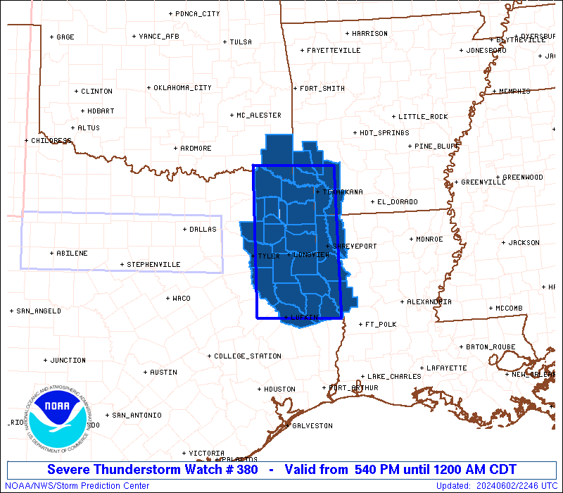
Severe Thunderstorm Watch Number 380
NWS Storm Prediction Center Norman OK
540 PM CDT Sun Jun 2 2024
The NWS Storm Prediction Center has issued a
* Severe Thunderstorm Watch for portions of
Southwest Arkansas
Northwest Louisiana
Southeast Oklahoma
Northeast Texas
* Effective this Sunday afternoon from 540 PM until Midnight CDT.
* Primary threats include...
Isolated very large hail events to 2 inches in diameter possible
Isolated damaging wind gusts to 70 mph possible
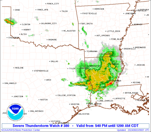
SUMMARY...A line of thunderstorms will track southeastward across
the watch area through the evening, posing a risk of locally
damaging wind gusts and hail.
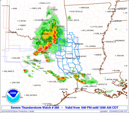
The severe thunderstorm watch area is approximately along and 95
statute miles north and south of a line from 40 miles west northwest
of Longview TX to 15 miles east northeast of Shreveport LA. For a
complete depiction of the watch see the associated watch outline
update (WOUS64 KWNS WOU0).
PRECAUTIONARY/PREPAREDNESS ACTIONS...
REMEMBER...A Severe Thunderstorm Watch means conditions are
favorable for severe thunderstorms in and close to the watch area.
Persons in these areas should be on the lookout for threatening
weather conditions and listen for later statements and possible
warnings. Severe thunderstorms can and occasionally do produce
tornadoes.
&&
OTHER WATCH INFORMATION...CONTINUE...WW 373...WW 374...WW
375...WW 376...WW 377...WW 378...WW 379...
AVIATION...A few severe thunderstorms with hail surface and aloft to
2 inches. Extreme turbulence and surface wind gusts to 60 knots. A
few cumulonimbi with maximum tops to 500. Mean storm motion vector
29030.
...Hart
   SEL0

   URGENT - IMMEDIATE BROADCAST REQUESTED
   Severe Thunderstorm Watch Number 380
   NWS Storm Prediction Center Norman OK
   540 PM CDT Sun Jun 2 2024

   The NWS Storm Prediction Center has issued a

   * Severe Thunderstorm Watch for portions of
     Southwest Arkansas
     Northwest Louisiana
     Southeast Oklahoma
     Northeast Texas

   * Effective this Sunday afternoon from 540 PM until Midnight CDT.

   * Primary threats include...
     Isolated very large hail events to 2 inches in diameter possible
     Isolated damaging wind gusts to 70 mph possible

   SUMMARY...A line of thunderstorms will track southeastward across
   the watch area through the evening, posing a risk of locally
   damaging wind gusts and hail.

   The severe thunderstorm watch area is approximately along and 95
   statute miles north and south of a line from 40 miles west northwest
   of Longview TX to 15 miles east northeast of Shreveport LA. For a
   complete depiction of the watch see the associated watch outline
   update (WOUS64 KWNS WOU0).

   PRECAUTIONARY/PREPAREDNESS ACTIONS...

   REMEMBER...A Severe Thunderstorm Watch means conditions are
   favorable for severe thunderstorms in and close to the watch area.
   Persons in these areas should be on the lookout for threatening
   weather conditions and listen for later statements and possible
   warnings. Severe thunderstorms can and occasionally do produce
   tornadoes.

   &&

   OTHER WATCH INFORMATION...CONTINUE...WW 373...WW 374...WW
   375...WW 376...WW 377...WW 378...WW 379...

   AVIATION...A few severe thunderstorms with hail surface and aloft to
   2 inches. Extreme turbulence and surface wind gusts to 60 knots. A
   few cumulonimbi with maximum tops to 500. Mean storm motion vector
   29030.

   ...Hart
 Note:
The Aviation Watch (SAW) product is an approximation to the watch area.
The actual watch is depicted by the shaded areas.
Note:
The Aviation Watch (SAW) product is an approximation to the watch area.
The actual watch is depicted by the shaded areas.
   SAW0
   WW 380 SEVERE TSTM AR LA OK TX 022240Z - 030500Z
   AXIS..95 STATUTE MILES NORTH AND SOUTH OF LINE..
   40WNW GGG/LONGVIEW TX/ - 15ENE SHV/SHREVEPORT LA/
   ..AVIATION COORDS.. 80NM N/S /32WNW GGG - 18SE EIC/
   HAIL SURFACE AND ALOFT..2 INCHES. WIND GUSTS..60 KNOTS.
   MAX TOPS TO 500. MEAN STORM MOTION VECTOR 29030.

   LAT...LON 33979535 33919359 31169359 31239535

   THIS IS AN APPROXIMATION TO THE WATCH AREA.  FOR A
   COMPLETE DEPICTION OF THE WATCH SEE WOUS64 KWNS
   FOR WOU0.
Watch 380 Status Report Messages:
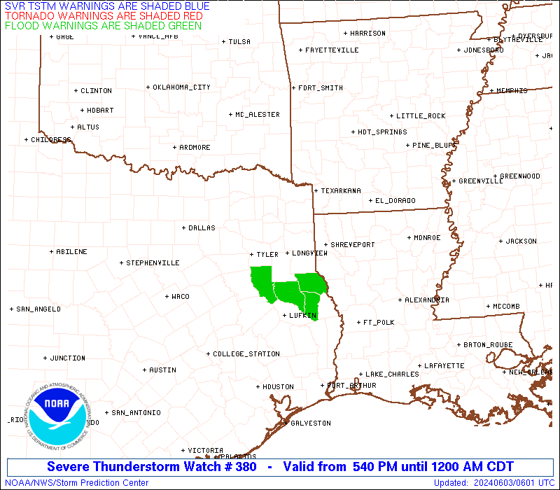
STATUS REPORT #4 ON WW 380

VALID 030455Z - 030540Z

SEVERE WEATHER THREAT CONTINUES RIGHT OF A LINE FROM 50 SSW TYR
TO 35 SW SHV TO 20 ENE SHV.

..BROYLES..06/03/24

ATTN...WFO...SHV...

&&

STATUS REPORT FOR WS 380

SEVERE WEATHER THREAT CONTINUES FOR THE FOLLOWING AREAS

ARC139-030540-

AR
.    ARKANSAS COUNTIES INCLUDED ARE

UNION
$$


LAC013-021-027-031-043-049-059-061-073-081-085-111-127-030540-

LA
.    LOUISIANA PARISHES INCLUDED ARE

BIENVILLE	     CALDWELL		 CLAIBORNE
DE SOTO 	     GRANT		 JACKSON
LA SALLE	     LINCOLN		 OUACHITA
RED RIVER	     SABINE		 UNION
WINN
$$


TXC005-073-347-403-405-419-030540-

TX
.    TEXAS COUNTIES INCLUDED ARE

ANGELINA	     CHEROKEE		 NACOGDOCHES
SABINE		     SAN AUGUSTINE	 SHELBY
$$


THE WATCH STATUS MESSAGE IS FOR GUIDANCE PURPOSES ONLY.  PLEASE
REFER TO WATCH COUNTY NOTIFICATION STATEMENTS FOR OFFICIAL
INFORMATION ON COUNTIES...INDEPENDENT CITIES AND MARINE ZONES
CLEARED FROM SEVERE THUNDERSTORM AND TORNADO WATCHES.
$$

STATUS REPORT #3 ON WW 380

VALID 030140Z - 030240Z

SEVERE WEATHER THREAT CONTINUES RIGHT OF A LINE FROM 15 NNW TYR
TO 35 N GGG TO 25 SW TXK TO 5 ESE DEQ.

..BROYLES..06/03/24

ATTN...WFO...SHV...

&&

STATUS REPORT FOR WS 380

SEVERE WEATHER THREAT CONTINUES FOR THE FOLLOWING AREAS

ARC057-061-073-081-091-133-030240-

AR
.    ARKANSAS COUNTIES INCLUDED ARE

HEMPSTEAD	     HOWARD		 LAFAYETTE
LITTLE RIVER	     MILLER		 SEVIER
$$


LAC015-017-031-085-030240-

LA
.    LOUISIANA PARISHES INCLUDED ARE

BOSSIER 	     CADDO		 DE SOTO
SABINE
$$


TXC005-067-073-183-203-315-347-365-401-403-405-419-423-459-
030240-

TX
.    TEXAS COUNTIES INCLUDED ARE

ANGELINA	     CASS		 CHEROKEE
GREGG		     HARRISON		 MARION
NACOGDOCHES	     PANOLA		 RUSK
SABINE		     SAN AUGUSTINE	 SHELBY
SMITH		     UPSHUR
$$


THE WATCH STATUS MESSAGE IS FOR GUIDANCE PURPOSES ONLY.  PLEASE
REFER TO WATCH COUNTY NOTIFICATION STATEMENTS FOR OFFICIAL
INFORMATION ON COUNTIES...INDEPENDENT CITIES AND MARINE ZONES
CLEARED FROM SEVERE THUNDERSTORM AND TORNADO WATCHES.
$$

STATUS REPORT #2 ON WW 380

VALID 030050Z - 030140Z

SEVERE WEATHER THREAT CONTINUES RIGHT OF A LINE FROM 30 NNW TYR
TO 35 SE PRX TO 35 W DEQ.

..SUPINIE..06/03/24

ATTN...WFO...SHV...

&&

STATUS REPORT FOR WS 380

SEVERE WEATHER THREAT CONTINUES FOR THE FOLLOWING AREAS

ARC057-061-073-081-091-133-030140-

AR
.    ARKANSAS COUNTIES INCLUDED ARE

HEMPSTEAD	     HOWARD		 LAFAYETTE
LITTLE RIVER	     MILLER		 SEVIER
$$


LAC015-017-031-085-030140-

LA
.    LOUISIANA PARISHES INCLUDED ARE

BOSSIER 	     CADDO		 DE SOTO
SABINE
$$


OKC089-030140-

OK
.    OKLAHOMA COUNTIES INCLUDED ARE

MCCURTAIN
$$


TXC005-037-063-067-073-183-203-315-343-347-365-401-403-405-419-
423-449-459-499-030140-

TX
.    TEXAS COUNTIES INCLUDED ARE

ANGELINA	     BOWIE		 CAMP
CASS		     CHEROKEE		 GREGG
HARRISON	     MARION		 MORRIS
NACOGDOCHES	     PANOLA		 RUSK
SABINE		     SAN AUGUSTINE	 SHELBY
SMITH		     TITUS		 UPSHUR
WOOD
$$


THE WATCH STATUS MESSAGE IS FOR GUIDANCE PURPOSES ONLY.  PLEASE
REFER TO WATCH COUNTY NOTIFICATION STATEMENTS FOR OFFICIAL
INFORMATION ON COUNTIES...INDEPENDENT CITIES AND MARINE ZONES
CLEARED FROM SEVERE THUNDERSTORM AND TORNADO WATCHES.
$$

STATUS REPORT #1 ON WW 380

VALID 022350Z - 030040Z

THE SEVERE WEATHER THREAT CONTINUES ACROSS THE ENTIRE WATCH AREA.

..SUPINIE..06/02/24

ATTN...WFO...SHV...

&&

STATUS REPORT FOR WS 380

SEVERE WEATHER THREAT CONTINUES FOR THE FOLLOWING AREAS

ARC057-061-073-081-091-133-030040-

AR
.    ARKANSAS COUNTIES INCLUDED ARE

HEMPSTEAD	     HOWARD		 LAFAYETTE
LITTLE RIVER	     MILLER		 SEVIER
$$


LAC015-017-031-085-030040-

LA
.    LOUISIANA PARISHES INCLUDED ARE

BOSSIER 	     CADDO		 DE SOTO
SABINE
$$


OKC089-030040-

OK
.    OKLAHOMA COUNTIES INCLUDED ARE

MCCURTAIN
$$


TXC005-037-063-067-073-159-183-203-315-343-347-365-387-401-403-
405-419-423-449-459-499-030040-

TX
.    TEXAS COUNTIES INCLUDED ARE

ANGELINA	     BOWIE		 CAMP
CASS		     CHEROKEE		 FRANKLIN
GREGG		     HARRISON		 MARION
MORRIS		     NACOGDOCHES	 PANOLA
RED RIVER	     RUSK		 SABINE
SAN AUGUSTINE	     SHELBY		 SMITH
TITUS		     UPSHUR		 WOOD
$$


THE WATCH STATUS MESSAGE IS FOR GUIDANCE PURPOSES ONLY.  PLEASE
REFER TO WATCH COUNTY NOTIFICATION STATEMENTS FOR OFFICIAL
INFORMATION ON COUNTIES...INDEPENDENT CITIES AND MARINE ZONES
CLEARED FROM SEVERE THUNDERSTORM AND TORNADO WATCHES.
$$
Note:
Click for Complete Product Text.
Tornadoes
Probability of 2 or more tornadoes
|
Low (<5%)
|
Probability of 1 or more strong (EF2-EF5) tornadoes
|
Low (<2%)
|
Wind
Probability of 10 or more severe wind events
|
Mod (30%)
|
Probability of 1 or more wind events > 65 knots
|
Low (10%)
|
Hail
Probability of 10 or more severe hail events
|
Mod (30%)
|
Probability of 1 or more hailstones > 2 inches
|
Mod (30%)
|
Combined Severe Hail/Wind
Probability of 6 or more combined severe hail/wind events
|
Mod (60%)
|
For each watch, probabilities for particular events inside the watch
(listed above in each table) are determined by the issuing forecaster.
The "Low" category contains probability values ranging from less than 2%
to 20% (EF2-EF5 tornadoes), less than 5% to 20% (all other probabilities),
"Moderate" from 30% to 60%, and "High" from 70% to greater than 95%.
High values are bolded and lighter in color to provide awareness of
an increased threat for a particular event.


 @NWSSPC