Note:
The expiration time in the watch graphic is amended if the watch is
replaced, cancelled or extended.
Note:
Note:
The expiration time in the watch graphic is amended if the watch is
replaced, cancelled or extended.
Note: Click for
Watch Status Reports.
SEL9
URGENT - IMMEDIATE BROADCAST REQUESTED
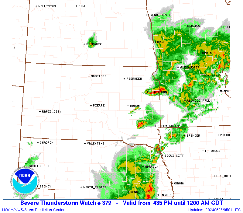
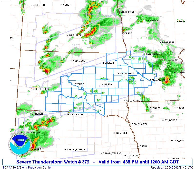
Severe Thunderstorm Watch Number 379
NWS Storm Prediction Center Norman OK
435 PM CDT Sun Jun 2 2024
The NWS Storm Prediction Center has issued a
* Severe Thunderstorm Watch for portions of
Southwest Minnesota
Central and Eastern South Dakota
* Effective this Sunday afternoon from 435 PM until Midnight CDT.
* Primary threats include...
Scattered large hail and isolated very large hail events to 2.5
inches in diameter likely
Scattered damaging wind gusts to 70 mph likely
A tornado or two possible
SUMMARY...Several areas of thunderstorms will develop and spread
across the watch area this afternoon and evening. Large hail and
damaging winds are the main threats, although an isolated tornado is
also possible.
The severe thunderstorm watch area is approximately along and 70
statute miles north and south of a line from 55 miles southwest of
Pierre SD to 55 miles east southeast of Ortonville MN. For a
complete depiction of the watch see the associated watch outline
update (WOUS64 KWNS WOU9).
PRECAUTIONARY/PREPAREDNESS ACTIONS...
REMEMBER...A Severe Thunderstorm Watch means conditions are
favorable for severe thunderstorms in and close to the watch area.
Persons in these areas should be on the lookout for threatening
weather conditions and listen for later statements and possible
warnings. Severe thunderstorms can and occasionally do produce
tornadoes.
&&
OTHER WATCH INFORMATION...CONTINUE...WW 372...WW 373...WW
374...WW 375...WW 376...WW 377...WW 378...
AVIATION...A few severe thunderstorms with hail surface and aloft to
2.5 inches. Extreme turbulence and surface wind gusts to 60 knots. A
few cumulonimbi with maximum tops to 500. Mean storm motion vector
27030.
...Hart

   SEL9

   URGENT - IMMEDIATE BROADCAST REQUESTED
   Severe Thunderstorm Watch Number 379
   NWS Storm Prediction Center Norman OK
   435 PM CDT Sun Jun 2 2024

   The NWS Storm Prediction Center has issued a

   * Severe Thunderstorm Watch for portions of
     Southwest Minnesota
     Central and Eastern South Dakota

   * Effective this Sunday afternoon from 435 PM until Midnight CDT.

   * Primary threats include...
     Scattered large hail and isolated very large hail events to 2.5
       inches in diameter likely
     Scattered damaging wind gusts to 70 mph likely
     A tornado or two possible

   SUMMARY...Several areas of thunderstorms will develop and spread
   across the watch area this afternoon and evening.  Large hail and
   damaging winds are the main threats, although an isolated tornado is
   also possible.

   The severe thunderstorm watch area is approximately along and 70
   statute miles north and south of a line from 55 miles southwest of
   Pierre SD to 55 miles east southeast of Ortonville MN. For a
   complete depiction of the watch see the associated watch outline
   update (WOUS64 KWNS WOU9).

   PRECAUTIONARY/PREPAREDNESS ACTIONS...

   REMEMBER...A Severe Thunderstorm Watch means conditions are
   favorable for severe thunderstorms in and close to the watch area.
   Persons in these areas should be on the lookout for threatening
   weather conditions and listen for later statements and possible
   warnings. Severe thunderstorms can and occasionally do produce
   tornadoes.

   &&

   OTHER WATCH INFORMATION...CONTINUE...WW 372...WW 373...WW
   374...WW 375...WW 376...WW 377...WW 378...

   AVIATION...A few severe thunderstorms with hail surface and aloft to
   2.5 inches. Extreme turbulence and surface wind gusts to 60 knots. A
   few cumulonimbi with maximum tops to 500. Mean storm motion vector
   27030.

   ...Hart
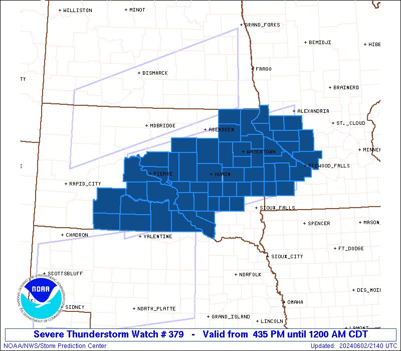
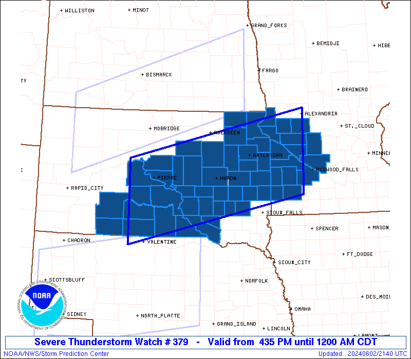
 Note:
The Aviation Watch (SAW) product is an approximation to the watch area.
The actual watch is depicted by the shaded areas.
Note:
The Aviation Watch (SAW) product is an approximation to the watch area.
The actual watch is depicted by the shaded areas.
   SAW9
   WW 379 SEVERE TSTM MN SD 022135Z - 030500Z
   AXIS..70 STATUTE MILES NORTH AND SOUTH OF LINE..
   55SW PIR/PIERRE SD/ - 55ESE VVV/ORTONVILLE MN/
   ..AVIATION COORDS.. 60NM N/S /52SW PIR - 34NNW RWF/
   HAIL SURFACE AND ALOFT..2.5 INCHES. WIND GUSTS..60 KNOTS.
   MAX TOPS TO 500. MEAN STORM MOTION VECTOR 27030.

   LAT...LON 44830106 46019538 43999538 42800106

   THIS IS AN APPROXIMATION TO THE WATCH AREA.  FOR A
   COMPLETE DEPICTION OF THE WATCH SEE WOUS64 KWNS
   FOR WOU9.
Watch 379 Status Report Messages:
STATUS REPORT #4 ON WW 379

VALID 030145Z - 030240Z

SEVERE WEATHER THREAT CONTINUES RIGHT OF A LINE FROM 35 NW VTN TO
15 WSW HON TO 20 E ABR.

..SPC..06/03/24

ATTN...WFO...ABR...MPX...FSD...UNR...

&&

STATUS REPORT FOR WS 379

SEVERE WEATHER THREAT CONTINUES FOR THE FOLLOWING AREAS

MNC011-023-067-073-081-083-101-117-121-127-129-149-151-155-173-
030240-

MN
.    MINNESOTA COUNTIES INCLUDED ARE

BIG STONE	     CHIPPEWA		 KANDIYOHI
LAC QUI PARLE	     LINCOLN		 LYON
MURRAY		     PIPESTONE		 POPE
REDWOOD 	     RENVILLE		 STEVENS
SWIFT		     TRAVERSE		 YELLOW MEDICINE
$$


SDC003-005-011-015-023-025-029-035-037-039-043-051-053-057-061-
073-077-079-087-091-097-101-109-111-115-121-123-030240-

SD
.    SOUTH DAKOTA COUNTIES INCLUDED ARE

AURORA		     BEADLE		 BROOKINGS
BRULE		     CHARLES MIX	 CLARK
CODINGTON	     DAVISON		 DAY
DEUEL		     DOUGLAS		 GRANT
GREGORY 	     HAMLIN		 HANSON
JERAULD 	     KINGSBURY		 LAKE
MCCOOK		     MARSHALL		 MINER
MOODY		     ROBERTS		 SANBORN
SPINK		     TODD		 TRIPP
$$


THE WATCH STATUS MESSAGE IS FOR GUIDANCE PURPOSES ONLY.  PLEASE
REFER TO WATCH COUNTY NOTIFICATION STATEMENTS FOR OFFICIAL
INFORMATION ON COUNTIES...INDEPENDENT CITIES AND MARINE ZONES
CLEARED FROM SEVERE THUNDERSTORM AND TORNADO WATCHES.
$$

STATUS REPORT #3 ON WW 379

VALID 030050Z - 030140Z

THE SEVERE WEATHER THREAT CONTINUES ACROSS THE ENTIRE WATCH AREA.

FOR ADDITIONAL INFORMATION SEE MESOSCALE DISCUSSION 1138

..SUPINIE..06/03/24

ATTN...WFO...ABR...MPX...FSD...UNR...

&&

STATUS REPORT FOR WS 379

SEVERE WEATHER THREAT CONTINUES FOR THE FOLLOWING AREAS

MNC011-023-067-073-081-083-101-117-121-127-129-149-151-155-173-
030140-

MN
.    MINNESOTA COUNTIES INCLUDED ARE

BIG STONE	     CHIPPEWA		 KANDIYOHI
LAC QUI PARLE	     LINCOLN		 LYON
MURRAY		     PIPESTONE		 POPE
REDWOOD 	     RENVILLE		 STEVENS
SWIFT		     TRAVERSE		 YELLOW MEDICINE
$$


SDC003-005-007-011-015-017-023-025-029-035-037-039-043-049-051-
053-057-059-061-065-069-071-073-075-077-079-085-087-091-095-097-
101-109-111-115-117-119-121-123-030140-

SD
.    SOUTH DAKOTA COUNTIES INCLUDED ARE

AURORA		     BEADLE		 BENNETT
BROOKINGS	     BRULE		 BUFFALO
CHARLES MIX	     CLARK		 CODINGTON
DAVISON 	     DAY		 DEUEL
DOUGLAS 	     FAULK		 GRANT
GREGORY 	     HAMLIN		 HAND
HANSON		     HUGHES		 HYDE
JACKSON 	     JERAULD		 JONES
KINGSBURY	     LAKE		 LYMAN
MCCOOK		     MARSHALL		 MELLETTE
MINER		     MOODY		 ROBERTS
SANBORN 	     SPINK		 STANLEY
SULLY		     TODD		 TRIPP
$$


THE WATCH STATUS MESSAGE IS FOR GUIDANCE PURPOSES ONLY.  PLEASE
REFER TO WATCH COUNTY NOTIFICATION STATEMENTS FOR OFFICIAL
INFORMATION ON COUNTIES...INDEPENDENT CITIES AND MARINE ZONES
CLEARED FROM SEVERE THUNDERSTORM AND TORNADO WATCHES.
$$

STATUS REPORT #2 ON WW 379

VALID 022345Z - 030040Z

THE SEVERE WEATHER THREAT CONTINUES ACROSS THE ENTIRE WATCH AREA.

..SUPINIE..06/02/24

ATTN...WFO...ABR...MPX...FSD...UNR...

&&

STATUS REPORT FOR WS 379

SEVERE WEATHER THREAT CONTINUES FOR THE FOLLOWING AREAS

MNC011-023-067-073-081-083-101-117-121-127-129-149-151-155-173-
030040-

MN
.    MINNESOTA COUNTIES INCLUDED ARE

BIG STONE	     CHIPPEWA		 KANDIYOHI
LAC QUI PARLE	     LINCOLN		 LYON
MURRAY		     PIPESTONE		 POPE
REDWOOD 	     RENVILLE		 STEVENS
SWIFT		     TRAVERSE		 YELLOW MEDICINE
$$


SDC003-005-007-011-015-017-023-025-029-035-037-039-043-049-051-
053-057-059-061-065-069-071-073-075-077-079-085-087-091-095-097-
101-109-111-115-117-119-121-123-030040-

SD
.    SOUTH DAKOTA COUNTIES INCLUDED ARE

AURORA		     BEADLE		 BENNETT
BROOKINGS	     BRULE		 BUFFALO
CHARLES MIX	     CLARK		 CODINGTON
DAVISON 	     DAY		 DEUEL
DOUGLAS 	     FAULK		 GRANT
GREGORY 	     HAMLIN		 HAND
HANSON		     HUGHES		 HYDE
JACKSON 	     JERAULD		 JONES
KINGSBURY	     LAKE		 LYMAN
MCCOOK		     MARSHALL		 MELLETTE
MINER		     MOODY		 ROBERTS
SANBORN 	     SPINK		 STANLEY
SULLY		     TODD		 TRIPP
$$


THE WATCH STATUS MESSAGE IS FOR GUIDANCE PURPOSES ONLY.  PLEASE
REFER TO WATCH COUNTY NOTIFICATION STATEMENTS FOR OFFICIAL
INFORMATION ON COUNTIES...INDEPENDENT CITIES AND MARINE ZONES
CLEARED FROM SEVERE THUNDERSTORM AND TORNADO WATCHES.
$$

STATUS REPORT #1 ON WW 379

VALID 022250Z - 022340Z

THE SEVERE WEATHER THREAT CONTINUES ACROSS THE ENTIRE WATCH AREA.

..SUPINIE..06/02/24

ATTN...WFO...ABR...MPX...FSD...UNR...

&&

STATUS REPORT FOR WS 379

SEVERE WEATHER THREAT CONTINUES FOR THE FOLLOWING AREAS

MNC011-023-067-073-081-083-101-117-121-127-129-149-151-155-173-
022340-

MN
.    MINNESOTA COUNTIES INCLUDED ARE

BIG STONE	     CHIPPEWA		 KANDIYOHI
LAC QUI PARLE	     LINCOLN		 LYON
MURRAY		     PIPESTONE		 POPE
REDWOOD 	     RENVILLE		 STEVENS
SWIFT		     TRAVERSE		 YELLOW MEDICINE
$$


SDC003-005-007-011-015-017-023-025-029-035-037-039-043-049-051-
053-057-059-061-065-069-071-073-075-077-079-085-087-091-095-097-
101-109-111-115-117-119-121-123-022340-

SD
.    SOUTH DAKOTA COUNTIES INCLUDED ARE

AURORA		     BEADLE		 BENNETT
BROOKINGS	     BRULE		 BUFFALO
CHARLES MIX	     CLARK		 CODINGTON
DAVISON 	     DAY		 DEUEL
DOUGLAS 	     FAULK		 GRANT
GREGORY 	     HAMLIN		 HAND
HANSON		     HUGHES		 HYDE
JACKSON 	     JERAULD		 JONES
KINGSBURY	     LAKE		 LYMAN
MCCOOK		     MARSHALL		 MELLETTE
MINER		     MOODY		 ROBERTS
SANBORN 	     SPINK		 STANLEY
SULLY		     TODD		 TRIPP
$$


THE WATCH STATUS MESSAGE IS FOR GUIDANCE PURPOSES ONLY.  PLEASE
REFER TO WATCH COUNTY NOTIFICATION STATEMENTS FOR OFFICIAL
INFORMATION ON COUNTIES...INDEPENDENT CITIES AND MARINE ZONES
CLEARED FROM SEVERE THUNDERSTORM AND TORNADO WATCHES.
$$
Note:
Click for Complete Product Text.
Tornadoes
Probability of 2 or more tornadoes
|
Low (20%)
|
Probability of 1 or more strong (EF2-EF5) tornadoes
|
Low (5%)
|
Wind
Probability of 10 or more severe wind events
|
High (70%)
|
Probability of 1 or more wind events > 65 knots
|
Low (20%)
|
Hail
Probability of 10 or more severe hail events
|
High (70%)
|
Probability of 1 or more hailstones > 2 inches
|
Mod (60%)
|
Combined Severe Hail/Wind
Probability of 6 or more combined severe hail/wind events
|
High (>95%)
|
For each watch, probabilities for particular events inside the watch
(listed above in each table) are determined by the issuing forecaster.
The "Low" category contains probability values ranging from less than 2%
to 20% (EF2-EF5 tornadoes), less than 5% to 20% (all other probabilities),
"Moderate" from 30% to 60%, and "High" from 70% to greater than 95%.
High values are bolded and lighter in color to provide awareness of
an increased threat for a particular event.


 @NWSSPC