Note:
The expiration time in the watch graphic is amended if the watch is
replaced, cancelled or extended.
Note:
Note:
The expiration time in the watch graphic is amended if the watch is
replaced, cancelled or extended.
Note: Click for
Watch Status Reports.
SEL3
URGENT - IMMEDIATE BROADCAST REQUESTED
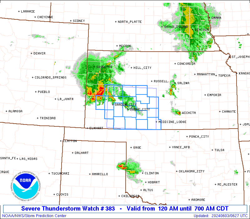
Severe Thunderstorm Watch Number 383
NWS Storm Prediction Center Norman OK
120 AM CDT Mon Jun 3 2024
The NWS Storm Prediction Center has issued a
* Severe Thunderstorm Watch for portions of
Southwest Kansas
* Effective this Monday morning from 120 AM until 700 AM CDT.
* Primary threats include...
Scattered large hail events to 1.5 inches in diameter possible
Isolated damaging wind gusts to 60 mph possible
SUMMARY...Clusters of storms are expected to develop
east-southeastward across southwest Kansas through the early morning
hours, with the primary threat of occasional large hail up to 1.5
inches in diameter. Isolated severe gusts up to 60 mph may also
occur.
The severe thunderstorm watch area is approximately along and 55
statute miles north and south of a line from 15 miles west southwest
of Garden City KS to 35 miles north of Medicine Lodge KS. For a
complete depiction of the watch see the associated watch outline
update (WOUS64 KWNS WOU3).
PRECAUTIONARY/PREPAREDNESS ACTIONS...
REMEMBER...A Severe Thunderstorm Watch means conditions are
favorable for severe thunderstorms in and close to the watch area.
Persons in these areas should be on the lookout for threatening
weather conditions and listen for later statements and possible
warnings. Severe thunderstorms can and occasionally do produce
tornadoes.
&&
AVIATION...A few severe thunderstorms with hail surface and aloft to
1.5 inches. Extreme turbulence and surface wind gusts to 50 knots. A
few cumulonimbi with maximum tops to 500. Mean storm motion vector
30020.
...Thompson

   SEL3

   URGENT - IMMEDIATE BROADCAST REQUESTED
   Severe Thunderstorm Watch Number 383
   NWS Storm Prediction Center Norman OK
   120 AM CDT Mon Jun 3 2024

   The NWS Storm Prediction Center has issued a

   * Severe Thunderstorm Watch for portions of
     Southwest Kansas

   * Effective this Monday morning from 120 AM until 700 AM CDT.

   * Primary threats include...
     Scattered large hail events to 1.5 inches in diameter possible
     Isolated damaging wind gusts to 60 mph possible

   SUMMARY...Clusters of storms are expected to develop
   east-southeastward across southwest Kansas through the early morning
   hours, with the primary threat of occasional large hail up to 1.5
   inches in diameter.  Isolated severe gusts up to 60 mph may also
   occur.

   The severe thunderstorm watch area is approximately along and 55
   statute miles north and south of a line from 15 miles west southwest
   of Garden City KS to 35 miles north of Medicine Lodge KS. For a
   complete depiction of the watch see the associated watch outline
   update (WOUS64 KWNS WOU3).

   PRECAUTIONARY/PREPAREDNESS ACTIONS...

   REMEMBER...A Severe Thunderstorm Watch means conditions are
   favorable for severe thunderstorms in and close to the watch area.
   Persons in these areas should be on the lookout for threatening
   weather conditions and listen for later statements and possible
   warnings. Severe thunderstorms can and occasionally do produce
   tornadoes.

   &&

   AVIATION...A few severe thunderstorms with hail surface and aloft to
   1.5 inches. Extreme turbulence and surface wind gusts to 50 knots. A
   few cumulonimbi with maximum tops to 500. Mean storm motion vector
   30020.

   ...Thompson
 Note:
The Aviation Watch (SAW) product is an approximation to the watch area.
The actual watch is depicted by the shaded areas.
Note:
The Aviation Watch (SAW) product is an approximation to the watch area.
The actual watch is depicted by the shaded areas.
   SAW3
   WW 383 SEVERE TSTM KS 030620Z - 031200Z
   AXIS..55 STATUTE MILES NORTH AND SOUTH OF LINE..
   15WSW GCK/GARDEN CITY KS/ - 35N P28/MEDICINE LODGE KS/
   ..AVIATION COORDS.. 50NM N/S /12WSW GCK - 48W ICT/
   HAIL SURFACE AND ALOFT..1.5 INCHES. WIND GUSTS..50 KNOTS.
   MAX TOPS TO 500. MEAN STORM MOTION VECTOR 30020.

   LAT...LON 38640097 38599858 37009858 37050097

   THIS IS AN APPROXIMATION TO THE WATCH AREA.  FOR A
   COMPLETE DEPICTION OF THE WATCH SEE WOUS64 KWNS
   FOR WOU3.
Watch 383 Status Report Messages:
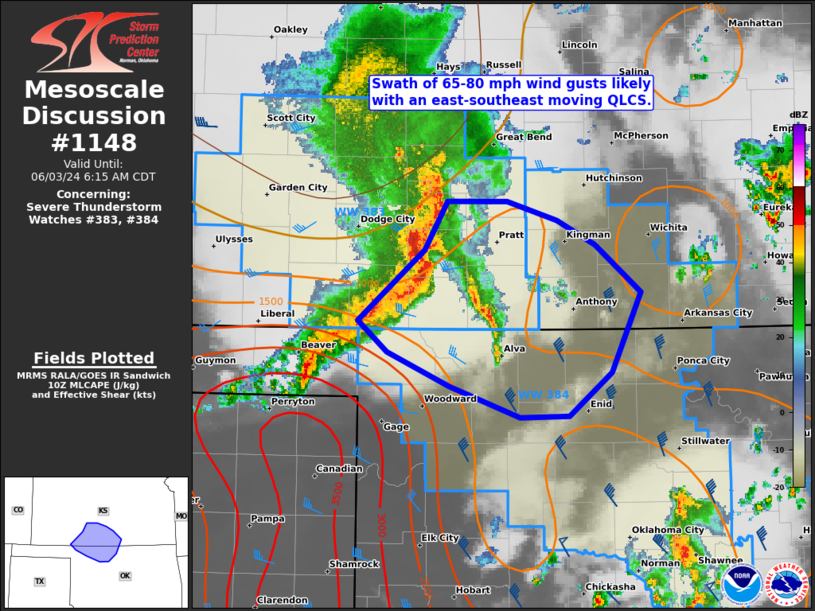
STATUS REPORT #4 ON WW 383

VALID 031030Z - 031140Z

SEVERE WEATHER THREAT CONTINUES RIGHT OF A LINE FROM 35 E LBL TO
25 ENE DDC TO 20 SW RSL.

FOR ADDITIONAL INFORMATION SEE MESOSCALE DISCUSSION 1148.

..GRAMS..06/03/24

ATTN...WFO...DDC...

&&

STATUS REPORT FOR WS 383

SEVERE WEATHER THREAT CONTINUES FOR THE FOLLOWING AREAS

KSC007-025-033-047-097-145-151-185-031140-

KS
.    KANSAS COUNTIES INCLUDED ARE

BARBER		     CLARK		 COMANCHE
EDWARDS 	     KIOWA		 PAWNEE
PRATT		     STAFFORD
$$


THE WATCH STATUS MESSAGE IS FOR GUIDANCE PURPOSES ONLY.  PLEASE
REFER TO WATCH COUNTY NOTIFICATION STATEMENTS FOR OFFICIAL
INFORMATION ON COUNTIES...INDEPENDENT CITIES AND MARINE ZONES
CLEARED FROM SEVERE THUNDERSTORM AND TORNADO WATCHES.
$$

STATUS REPORT #3 ON WW 383

VALID 030935Z - 031040Z

SEVERE WEATHER THREAT CONTINUES RIGHT OF A LINE FROM 15 E LBL TO
20 WSW DDC TO 50 WSW RSL.

..GRAMS..06/03/24

ATTN...WFO...DDC...

&&

STATUS REPORT FOR WS 383

SEVERE WEATHER THREAT CONTINUES FOR THE FOLLOWING AREAS

KSC007-025-033-047-057-083-097-119-145-151-165-185-031040-

KS
.    KANSAS COUNTIES INCLUDED ARE

BARBER		     CLARK		 COMANCHE
EDWARDS 	     FORD		 HODGEMAN
KIOWA		     MEADE		 PAWNEE
PRATT		     RUSH		 STAFFORD
$$


THE WATCH STATUS MESSAGE IS FOR GUIDANCE PURPOSES ONLY.  PLEASE
REFER TO WATCH COUNTY NOTIFICATION STATEMENTS FOR OFFICIAL
INFORMATION ON COUNTIES...INDEPENDENT CITIES AND MARINE ZONES
CLEARED FROM SEVERE THUNDERSTORM AND TORNADO WATCHES.
$$

STATUS REPORT #2 ON WW 383

VALID 030850Z - 030940Z

SEVERE WEATHER THREAT CONTINUES RIGHT OF A LINE FROM 20 SW GCK TO
55 SSW HLC.

FOR ADDITIONAL INFORMATION SEE MESOSCALE DISCUSSION 1147.

..GRAMS..06/03/24

ATTN...WFO...DDC...

&&

STATUS REPORT FOR WS 383

SEVERE WEATHER THREAT CONTINUES FOR THE FOLLOWING AREAS

KSC007-025-033-047-055-057-069-081-083-097-101-119-135-145-151-
165-185-030940-

KS
.    KANSAS COUNTIES INCLUDED ARE

BARBER		     CLARK		 COMANCHE
EDWARDS 	     FINNEY		 FORD
GRAY		     HASKELL		 HODGEMAN
KIOWA		     LANE		 MEADE
NESS		     PAWNEE		 PRATT
RUSH		     STAFFORD
$$


THE WATCH STATUS MESSAGE IS FOR GUIDANCE PURPOSES ONLY.  PLEASE
REFER TO WATCH COUNTY NOTIFICATION STATEMENTS FOR OFFICIAL
INFORMATION ON COUNTIES...INDEPENDENT CITIES AND MARINE ZONES
CLEARED FROM SEVERE THUNDERSTORM AND TORNADO WATCHES.
$$

STATUS REPORT #1 ON WW 383

VALID 030735Z - 030840Z

THE SEVERE WEATHER THREAT CONTINUES ACROSS THE ENTIRE WATCH AREA.

..GRAMS..06/03/24

ATTN...WFO...DDC...

&&

STATUS REPORT FOR WS 383

SEVERE WEATHER THREAT CONTINUES FOR THE FOLLOWING AREAS

KSC007-025-033-047-055-057-069-081-083-093-097-101-119-135-145-
151-165-171-185-030840-

KS
.    KANSAS COUNTIES INCLUDED ARE

BARBER		     CLARK		 COMANCHE
EDWARDS 	     FINNEY		 FORD
GRAY		     HASKELL		 HODGEMAN
KEARNY		     KIOWA		 LANE
MEADE		     NESS		 PAWNEE
PRATT		     RUSH		 SCOTT
STAFFORD
$$


THE WATCH STATUS MESSAGE IS FOR GUIDANCE PURPOSES ONLY.  PLEASE
REFER TO WATCH COUNTY NOTIFICATION STATEMENTS FOR OFFICIAL
INFORMATION ON COUNTIES...INDEPENDENT CITIES AND MARINE ZONES
CLEARED FROM SEVERE THUNDERSTORM AND TORNADO WATCHES.
$$
Note:
Click for Complete Product Text.
Tornadoes
Probability of 2 or more tornadoes
|
Low (10%)
|
Probability of 1 or more strong (EF2-EF5) tornadoes
|
Low (<2%)
|
Wind
Probability of 10 or more severe wind events
|
Mod (30%)
|
Probability of 1 or more wind events > 65 knots
|
Low (<5%)
|
Hail
Probability of 10 or more severe hail events
|
Mod (40%)
|
Probability of 1 or more hailstones > 2 inches
|
Low (10%)
|
Combined Severe Hail/Wind
Probability of 6 or more combined severe hail/wind events
|
Mod (60%)
|
For each watch, probabilities for particular events inside the watch
(listed above in each table) are determined by the issuing forecaster.
The "Low" category contains probability values ranging from less than 2%
to 20% (EF2-EF5 tornadoes), less than 5% to 20% (all other probabilities),
"Moderate" from 30% to 60%, and "High" from 70% to greater than 95%.
High values are bolded and lighter in color to provide awareness of
an increased threat for a particular event.


 @NWSSPC