|
Initial List of Counties in SPC Severe Thunderstorm Watch 474 (WOU)
|
Back to Watch 474
|
 |
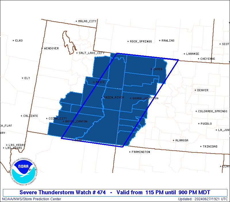
   WOUS64 KWNS 271913
   WOU4

   BULLETIN - IMMEDIATE BROADCAST REQUESTED
   SEVERE THUNDERSTORM WATCH OUTLINE UPDATE FOR WS 474
   NWS STORM PREDICTION CENTER NORMAN OK
   115 PM MDT THU JUN 27 2024

   SEVERE THUNDERSTORM WATCH 474 IS IN EFFECT UNTIL 900 PM MDT
   FOR THE FOLLOWING LOCATIONS

   COC029-033-045-077-081-083-085-091-103-107-113-280300-
   /O.NEW.KWNS.SV.A.0474.240627T1915Z-240628T0300Z/

   CO
   .    COLORADO COUNTIES INCLUDED ARE

   DELTA                DOLORES             GARFIELD
   MESA                 MOFFAT              MONTEZUMA
   MONTROSE             OURAY               RIO BLANCO
   ROUTT                SAN MIGUEL


   UTC007-009-013-015-017-019-025-031-037-041-047-055-280300-
   /O.NEW.KWNS.SV.A.0474.240627T1915Z-240628T0300Z/

   UT
   .    UTAH COUNTIES INCLUDED ARE

   CARBON               DAGGETT             DUCHESNE
   EMERY                GARFIELD            GRAND
   KANE                 PIUTE               SAN JUAN
   SEVIER               UINTAH              WAYNE


   ATTN...WFO...GJT...SLC...
|
| Aviation Watch (SAW) for WW474 |
|---|
 |
| Note:
The Aviation Watch (SAW) product is an approximation to the watch area.
The actual watch is depicted by the shaded areas. |
   SAW4
   WW 474 SEVERE TSTM CO UT 271915Z - 280300Z
   AXIS..95 STATUTE MILES EAST AND WEST OF LINE..
   45SSE U17/BULLFROG MARINA UT/ - 40NNW CAG/CRAIG CO/
   ..AVIATION COORDS.. 85NM E/W /65NE TBC - 38NW CHE/
   HAIL SURFACE AND ALOFT..1.5 INCHES. WIND GUSTS..60 KNOTS.
   MAX TOPS TO 500. MEAN STORM MOTION VECTOR 25025.

   LAT...LON 36931211 41020964 41020599 36930867

   THIS IS AN APPROXIMATION TO THE WATCH AREA.  FOR A
   COMPLETE DEPICTION OF THE WATCH SEE WOUS64 KWNS
   FOR WOU4.
|
|


 @NWSSPC