 Note:
The expiration time in the watch graphic is amended if the watch is
replaced, cancelled or extended.
Note:
Note:
The expiration time in the watch graphic is amended if the watch is
replaced, cancelled or extended.
Note: Click for
Watch Status Reports.
SEL4
URGENT - IMMEDIATE BROADCAST REQUESTED
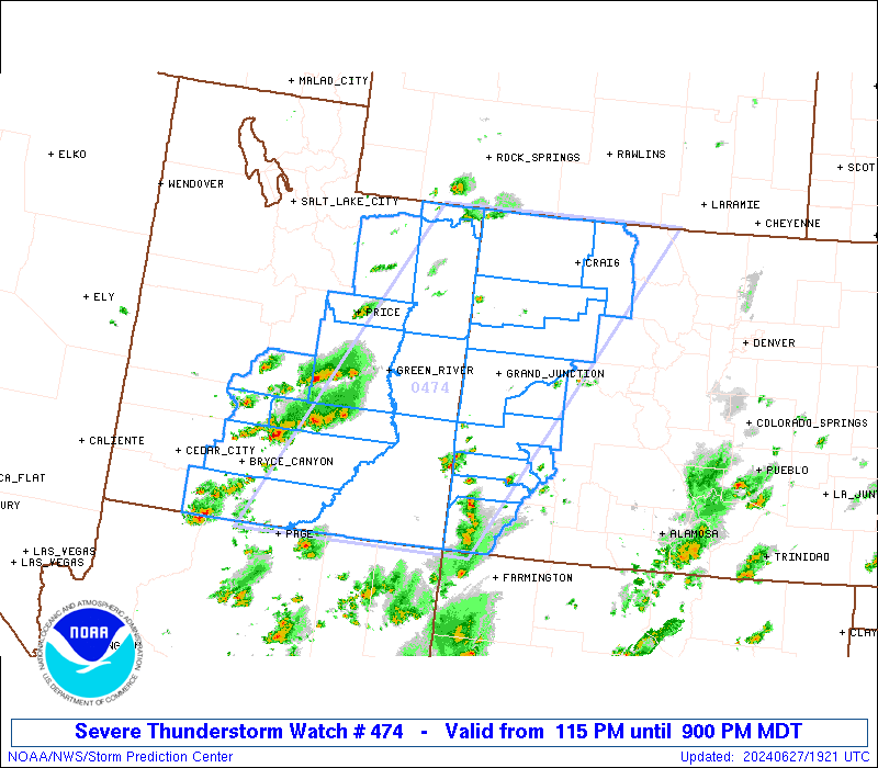
Severe Thunderstorm Watch Number 474
NWS Storm Prediction Center Norman OK
115 PM MDT Thu Jun 27 2024
The NWS Storm Prediction Center has issued a
* Severe Thunderstorm Watch for portions of
Western Colorado
Central and Eastern Utah
* Effective this Thursday afternoon and evening from 115 PM until
900 PM MDT.
* Primary threats include...
Scattered damaging wind gusts to 70 mph possible
Scattered large hail events to 1.5 inches in diameter possible
SUMMARY...Thunderstorms are developing over the higher terrain of
central Utah. This activity will spread eastward through the
afternoon and early evening, posing a risk of a few instances of
large hail and damaging wind gusts.
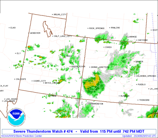
The severe thunderstorm watch area is approximately along and 95
statute miles east and west of a line from 45 miles south southeast
of Bullfrog Marina UT to 40 miles north northwest of Craig CO. For a
complete depiction of the watch see the associated watch outline
update (WOUS64 KWNS WOU4).
PRECAUTIONARY/PREPAREDNESS ACTIONS...
REMEMBER...A Severe Thunderstorm Watch means conditions are
favorable for severe thunderstorms in and close to the watch area.
Persons in these areas should be on the lookout for threatening
weather conditions and listen for later statements and possible
warnings. Severe thunderstorms can and occasionally do produce
tornadoes.
&&
OTHER WATCH INFORMATION...CONTINUE...WW 473...
AVIATION...A few severe thunderstorms with hail surface and aloft to
1.5 inches. Extreme turbulence and surface wind gusts to 60 knots. A
few cumulonimbi with maximum tops to 500. Mean storm motion vector
25025.
...Hart

   SEL4

   URGENT - IMMEDIATE BROADCAST REQUESTED
   Severe Thunderstorm Watch Number 474
   NWS Storm Prediction Center Norman OK
   115 PM MDT Thu Jun 27 2024

   The NWS Storm Prediction Center has issued a

   * Severe Thunderstorm Watch for portions of
     Western Colorado
     Central and Eastern Utah

   * Effective this Thursday afternoon and evening from 115 PM until
     900 PM MDT.

   * Primary threats include...
     Scattered damaging wind gusts to 70 mph possible
     Scattered large hail events to 1.5 inches in diameter possible

   SUMMARY...Thunderstorms are developing over the higher terrain of
   central Utah.  This activity will spread eastward through the
   afternoon and early evening, posing a risk of a few instances of
   large hail and damaging wind gusts.

   The severe thunderstorm watch area is approximately along and 95
   statute miles east and west of a line from 45 miles south southeast
   of Bullfrog Marina UT to 40 miles north northwest of Craig CO. For a
   complete depiction of the watch see the associated watch outline
   update (WOUS64 KWNS WOU4).

   PRECAUTIONARY/PREPAREDNESS ACTIONS...

   REMEMBER...A Severe Thunderstorm Watch means conditions are
   favorable for severe thunderstorms in and close to the watch area.
   Persons in these areas should be on the lookout for threatening
   weather conditions and listen for later statements and possible
   warnings. Severe thunderstorms can and occasionally do produce
   tornadoes.

   &&

   OTHER WATCH INFORMATION...CONTINUE...WW 473...

   AVIATION...A few severe thunderstorms with hail surface and aloft to
   1.5 inches. Extreme turbulence and surface wind gusts to 60 knots. A
   few cumulonimbi with maximum tops to 500. Mean storm motion vector
   25025.

   ...Hart
 Note:
The Aviation Watch (SAW) product is an approximation to the watch area.
The actual watch is depicted by the shaded areas.
Note:
The Aviation Watch (SAW) product is an approximation to the watch area.
The actual watch is depicted by the shaded areas.
   SAW4
   WW 474 SEVERE TSTM CO UT 271915Z - 280300Z
   AXIS..95 STATUTE MILES EAST AND WEST OF LINE..
   45SSE U17/BULLFROG MARINA UT/ - 40NNW CAG/CRAIG CO/
   ..AVIATION COORDS.. 85NM E/W /65NE TBC - 38NW CHE/
   HAIL SURFACE AND ALOFT..1.5 INCHES. WIND GUSTS..60 KNOTS.
   MAX TOPS TO 500. MEAN STORM MOTION VECTOR 25025.

   LAT...LON 36931211 41020964 41020599 36930867

   THIS IS AN APPROXIMATION TO THE WATCH AREA.  FOR A
   COMPLETE DEPICTION OF THE WATCH SEE WOUS64 KWNS
   FOR WOU4.
Watch 474 Status Report Messages:
STATUS REPORT #4 ON WW 474
VALID 272350Z - 280040Z
THE SEVERE WEATHER THREAT CONTINUES ACROSS THE ENTIRE WATCH AREA.
..KARSTENS..06/27/24
ATTN...WFO...GJT...SLC...
&&
STATUS REPORT FOR WS 474
SEVERE WEATHER THREAT CONTINUES FOR THE FOLLOWING AREAS
COC029-033-045-077-081-083-085-091-103-107-113-280040-
CO
. COLORADO COUNTIES INCLUDED ARE
DELTA DOLORES GARFIELD
MESA MOFFAT MONTEZUMA
MONTROSE OURAY RIO BLANCO
ROUTT SAN MIGUEL
$$
UTC007-009-013-015-017-019-025-031-037-041-047-055-280040-
UT
. UTAH COUNTIES INCLUDED ARE
CARBON DAGGETT DUCHESNE
EMERY GARFIELD GRAND
KANE PIUTE SAN JUAN
SEVIER UINTAH WAYNE
$$
THE WATCH STATUS MESSAGE IS FOR GUIDANCE PURPOSES ONLY. PLEASE
REFER TO WATCH COUNTY NOTIFICATION STATEMENTS FOR OFFICIAL
INFORMATION ON COUNTIES...INDEPENDENT CITIES AND MARINE ZONES
CLEARED FROM SEVERE THUNDERSTORM AND TORNADO WATCHES.
$$
STATUS REPORT #3 ON WW 474
VALID 272255Z - 272340Z
THE SEVERE WEATHER THREAT CONTINUES ACROSS THE ENTIRE WATCH AREA.
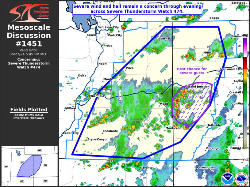
FOR ADDITIONAL INFORMATION SEE MESOSCALE DISCUSSION 1451
..KARSTENS..06/27/24
ATTN...WFO...GJT...SLC...
&&
STATUS REPORT FOR WS 474
SEVERE WEATHER THREAT CONTINUES FOR THE FOLLOWING AREAS
COC029-033-045-077-081-083-085-091-103-107-113-272340-
CO
. COLORADO COUNTIES INCLUDED ARE
DELTA DOLORES GARFIELD
MESA MOFFAT MONTEZUMA
MONTROSE OURAY RIO BLANCO
ROUTT SAN MIGUEL
$$
UTC007-009-013-015-017-019-025-031-037-041-047-055-272340-
UT
. UTAH COUNTIES INCLUDED ARE
CARBON DAGGETT DUCHESNE
EMERY GARFIELD GRAND
KANE PIUTE SAN JUAN
SEVIER UINTAH WAYNE
$$
THE WATCH STATUS MESSAGE IS FOR GUIDANCE PURPOSES ONLY. PLEASE
REFER TO WATCH COUNTY NOTIFICATION STATEMENTS FOR OFFICIAL
INFORMATION ON COUNTIES...INDEPENDENT CITIES AND MARINE ZONES
CLEARED FROM SEVERE THUNDERSTORM AND TORNADO WATCHES.
$$
STATUS REPORT #2 ON WW 474
VALID 272210Z - 272340Z
THE SEVERE WEATHER THREAT CONTINUES ACROSS THE ENTIRE WATCH AREA.
..KARSTENS..06/27/24
ATTN...WFO...GJT...SLC...
&&
STATUS REPORT FOR WS 474
SEVERE WEATHER THREAT CONTINUES FOR THE FOLLOWING AREAS
COC029-033-045-077-081-083-085-091-103-107-113-272340-
CO
. COLORADO COUNTIES INCLUDED ARE
DELTA DOLORES GARFIELD
MESA MOFFAT MONTEZUMA
MONTROSE OURAY RIO BLANCO
ROUTT SAN MIGUEL
$$
UTC007-009-013-015-017-019-025-031-037-041-047-055-272340-
UT
. UTAH COUNTIES INCLUDED ARE
CARBON DAGGETT DUCHESNE
EMERY GARFIELD GRAND
KANE PIUTE SAN JUAN
SEVIER UINTAH WAYNE
$$
THE WATCH STATUS MESSAGE IS FOR GUIDANCE PURPOSES ONLY. PLEASE
REFER TO WATCH COUNTY NOTIFICATION STATEMENTS FOR OFFICIAL
INFORMATION ON COUNTIES...INDEPENDENT CITIES AND MARINE ZONES
CLEARED FROM SEVERE THUNDERSTORM AND TORNADO WATCHES.
$$
STATUS REPORT #1 ON WW 474
VALID 272040Z - 272140Z
THE SEVERE WEATHER THREAT CONTINUES ACROSS THE ENTIRE WATCH AREA.
..JEWELL..06/27/24
ATTN...WFO...GJT...SLC...
&&
STATUS REPORT FOR WS 474
SEVERE WEATHER THREAT CONTINUES FOR THE FOLLOWING AREAS
COC029-033-045-077-081-083-085-091-103-107-113-272140-
CO
. COLORADO COUNTIES INCLUDED ARE
DELTA DOLORES GARFIELD
MESA MOFFAT MONTEZUMA
MONTROSE OURAY RIO BLANCO
ROUTT SAN MIGUEL
$$
UTC007-009-013-015-017-019-025-031-037-041-047-055-272140-
UT
. UTAH COUNTIES INCLUDED ARE
CARBON DAGGETT DUCHESNE
EMERY GARFIELD GRAND
KANE PIUTE SAN JUAN
SEVIER UINTAH WAYNE
$$
THE WATCH STATUS MESSAGE IS FOR GUIDANCE PURPOSES ONLY. PLEASE
REFER TO WATCH COUNTY NOTIFICATION STATEMENTS FOR OFFICIAL
INFORMATION ON COUNTIES...INDEPENDENT CITIES AND MARINE ZONES
CLEARED FROM SEVERE THUNDERSTORM AND TORNADO WATCHES.
$$
Note:
Click for Complete Product Text.
Tornadoes
Probability of 2 or more tornadoes
|
Low (<5%)
|
Probability of 1 or more strong (EF2-EF5) tornadoes
|
Low (<2%)
|
Wind
Probability of 10 or more severe wind events
|
Mod (40%)
|
Probability of 1 or more wind events > 65 knots
|
Low (20%)
|
Hail
Probability of 10 or more severe hail events
|
Mod (40%)
|
Probability of 1 or more hailstones > 2 inches
|
Low (20%)
|
Combined Severe Hail/Wind
Probability of 6 or more combined severe hail/wind events
|
High (70%)
|
For each watch, probabilities for particular events inside the watch
(listed above in each table) are determined by the issuing forecaster.
The "Low" category contains probability values ranging from less than 2%
to 20% (EF2-EF5 tornadoes), less than 5% to 20% (all other probabilities),
"Moderate" from 30% to 60%, and "High" from 70% to greater than 95%.
High values are bolded and lighter in color to provide awareness of
an increased threat for a particular event.


 @NWSSPC