|
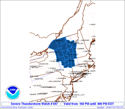
Initial List of Counties in SPC Severe Thunderstorm Watch 547 (WOU)
|
Back to Watch 547
|
 |
   WOUS64 KWNS 161746
   WOU7

   BULLETIN - IMMEDIATE BROADCAST REQUESTED
   SEVERE THUNDERSTORM WATCH OUTLINE UPDATE FOR WS 547
   NWS STORM PREDICTION CENTER NORMAN OK
   150 PM EDT TUE JUL 16 2024

   SEVERE THUNDERSTORM WATCH 547 IS IN EFFECT UNTIL 900 PM EDT
   FOR THE FOLLOWING LOCATIONS

   MAC003-170100-
   /O.NEW.KWNS.SV.A.0547.240716T1750Z-240717T0100Z/

   MA
   .    MASSACHUSETTS COUNTIES INCLUDED ARE

   BERKSHIRE


   NYC001-019-021-031-033-035-039-041-043-057-083-089-091-093-095-
   113-115-170100-
   /O.NEW.KWNS.SV.A.0547.240716T1750Z-240717T0100Z/

   NY
   .    NEW YORK COUNTIES INCLUDED ARE

   ALBANY               CLINTON             COLUMBIA
   ESSEX                FRANKLIN            FULTON
   GREENE               HAMILTON            HERKIMER
   MONTGOMERY           RENSSELAER          SARATOGA
   SCHENECTADY          SCHOHARIE           ST. LAWRENCE
   WARREN               WASHINGTON


   VTC001-003-007-013-017-021-023-025-027-170100-
   /O.NEW.KWNS.SV.A.0547.240716T1750Z-240717T0100Z/

   VT
   .    VERMONT COUNTIES INCLUDED ARE

   ADDISON              BENNINGTON          CHITTENDEN
   GRAND ISLE           ORANGE              RUTLAND
   WASHINGTON           WINDHAM             WINDSOR


   ATTN...WFO...ALY...BTV...
|
| Aviation Watch (SAW) for WW547 |
|---|
 |
| Note:
The Aviation Watch (SAW) product is an approximation to the watch area.
The actual watch is depicted by the shaded areas. |
   SAW7
   WW 547 SEVERE TSTM MA NY VT 161750Z - 170100Z
   AXIS..60 STATUTE MILES EAST AND WEST OF LINE..
   45NNE SLK/SARANAC LAKE NY/ - 30SW PSF/PITTSFIELD MA/
   ..AVIATION COORDS.. 50NM E/W /22NW PLB - 38S ALB/
   HAIL SURFACE AND ALOFT..1.5 INCHES. WIND GUSTS..65 KNOTS.
   MAX TOPS TO 500. MEAN STORM MOTION VECTOR 27030.

   LAT...LON 44977262 42127254 42127487 44977508

   THIS IS AN APPROXIMATION TO THE WATCH AREA.  FOR A
   COMPLETE DEPICTION OF THE WATCH SEE WOUS64 KWNS
   FOR WOU7.
|
|


