Note:
The expiration time in the watch graphic is amended if the watch is
replaced, cancelled or extended.
Note:
Note:
The expiration time in the watch graphic is amended if the watch is
replaced, cancelled or extended.
Note: Click for
Watch Status Reports.
SEL7
URGENT - IMMEDIATE BROADCAST REQUESTED
Severe Thunderstorm Watch Number 547
NWS Storm Prediction Center Norman OK
150 PM EDT Tue Jul 16 2024
The NWS Storm Prediction Center has issued a
* Severe Thunderstorm Watch for portions of
Western Massachusetts
Eastern New York
Central and Southern Vermont
* Effective this Tuesday afternoon and evening from 150 PM until
900 PM EDT.
* Primary threats include...
Scattered damaging winds likely with isolated significant gusts
to 75 mph possible
Isolated large hail events to 1.5 inches in diameter possible
A tornado or two possible
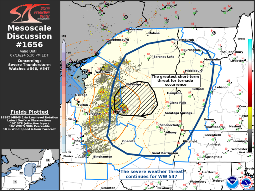
SUMMARY...Thunderstorms over central New York will track quickly
eastward across the watch area this afternoon, posing a risk of
damaging winds.
The severe thunderstorm watch area is approximately along and 60
statute miles east and west of a line from 45 miles north northeast
of Saranac Lake NY to 30 miles southwest of Pittsfield MA. For a
complete depiction of the watch see the associated watch outline
update (WOUS64 KWNS WOU7).
PRECAUTIONARY/PREPAREDNESS ACTIONS...
REMEMBER...A Severe Thunderstorm Watch means conditions are
favorable for severe thunderstorms in and close to the watch area.
Persons in these areas should be on the lookout for threatening
weather conditions and listen for later statements and possible
warnings. Severe thunderstorms can and occasionally do produce
tornadoes.
&&
OTHER WATCH INFORMATION...CONTINUE...WW 546...
AVIATION...A few severe thunderstorms with hail surface and aloft to
1.5 inches. Extreme turbulence and surface wind gusts to 65 knots. A
few cumulonimbi with maximum tops to 500. Mean storm motion vector
27030.
...Hart

   SEL7

   URGENT - IMMEDIATE BROADCAST REQUESTED
   Severe Thunderstorm Watch Number 547
   NWS Storm Prediction Center Norman OK
   150 PM EDT Tue Jul 16 2024

   The NWS Storm Prediction Center has issued a

   * Severe Thunderstorm Watch for portions of
     Western Massachusetts
     Eastern New York
     Central and Southern Vermont

   * Effective this Tuesday afternoon and evening from 150 PM until
     900 PM EDT.

   * Primary threats include...
     Scattered damaging winds likely with isolated significant gusts
       to 75 mph possible
     Isolated large hail events to 1.5 inches in diameter possible
     A tornado or two possible

   SUMMARY...Thunderstorms over central New York will track quickly
   eastward across the watch area this afternoon, posing a risk of
   damaging winds.

   The severe thunderstorm watch area is approximately along and 60
   statute miles east and west of a line from 45 miles north northeast
   of Saranac Lake NY to 30 miles southwest of Pittsfield MA. For a
   complete depiction of the watch see the associated watch outline
   update (WOUS64 KWNS WOU7).

   PRECAUTIONARY/PREPAREDNESS ACTIONS...

   REMEMBER...A Severe Thunderstorm Watch means conditions are
   favorable for severe thunderstorms in and close to the watch area.
   Persons in these areas should be on the lookout for threatening
   weather conditions and listen for later statements and possible
   warnings. Severe thunderstorms can and occasionally do produce
   tornadoes.

   &&

   OTHER WATCH INFORMATION...CONTINUE...WW 546...

   AVIATION...A few severe thunderstorms with hail surface and aloft to
   1.5 inches. Extreme turbulence and surface wind gusts to 65 knots. A
   few cumulonimbi with maximum tops to 500. Mean storm motion vector
   27030.

   ...Hart
 Note:
The Aviation Watch (SAW) product is an approximation to the watch area.
The actual watch is depicted by the shaded areas.
Note:
The Aviation Watch (SAW) product is an approximation to the watch area.
The actual watch is depicted by the shaded areas.
   SAW7
   WW 547 SEVERE TSTM MA NY VT 161750Z - 170100Z
   AXIS..60 STATUTE MILES EAST AND WEST OF LINE..
   45NNE SLK/SARANAC LAKE NY/ - 30SW PSF/PITTSFIELD MA/
   ..AVIATION COORDS.. 50NM E/W /22NW PLB - 38S ALB/
   HAIL SURFACE AND ALOFT..1.5 INCHES. WIND GUSTS..65 KNOTS.
   MAX TOPS TO 500. MEAN STORM MOTION VECTOR 27030.

   LAT...LON 44977262 42127254 42127487 44977508

   THIS IS AN APPROXIMATION TO THE WATCH AREA.  FOR A
   COMPLETE DEPICTION OF THE WATCH SEE WOUS64 KWNS
   FOR WOU7.
Watch 547 Status Report Messages:
STATUS REPORT #2 ON WW 547

VALID 162235Z - 162340Z

SEVERE WEATHER THREAT CONTINUES RIGHT OF A LINE FROM 30 NNW MSV
TO 15 SSW ALB TO 15 N GFL TO 25 S SLK TO 25 WNW MSS.

..MOORE..07/16/24

ATTN...WFO...ALY...BTV...

&&

STATUS REPORT FOR WS 547

SEVERE WEATHER THREAT CONTINUES FOR THE FOLLOWING AREAS

MAC003-162340-

MA
.    MASSACHUSETTS COUNTIES INCLUDED ARE

BERKSHIRE
$$


NYC019-021-031-033-039-083-115-162340-

NY
.    NEW YORK COUNTIES INCLUDED ARE

CLINTON 	     COLUMBIA		 ESSEX
FRANKLIN	     GREENE		 RENSSELAER
WASHINGTON
$$


VTC001-003-007-013-017-021-023-025-027-162340-

VT
.    VERMONT COUNTIES INCLUDED ARE

ADDISON 	     BENNINGTON 	 CHITTENDEN
GRAND ISLE	     ORANGE		 RUTLAND
WASHINGTON	     WINDHAM		 WINDSOR
$$


THE WATCH STATUS MESSAGE IS FOR GUIDANCE PURPOSES ONLY.  PLEASE
REFER TO WATCH COUNTY NOTIFICATION STATEMENTS FOR OFFICIAL
INFORMATION ON COUNTIES...INDEPENDENT CITIES AND MARINE ZONES
CLEARED FROM SEVERE THUNDERSTORM AND TORNADO WATCHES.
$$

STATUS REPORT #1 ON WW 547

VALID 162010Z - 162140Z

THE SEVERE WEATHER THREAT CONTINUES ACROSS THE ENTIRE WATCH AREA.

FOR ADDITIONAL INFORMATION SEE MESOSCALE DISCUSSION 1656

..HALBERT..07/16/24

ATTN...WFO...ALY...BTV...

&&

STATUS REPORT FOR WS 547

SEVERE WEATHER THREAT CONTINUES FOR THE FOLLOWING AREAS

MAC003-162140-

MA
.    MASSACHUSETTS COUNTIES INCLUDED ARE

BERKSHIRE
$$


NYC001-019-021-031-033-035-039-041-043-057-083-089-091-093-095-
113-115-162140-

NY
.    NEW YORK COUNTIES INCLUDED ARE

ALBANY		     CLINTON		 COLUMBIA
ESSEX		     FRANKLIN		 FULTON
GREENE		     HAMILTON		 HERKIMER
MONTGOMERY	     RENSSELAER 	 ST. LAWRENCE
SARATOGA	     SCHENECTADY	 SCHOHARIE
WARREN		     WASHINGTON
$$


VTC001-003-007-013-017-021-023-025-027-162140-

VT
.    VERMONT COUNTIES INCLUDED ARE

ADDISON 	     BENNINGTON 	 CHITTENDEN
GRAND ISLE	     ORANGE		 RUTLAND
WASHINGTON	     WINDHAM		 WINDSOR
$$


THE WATCH STATUS MESSAGE IS FOR GUIDANCE PURPOSES ONLY.  PLEASE
REFER TO WATCH COUNTY NOTIFICATION STATEMENTS FOR OFFICIAL
INFORMATION ON COUNTIES...INDEPENDENT CITIES AND MARINE ZONES
CLEARED FROM SEVERE THUNDERSTORM AND TORNADO WATCHES.
$$
Note:
Click for Complete Product Text.
Tornadoes
Probability of 2 or more tornadoes
|
Low (20%)
|
Probability of 1 or more strong (EF2-EF5) tornadoes
|
Low (<2%)
|
Wind
Probability of 10 or more severe wind events
|
High (70%)
|
Probability of 1 or more wind events > 65 knots
|
Mod (30%)
|
Hail
Probability of 10 or more severe hail events
|
Mod (30%)
|
Probability of 1 or more hailstones > 2 inches
|
Low (20%)
|
Combined Severe Hail/Wind
Probability of 6 or more combined severe hail/wind events
|
High (90%)
|
For each watch, probabilities for particular events inside the watch
(listed above in each table) are determined by the issuing forecaster.
The "Low" category contains probability values ranging from less than 2%
to 20% (EF2-EF5 tornadoes), less than 5% to 20% (all other probabilities),
"Moderate" from 30% to 60%, and "High" from 70% to greater than 95%.
High values are bolded and lighter in color to provide awareness of
an increased threat for a particular event.


 @NWSSPC