|
Initial List of Counties in SPC Tornado Watch 716 (WOU)
|
Back to Watch 716
|
 |
WOUS64 KWNS 270006
WOU6
BULLETIN - IMMEDIATE BROADCAST REQUESTED
TORNADO WATCH OUTLINE UPDATE FOR WT 716
NWS STORM PREDICTION CENTER NORMAN OK
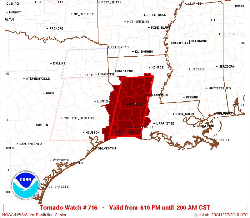
610 PM CST THU DEC 26 2024
TORNADO WATCH 716 IS IN EFFECT UNTIL 200 AM CST FOR THE
FOLLOWING LOCATIONS
LAC001-003-011-019-021-023-039-043-053-059-069-079-081-085-115-
127-270800-
/O.NEW.KWNS.TO.A.0716.241227T0010Z-241227T0800Z/
LA
. LOUISIANA PARISHES INCLUDED ARE
ACADIA ALLEN BEAUREGARD
CALCASIEU CALDWELL CAMERON
EVANGELINE GRANT JEFFERSON DAVIS
LA SALLE NATCHITOCHES RAPIDES
RED RIVER SABINE VERNON
WINN
TXC241-245-351-361-403-270800-
/O.NEW.KWNS.TO.A.0716.241227T0010Z-241227T0800Z/
TX
. TEXAS COUNTIES INCLUDED ARE
JASPER JEFFERSON NEWTON
ORANGE SABINE
GMZ430-432-270800-
/O.NEW.KWNS.TO.A.0716.241227T0010Z-241227T0800Z/
CW
. ADJACENT COASTAL WATERS INCLUDED ARE
SABINE LAKE
CALCASIEU LAKE
ATTN...WFO...LCH...SHV...
|
| Aviation Watch (SAW) for WW716 |
|---|
 |
| Note:
The Aviation Watch (SAW) product is an approximation to the watch area.
The actual watch is depicted by the shaded areas. |
   SAW6
   WW 716 TORNADO LA TX CW 270010Z - 270800Z
   AXIS..45 STATUTE MILES EAST AND WEST OF LINE..
   40NE IER/NATCHITOCHES LA/ - 30SSW LCH/LAKE CHARLES LA/
   ..AVIATION COORDS.. 40NM E/W /37SW MLU - 29SSW LCH/
   HAIL SURFACE AND ALOFT..1.5 INCHES. WIND GUSTS..55 KNOTS.
   MAX TOPS TO 500. MEAN STORM MOTION VECTOR 24035.

   LAT...LON 32159185 29739266 29739416 32159339

   THIS IS AN APPROXIMATION TO THE WATCH AREA.  FOR A
   COMPLETE DEPICTION OF THE WATCH SEE WOUS64 KWNS
   FOR WOU6.
|
|


 @NWSSPC