 Note:
The expiration time in the watch graphic is amended if the watch is
replaced, cancelled or extended.
Note:
Note:
The expiration time in the watch graphic is amended if the watch is
replaced, cancelled or extended.
Note: Click for
Watch Status Reports.
SEL6
URGENT - IMMEDIATE BROADCAST REQUESTED
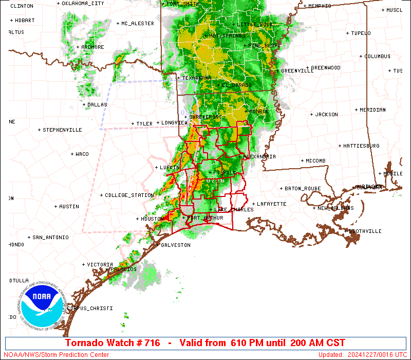
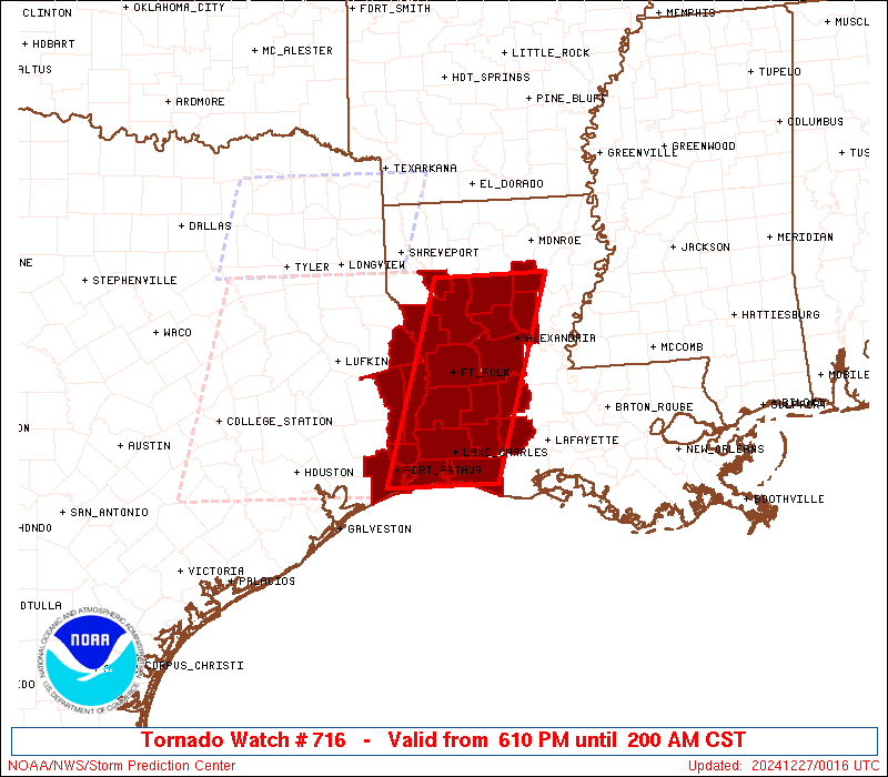
Tornado Watch Number 716
NWS Storm Prediction Center Norman OK
610 PM CST Thu Dec 26 2024
The NWS Storm Prediction Center has issued a
* Tornado Watch for portions of
Western and Central Louisiana
Far Southeast Texas
Coastal Waters
* Effective this Thursday night and Friday morning from 610 PM
until 200 AM CST.
* Primary threats include...
A few tornadoes and a couple intense tornadoes possible
Scattered damaging wind gusts to 65 mph possible
Isolated large hail events to 1.5 inches in diameter possible
SUMMARY...Thunderstorms will continue to pose a threat for a few
tornadoes this evening and into the early overnight hours as they
spread east-northeastward into parts of western and central
Louisiana. Damaging winds up to 60-65 mph and isolated hail may also
occur.
The tornado watch area is approximately along and 45 statute miles
east and west of a line from 40 miles northeast of Natchitoches LA
to 30 miles south southwest of Lake Charles LA. For a complete
depiction of the watch see the associated watch outline update
(WOUS64 KWNS WOU6).
PRECAUTIONARY/PREPAREDNESS ACTIONS...
REMEMBER...A Tornado Watch means conditions are favorable for
tornadoes and severe thunderstorms in and close to the watch
area. Persons in these areas should be on the lookout for
threatening weather conditions and listen for later statements
and possible warnings.
&&
OTHER WATCH INFORMATION...CONTINUE...WW 714...WW 715...
AVIATION...Tornadoes and a few severe thunderstorms with hail
surface and aloft to 1.5 inches. Extreme turbulence and surface wind
gusts to 55 knots. A few cumulonimbi with maximum tops to 500. Mean
storm motion vector 24035.
...Gleason
 Note:
The Aviation Watch (SAW) product is an approximation to the watch area.
The actual watch is depicted by the shaded areas.
Note:
The Aviation Watch (SAW) product is an approximation to the watch area.
The actual watch is depicted by the shaded areas.
   SAW6
   WW 716 TORNADO LA TX CW 270010Z - 270800Z
   AXIS..45 STATUTE MILES EAST AND WEST OF LINE..
   40NE IER/NATCHITOCHES LA/ - 30SSW LCH/LAKE CHARLES LA/
   ..AVIATION COORDS.. 40NM E/W /37SW MLU - 29SSW LCH/
   HAIL SURFACE AND ALOFT..1.5 INCHES. WIND GUSTS..55 KNOTS.
   MAX TOPS TO 500. MEAN STORM MOTION VECTOR 24035.

   LAT...LON 32159185 29739266 29739416 32159339

   THIS IS AN APPROXIMATION TO THE WATCH AREA.  FOR A
   COMPLETE DEPICTION OF THE WATCH SEE WOUS64 KWNS
   FOR WOU6.
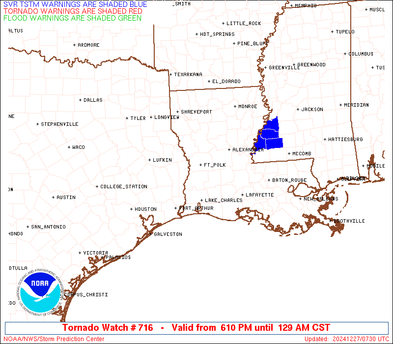
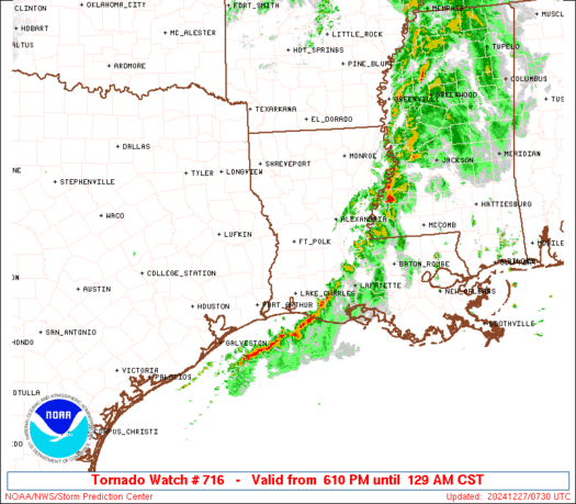
Watch 716 Status Report Messages:
STATUS REPORT #7 ON WW 716

VALID 270640Z - 270800Z

SEVERE WEATHER THREAT CONTINUES RIGHT OF A LINE FROM 25 S LCH TO
35 NW LFT.

WW 716 IS SCHEDULED TO EXPIRE AT 270800Z.

..GRAMS..12/27/24

ATTN...WFO...LCH...SHV...

&&

STATUS REPORT FOR WT 716

SEVERE WEATHER THREAT CONTINUES FOR THE FOLLOWING AREAS

LAC001-023-053-270800-

LA
.    LOUISIANA PARISHES INCLUDED ARE

ACADIA		     CAMERON		 JEFFERSON DAVIS
$$


THE WATCH STATUS MESSAGE IS FOR GUIDANCE PURPOSES ONLY.  PLEASE
REFER TO WATCH COUNTY NOTIFICATION STATEMENTS FOR OFFICIAL
INFORMATION ON COUNTIES...INDEPENDENT CITIES AND MARINE ZONES
CLEARED FROM SEVERE THUNDERSTORM AND TORNADO WATCHES.
$$

STATUS REPORT #6 ON WW 716

VALID 270555Z - 270640Z

SEVERE WEATHER THREAT CONTINUES RIGHT OF A LINE FROM 30 SSW LCH
TO 25 SSE ESF.

..SPC..12/27/24

ATTN...WFO...LCH...SHV...

&&

STATUS REPORT FOR WT 716

SEVERE WEATHER THREAT CONTINUES FOR THE FOLLOWING AREAS

LAC001-009-023-039-053-270640-

LA
.    LOUISIANA PARISHES INCLUDED ARE

ACADIA		     AVOYELLES		 CAMERON
EVANGELINE	     JEFFERSON DAVIS
$$


THE WATCH STATUS MESSAGE IS FOR GUIDANCE PURPOSES ONLY.  PLEASE
REFER TO WATCH COUNTY NOTIFICATION STATEMENTS FOR OFFICIAL
INFORMATION ON COUNTIES...INDEPENDENT CITIES AND MARINE ZONES
CLEARED FROM SEVERE THUNDERSTORM AND TORNADO WATCHES.
$$

STATUS REPORT #5 ON WW 716

VALID 270420Z - 270540Z

SEVERE WEATHER THREAT CONTINUES RIGHT OF A LINE FROM 25 S BPT TO
30 S MLU TO 10 SE MLU.

..THORNTON..12/27/24

ATTN...WFO...LCH...SHV...

&&

STATUS REPORT FOR WT 716

SEVERE WEATHER THREAT CONTINUES FOR THE FOLLOWING AREAS

LAC001-003-009-019-023-039-053-059-079-270540-

LA
.    LOUISIANA PARISHES INCLUDED ARE

ACADIA		     ALLEN		 AVOYELLES
CALCASIEU	     CAMERON		 EVANGELINE
JEFFERSON DAVIS      LA SALLE		 RAPIDES
$$


GMZ432-270540-

CW

.    ADJACENT COASTAL WATERS INCLUDED ARE

CALCASIEU LAKE

$$
THE WATCH STATUS MESSAGE IS FOR GUIDANCE PURPOSES ONLY.  PLEASE
REFER TO WATCH COUNTY NOTIFICATION STATEMENTS FOR OFFICIAL
INFORMATION ON COUNTIES...INDEPENDENT CITIES AND MARINE ZONES
CLEARED FROM SEVERE THUNDERSTORM AND TORNADO WATCHES.
$$

STATUS REPORT #4 ON WW 716

VALID 270325Z - 270440Z

SEVERE WEATHER THREAT CONTINUES RIGHT OF A LINE FROM 25 ENE GLS
TO 20 ESE BPT TO 30 S POE TO 40 WSW MLU.

FOR ADDITIONAL INFORMATION SEE MESOSCALE DISCUSSION 2288

..THORNTON..12/27/24

ATTN...WFO...LCH...SHV...

&&

STATUS REPORT FOR WT 716

SEVERE WEATHER THREAT CONTINUES FOR THE FOLLOWING AREAS

LAC001-003-019-021-023-039-053-059-079-127-270440-

LA
.    LOUISIANA PARISHES INCLUDED ARE

ACADIA		     ALLEN		 CALCASIEU
CALDWELL	     CAMERON		 EVANGELINE
JEFFERSON DAVIS      LA SALLE		 RAPIDES
WINN
$$


GMZ432-270440-

CW

.    ADJACENT COASTAL WATERS INCLUDED ARE

CALCASIEU LAKE

$$
THE WATCH STATUS MESSAGE IS FOR GUIDANCE PURPOSES ONLY.  PLEASE
REFER TO WATCH COUNTY NOTIFICATION STATEMENTS FOR OFFICIAL
INFORMATION ON COUNTIES...INDEPENDENT CITIES AND MARINE ZONES
CLEARED FROM SEVERE THUNDERSTORM AND TORNADO WATCHES.
$$

STATUS REPORT #3 ON WW 716

VALID 270255Z - 270340Z

SEVERE WEATHER THREAT CONTINUES RIGHT OF A LINE FROM 20 NE GLS TO
15 NE BPT TO 5 NW POE TO 45 WSW MLU.

FOR ADDITIONAL INFORMATION SEE MESOSCALE DISCUSSION 2288

..THORNTON..12/27/24

ATTN...WFO...LCH...SHV...

&&

STATUS REPORT FOR WT 716

SEVERE WEATHER THREAT CONTINUES FOR THE FOLLOWING AREAS

LAC001-003-011-019-021-023-039-043-053-059-069-079-127-270340-

LA
.    LOUISIANA PARISHES INCLUDED ARE

ACADIA		     ALLEN		 BEAUREGARD
CALCASIEU	     CALDWELL		 CAMERON
EVANGELINE	     GRANT		 JEFFERSON DAVIS
LA SALLE	     NATCHITOCHES	 RAPIDES
WINN
$$


GMZ430-432-270340-

CW

.    ADJACENT COASTAL WATERS INCLUDED ARE

SABINE LAKE

CALCASIEU LAKE

$$
THE WATCH STATUS MESSAGE IS FOR GUIDANCE PURPOSES ONLY.  PLEASE
REFER TO WATCH COUNTY NOTIFICATION STATEMENTS FOR OFFICIAL
INFORMATION ON COUNTIES...INDEPENDENT CITIES AND MARINE ZONES
CLEARED FROM SEVERE THUNDERSTORM AND TORNADO WATCHES.
$$

STATUS REPORT #2 ON WW 716

VALID 270140Z - 270240Z

SEVERE WEATHER THREAT CONTINUES RIGHT OF A LINE FROM 25 N GLS TO
45 N BPT TO 25 WSW IER TO 45 N IER.

..THORNTON..12/27/24

ATTN...WFO...LCH...SHV...

&&

STATUS REPORT FOR WT 716

SEVERE WEATHER THREAT CONTINUES FOR THE FOLLOWING AREAS

LAC001-003-011-019-021-023-039-043-053-059-069-079-115-127-
270240-

LA
.    LOUISIANA PARISHES INCLUDED ARE

ACADIA		     ALLEN		 BEAUREGARD
CALCASIEU	     CALDWELL		 CAMERON
EVANGELINE	     GRANT		 JEFFERSON DAVIS
LA SALLE	     NATCHITOCHES	 RAPIDES
VERNON		     WINN
$$


TXC245-351-361-270240-

TX
.    TEXAS COUNTIES INCLUDED ARE

JEFFERSON	     NEWTON		 ORANGE
$$


GMZ430-432-270240-

CW

.    ADJACENT COASTAL WATERS INCLUDED ARE

SABINE LAKE

CALCASIEU LAKE

$$
THE WATCH STATUS MESSAGE IS FOR GUIDANCE PURPOSES ONLY.  PLEASE
REFER TO WATCH COUNTY NOTIFICATION STATEMENTS FOR OFFICIAL
INFORMATION ON COUNTIES...INDEPENDENT CITIES AND MARINE ZONES
CLEARED FROM SEVERE THUNDERSTORM AND TORNADO WATCHES.
$$

STATUS REPORT #1 ON WW 716

VALID 270040Z - 270140Z

THE SEVERE WEATHER THREAT CONTINUES ACROSS THE ENTIRE WATCH AREA.

..THORNTON..12/27/24

ATTN...WFO...LCH...SHV...

&&

STATUS REPORT FOR WT 716

SEVERE WEATHER THREAT CONTINUES FOR THE FOLLOWING AREAS

LAC001-003-011-019-021-023-039-043-053-059-069-079-081-085-115-
127-270140-

LA
.    LOUISIANA PARISHES INCLUDED ARE

ACADIA		     ALLEN		 BEAUREGARD
CALCASIEU	     CALDWELL		 CAMERON
EVANGELINE	     GRANT		 JEFFERSON DAVIS
LA SALLE	     NATCHITOCHES	 RAPIDES
RED RIVER	     SABINE		 VERNON
WINN
$$


TXC241-245-351-361-403-270140-

TX
.    TEXAS COUNTIES INCLUDED ARE

JASPER		     JEFFERSON		 NEWTON
ORANGE		     SABINE
$$


GMZ430-432-270140-

CW

.    ADJACENT COASTAL WATERS INCLUDED ARE

SABINE LAKE

CALCASIEU LAKE

$$
THE WATCH STATUS MESSAGE IS FOR GUIDANCE PURPOSES ONLY.  PLEASE
REFER TO WATCH COUNTY NOTIFICATION STATEMENTS FOR OFFICIAL
INFORMATION ON COUNTIES...INDEPENDENT CITIES AND MARINE ZONES
CLEARED FROM SEVERE THUNDERSTORM AND TORNADO WATCHES.
$$
Note:
Click for Complete Product Text.
Tornadoes
Probability of 2 or more tornadoes
|
Mod (50%)
|
Probability of 1 or more strong (EF2-EF5) tornadoes
|
Mod (30%)
|
Wind
Probability of 10 or more severe wind events
|
Mod (40%)
|
Probability of 1 or more wind events > 65 knots
|
Low (10%)
|
Hail
Probability of 10 or more severe hail events
|
Low (20%)
|
Probability of 1 or more hailstones > 2 inches
|
Low (10%)
|
Combined Severe Hail/Wind
Probability of 6 or more combined severe hail/wind events
|
Mod (50%)
|
For each watch, probabilities for particular events inside the watch
(listed above in each table) are determined by the issuing forecaster.
The "Low" category contains probability values ranging from less than 2%
to 20% (EF2-EF5 tornadoes), less than 5% to 20% (all other probabilities),
"Moderate" from 30% to 60%, and "High" from 70% to greater than 95%.
High values are bolded and lighter in color to provide awareness of
an increased threat for a particular event.


 @NWSSPC