Note:
The expiration time in the watch graphic is amended if the watch is
replaced, cancelled or extended.
Note:
Note:
The expiration time in the watch graphic is amended if the watch is
replaced, cancelled or extended.
Note: Click for
Watch Status Reports.
SEL7
URGENT - IMMEDIATE BROADCAST REQUESTED
Tornado Watch Number 197
NWS Storm Prediction Center Norman OK
600 PM EDT Tue May 7 2024
The NWS Storm Prediction Center has issued a
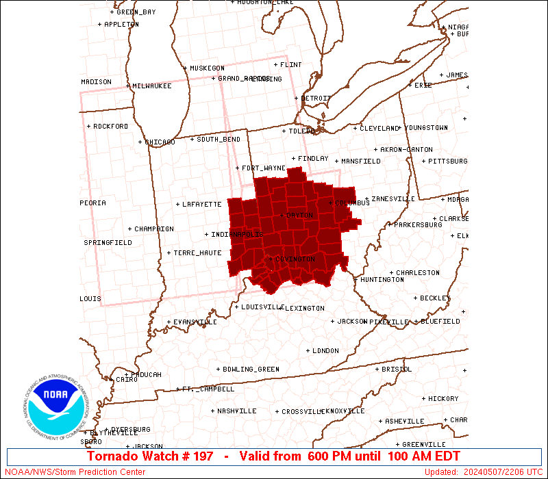
* Tornado Watch for portions of
Eastern Indiana
Northern Kentucky
Western Ohio
* Effective this Tuesday night and Wednesday morning from 600 PM
until 100 AM EDT.
* Primary threats include...
A few tornadoes and a couple intense tornadoes likely
Scattered large hail and isolated very large hail events to 2
inches in diameter likely
Scattered damaging wind gusts to 70 mph likely
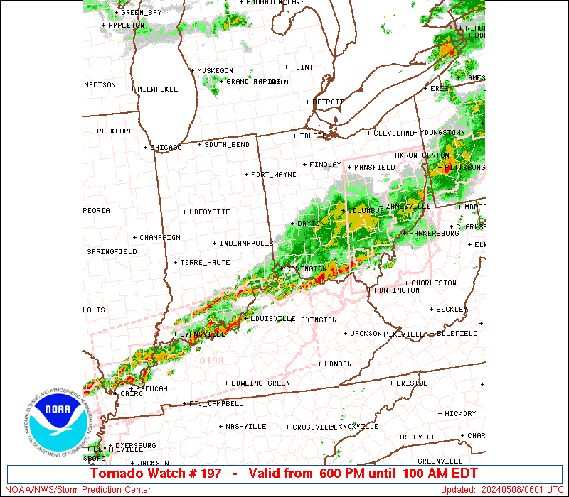
SUMMARY...Scattered intense thunderstorms over central Indiana will
track eastward through the evening, affecting the watch area. Large
hail, damaging winds, and a few tornadoes are possible with this
activity.
The tornado watch area is approximately along and 70 statute miles
east and west of a line from 55 miles north northeast of Dayton OH
to 45 miles south of Cincinnati OH. For a complete depiction of the
watch see the associated watch outline update (WOUS64 KWNS WOU7).
PRECAUTIONARY/PREPAREDNESS ACTIONS...
REMEMBER...A Tornado Watch means conditions are favorable for
tornadoes and severe thunderstorms in and close to the watch
area. Persons in these areas should be on the lookout for
threatening weather conditions and listen for later statements
and possible warnings.
&&
OTHER WATCH INFORMATION...CONTINUE...WW 195...WW 196...
AVIATION...Tornadoes and a few severe thunderstorms with hail
surface and aloft to 2 inches. Extreme turbulence and surface wind
gusts to 60 knots. A few cumulonimbi with maximum tops to 500. Mean
storm motion vector 25035.
...Hart

   SEL7

   URGENT - IMMEDIATE BROADCAST REQUESTED
   Tornado Watch Number 197
   NWS Storm Prediction Center Norman OK
   600 PM EDT Tue May 7 2024

   The NWS Storm Prediction Center has issued a

   * Tornado Watch for portions of
     Eastern Indiana
     Northern Kentucky
     Western Ohio

   * Effective this Tuesday night and Wednesday morning from 600 PM
     until 100 AM EDT.

   * Primary threats include...
     A few tornadoes and a couple intense tornadoes likely
     Scattered large hail and isolated very large hail events to 2
       inches in diameter likely
     Scattered damaging wind gusts to 70 mph likely

   SUMMARY...Scattered intense thunderstorms over central Indiana will
   track eastward through the evening, affecting the watch area.  Large
   hail, damaging winds, and a few tornadoes are possible with this
   activity.

   The tornado watch area is approximately along and 70 statute miles
   east and west of a line from 55 miles north northeast of Dayton OH
   to 45 miles south of Cincinnati OH. For a complete depiction of the
   watch see the associated watch outline update (WOUS64 KWNS WOU7).

   PRECAUTIONARY/PREPAREDNESS ACTIONS...

   REMEMBER...A Tornado Watch means conditions are favorable for
   tornadoes and severe thunderstorms in and close to the watch
   area. Persons in these areas should be on the lookout for
   threatening weather conditions and listen for later statements
   and possible warnings.

   &&

   OTHER WATCH INFORMATION...CONTINUE...WW 195...WW 196...

   AVIATION...Tornadoes and a few severe thunderstorms with hail
   surface and aloft to 2 inches. Extreme turbulence and surface wind
   gusts to 60 knots. A few cumulonimbi with maximum tops to 500. Mean
   storm motion vector 25035.

   ...Hart
 Note:
The Aviation Watch (SAW) product is an approximation to the watch area.
The actual watch is depicted by the shaded areas.
Note:
The Aviation Watch (SAW) product is an approximation to the watch area.
The actual watch is depicted by the shaded areas.
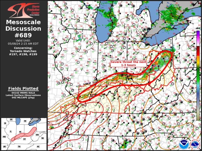
   SAW7
   WW 197 TORNADO IN KY OH 072200Z - 080500Z
   AXIS..70 STATUTE MILES EAST AND WEST OF LINE..
   55NNE DAY/DAYTON OH/ - 45S LUK/CINCINNATI OH/
   ..AVIATION COORDS.. 60NM E/W /23NNE ROD - 37SSE CVG/
   HAIL SURFACE AND ALOFT..2 INCHES. WIND GUSTS..60 KNOTS.
   MAX TOPS TO 500. MEAN STORM MOTION VECTOR 25035.

   LAT...LON 40638248 38438313 38438571 40638515

   THIS IS AN APPROXIMATION TO THE WATCH AREA.  FOR A
   COMPLETE DEPICTION OF THE WATCH SEE WOUS64 KWNS
   FOR WOU7.
Watch 197 Status Report Messages:
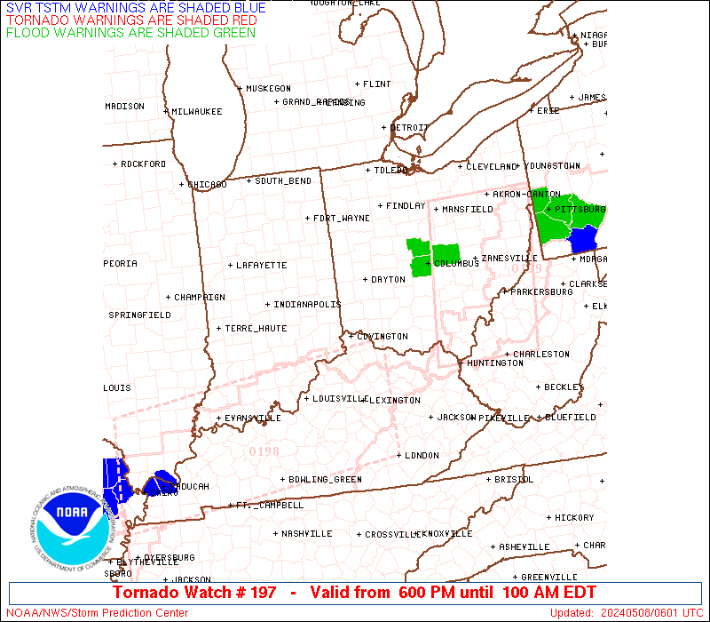
STATUS REPORT #4 ON WW 197

VALID 080425Z - 080540Z

SEVERE WEATHER THREAT CONTINUES RIGHT OF A LINE FROM 50 ESE IND
TO 35 WNW UNI.

..SPC..05/08/24

ATTN...WFO...ILN...IND...

&&

STATUS REPORT FOR WT 197

SEVERE WEATHER THREAT CONTINUES FOR THE FOLLOWING AREAS

INC029-031-079-115-137-155-080540-

IN
.    INDIANA COUNTIES INCLUDED ARE

DEARBORN	     DECATUR		 JENNINGS
OHIO		     RIPLEY		 SWITZERLAND
$$


KYC015-023-037-041-077-081-117-135-161-187-191-201-080540-

KY
.    KENTUCKY COUNTIES INCLUDED ARE

BOONE		     BRACKEN		 CAMPBELL
CARROLL 	     GALLATIN		 GRANT
KENTON		     LEWIS		 MASON
OWEN		     PENDLETON		 ROBERTSON
$$


OHC001-015-025-061-071-073-131-141-145-080540-

OH
.    OHIO COUNTIES INCLUDED ARE

ADAMS		     BROWN		 CLERMONT
HAMILTON	     HIGHLAND		 HOCKING
PIKE		     ROSS		 SCIOTO
$$


THE WATCH STATUS MESSAGE IS FOR GUIDANCE PURPOSES ONLY.  PLEASE
REFER TO WATCH COUNTY NOTIFICATION STATEMENTS FOR OFFICIAL
INFORMATION ON COUNTIES...INDEPENDENT CITIES AND MARINE ZONES
CLEARED FROM SEVERE THUNDERSTORM AND TORNADO WATCHES.
$$

STATUS REPORT #3 ON WW 197

VALID 080325Z - 080440Z

SEVERE WEATHER THREAT CONTINUES RIGHT OF A LINE FROM 35 S MIE TO
15 SSW MFD.

..SPC..05/08/24

ATTN...WFO...ILN...IND...

&&

STATUS REPORT FOR WT 197

SEVERE WEATHER THREAT CONTINUES FOR THE FOLLOWING AREAS

INC029-031-041-047-079-115-137-139-155-161-080440-

IN
.    INDIANA COUNTIES INCLUDED ARE

DEARBORN	     DECATUR		 FAYETTE
FRANKLIN	     JENNINGS		 OHIO
RIPLEY		     RUSH		 SWITZERLAND
UNION
$$


KYC015-023-037-041-077-081-117-135-161-187-191-201-080440-

KY
.    KENTUCKY COUNTIES INCLUDED ARE

BOONE		     BRACKEN		 CAMPBELL
CARROLL 	     GALLATIN		 GRANT
KENTON		     LEWIS		 MASON
OWEN		     PENDLETON		 ROBERTSON
$$


OHC001-015-017-023-025-027-041-045-047-049-057-061-071-073-089-
097-113-129-131-135-141-145-159-165-080440-

OH
.    OHIO COUNTIES INCLUDED ARE

ADAMS		     BROWN		 BUTLER
CLARK		     CLERMONT		 CLINTON
DELAWARE	     FAIRFIELD		 FAYETTE
FRANKLIN	     GREENE		 HAMILTON
HIGHLAND	     HOCKING		 LICKING
MADISON 	     MONTGOMERY 	 PICKAWAY
PIKE		     PREBLE		 ROSS
SCIOTO		     UNION		 WARREN
$$


THE WATCH STATUS MESSAGE IS FOR GUIDANCE PURPOSES ONLY.  PLEASE
REFER TO WATCH COUNTY NOTIFICATION STATEMENTS FOR OFFICIAL
INFORMATION ON COUNTIES...INDEPENDENT CITIES AND MARINE ZONES
CLEARED FROM SEVERE THUNDERSTORM AND TORNADO WATCHES.
$$

STATUS REPORT #2 ON WW 197

VALID 080055Z - 080140Z

SEVERE WEATHER THREAT CONTINUES RIGHT OF A LINE FROM 40 E IND TO
40 SSE MIE TO 30 WNW DAY TO 40 NNW DAY TO 30 ESE FWA.

..BENTLEY..05/08/24

ATTN...WFO...ILN...IND...

&&

STATUS REPORT FOR WT 197

SEVERE WEATHER THREAT CONTINUES FOR THE FOLLOWING AREAS

INC029-031-041-047-079-115-137-139-155-161-177-080140-

IN
.    INDIANA COUNTIES INCLUDED ARE

DEARBORN	     DECATUR		 FAYETTE
FRANKLIN	     JENNINGS		 OHIO
RIPLEY		     RUSH		 SWITZERLAND
UNION		     WAYNE
$$


KYC015-023-037-041-077-081-117-135-161-187-191-201-080140-

KY
.    KENTUCKY COUNTIES INCLUDED ARE

BOONE		     BRACKEN		 CAMPBELL
CARROLL 	     GALLATIN		 GRANT
KENTON		     LEWIS		 MASON
OWEN		     PENDLETON		 ROBERTSON
$$


OHC001-011-015-017-021-023-025-027-037-041-045-047-049-057-061-
065-071-073-089-091-097-107-109-113-129-131-135-141-145-149-159-
165-080140-

OH
.    OHIO COUNTIES INCLUDED ARE

ADAMS		     AUGLAIZE		 BROWN
BUTLER		     CHAMPAIGN		 CLARK
CLERMONT	     CLINTON		 DARKE
DELAWARE	     FAIRFIELD		 FAYETTE
FRANKLIN	     GREENE		 HAMILTON
HARDIN		     HIGHLAND		 HOCKING
LICKING 	     LOGAN		 MADISON
MERCER		     MIAMI		 MONTGOMERY
PICKAWAY	     PIKE		 PREBLE
ROSS		     SCIOTO		 SHELBY
UNION		     WARREN
$$


THE WATCH STATUS MESSAGE IS FOR GUIDANCE PURPOSES ONLY.  PLEASE
REFER TO WATCH COUNTY NOTIFICATION STATEMENTS FOR OFFICIAL
INFORMATION ON COUNTIES...INDEPENDENT CITIES AND MARINE ZONES
CLEARED FROM SEVERE THUNDERSTORM AND TORNADO WATCHES.
$$

STATUS REPORT #1 ON WW 197

VALID 072325Z - 080040Z

THE SEVERE WEATHER THREAT CONTINUES ACROSS THE ENTIRE WATCH AREA.

..BENTLEY..05/07/24

ATTN...WFO...ILN...IND...

&&

STATUS REPORT FOR WT 197

SEVERE WEATHER THREAT CONTINUES FOR THE FOLLOWING AREAS

INC029-031-035-041-047-065-079-115-135-137-139-155-161-177-
080040-

IN
.    INDIANA COUNTIES INCLUDED ARE

DEARBORN	     DECATUR		 DELAWARE
FAYETTE 	     FRANKLIN		 HENRY
JENNINGS	     OHIO		 RANDOLPH
RIPLEY		     RUSH		 SWITZERLAND
UNION		     WAYNE
$$


KYC015-023-037-041-077-081-117-135-161-187-191-201-080040-

KY
.    KENTUCKY COUNTIES INCLUDED ARE

BOONE		     BRACKEN		 CAMPBELL
CARROLL 	     GALLATIN		 GRANT
KENTON		     LEWIS		 MASON
OWEN		     PENDLETON		 ROBERTSON
$$


OHC001-011-015-017-021-023-025-027-037-041-045-047-049-057-061-
065-071-073-089-091-097-107-109-113-129-131-135-141-145-149-159-
165-080040-

OH
.    OHIO COUNTIES INCLUDED ARE

ADAMS		     AUGLAIZE		 BROWN
BUTLER		     CHAMPAIGN		 CLARK
CLERMONT	     CLINTON		 DARKE
DELAWARE	     FAIRFIELD		 FAYETTE
FRANKLIN	     GREENE		 HAMILTON
HARDIN		     HIGHLAND		 HOCKING
LICKING 	     LOGAN		 MADISON
MERCER		     MIAMI		 MONTGOMERY
PICKAWAY	     PIKE		 PREBLE
ROSS		     SCIOTO		 SHELBY
UNION		     WARREN
$$


THE WATCH STATUS MESSAGE IS FOR GUIDANCE PURPOSES ONLY.  PLEASE
REFER TO WATCH COUNTY NOTIFICATION STATEMENTS FOR OFFICIAL
INFORMATION ON COUNTIES...INDEPENDENT CITIES AND MARINE ZONES
CLEARED FROM SEVERE THUNDERSTORM AND TORNADO WATCHES.
$$
Note:
Click for Complete Product Text.
Tornadoes
Probability of 2 or more tornadoes
|
High (70%)
|
Probability of 1 or more strong (EF2-EF5) tornadoes
|
Mod (60%)
|
Wind
Probability of 10 or more severe wind events
|
Mod (60%)
|
Probability of 1 or more wind events > 65 knots
|
Low (20%)
|
Hail
Probability of 10 or more severe hail events
|
High (70%)
|
Probability of 1 or more hailstones > 2 inches
|
Mod (60%)
|
Combined Severe Hail/Wind
Probability of 6 or more combined severe hail/wind events
|
High (>95%)
|
For each watch, probabilities for particular events inside the watch
(listed above in each table) are determined by the issuing forecaster.
The "Low" category contains probability values ranging from less than 2%
to 20% (EF2-EF5 tornadoes), less than 5% to 20% (all other probabilities),
"Moderate" from 30% to 60%, and "High" from 70% to greater than 95%.
High values are bolded and lighter in color to provide awareness of
an increased threat for a particular event.


 @NWSSPC