Note:
The expiration time in the watch graphic is amended if the watch is
replaced, cancelled or extended.
Note:
Note:
The expiration time in the watch graphic is amended if the watch is
replaced, cancelled or extended.
Note: Click for
Watch Status Reports.
SEL7
URGENT - IMMEDIATE BROADCAST REQUESTED
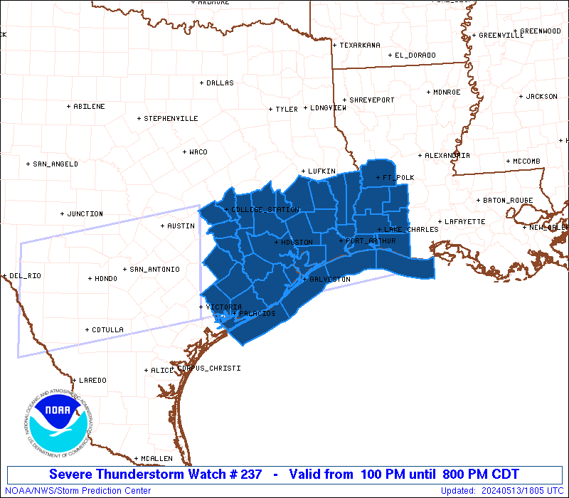
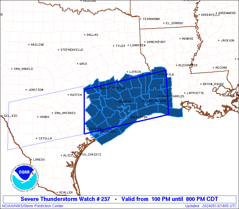
Severe Thunderstorm Watch Number 237
NWS Storm Prediction Center Norman OK
100 PM CDT Mon May 13 2024
The NWS Storm Prediction Center has issued a
* Severe Thunderstorm Watch for portions of
Southwest Louisiana
Southeast Texas
Coastal Waters
* Effective this Monday afternoon and evening from 100 PM until
800 PM CDT.
* Primary threats include...
Scattered damaging winds and isolated significant gusts to 80
mph likely
Scattered large hail and isolated very large hail events to 3
inches in diameter likely
A tornado or two possible
SUMMARY...Clusters of storms are expected to move and develop
eastward into southeast Texas and southwest Louisiana through this
evening. The storm environment favors a mix of supercells capable
of producing very large hail up to 3 inches in diameter, as well as
some upscale growth into clusters/bowing segments with the potential
for damaging winds of 60-80 mph. A tornado or two could occur with
favorable storm/boundary interactions.
The severe thunderstorm watch area is approximately along and 65
statute miles north and south of a line from 50 miles north of
Victoria TX to 25 miles east northeast of Lake Charles LA. For a
complete depiction of the watch see the associated watch outline
update (WOUS64 KWNS WOU7).
PRECAUTIONARY/PREPAREDNESS ACTIONS...
REMEMBER...A Severe Thunderstorm Watch means conditions are
favorable for severe thunderstorms in and close to the watch area.
Persons in these areas should be on the lookout for threatening
weather conditions and listen for later statements and possible
warnings. Severe thunderstorms can and occasionally do produce
tornadoes.
&&
OTHER WATCH INFORMATION...CONTINUE...WW 235...WW 236...
AVIATION...A few severe thunderstorms with hail surface and aloft to
3 inches. Extreme turbulence and surface wind gusts to 70 knots. A
few cumulonimbi with maximum tops to 600. Mean storm motion vector
27030.
...Thompson

   SEL7

   URGENT - IMMEDIATE BROADCAST REQUESTED
   Severe Thunderstorm Watch Number 237
   NWS Storm Prediction Center Norman OK
   100 PM CDT Mon May 13 2024

   The NWS Storm Prediction Center has issued a

   * Severe Thunderstorm Watch for portions of
     Southwest Louisiana
     Southeast Texas
     Coastal Waters

   * Effective this Monday afternoon and evening from 100 PM until
     800 PM CDT.

   * Primary threats include...
     Scattered damaging winds and isolated significant gusts to 80
       mph likely
     Scattered large hail and isolated very large hail events to 3
       inches in diameter likely
     A tornado or two possible

   SUMMARY...Clusters of storms are expected to move and develop
   eastward into southeast Texas and southwest Louisiana through this
   evening.  The storm environment favors a mix of supercells capable
   of producing very large hail up to 3 inches in diameter, as well as
   some upscale growth into clusters/bowing segments with the potential
   for damaging winds of 60-80 mph.  A tornado or two could occur with
   favorable storm/boundary interactions.

   The severe thunderstorm watch area is approximately along and 65
   statute miles north and south of a line from 50 miles north of
   Victoria TX to 25 miles east northeast of Lake Charles LA. For a
   complete depiction of the watch see the associated watch outline
   update (WOUS64 KWNS WOU7).

   PRECAUTIONARY/PREPAREDNESS ACTIONS...

   REMEMBER...A Severe Thunderstorm Watch means conditions are
   favorable for severe thunderstorms in and close to the watch area.
   Persons in these areas should be on the lookout for threatening
   weather conditions and listen for later statements and possible
   warnings. Severe thunderstorms can and occasionally do produce
   tornadoes.

   &&

   OTHER WATCH INFORMATION...CONTINUE...WW 235...WW 236...

   AVIATION...A few severe thunderstorms with hail surface and aloft to
   3 inches. Extreme turbulence and surface wind gusts to 70 knots. A
   few cumulonimbi with maximum tops to 600. Mean storm motion vector
   27030.

   ...Thompson
 Note:
The Aviation Watch (SAW) product is an approximation to the watch area.
The actual watch is depicted by the shaded areas.
Note:
The Aviation Watch (SAW) product is an approximation to the watch area.
The actual watch is depicted by the shaded areas.
   SAW7
   WW 237 SEVERE TSTM LA TX CW 131800Z - 140100Z
   AXIS..65 STATUTE MILES NORTH AND SOUTH OF LINE..
   50N VCT/VICTORIA TX/ - 25ENE LCH/LAKE CHARLES LA/
   ..AVIATION COORDS.. 55NM N/S /58SSE CWK - 16ENE LCH/
   HAIL SURFACE AND ALOFT..3 INCHES. WIND GUSTS..70 KNOTS.
   MAX TOPS TO 600. MEAN STORM MOTION VECTOR 27030.

   LAT...LON 30519692 31219283 29339283 28639692

   THIS IS AN APPROXIMATION TO THE WATCH AREA.  FOR A
   COMPLETE DEPICTION OF THE WATCH SEE WOUS64 KWNS
   FOR WOU7.
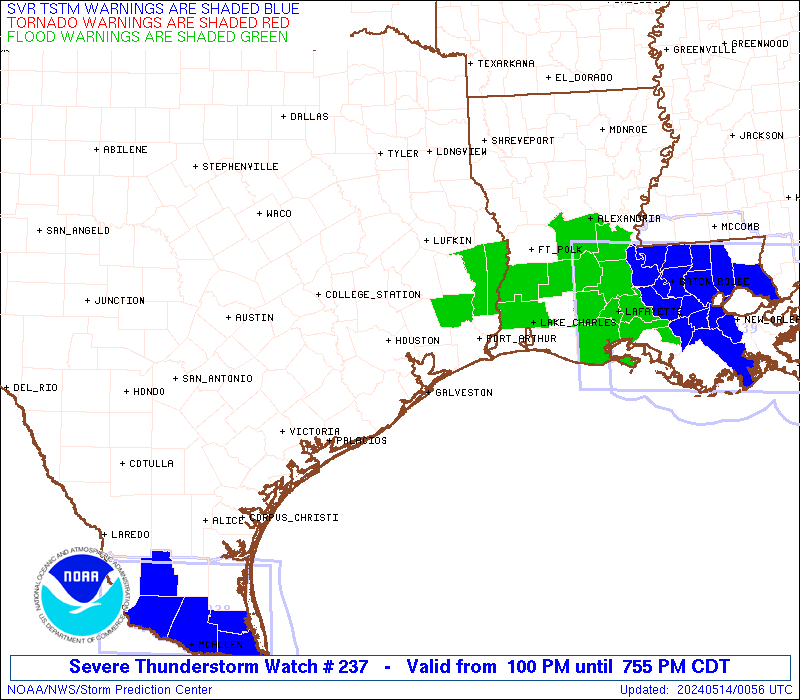
Watch 237 Status Report Messages:
STATUS REPORT #2 ON WW 237
VALID 132035Z - 132140Z
SEVERE WEATHER THREAT CONTINUES RIGHT OF A LINE FROM 20 N VCT TO
45 NNE VCT TO 50 W HOU TO 25 S UTS TO 25 NE UTS.
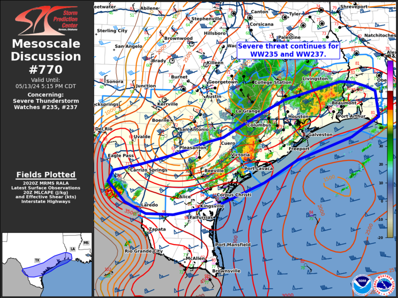
FOR ADDITIONAL INFORMATION SEE MESOSCALE DISCUSSION 770
..GLEASON..05/13/24
ATTN...WFO...LCH...HGX...
&&
STATUS REPORT FOR WS 237
SEVERE WEATHER THREAT CONTINUES FOR THE FOLLOWING AREAS
LAC003-011-019-023-053-115-132140-
LA
. LOUISIANA PARISHES INCLUDED ARE
ALLEN BEAUREGARD CALCASIEU
CAMERON JEFFERSON DAVIS VERNON
$$
TXC039-071-157-167-199-201-239-241-245-291-321-339-351-361-373-
407-457-481-132140-
TX
. TEXAS COUNTIES INCLUDED ARE
BRAZORIA CHAMBERS FORT BEND
GALVESTON HARDIN HARRIS
JACKSON JASPER JEFFERSON
LIBERTY MATAGORDA MONTGOMERY
NEWTON ORANGE POLK
SAN JACINTO TYLER WHARTON
$$
GMZ330-335-350-355-430-432-450-452-132140-
CW
. ADJACENT COASTAL WATERS INCLUDED ARE
MATAGORDA BAY
GALVESTON BAY
COASTAL WATERS FROM FREEPORT TO MATAGORDA SHIP CHANNEL TX OUT 20
NM
COASTAL WATERS FROM HIGH ISLAND TO FREEPORT TX OUT 20 NM
SABINE LAKE
CALCASIEU LAKE
COASTAL WATERS FROM CAMERON LA TO HIGH ISLAND TX OUT 20 NM
COASTAL WATERS FROM INTRACOASTAL CITY TO CAMERON LA OUT 20 NM
$$
THE WATCH STATUS MESSAGE IS FOR GUIDANCE PURPOSES ONLY. PLEASE
REFER TO WATCH COUNTY NOTIFICATION STATEMENTS FOR OFFICIAL
INFORMATION ON COUNTIES...INDEPENDENT CITIES AND MARINE ZONES
CLEARED FROM SEVERE THUNDERSTORM AND TORNADO WATCHES.
$$
STATUS REPORT #1 ON WW 237
VALID 131910Z - 132040Z
THE SEVERE WEATHER THREAT CONTINUES ACROSS THE ENTIRE WATCH AREA.
..GLEASON..05/13/24
ATTN...WFO...LCH...HGX...
&&
STATUS REPORT FOR WS 237
SEVERE WEATHER THREAT CONTINUES FOR THE FOLLOWING AREAS
LAC003-011-019-023-053-115-132040-
LA
. LOUISIANA PARISHES INCLUDED ARE
ALLEN BEAUREGARD CALCASIEU
CAMERON JEFFERSON DAVIS VERNON
$$
TXC015-039-041-051-071-089-157-167-185-199-201-239-241-245-291-
321-339-351-361-373-407-457-471-473-477-481-132040-
TX
. TEXAS COUNTIES INCLUDED ARE
AUSTIN BRAZORIA BRAZOS
BURLESON CHAMBERS COLORADO
FORT BEND GALVESTON GRIMES
HARDIN HARRIS JACKSON
JASPER JEFFERSON LIBERTY
MATAGORDA MONTGOMERY NEWTON
ORANGE POLK SAN JACINTO
TYLER WALKER WALLER
WASHINGTON WHARTON
$$
GMZ330-335-350-355-430-432-450-452-132040-
CW
. ADJACENT COASTAL WATERS INCLUDED ARE
MATAGORDA BAY
GALVESTON BAY
COASTAL WATERS FROM FREEPORT TO MATAGORDA SHIP CHANNEL TX OUT 20
NM
COASTAL WATERS FROM HIGH ISLAND TO FREEPORT TX OUT 20 NM
SABINE LAKE
CALCASIEU LAKE
COASTAL WATERS FROM CAMERON LA TO HIGH ISLAND TX OUT 20 NM
COASTAL WATERS FROM INTRACOASTAL CITY TO CAMERON LA OUT 20 NM
$$
THE WATCH STATUS MESSAGE IS FOR GUIDANCE PURPOSES ONLY. PLEASE
REFER TO WATCH COUNTY NOTIFICATION STATEMENTS FOR OFFICIAL
INFORMATION ON COUNTIES...INDEPENDENT CITIES AND MARINE ZONES
CLEARED FROM SEVERE THUNDERSTORM AND TORNADO WATCHES.
$$
Note:
Click for Complete Product Text.
Tornadoes
Probability of 2 or more tornadoes
|
Low (20%)
|
Probability of 1 or more strong (EF2-EF5) tornadoes
|
Low (5%)
|
Wind
Probability of 10 or more severe wind events
|
Mod (60%)
|
Probability of 1 or more wind events > 65 knots
|
Mod (60%)
|
Hail
Probability of 10 or more severe hail events
|
Mod (60%)
|
Probability of 1 or more hailstones > 2 inches
|
Mod (60%)
|
Combined Severe Hail/Wind
Probability of 6 or more combined severe hail/wind events
|
High (>95%)
|
For each watch, probabilities for particular events inside the watch
(listed above in each table) are determined by the issuing forecaster.
The "Low" category contains probability values ranging from less than 2%
to 20% (EF2-EF5 tornadoes), less than 5% to 20% (all other probabilities),
"Moderate" from 30% to 60%, and "High" from 70% to greater than 95%.
High values are bolded and lighter in color to provide awareness of
an increased threat for a particular event.


 @NWSSPC