 Note:
The expiration time in the watch graphic is amended if the watch is
replaced, cancelled or extended.
Note:
Note:
The expiration time in the watch graphic is amended if the watch is
replaced, cancelled or extended.
Note: Click for
Watch Status Reports.
SEL8
URGENT - IMMEDIATE BROADCAST REQUESTED
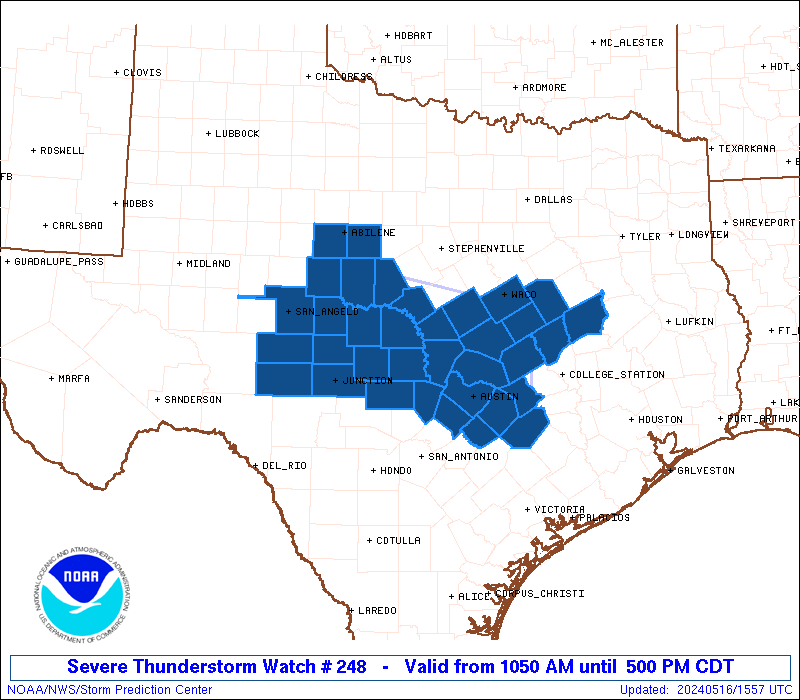
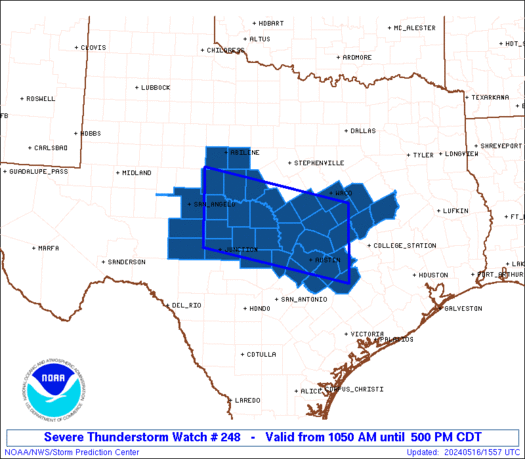
Severe Thunderstorm Watch Number 248
NWS Storm Prediction Center Norman OK
1050 AM CDT Thu May 16 2024
The NWS Storm Prediction Center has issued a
* Severe Thunderstorm Watch for portions of
Central Texas
* Effective this Thursday morning and afternoon from 1050 AM
until 500 PM CDT.
* Primary threats include...
Scattered large hail and isolated very large hail events to 2
inches in diameter likely
Scattered damaging wind gusts to 70 mph likely
A tornado or two possible
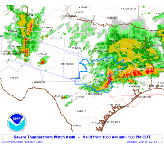
SUMMARY...Clusters of storms, including both supercells and bowing
segments, are expected to continue to increase in coverage and
intensify into the afternoon, mainly along and south of an outflow
boundary that continues to move southward. Damaging winds of 60-70
mph will be the most common threat, though any more
discrete/supercell storms could produce large hail of 1-2 inches in
diameter. An isolated tornado or two could also occur with
favorable storm/boundary interactions.
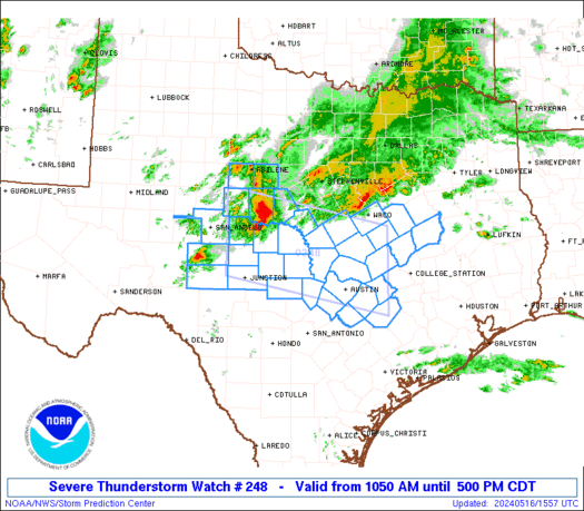
The severe thunderstorm watch area is approximately along and 55
statute miles north and south of a line from 60 miles north
northwest of Junction TX to 50 miles southeast of Temple TX. For a
complete depiction of the watch see the associated watch outline
update (WOUS64 KWNS WOU8).
PRECAUTIONARY/PREPAREDNESS ACTIONS...
REMEMBER...A Severe Thunderstorm Watch means conditions are
favorable for severe thunderstorms in and close to the watch area.
Persons in these areas should be on the lookout for threatening
weather conditions and listen for later statements and possible
warnings. Severe thunderstorms can and occasionally do produce
tornadoes.
&&
AVIATION...A few severe thunderstorms with hail surface and aloft to
2 inches. Extreme turbulence and surface wind gusts to 60 knots. A
few cumulonimbi with maximum tops to 600. Mean storm motion vector
29030.
...Thompson
   SEL8

   URGENT - IMMEDIATE BROADCAST REQUESTED
   Severe Thunderstorm Watch Number 248
   NWS Storm Prediction Center Norman OK
   1050 AM CDT Thu May 16 2024

   The NWS Storm Prediction Center has issued a

   * Severe Thunderstorm Watch for portions of
     Central Texas

   * Effective this Thursday morning and afternoon from 1050 AM
     until 500 PM CDT.

   * Primary threats include...
     Scattered large hail and isolated very large hail events to 2
       inches in diameter likely
     Scattered damaging wind gusts to 70 mph likely
     A tornado or two possible

   SUMMARY...Clusters of storms, including both supercells and bowing
   segments, are expected to continue to increase in coverage and
   intensify into the afternoon, mainly along and south of an outflow
   boundary that continues to move southward.  Damaging winds of 60-70
   mph will be the most common threat, though any more
   discrete/supercell storms could produce large hail of 1-2 inches in
   diameter.  An isolated tornado or two could also occur with
   favorable storm/boundary interactions.

   The severe thunderstorm watch area is approximately along and 55
   statute miles north and south of a line from 60 miles north
   northwest of Junction TX to 50 miles southeast of Temple TX. For a
   complete depiction of the watch see the associated watch outline
   update (WOUS64 KWNS WOU8).

   PRECAUTIONARY/PREPAREDNESS ACTIONS...

   REMEMBER...A Severe Thunderstorm Watch means conditions are
   favorable for severe thunderstorms in and close to the watch area.
   Persons in these areas should be on the lookout for threatening
   weather conditions and listen for later statements and possible
   warnings. Severe thunderstorms can and occasionally do produce
   tornadoes.

   &&

   AVIATION...A few severe thunderstorms with hail surface and aloft to
   2 inches. Extreme turbulence and surface wind gusts to 60 knots. A
   few cumulonimbi with maximum tops to 600. Mean storm motion vector
   29030.

   ...Thompson
 Note:
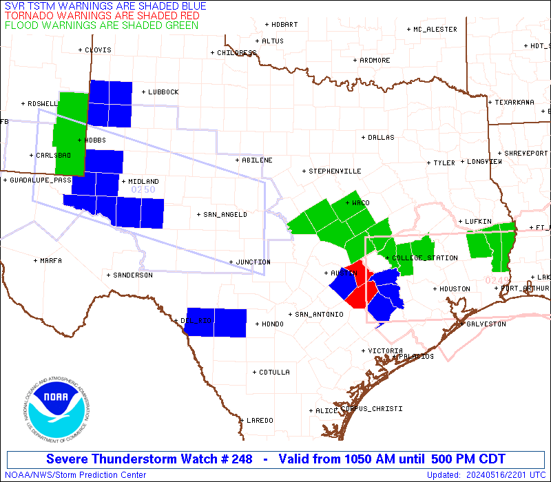
The Aviation Watch (SAW) product is an approximation to the watch area.
The actual watch is depicted by the shaded areas.
Note:
The Aviation Watch (SAW) product is an approximation to the watch area.
The actual watch is depicted by the shaded areas.
   SAW8
   WW 248 SEVERE TSTM TX 161550Z - 162200Z
   AXIS..55 STATUTE MILES NORTH AND SOUTH OF LINE..
   60NNW JCT/JUNCTION TX/ - 50SE TPL/TEMPLE TX/
   ..AVIATION COORDS.. 50NM N/S /16ESE SJT - 40ENE CWK/
   HAIL SURFACE AND ALOFT..2 INCHES. WIND GUSTS..60 KNOTS.
   MAX TOPS TO 600. MEAN STORM MOTION VECTOR 29030.

   LAT...LON 32120016 31439683 29849683 30530016

   THIS IS AN APPROXIMATION TO THE WATCH AREA.  FOR A
   COMPLETE DEPICTION OF THE WATCH SEE WOUS64 KWNS
   FOR WOU8.
Watch 248 Status Report Message has not been issued yet.
Note:
Click for Complete Product Text.
Tornadoes
Probability of 2 or more tornadoes
|
Low (20%)
|
Probability of 1 or more strong (EF2-EF5) tornadoes
|
Low (5%)
|
Wind
Probability of 10 or more severe wind events
|
Mod (60%)
|
Probability of 1 or more wind events > 65 knots
|
Low (20%)
|
Hail
Probability of 10 or more severe hail events
|
Mod (60%)
|
Probability of 1 or more hailstones > 2 inches
|
Mod (60%)
|
Combined Severe Hail/Wind
Probability of 6 or more combined severe hail/wind events
|
High (90%)
|
For each watch, probabilities for particular events inside the watch
(listed above in each table) are determined by the issuing forecaster.
The "Low" category contains probability values ranging from less than 2%
to 20% (EF2-EF5 tornadoes), less than 5% to 20% (all other probabilities),
"Moderate" from 30% to 60%, and "High" from 70% to greater than 95%.
High values are bolded and lighter in color to provide awareness of
an increased threat for a particular event.


 @NWSSPC