 Note:
The expiration time in the watch graphic is amended if the watch is
replaced, cancelled or extended.
Note:
Note:
The expiration time in the watch graphic is amended if the watch is
replaced, cancelled or extended.
Note: Click for
Watch Status Reports.
SEL7
URGENT - IMMEDIATE BROADCAST REQUESTED
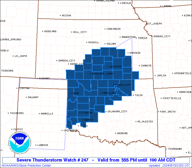
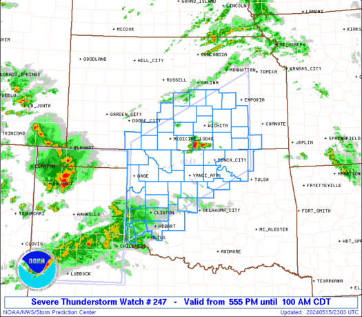
Severe Thunderstorm Watch Number 247
NWS Storm Prediction Center Norman OK
555 PM CDT Wed May 15 2024
The NWS Storm Prediction Center has issued a
* Severe Thunderstorm Watch for portions of
South-Central Kansas
Western and Northern Oklahoma
* Effective this Wednesday afternoon and Thursday morning from
555 PM until 100 AM CDT.
* Primary threats include...
Scattered damaging winds and isolated significant gusts to 80
mph likely
Scattered large hail and isolated very large hail events to 2.5
inches in diameter likely
A tornado or two possible
SUMMARY...Several clusters of strong to severe thunderstorms are
forecast to develop this evening across western into northern
Oklahoma and into south-central Kansas. The environment will
support a mix of supercells and organized linear clusters. A threat
for large to very large hail will seemingly be greatest through the
mid evening with any supercells. A non-zero risk for a tornado this
evening may focus over far northern Oklahoma and southern Kansas.
By mid to late evening, the risk for severe gusts will likely become
the primary severe hazard.
The severe thunderstorm watch area is approximately along and 90
statute miles north and south of a line from 55 miles northwest of
Clinton OK to 40 miles south southeast of Emporia KS. For a complete
depiction of the watch see the associated watch outline update
(WOUS64 KWNS WOU7).
PRECAUTIONARY/PREPAREDNESS ACTIONS...
REMEMBER...A Severe Thunderstorm Watch means conditions are
favorable for severe thunderstorms in and close to the watch area.
Persons in these areas should be on the lookout for threatening
weather conditions and listen for later statements and possible
warnings. Severe thunderstorms can and occasionally do produce
tornadoes.
&&
OTHER WATCH INFORMATION...CONTINUE...WW 245...WW 246...
AVIATION...A few severe thunderstorms with hail surface and aloft to
2.5 inches. Extreme turbulence and surface wind gusts to 70 knots. A
few cumulonimbi with maximum tops to 500. Mean storm motion vector
24035.
...Smith
   SEL7

   URGENT - IMMEDIATE BROADCAST REQUESTED
   Severe Thunderstorm Watch Number 247
   NWS Storm Prediction Center Norman OK
   555 PM CDT Wed May 15 2024

   The NWS Storm Prediction Center has issued a

   * Severe Thunderstorm Watch for portions of
     South-Central Kansas
     Western and Northern Oklahoma

   * Effective this Wednesday afternoon and Thursday morning from
     555 PM until 100 AM CDT.

   * Primary threats include...
     Scattered damaging winds and isolated significant gusts to 80
       mph likely
     Scattered large hail and isolated very large hail events to 2.5
       inches in diameter likely
     A tornado or two possible

   SUMMARY...Several clusters of strong to severe thunderstorms are
   forecast to develop this evening across western into northern
   Oklahoma and into south-central Kansas.  The environment will
   support a mix of supercells and organized linear clusters.  A threat
   for large to very large hail will seemingly be greatest through the
   mid evening with any supercells.  A non-zero risk for a tornado this
   evening may focus over far northern Oklahoma and southern Kansas.
   By mid to late evening, the risk for severe gusts will likely become
   the primary severe hazard.

   The severe thunderstorm watch area is approximately along and 90
   statute miles north and south of a line from 55 miles northwest of
   Clinton OK to 40 miles south southeast of Emporia KS. For a complete
   depiction of the watch see the associated watch outline update
   (WOUS64 KWNS WOU7).

   PRECAUTIONARY/PREPAREDNESS ACTIONS...

   REMEMBER...A Severe Thunderstorm Watch means conditions are
   favorable for severe thunderstorms in and close to the watch area.
   Persons in these areas should be on the lookout for threatening
   weather conditions and listen for later statements and possible
   warnings. Severe thunderstorms can and occasionally do produce
   tornadoes.

   &&

   OTHER WATCH INFORMATION...CONTINUE...WW 245...WW 246...

   AVIATION...A few severe thunderstorms with hail surface and aloft to
   2.5 inches. Extreme turbulence and surface wind gusts to 70 knots. A
   few cumulonimbi with maximum tops to 500. Mean storm motion vector
   24035.

   ...Smith
 Note:
The Aviation Watch (SAW) product is an approximation to the watch area.
The actual watch is depicted by the shaded areas.
Note:
The Aviation Watch (SAW) product is an approximation to the watch area.
The actual watch is depicted by the shaded areas.
SAW7
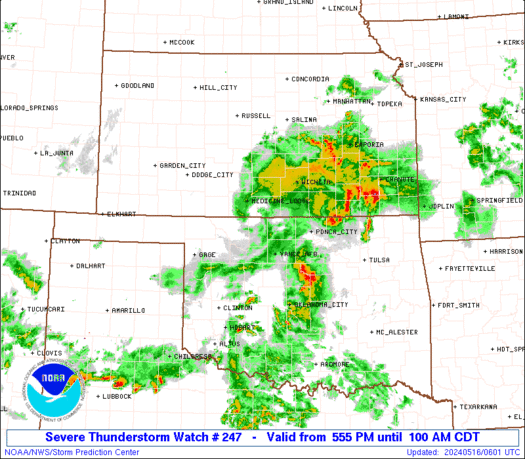
WW 247 SEVERE TSTM KS OK 152255Z - 160600Z
AXIS..90 STATUTE MILES NORTH AND SOUTH OF LINE..
55NW CSM/CLINTON OK/ - 40SSE EMP/EMPORIA KS/
..AVIATION COORDS.. 80NM N/S /27S MMB - 51NW OSW/
HAIL SURFACE AND ALOFT..2.5 INCHES. WIND GUSTS..70 KNOTS.
MAX TOPS TO 500. MEAN STORM MOTION VECTOR 24035.
LAT...LON 37189989 39099590 36499590 34599989
THIS IS AN APPROXIMATION TO THE WATCH AREA. FOR A
COMPLETE DEPICTION OF THE WATCH SEE WOUS64 KWNS
FOR WOU7.
Watch 247 Status Report Messages:
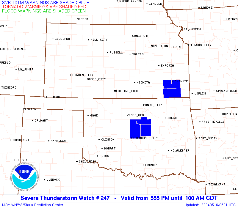
STATUS REPORT #3 ON WW 247
VALID 160535Z - 160600Z
SEVERE WEATHER THREAT CONTINUES RIGHT OF A LINE FROM 25 NNW FSI
TO 20 ESE ICT TO 25 NNW HUT.
WW 247 WILL BE ALLOWED TO EXPIRE AT 160600Z.
..DEAN..05/16/24
ATTN...WFO...DDC...ICT...OUN...TSA...
&&
STATUS REPORT FOR WS 247
SEVERE WEATHER THREAT CONTINUES FOR THE FOLLOWING AREAS
KSC015-019-035-049-073-079-125-173-160600-
KS
. KANSAS COUNTIES INCLUDED ARE
BUTLER CHAUTAUQUA COWLEY
ELK GREENWOOD HARVEY
MONTGOMERY SEDGWICK
$$
OKC047-071-103-105-113-117-131-143-147-160600-
OK
. OKLAHOMA COUNTIES INCLUDED ARE
GARFIELD KAY NOBLE
NOWATA OSAGE PAWNEE
ROGERS TULSA WASHINGTON
$$
THE WATCH STATUS MESSAGE IS FOR GUIDANCE PURPOSES ONLY. PLEASE
REFER TO WATCH COUNTY NOTIFICATION STATEMENTS FOR OFFICIAL
INFORMATION ON COUNTIES...INDEPENDENT CITIES AND MARINE ZONES
CLEARED FROM SEVERE THUNDERSTORM AND TORNADO WATCHES.
$$
STATUS REPORT #2 ON WW 247
VALID 160240Z - 160340Z
SEVERE WEATHER THREAT CONTINUES RIGHT OF A LINE FROM 35 NNE CDS
TO 20 W END TO 25 ESE AVK TO 50 E LBL.
..SQUITIERI..05/16/24
ATTN...WFO...DDC...ICT...OUN...TSA...
&&
STATUS REPORT FOR WS 247
SEVERE WEATHER THREAT CONTINUES FOR THE FOLLOWING AREAS
KSC007-015-019-025-033-035-049-073-077-079-095-097-125-151-155-
173-185-191-160340-
KS
. KANSAS COUNTIES INCLUDED ARE
BARBER BUTLER CHAUTAUQUA
CLARK COMANCHE COWLEY
ELK GREENWOOD HARPER
HARVEY KINGMAN KIOWA
MONTGOMERY PRATT RENO
SEDGWICK STAFFORD SUMNER
$$
OKC003-011-015-017-047-053-055-057-071-073-075-083-103-105-113-
117-119-131-143-147-149-160340-
OK
. OKLAHOMA COUNTIES INCLUDED ARE
ALFALFA BLAINE CADDO
CANADIAN GARFIELD GRANT
GREER HARMON KAY
KINGFISHER KIOWA LOGAN
NOBLE NOWATA OSAGE
PAWNEE PAYNE ROGERS
TULSA WASHINGTON WASHITA
$$
THE WATCH STATUS MESSAGE IS FOR GUIDANCE PURPOSES ONLY. PLEASE
REFER TO WATCH COUNTY NOTIFICATION STATEMENTS FOR OFFICIAL
INFORMATION ON COUNTIES...INDEPENDENT CITIES AND MARINE ZONES
CLEARED FROM SEVERE THUNDERSTORM AND TORNADO WATCHES.
$$
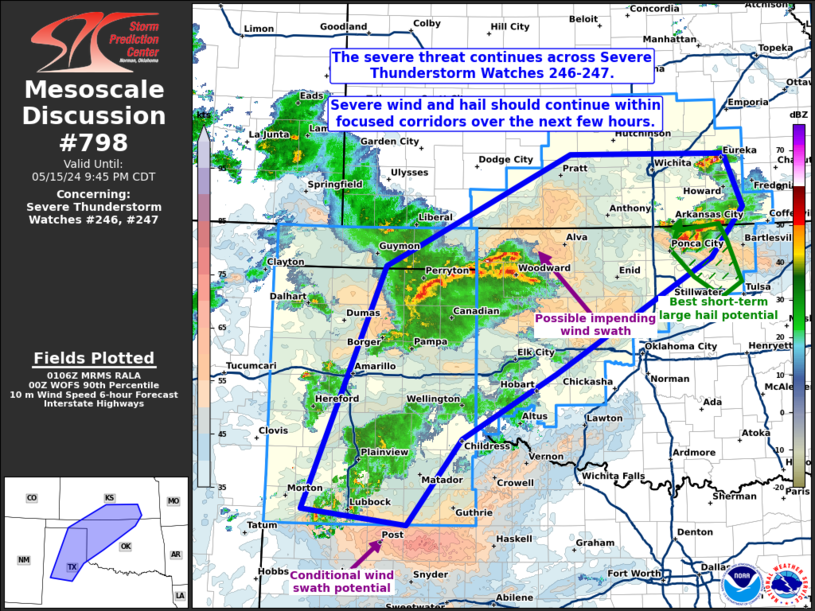
STATUS REPORT #1 ON WW 247
VALID 160125Z - 160240Z
THE SEVERE WEATHER THREAT CONTINUES ACROSS THE ENTIRE WATCH AREA.
FOR ADDITIONAL INFORMATION SEE MESOSCALE DISCUSSION 798
..SQUITIERI..05/16/24
ATTN...WFO...DDC...ICT...OUN...TSA...
&&
STATUS REPORT FOR WS 247
SEVERE WEATHER THREAT CONTINUES FOR THE FOLLOWING AREAS
KSC007-015-017-019-025-033-035-049-073-077-079-095-097-113-115-
125-151-155-159-173-185-191-160240-
KS
. KANSAS COUNTIES INCLUDED ARE
BARBER BUTLER CHASE
CHAUTAUQUA CLARK COMANCHE
COWLEY ELK GREENWOOD
HARPER HARVEY KINGMAN
KIOWA MCPHERSON MARION
MONTGOMERY PRATT RENO
RICE SEDGWICK STAFFORD
SUMNER
$$
OKC003-009-011-015-017-039-043-045-047-053-055-057-059-071-073-
075-083-093-103-113-117-119-129-147-149-151-153-160240-
OK
. OKLAHOMA COUNTIES INCLUDED ARE
ALFALFA BECKHAM BLAINE
CADDO CANADIAN CUSTER
DEWEY ELLIS GARFIELD
GRANT GREER HARMON
HARPER KAY KINGFISHER
KIOWA LOGAN MAJOR
NOBLE OSAGE PAWNEE
PAYNE ROGER MILLS WASHINGTON
WASHITA WOODS WOODWARD
$$
THE WATCH STATUS MESSAGE IS FOR GUIDANCE PURPOSES ONLY. PLEASE
REFER TO WATCH COUNTY NOTIFICATION STATEMENTS FOR OFFICIAL
INFORMATION ON COUNTIES...INDEPENDENT CITIES AND MARINE ZONES
CLEARED FROM SEVERE THUNDERSTORM AND TORNADO WATCHES.
$$
Note:
Click for Complete Product Text.
Tornadoes
Probability of 2 or more tornadoes
|
Low (20%)
|
Probability of 1 or more strong (EF2-EF5) tornadoes
|
Low (<2%)
|
Wind
Probability of 10 or more severe wind events
|
Mod (60%)
|
Probability of 1 or more wind events > 65 knots
|
Mod (60%)
|
Hail
Probability of 10 or more severe hail events
|
Mod (60%)
|
Probability of 1 or more hailstones > 2 inches
|
Mod (60%)
|
Combined Severe Hail/Wind
Probability of 6 or more combined severe hail/wind events
|
High (>95%)
|
For each watch, probabilities for particular events inside the watch
(listed above in each table) are determined by the issuing forecaster.
The "Low" category contains probability values ranging from less than 2%
to 20% (EF2-EF5 tornadoes), less than 5% to 20% (all other probabilities),
"Moderate" from 30% to 60%, and "High" from 70% to greater than 95%.
High values are bolded and lighter in color to provide awareness of
an increased threat for a particular event.


 @NWSSPC