 Note:
The expiration time in the watch graphic is amended if the watch is
replaced, cancelled or extended.
Note:
Note:
The expiration time in the watch graphic is amended if the watch is
replaced, cancelled or extended.
Note: Click for
Watch Status Reports.
SEL2
URGENT - IMMEDIATE BROADCAST REQUESTED
Severe Thunderstorm Watch Number 292
NWS Storm Prediction Center Norman OK
1250 PM EDT Thu May 23 2024
The NWS Storm Prediction Center has issued a
* Severe Thunderstorm Watch for portions of
Maine
* Effective this Thursday afternoon and evening from 1250 PM
until 700 PM EDT.
* Primary threats include...
Scattered damaging wind gusts to 65 mph possible
Scattered large hail events to 1.5 inches in diameter possible
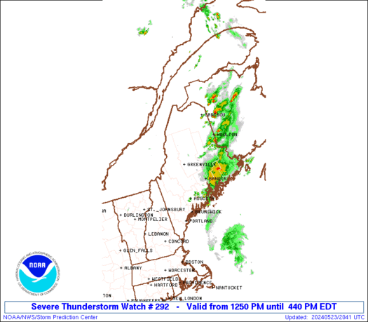
SUMMARY...Thunderstorms are intensifying across western Maine, and
should spread across the region through the afternoon. Locally
damaging wind gusts and hail are possible in the stronger storms.
The severe thunderstorm watch area is approximately along and 60
statute miles east and west of a line from 40 miles west northwest
of Caribou ME to 25 miles east of Augusta ME. For a complete
depiction of the watch see the associated watch outline update
(WOUS64 KWNS WOU2).
PRECAUTIONARY/PREPAREDNESS ACTIONS...
REMEMBER...A Severe Thunderstorm Watch means conditions are
favorable for severe thunderstorms in and close to the watch area.
Persons in these areas should be on the lookout for threatening
weather conditions and listen for later statements and possible
warnings. Severe thunderstorms can and occasionally do produce
tornadoes.
&&
AVIATION...A few severe thunderstorms with hail surface and aloft to
1.5 inches. Extreme turbulence and surface wind gusts to 55 knots. A
few cumulonimbi with maximum tops to 450. Mean storm motion vector
27030.
...Hart

   SEL2

   URGENT - IMMEDIATE BROADCAST REQUESTED
   Severe Thunderstorm Watch Number 292
   NWS Storm Prediction Center Norman OK
   1250 PM EDT Thu May 23 2024

   The NWS Storm Prediction Center has issued a

   * Severe Thunderstorm Watch for portions of
     Maine

   * Effective this Thursday afternoon and evening from 1250 PM
     until 700 PM EDT.

   * Primary threats include...
     Scattered damaging wind gusts to 65 mph possible
     Scattered large hail events to 1.5 inches in diameter possible

   SUMMARY...Thunderstorms are intensifying across western Maine, and
   should spread across the region through the afternoon.  Locally
   damaging wind gusts and hail are possible in the stronger storms.

   The severe thunderstorm watch area is approximately along and 60
   statute miles east and west of a line from 40 miles west northwest
   of Caribou ME to 25 miles east of Augusta ME. For a complete
   depiction of the watch see the associated watch outline update
   (WOUS64 KWNS WOU2).

   PRECAUTIONARY/PREPAREDNESS ACTIONS...

   REMEMBER...A Severe Thunderstorm Watch means conditions are
   favorable for severe thunderstorms in and close to the watch area.
   Persons in these areas should be on the lookout for threatening
   weather conditions and listen for later statements and possible
   warnings. Severe thunderstorms can and occasionally do produce
   tornadoes.

   &&

   AVIATION...A few severe thunderstorms with hail surface and aloft to
   1.5 inches. Extreme turbulence and surface wind gusts to 55 knots. A
   few cumulonimbi with maximum tops to 450. Mean storm motion vector
   27030.

   ...Hart
 Note:
The Aviation Watch (SAW) product is an approximation to the watch area.
The actual watch is depicted by the shaded areas.
Note:
The Aviation Watch (SAW) product is an approximation to the watch area.
The actual watch is depicted by the shaded areas.
   SAW2
   WW 292 SEVERE TSTM ME 231650Z - 232300Z
   AXIS..60 STATUTE MILES EAST AND WEST OF LINE..
   40WNW CAR/CARIBOU ME/ - 25E AUG/AUGUSTA ME/
   ..AVIATION COORDS.. 50NM E/W /35WNW PQI - 36SSW BGR/
   HAIL SURFACE AND ALOFT..1.5 INCHES. WIND GUSTS..55 KNOTS.
   MAX TOPS TO 450. MEAN STORM MOTION VECTOR 27030.

   LAT...LON 47086753 44316808 44317051 47087008

   THIS IS AN APPROXIMATION TO THE WATCH AREA.  FOR A
   COMPLETE DEPICTION OF THE WATCH SEE WOUS64 KWNS
   FOR WOU2.
Watch 292 Status Report Messages:
STATUS REPORT #3 ON WW 292

VALID 232030Z - 232140Z

SEVERE WEATHER THREAT CONTINUES RIGHT OF A LINE FROM 45 SSW BHB
TO 25 W HUL TO 25 NNE CAR.

FOR ADDITIONAL INFORMATION SEE MESOSCALE DISCUSSION 913

..DEAN..05/23/24

ATTN...WFO...GYX...CAR...

&&

STATUS REPORT FOR WS 292

SEVERE WEATHER THREAT CONTINUES FOR THE FOLLOWING AREAS

MEC003-009-019-029-232140-

ME
.    MAINE COUNTIES INCLUDED ARE

AROOSTOOK	     HANCOCK		 PENOBSCOT
WASHINGTON
$$


THE WATCH STATUS MESSAGE IS FOR GUIDANCE PURPOSES ONLY.  PLEASE
REFER TO WATCH COUNTY NOTIFICATION STATEMENTS FOR OFFICIAL
INFORMATION ON COUNTIES...INDEPENDENT CITIES AND MARINE ZONES
CLEARED FROM SEVERE THUNDERSTORM AND TORNADO WATCHES.
$$

STATUS REPORT #2 ON WW 292

VALID 231940Z - 232040Z

SEVERE WEATHER THREAT CONTINUES RIGHT OF A LINE FROM 15 NE LCI TO
5 N AUG TO 45 N CAR.

FOR ADDITIONAL INFORMATION SEE MESOSCALE DISCUSSION 913

..DEAN..05/23/24

ATTN...WFO...GYX...CAR...

&&

STATUS REPORT FOR WS 292

SEVERE WEATHER THREAT CONTINUES FOR THE FOLLOWING AREAS

MEC003-009-013-015-019-023-027-029-232040-

ME
.    MAINE COUNTIES INCLUDED ARE

AROOSTOOK	     HANCOCK		 KNOX
LINCOLN 	     PENOBSCOT		 SAGADAHOC
WALDO		     WASHINGTON
$$


THE WATCH STATUS MESSAGE IS FOR GUIDANCE PURPOSES ONLY.  PLEASE
REFER TO WATCH COUNTY NOTIFICATION STATEMENTS FOR OFFICIAL
INFORMATION ON COUNTIES...INDEPENDENT CITIES AND MARINE ZONES
CLEARED FROM SEVERE THUNDERSTORM AND TORNADO WATCHES.
$$

STATUS REPORT #1 ON WW 292

VALID 231730Z - 231840Z

THE SEVERE WEATHER THREAT CONTINUES ACROSS THE ENTIRE WATCH AREA.

..DEAN..05/23/24

ATTN...WFO...GYX...CAR...

&&

STATUS REPORT FOR WS 292

SEVERE WEATHER THREAT CONTINUES FOR THE FOLLOWING AREAS

MEC001-003-007-009-011-013-015-017-019-021-023-025-027-029-
231840-

ME
.    MAINE COUNTIES INCLUDED ARE

ANDROSCOGGIN	     AROOSTOOK		 FRANKLIN
HANCOCK 	     KENNEBEC		 KNOX
LINCOLN 	     OXFORD		 PENOBSCOT
PISCATAQUIS	     SAGADAHOC		 SOMERSET
WALDO		     WASHINGTON
$$


THE WATCH STATUS MESSAGE IS FOR GUIDANCE PURPOSES ONLY.  PLEASE
REFER TO WATCH COUNTY NOTIFICATION STATEMENTS FOR OFFICIAL
INFORMATION ON COUNTIES...INDEPENDENT CITIES AND MARINE ZONES
CLEARED FROM SEVERE THUNDERSTORM AND TORNADO WATCHES.
$$
Note:
Click for Complete Product Text.
Tornadoes
Probability of 2 or more tornadoes
|
Low (<5%)
|
Probability of 1 or more strong (EF2-EF5) tornadoes
|
Low (<2%)
|
Wind
Probability of 10 or more severe wind events
|
Mod (40%)
|
Probability of 1 or more wind events > 65 knots
|
Low (20%)
|
Hail
Probability of 10 or more severe hail events
|
Mod (40%)
|
Probability of 1 or more hailstones > 2 inches
|
Low (20%)
|
Combined Severe Hail/Wind
Probability of 6 or more combined severe hail/wind events
|
High (70%)
|
For each watch, probabilities for particular events inside the watch
(listed above in each table) are determined by the issuing forecaster.
The "Low" category contains probability values ranging from less than 2%
to 20% (EF2-EF5 tornadoes), less than 5% to 20% (all other probabilities),
"Moderate" from 30% to 60%, and "High" from 70% to greater than 95%.
High values are bolded and lighter in color to provide awareness of
an increased threat for a particular event.


 @NWSSPC


