Note:
The expiration time in the watch graphic is amended if the watch is
replaced, cancelled or extended.
Note:
Note:
The expiration time in the watch graphic is amended if the watch is
replaced, cancelled or extended.
Note: Click for
Watch Status Reports.
SEL0
URGENT - IMMEDIATE BROADCAST REQUESTED
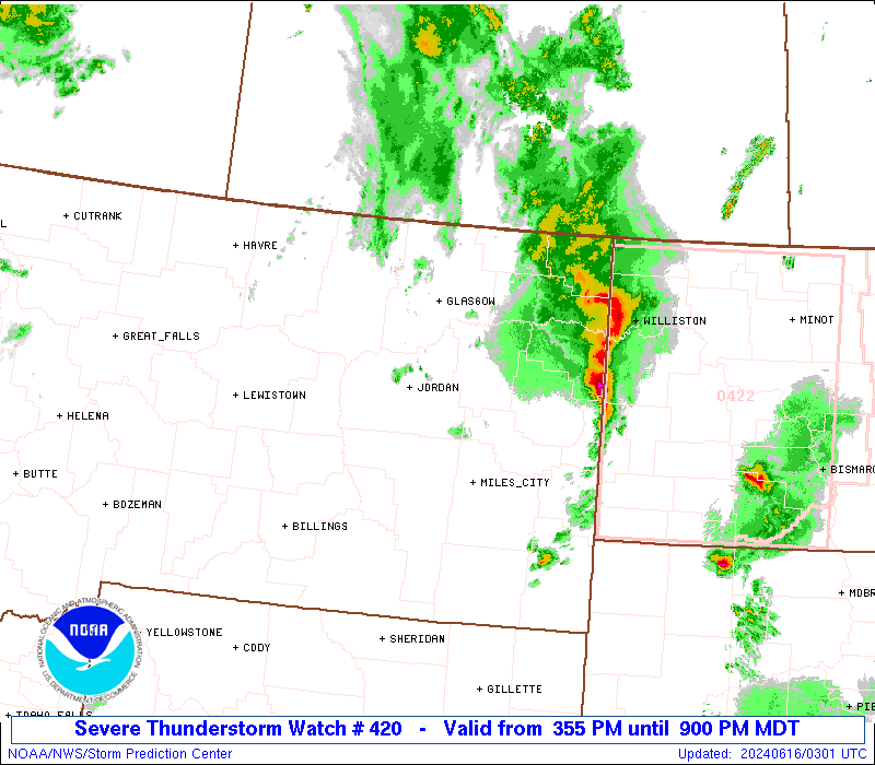
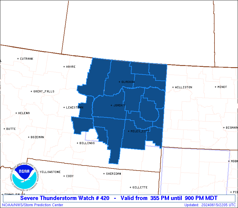
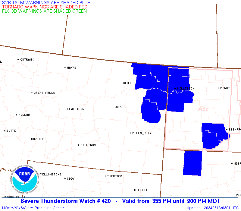
Severe Thunderstorm Watch Number 420
NWS Storm Prediction Center Norman OK
355 PM MDT Sat Jun 15 2024
The NWS Storm Prediction Center has issued a
* Severe Thunderstorm Watch for portions of
Central and Eastern Montana
* Effective this Saturday afternoon and evening from 355 PM until
900 PM MDT.
* Primary threats include...
Scattered damaging winds and isolated significant gusts to 85
mph likely
Isolated very large hail events to 2 inches in diameter possible
A tornado or two possible
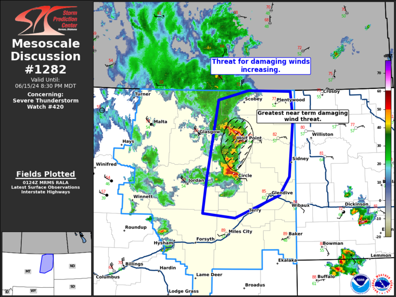
SUMMARY...An intensifying broken band of thunderstorms is forecast
to grow upscale into a squall line this afternoon and into the
evening across the Watch area. Severe gusts (60-85 mph) will be the
primary hazard with the band of storms. Large hail may accompany
any more discrete storm on the south flank of the evolving
thunderstorm activity during the evening, as well as perhaps a brief
risk for a tornado.
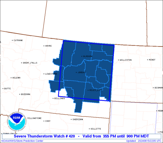
The severe thunderstorm watch area is approximately along and 95
statute miles east and west of a line from 55 miles north northeast
of Glasgow MT to 35 miles south southwest of Miles City MT. For a
complete depiction of the watch see the associated watch outline
update (WOUS64 KWNS WOU0).
PRECAUTIONARY/PREPAREDNESS ACTIONS...
REMEMBER...A Severe Thunderstorm Watch means conditions are
favorable for severe thunderstorms in and close to the watch area.
Persons in these areas should be on the lookout for threatening
weather conditions and listen for later statements and possible
warnings. Severe thunderstorms can and occasionally do produce
tornadoes.
&&
OTHER WATCH INFORMATION...CONTINUE...WW 417...WW 418...WW 419...
AVIATION...A few severe thunderstorms with hail surface and aloft to
2 inches. Extreme turbulence and surface wind gusts to 75 knots. A
few cumulonimbi with maximum tops to 450. Mean storm motion vector
26040.
...Smith

   SEL0

   URGENT - IMMEDIATE BROADCAST REQUESTED
   Severe Thunderstorm Watch Number 420
   NWS Storm Prediction Center Norman OK
   355 PM MDT Sat Jun 15 2024

   The NWS Storm Prediction Center has issued a

   * Severe Thunderstorm Watch for portions of
     Central and Eastern Montana

   * Effective this Saturday afternoon and evening from 355 PM until
     900 PM MDT.

   * Primary threats include...
     Scattered damaging winds and isolated significant gusts to 85
       mph likely
     Isolated very large hail events to 2 inches in diameter possible
     A tornado or two possible

   SUMMARY...An intensifying broken band of thunderstorms is forecast
   to grow upscale into a squall line this afternoon and into the
   evening across the Watch area.  Severe gusts (60-85 mph) will be the
   primary hazard with the band of storms.  Large hail may accompany
   any more discrete storm on the south flank of the evolving
   thunderstorm activity during the evening, as well as perhaps a brief
   risk for a tornado.

   The severe thunderstorm watch area is approximately along and 95
   statute miles east and west of a line from 55 miles north northeast
   of Glasgow MT to 35 miles south southwest of Miles City MT. For a
   complete depiction of the watch see the associated watch outline
   update (WOUS64 KWNS WOU0).

   PRECAUTIONARY/PREPAREDNESS ACTIONS...

   REMEMBER...A Severe Thunderstorm Watch means conditions are
   favorable for severe thunderstorms in and close to the watch area.
   Persons in these areas should be on the lookout for threatening
   weather conditions and listen for later statements and possible
   warnings. Severe thunderstorms can and occasionally do produce
   tornadoes.

   &&

   OTHER WATCH INFORMATION...CONTINUE...WW 417...WW 418...WW 419...

   AVIATION...A few severe thunderstorms with hail surface and aloft to
   2 inches. Extreme turbulence and surface wind gusts to 75 knots. A
   few cumulonimbi with maximum tops to 450. Mean storm motion vector
   26040.

   ...Smith
 Note:
The Aviation Watch (SAW) product is an approximation to the watch area.
The actual watch is depicted by the shaded areas.
Note:
The Aviation Watch (SAW) product is an approximation to the watch area.
The actual watch is depicted by the shaded areas.
   SAW0
   WW 420 SEVERE TSTM MT 152155Z - 160300Z
   AXIS..95 STATUTE MILES EAST AND WEST OF LINE..
   55NNE GGW/GLASGOW MT/ - 35SSW MLS/MILES CITY MT/
   ..AVIATION COORDS.. 85NM E/W /48NNE GGW - 27SSW MLS/
   HAIL SURFACE AND ALOFT..2 INCHES. WIND GUSTS..75 KNOTS.
   MAX TOPS TO 450. MEAN STORM MOTION VECTOR 26040.

   LAT...LON 48940406 45940418 45940814 48940825

   THIS IS AN APPROXIMATION TO THE WATCH AREA.  FOR A
   COMPLETE DEPICTION OF THE WATCH SEE WOUS64 KWNS
   FOR WOU0.
Watch 420 Status Report Messages:
STATUS REPORT #3 ON WW 420

VALID 160100Z - 160240Z

SEVERE WEATHER THREAT CONTINUES RIGHT OF A LINE FROM 5 ENE BIL TO
35 S GGW TO 70 NNE GGW.

..THORNTON..06/16/24

ATTN...WFO...BYZ...GGW...

&&

STATUS REPORT FOR WS 420

SEVERE WEATHER THREAT CONTINUES FOR THE FOLLOWING AREAS

MTC017-019-021-025-033-055-079-083-085-087-091-103-109-160240-

MT
.    MONTANA COUNTIES INCLUDED ARE

CUSTER		     DANIELS		 DAWSON
FALLON		     GARFIELD		 MCCONE
PRAIRIE 	     RICHLAND		 ROOSEVELT
ROSEBUD 	     SHERIDAN		 TREASURE
WIBAUX
$$


THE WATCH STATUS MESSAGE IS FOR GUIDANCE PURPOSES ONLY.  PLEASE
REFER TO WATCH COUNTY NOTIFICATION STATEMENTS FOR OFFICIAL
INFORMATION ON COUNTIES...INDEPENDENT CITIES AND MARINE ZONES
CLEARED FROM SEVERE THUNDERSTORM AND TORNADO WATCHES.
$$

STATUS REPORT #2 ON WW 420

VALID 160100Z - 160240Z

SEVERE WEATHER THREAT CONTINUES RIGHT OF A LINE FROM 5 ENE BIL TO
35 S GGW TO 70 NNE GGW.

..THORNTON..06/16/24

ATTN...WFO...BYZ...GGW...

&&

STATUS REPORT FOR WS 420

SEVERE WEATHER THREAT CONTINUES FOR THE FOLLOWING AREAS

MTC017-019-021-025-033-055-079-083-085-087-091-103-109-160240-

MT
.    MONTANA COUNTIES INCLUDED ARE

CUSTER		     DANIELS		 DAWSON
FALLON		     GARFIELD		 MCCONE
PRAIRIE 	     RICHLAND		 ROOSEVELT
ROSEBUD 	     SHERIDAN		 TREASURE
WIBAUX
$$


THE WATCH STATUS MESSAGE IS FOR GUIDANCE PURPOSES ONLY.  PLEASE
REFER TO WATCH COUNTY NOTIFICATION STATEMENTS FOR OFFICIAL
INFORMATION ON COUNTIES...INDEPENDENT CITIES AND MARINE ZONES
CLEARED FROM SEVERE THUNDERSTORM AND TORNADO WATCHES.
$$

STATUS REPORT #1 ON WW 420

VALID 152350Z - 160040Z

SEVERE WEATHER THREAT CONTINUES RIGHT OF A LINE FROM 5 NE BIL TO
65 NNW GGW.

..THORNTON..06/15/24

ATTN...WFO...BYZ...GGW...

&&

STATUS REPORT FOR WS 420

SEVERE WEATHER THREAT CONTINUES FOR THE FOLLOWING AREAS

MTC017-019-021-025-033-055-079-083-085-087-091-103-105-109-
160040-

MT
.    MONTANA COUNTIES INCLUDED ARE

CUSTER		     DANIELS		 DAWSON
FALLON		     GARFIELD		 MCCONE
PRAIRIE 	     RICHLAND		 ROOSEVELT
ROSEBUD 	     SHERIDAN		 TREASURE
VALLEY		     WIBAUX
$$


THE WATCH STATUS MESSAGE IS FOR GUIDANCE PURPOSES ONLY.  PLEASE
REFER TO WATCH COUNTY NOTIFICATION STATEMENTS FOR OFFICIAL
INFORMATION ON COUNTIES...INDEPENDENT CITIES AND MARINE ZONES
CLEARED FROM SEVERE THUNDERSTORM AND TORNADO WATCHES.
$$
Note:
Click for Complete Product Text.
Tornadoes
Probability of 2 or more tornadoes
|
Low (20%)
|
Probability of 1 or more strong (EF2-EF5) tornadoes
|
Low (<2%)
|
Wind
Probability of 10 or more severe wind events
|
Mod (60%)
|
Probability of 1 or more wind events > 65 knots
|
Mod (60%)
|
Hail
Probability of 10 or more severe hail events
|
Mod (30%)
|
Probability of 1 or more hailstones > 2 inches
|
Mod (30%)
|
Combined Severe Hail/Wind
Probability of 6 or more combined severe hail/wind events
|
High (90%)
|
For each watch, probabilities for particular events inside the watch
(listed above in each table) are determined by the issuing forecaster.
The "Low" category contains probability values ranging from less than 2%
to 20% (EF2-EF5 tornadoes), less than 5% to 20% (all other probabilities),
"Moderate" from 30% to 60%, and "High" from 70% to greater than 95%.
High values are bolded and lighter in color to provide awareness of
an increased threat for a particular event.


 @NWSSPC