 Note:
The expiration time in the watch graphic is amended if the watch is
replaced, cancelled or extended.
Note:
Note:
The expiration time in the watch graphic is amended if the watch is
replaced, cancelled or extended.
Note: Click for
Watch Status Reports.
SEL1
URGENT - IMMEDIATE BROADCAST REQUESTED
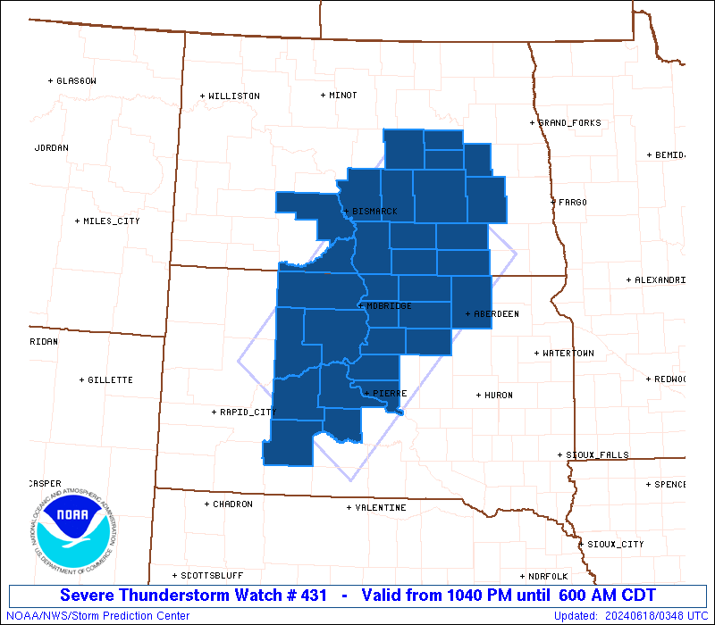
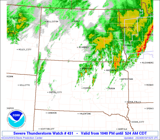
Severe Thunderstorm Watch Number 431
NWS Storm Prediction Center Norman OK
1040 PM CDT Mon Jun 17 2024
The NWS Storm Prediction Center has issued a
* Severe Thunderstorm Watch for portions of
South-central and east-central North Dakota
Central and northern South Dakota
* Effective this Monday night and Tuesday morning from 1040 PM
until 600 AM CDT.
* Primary threats include...
Scattered damaging winds and isolated significant gusts to 75
mph possible
Scattered large hail and isolated very large hail events to 2
inches in diameter possible
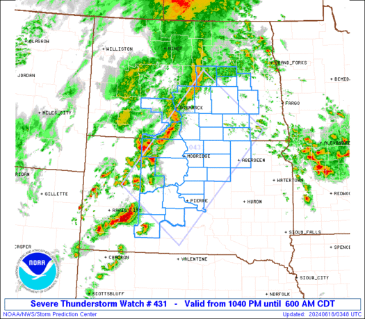
SUMMARY...Increasingly organized thunderstorms are expected to grow
in coverage and move northeastward across the watch area over the
next several hours. Though north of a warm front and nominally
elevated in character, this activity still may penetrate severe
gusts to the surface, as well as producing sporadic large hail.
The severe thunderstorm watch area is approximately along and 75
statute miles either side of a line from 70 miles west southwest of
Pierre SD to 5 miles north northeast of Jamestown ND. For a complete
depiction of the watch see the associated watch outline update
(WOUS64 KWNS WOU1).
PRECAUTIONARY/PREPAREDNESS ACTIONS...
REMEMBER...A Severe Thunderstorm Watch means conditions are
favorable for severe thunderstorms in and close to the watch area.
Persons in these areas should be on the lookout for threatening
weather conditions and listen for later statements and possible
warnings. Severe thunderstorms can and occasionally do produce
tornadoes.
&&
AVIATION...A few severe thunderstorms with hail surface and aloft to
2 inches. Extreme turbulence and surface wind gusts to 65 knots. A
few cumulonimbi with maximum tops to 500. Mean storm motion vector
23035.
...Edwards
   SEL1

   URGENT - IMMEDIATE BROADCAST REQUESTED
   Severe Thunderstorm Watch Number 431
   NWS Storm Prediction Center Norman OK
   1040 PM CDT Mon Jun 17 2024

   The NWS Storm Prediction Center has issued a

   * Severe Thunderstorm Watch for portions of
     South-central and east-central North Dakota
     Central and northern South Dakota

   * Effective this Monday night and Tuesday morning from 1040 PM
     until 600 AM CDT.

   * Primary threats include...
     Scattered damaging winds and isolated significant gusts to 75
       mph possible
     Scattered large hail and isolated very large hail events to 2
       inches in diameter possible

   SUMMARY...Increasingly organized thunderstorms are expected to grow
   in coverage and move northeastward across the watch area over the
   next several hours.  Though north of a warm front and nominally
   elevated in character, this activity still may penetrate severe
   gusts to the surface, as well as producing sporadic large hail.

   The severe thunderstorm watch area is approximately along and 75
   statute miles either side of a line from 70 miles west southwest of
   Pierre SD to 5 miles north northeast of Jamestown ND. For a complete
   depiction of the watch see the associated watch outline update
   (WOUS64 KWNS WOU1).

   PRECAUTIONARY/PREPAREDNESS ACTIONS...

   REMEMBER...A Severe Thunderstorm Watch means conditions are
   favorable for severe thunderstorms in and close to the watch area.
   Persons in these areas should be on the lookout for threatening
   weather conditions and listen for later statements and possible
   warnings. Severe thunderstorms can and occasionally do produce
   tornadoes.

   &&

   AVIATION...A few severe thunderstorms with hail surface and aloft to
   2 inches. Extreme turbulence and surface wind gusts to 65 knots. A
   few cumulonimbi with maximum tops to 500. Mean storm motion vector
   23035.

   ...Edwards
 Note:
The Aviation Watch (SAW) product is an approximation to the watch area.
The actual watch is depicted by the shaded areas.
Note:
The Aviation Watch (SAW) product is an approximation to the watch area.
The actual watch is depicted by the shaded areas.
   SAW1
   WW 431 SEVERE TSTM ND SD 180340Z - 181100Z
   AXIS..75 STATUTE MILES EITHER SIDE OF LINE..
   70WSW PIR/PIERRE SD/ - 5NNE JMS/JAMESTOWN ND/
   ..AVIATION COORDS.. 65NM EITHER SIDE /62E RAP - 75WNW FAR/
   HAIL SURFACE AND ALOFT..2 INCHES. WIND GUSTS..65 KNOTS.
   MAX TOPS TO 500. MEAN STORM MOTION VECTOR 23035.

   LAT...LON 44750265 47779977 46229754 43210054

   THIS IS AN APPROXIMATION TO THE WATCH AREA.  FOR A
   COMPLETE DEPICTION OF THE WATCH SEE WOUS64 KWNS
   FOR WOU1.
Watch 431 Status Report Messages:
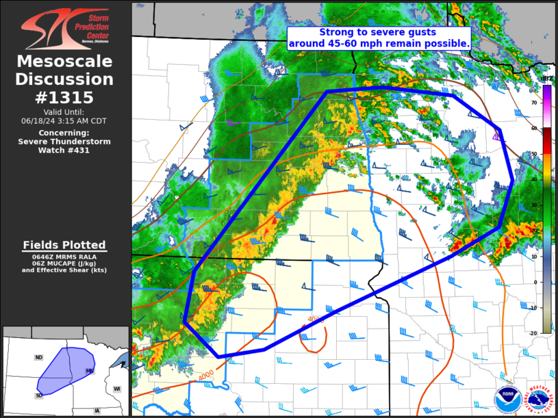
STATUS REPORT #6 ON WW 431

VALID 180935Z - 181040Z

SEVERE WEATHER THREAT CONTINUES RIGHT OF A LINE FROM 45 NW HON TO
55 SE MBG TO 35 W ABR TO 50 SW FAR TO 20 SSE FAR.

..LEITMAN..06/18/24

ATTN...WFO...FGF...BIS...ABR...UNR...

&&

STATUS REPORT FOR WS 431

SEVERE WEATHER THREAT CONTINUES FOR THE FOLLOWING AREAS

NDC073-077-081-181040-

ND
.    NORTH DAKOTA COUNTIES INCLUDED ARE

RANSOM		     RICHLAND		 SARGENT
$$


SDC013-045-049-089-181040-

SD
.    SOUTH DAKOTA COUNTIES INCLUDED ARE

BROWN		     EDMUNDS		 FAULK
MCPHERSON
$$


THE WATCH STATUS MESSAGE IS FOR GUIDANCE PURPOSES ONLY.  PLEASE
REFER TO WATCH COUNTY NOTIFICATION STATEMENTS FOR OFFICIAL
INFORMATION ON COUNTIES...INDEPENDENT CITIES AND MARINE ZONES
CLEARED FROM SEVERE THUNDERSTORM AND TORNADO WATCHES.
$$

STATUS REPORT #5 ON WW 431

VALID 180845Z - 180940Z

SEVERE WEATHER THREAT CONTINUES RIGHT OF A LINE FROM 30 SE PIR TO
15 NNW PHP TO 35 ESE MBG TO 45 N ABR TO 35 N FAR.

..LEITMAN..06/18/24

ATTN...WFO...FGF...BIS...ABR...UNR...

&&

STATUS REPORT FOR WS 431

SEVERE WEATHER THREAT CONTINUES FOR THE FOLLOWING AREAS

NDC017-073-077-081-180940-

ND
.    NORTH DAKOTA COUNTIES INCLUDED ARE

CASS		     RANSOM		 RICHLAND
SARGENT
$$


SDC013-045-049-055-065-089-107-117-119-129-180940-

SD
.    SOUTH DAKOTA COUNTIES INCLUDED ARE

BROWN		     EDMUNDS		 FAULK
HAAKON		     HUGHES		 MCPHERSON
POTTER		     STANLEY		 SULLY
WALWORTH
$$


THE WATCH STATUS MESSAGE IS FOR GUIDANCE PURPOSES ONLY.  PLEASE
REFER TO WATCH COUNTY NOTIFICATION STATEMENTS FOR OFFICIAL
INFORMATION ON COUNTIES...INDEPENDENT CITIES AND MARINE ZONES
CLEARED FROM SEVERE THUNDERSTORM AND TORNADO WATCHES.
$$

STATUS REPORT #4 ON WW 431

VALID 180750Z - 180840Z

SEVERE WEATHER THREAT CONTINUES RIGHT OF A LINE FROM 30 WNW PHP
TO 15 S MBG TO 45 E JMS TO 5 SE GFK TO 15 S HCO.

..LEITMAN..06/18/24

ATTN...WFO...FGF...BIS...ABR...UNR...

&&

STATUS REPORT FOR WS 431

SEVERE WEATHER THREAT CONTINUES FOR THE FOLLOWING AREAS

NDC003-017-021-045-073-077-081-097-180840-

ND
.    NORTH DAKOTA COUNTIES INCLUDED ARE

BARNES		     CASS		 DICKEY
LAMOURE 	     RANSOM		 RICHLAND
SARGENT 	     TRAILL
$$


SDC013-045-049-055-065-071-075-089-107-117-119-129-180840-

SD
.    SOUTH DAKOTA COUNTIES INCLUDED ARE

BROWN		     EDMUNDS		 FAULK
HAAKON		     HUGHES		 JACKSON
JONES		     MCPHERSON		 POTTER
STANLEY 	     SULLY		 WALWORTH
$$


THE WATCH STATUS MESSAGE IS FOR GUIDANCE PURPOSES ONLY.  PLEASE
REFER TO WATCH COUNTY NOTIFICATION STATEMENTS FOR OFFICIAL
INFORMATION ON COUNTIES...INDEPENDENT CITIES AND MARINE ZONES
CLEARED FROM SEVERE THUNDERSTORM AND TORNADO WATCHES.
$$

STATUS REPORT #3 ON WW 431

VALID 180635Z - 180740Z

SEVERE WEATHER THREAT CONTINUES RIGHT OF A LINE FROM 45 NE RAP TO
50 NNE MBG TO 40 WSW GFK TO 25 NNE GFK.

..LEITMAN..06/18/24

ATTN...WFO...FGF...BIS...ABR...UNR...

&&

STATUS REPORT FOR WS 431

SEVERE WEATHER THREAT CONTINUES FOR THE FOLLOWING AREAS

NDC003-017-021-035-039-045-047-051-073-077-081-091-093-097-
180740-

ND
.    NORTH DAKOTA COUNTIES INCLUDED ARE

BARNES		     CASS		 DICKEY
GRAND FORKS	     GRIGGS		 LAMOURE
LOGAN		     MCINTOSH		 RANSOM
RICHLAND	     SARGENT		 STEELE
STUTSMAN	     TRAILL
$$


SDC013-021-041-045-049-055-065-071-075-089-107-117-119-129-137-
180740-

SD
.    SOUTH DAKOTA COUNTIES INCLUDED ARE

BROWN		     CAMPBELL		 DEWEY
EDMUNDS 	     FAULK		 HAAKON
HUGHES		     JACKSON		 JONES
MCPHERSON	     POTTER		 STANLEY
SULLY		     WALWORTH		 ZIEBACH
$$


THE WATCH STATUS MESSAGE IS FOR GUIDANCE PURPOSES ONLY.  PLEASE
REFER TO WATCH COUNTY NOTIFICATION STATEMENTS FOR OFFICIAL
INFORMATION ON COUNTIES...INDEPENDENT CITIES AND MARINE ZONES
CLEARED FROM SEVERE THUNDERSTORM AND TORNADO WATCHES.
$$

STATUS REPORT #2 ON WW 431

VALID 180540Z - 180640Z

SEVERE WEATHER THREAT CONTINUES RIGHT OF A LINE FROM 40 NE RAP TO
35 ESE BIS TO 40 NNW JMS.

..LEITMAN..06/18/24

ATTN...WFO...FGF...BIS...ABR...UNR...

&&

STATUS REPORT FOR WS 431

SEVERE WEATHER THREAT CONTINUES FOR THE FOLLOWING AREAS

NDC003-021-027-029-031-039-043-045-047-051-093-180640-

ND
.    NORTH DAKOTA COUNTIES INCLUDED ARE

BARNES		     DICKEY		 EDDY
EMMONS		     FOSTER		 GRIGGS
KIDDER		     LAMOURE		 LOGAN
MCINTOSH	     STUTSMAN
$$


SDC013-021-031-041-045-049-055-065-071-075-089-107-117-119-129-
137-180640-

SD
.    SOUTH DAKOTA COUNTIES INCLUDED ARE

BROWN		     CAMPBELL		 CORSON
DEWEY		     EDMUNDS		 FAULK
HAAKON		     HUGHES		 JACKSON
JONES		     MCPHERSON		 POTTER
STANLEY 	     SULLY		 WALWORTH
ZIEBACH
$$


THE WATCH STATUS MESSAGE IS FOR GUIDANCE PURPOSES ONLY.  PLEASE
REFER TO WATCH COUNTY NOTIFICATION STATEMENTS FOR OFFICIAL
INFORMATION ON COUNTIES...INDEPENDENT CITIES AND MARINE ZONES
CLEARED FROM SEVERE THUNDERSTORM AND TORNADO WATCHES.
$$

STATUS REPORT #1 ON WW 431

VALID 180440Z - 180540Z

THE SEVERE WEATHER THREAT CONTINUES ACROSS THE ENTIRE WATCH AREA.

..DEAN..06/18/24

ATTN...WFO...FGF...BIS...ABR...UNR...

&&

STATUS REPORT FOR WS 431

SEVERE WEATHER THREAT CONTINUES FOR THE FOLLOWING AREAS

NDC003-015-021-027-029-031-039-043-045-047-051-059-085-093-103-
180540-

ND
.    NORTH DAKOTA COUNTIES INCLUDED ARE

BARNES		     BURLEIGH		 DICKEY
EDDY		     EMMONS		 FOSTER
GRIGGS		     KIDDER		 LAMOURE
LOGAN		     MCINTOSH		 MORTON
SIOUX		     STUTSMAN		 WELLS
$$


SDC013-021-031-041-045-049-055-065-071-075-089-107-117-119-129-
137-180540-

SD
.    SOUTH DAKOTA COUNTIES INCLUDED ARE

BROWN		     CAMPBELL		 CORSON
DEWEY		     EDMUNDS		 FAULK
HAAKON		     HUGHES		 JACKSON
JONES		     MCPHERSON		 POTTER
STANLEY 	     SULLY		 WALWORTH
ZIEBACH
$$


THE WATCH STATUS MESSAGE IS FOR GUIDANCE PURPOSES ONLY.  PLEASE
REFER TO WATCH COUNTY NOTIFICATION STATEMENTS FOR OFFICIAL
INFORMATION ON COUNTIES...INDEPENDENT CITIES AND MARINE ZONES
CLEARED FROM SEVERE THUNDERSTORM AND TORNADO WATCHES.
$$
Note:
Click for Complete Product Text.
Tornadoes
Probability of 2 or more tornadoes
|
Low (<5%)
|
Probability of 1 or more strong (EF2-EF5) tornadoes
|
Low (<2%)
|
Wind
Probability of 10 or more severe wind events
|
Mod (40%)
|
Probability of 1 or more wind events > 65 knots
|
Mod (30%)
|
Hail
Probability of 10 or more severe hail events
|
Mod (50%)
|
Probability of 1 or more hailstones > 2 inches
|
Mod (30%)
|
Combined Severe Hail/Wind
Probability of 6 or more combined severe hail/wind events
|
High (80%)
|
For each watch, probabilities for particular events inside the watch
(listed above in each table) are determined by the issuing forecaster.
The "Low" category contains probability values ranging from less than 2%
to 20% (EF2-EF5 tornadoes), less than 5% to 20% (all other probabilities),
"Moderate" from 30% to 60%, and "High" from 70% to greater than 95%.
High values are bolded and lighter in color to provide awareness of
an increased threat for a particular event.


 @NWSSPC