 Note:
The expiration time in the watch graphic is amended if the watch is
replaced, cancelled or extended.
Note:
Note:
The expiration time in the watch graphic is amended if the watch is
replaced, cancelled or extended.
Note: Click for
Watch Status Reports.
SEL9
URGENT - IMMEDIATE BROADCAST REQUESTED
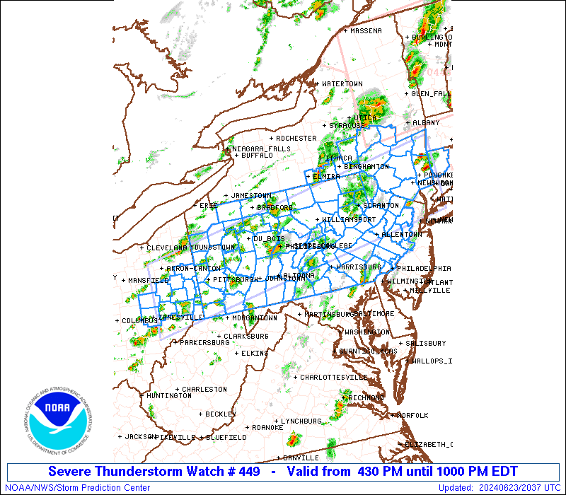
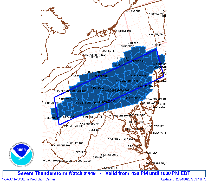
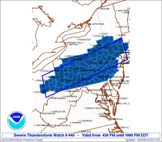
Severe Thunderstorm Watch Number 449
NWS Storm Prediction Center Norman OK
430 PM EDT Sun Jun 23 2024
The NWS Storm Prediction Center has issued a
* Severe Thunderstorm Watch for portions of
Western Connecticut
Western New Jersey
Southeast New York
East Central Ohio
Pennsylvania
Northern Panhandle of West Virginia
* Effective this Sunday afternoon and evening from 430 PM until
1000 PM EDT.
* Primary threats include...
Scattered damaging wind gusts to 70 mph likely
Isolated large hail events to 1.5 inches in diameter possible
A tornado or two possible
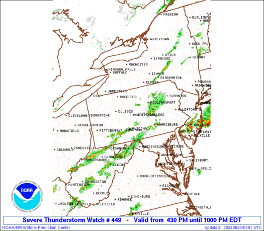
SUMMARY...Widely scattered strong to severe thunderstorms will
affect the watch area through the afternoon and evening. The
strongest cells will occasionally pose a risk of damaging wind
gusts.
The severe thunderstorm watch area is approximately along and 55
statute miles north and south of a line from 50 miles south
southwest of Akron OH to 25 miles east of Poughkeepsie NY. For a
complete depiction of the watch see the associated watch outline
update (WOUS64 KWNS WOU9).
PRECAUTIONARY/PREPAREDNESS ACTIONS...
REMEMBER...A Severe Thunderstorm Watch means conditions are
favorable for severe thunderstorms in and close to the watch area.
Persons in these areas should be on the lookout for threatening
weather conditions and listen for later statements and possible
warnings. Severe thunderstorms can and occasionally do produce
tornadoes.
&&
OTHER WATCH INFORMATION...CONTINUE...WW 448...
AVIATION...A few severe thunderstorms with hail surface and aloft to
1.5 inches. Extreme turbulence and surface wind gusts to 60 knots. A
few cumulonimbi with maximum tops to 500. Mean storm motion vector
27030.
...Hart
 Note:
The Aviation Watch (SAW) product is an approximation to the watch area.
The actual watch is depicted by the shaded areas.
Note:
The Aviation Watch (SAW) product is an approximation to the watch area.
The actual watch is depicted by the shaded areas.
   SAW9
   WW 449 SEVERE TSTM CT NJ NY OH PA WV 232030Z - 240200Z
   AXIS..55 STATUTE MILES NORTH AND SOUTH OF LINE..
   50SSW CAK/AKRON OH/ - 25E POU/POUGHKEEPSIE NY/
   ..AVIATION COORDS.. 50NM N/S /37E APE - 37WSW BDL/
   HAIL SURFACE AND ALOFT..1.5 INCHES. WIND GUSTS..60 KNOTS.
   MAX TOPS TO 500. MEAN STORM MOTION VECTOR 27030.

   LAT...LON 41058179 42427340 40837340 39458179

   THIS IS AN APPROXIMATION TO THE WATCH AREA.  FOR A
   COMPLETE DEPICTION OF THE WATCH SEE WOUS64 KWNS
   FOR WOU9.
Watch 449 Status Report Messages:
STATUS REPORT #4 ON WW 449
VALID 240120Z - 240200Z
SEVERE WEATHER THREAT CONTINUES RIGHT OF A LINE FROM 15 WNW MGW
TO 25 E LBE TO 25 NE AOO TO 25 SW IPT TO 10 E AVP TO 5 N EWR.
REMAINING VALID PORTION OF WW 449 MAY BE ALLOWED TO EXPIRE AT
24/02Z.
..KERR..06/24/24
ATTN...WFO...ALY...PHI...BGM...OKX...PBZ...CTP...
&&
STATUS REPORT FOR WS 449
SEVERE WEATHER THREAT CONTINUES FOR THE FOLLOWING AREAS
NJC001-005-007-009-011-015-019-021-023-025-027-029-033-035-041-
240200-
NJ
. NEW JERSEY COUNTIES INCLUDED ARE
ATLANTIC BURLINGTON CAMDEN
CAPE MAY CUMBERLAND GLOUCESTER
HUNTERDON MERCER MIDDLESEX
MONMOUTH MORRIS OCEAN
SALEM SOMERSET WARREN
$$
PAC001-009-011-013-017-025-027-029-037-041-043-045-051-055-057-
059-061-067-071-075-077-079-087-089-091-093-095-097-099-101-107-
109-111-119-133-240200-
PA
. PENNSYLVANIA COUNTIES INCLUDED ARE
ADAMS BEDFORD BERKS
BLAIR BUCKS CARBON
CENTRE CHESTER COLUMBIA
CUMBERLAND DAUPHIN DELAWARE
FAYETTE FRANKLIN FULTON
GREENE HUNTINGDON JUNIATA
LANCASTER LEBANON LEHIGH
LUZERNE MIFFLIN MONROE
MONTGOMERY MONTOUR NORTHAMPTON
NORTHUMBERLAND PERRY PHILADELPHIA
SCHUYLKILL SNYDER SOMERSET
UNION YORK
$$
ANZ431-240200-
CW
. ADJACENT COASTAL WATERS INCLUDED ARE
ANZ431
$$
THE WATCH STATUS MESSAGE IS FOR GUIDANCE PURPOSES ONLY. PLEASE
REFER TO WATCH COUNTY NOTIFICATION STATEMENTS FOR OFFICIAL
INFORMATION ON COUNTIES...INDEPENDENT CITIES AND MARINE ZONES
CLEARED FROM SEVERE THUNDERSTORM AND TORNADO WATCHES.
$$
STATUS REPORT #3 ON WW 449
VALID 240025Z - 240140Z
SEVERE WEATHER THREAT CONTINUES RIGHT OF A LINE FROM 25 SSE ZZV
TO 25 NNW AOO TO 25 WSW IPT TO 10 WNW AVP TO 40 NNE MSV.
..KERR..06/24/24
ATTN...WFO...ALY...PHI...BGM...OKX...PBZ...CTP...
&&
STATUS REPORT FOR WS 449
SEVERE WEATHER THREAT CONTINUES FOR THE FOLLOWING AREAS
CTC005-240140-
CT
. CONNECTICUT COUNTIES INCLUDED ARE
LITCHFIELD
$$
NJC001-005-007-009-011-015-019-021-023-025-027-029-033-035-037-
041-240140-
NJ
. NEW JERSEY COUNTIES INCLUDED ARE
ATLANTIC BURLINGTON CAMDEN
CAPE MAY CUMBERLAND GLOUCESTER
HUNTERDON MERCER MIDDLESEX
MONMOUTH MORRIS OCEAN
SALEM SOMERSET SUSSEX
WARREN
$$
NYC021-027-039-105-111-240140-
NY
. NEW YORK COUNTIES INCLUDED ARE
COLUMBIA DUTCHESS GREENE
SULLIVAN ULSTER
$$
PAC001-009-011-013-017-021-025-027-029-037-041-043-045-051-055-
057-059-061-067-069-071-075-077-079-087-089-091-093-095-097-099-
101-103-107-109-111-119-127-129-133-240140-
PA
. PENNSYLVANIA COUNTIES INCLUDED ARE
ADAMS BEDFORD BERKS
BLAIR BUCKS CAMBRIA
CARBON CENTRE CHESTER
COLUMBIA CUMBERLAND DAUPHIN
DELAWARE FAYETTE FRANKLIN
FULTON GREENE HUNTINGDON
JUNIATA LACKAWANNA LANCASTER
LEBANON LEHIGH LUZERNE
MIFFLIN MONROE MONTGOMERY
MONTOUR NORTHAMPTON NORTHUMBERLAND
PERRY PHILADELPHIA PIKE
SCHUYLKILL SNYDER SOMERSET
UNION WAYNE WESTMORELAND
YORK
$$
WVC051-240140-
WV
. WEST VIRGINIA COUNTIES INCLUDED ARE
MARSHALL
$$
ANZ431-240140-
CW
. ADJACENT COASTAL WATERS INCLUDED ARE
ANZ431
$$
THE WATCH STATUS MESSAGE IS FOR GUIDANCE PURPOSES ONLY. PLEASE
REFER TO WATCH COUNTY NOTIFICATION STATEMENTS FOR OFFICIAL
INFORMATION ON COUNTIES...INDEPENDENT CITIES AND MARINE ZONES
CLEARED FROM SEVERE THUNDERSTORM AND TORNADO WATCHES.
$$
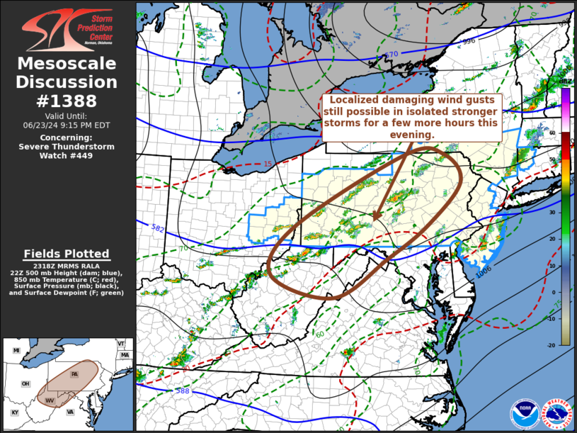
STATUS REPORT #2 ON WW 449
VALID 232330Z - 240040Z
SEVERE WEATHER THREAT CONTINUES RIGHT OF A LINE FROM 5 E ZZV TO
35 WNW HLG TO 20 E DUJ TO 30 N UNV TO 20 SSE ELM.
FOR ADDITIONAL INFORMATION SEE MESOSCALE DISCUSSION 1388.
..KERR..06/23/24
ATTN...WFO...ALY...PHI...BGM...OKX...PBZ...CTP...
&&
STATUS REPORT FOR WS 449
SEVERE WEATHER THREAT CONTINUES FOR THE FOLLOWING AREAS
CTC005-240040-
CT
. CONNECTICUT COUNTIES INCLUDED ARE
LITCHFIELD
$$
NJC001-005-007-009-011-015-019-021-023-025-027-029-033-035-037-
041-240040-
NJ
. NEW JERSEY COUNTIES INCLUDED ARE
ATLANTIC BURLINGTON CAMDEN
CAPE MAY CUMBERLAND GLOUCESTER
HUNTERDON MERCER MIDDLESEX
MONMOUTH MORRIS OCEAN
SALEM SOMERSET SUSSEX
WARREN
$$
NYC007-017-021-025-027-039-071-077-079-095-105-107-111-240040-
NY
. NEW YORK COUNTIES INCLUDED ARE
BROOME CHENANGO COLUMBIA
DELAWARE DUTCHESS GREENE
ORANGE OTSEGO PUTNAM
SCHOHARIE SULLIVAN TIOGA
ULSTER
$$
OHC013-059-067-081-240040-
OH
. OHIO COUNTIES INCLUDED ARE
BELMONT GUERNSEY HARRISON
JEFFERSON
$$
PAC001-003-005-009-011-013-015-017-021-025-027-029-033-035-037-
041-043-045-051-055-057-059-061-063-067-069-071-075-077-079-081-
087-089-091-093-095-097-099-101-103-107-109-111-113-115-119-125-
127-129-131-133-240040-
PA
. PENNSYLVANIA COUNTIES INCLUDED ARE
ADAMS ALLEGHENY ARMSTRONG
BEDFORD BERKS BLAIR
BRADFORD BUCKS CAMBRIA
CARBON CENTRE CHESTER
CLEARFIELD CLINTON COLUMBIA
CUMBERLAND DAUPHIN DELAWARE
FAYETTE FRANKLIN FULTON
GREENE HUNTINGDON INDIANA
JUNIATA LACKAWANNA LANCASTER
LEBANON LEHIGH LUZERNE
LYCOMING MIFFLIN MONROE
MONTGOMERY MONTOUR NORTHAMPTON
NORTHUMBERLAND PERRY PHILADELPHIA
PIKE SCHUYLKILL SNYDER
SOMERSET SULLIVAN SUSQUEHANNA
UNION WASHINGTON WAYNE
WESTMORELAND WYOMING YORK
$$
WVC009-029-051-069-240040-
WV
. WEST VIRGINIA COUNTIES INCLUDED ARE
BROOKE HANCOCK MARSHALL
OHIO
$$
ANZ431-240040-
CW
. ADJACENT COASTAL WATERS INCLUDED ARE
ANZ431
$$
THE WATCH STATUS MESSAGE IS FOR GUIDANCE PURPOSES ONLY. PLEASE
REFER TO WATCH COUNTY NOTIFICATION STATEMENTS FOR OFFICIAL
INFORMATION ON COUNTIES...INDEPENDENT CITIES AND MARINE ZONES
CLEARED FROM SEVERE THUNDERSTORM AND TORNADO WATCHES.
$$
STATUS REPORT #1 ON WW 449
VALID 232235Z - 232340Z
SEVERE WEATHER THREAT CONTINUES RIGHT OF A LINE FROM 30 SW CAK TO
10 E FKL.
..KERR..06/23/24
ATTN...WFO...ALY...PHI...BGM...OKX...PBZ...CTP...
&&
STATUS REPORT FOR WS 449
SEVERE WEATHER THREAT CONTINUES FOR THE FOLLOWING AREAS
CTC005-232340-
CT
. CONNECTICUT COUNTIES INCLUDED ARE
LITCHFIELD
$$
NJC001-005-007-009-011-015-019-021-023-025-027-029-033-035-037-
041-232340-
NJ
. NEW JERSEY COUNTIES INCLUDED ARE
ATLANTIC BURLINGTON CAMDEN
CAPE MAY CUMBERLAND GLOUCESTER
HUNTERDON MERCER MIDDLESEX
MONMOUTH MORRIS OCEAN
SALEM SOMERSET SUSSEX
WARREN
$$
NYC007-017-021-025-027-039-071-077-079-095-105-107-111-232340-
NY
. NEW YORK COUNTIES INCLUDED ARE
BROOME CHENANGO COLUMBIA
DELAWARE DUTCHESS GREENE
ORANGE OTSEGO PUTNAM
SCHOHARIE SULLIVAN TIOGA
ULSTER
$$
OHC013-019-029-031-059-067-081-119-157-232340-
OH
. OHIO COUNTIES INCLUDED ARE
BELMONT CARROLL COLUMBIANA
COSHOCTON GUERNSEY HARRISON
JEFFERSON MUSKINGUM TUSCARAWAS
$$
PAC001-003-005-007-009-011-013-015-017-019-021-023-025-027-029-
031-033-035-037-041-043-045-047-051-055-057-059-061-063-065-067-
069-071-073-075-077-079-081-087-089-091-093-095-097-099-101-103-
107-109-111-113-115-117-119-125-127-129-131-133-232340-
PA
. PENNSYLVANIA COUNTIES INCLUDED ARE
ADAMS ALLEGHENY ARMSTRONG
BEAVER BEDFORD BERKS
BLAIR BRADFORD BUCKS
BUTLER CAMBRIA CAMERON
CARBON CENTRE CHESTER
CLARION CLEARFIELD CLINTON
COLUMBIA CUMBERLAND DAUPHIN
DELAWARE ELK FAYETTE
FRANKLIN FULTON GREENE
HUNTINGDON INDIANA JEFFERSON
JUNIATA LACKAWANNA LANCASTER
LAWRENCE LEBANON LEHIGH
LUZERNE LYCOMING MIFFLIN
MONROE MONTGOMERY MONTOUR
NORTHAMPTON NORTHUMBERLAND PERRY
PHILADELPHIA PIKE SCHUYLKILL
SNYDER SOMERSET SULLIVAN
SUSQUEHANNA TIOGA UNION
WASHINGTON WAYNE WESTMORELAND
WYOMING YORK
$$
WVC009-029-051-069-232340-
WV
. WEST VIRGINIA COUNTIES INCLUDED ARE
BROOKE HANCOCK MARSHALL
OHIO
$$
ANZ431-232340-
CW
. ADJACENT COASTAL WATERS INCLUDED ARE
ANZ431
$$
THE WATCH STATUS MESSAGE IS FOR GUIDANCE PURPOSES ONLY. PLEASE
REFER TO WATCH COUNTY NOTIFICATION STATEMENTS FOR OFFICIAL
INFORMATION ON COUNTIES...INDEPENDENT CITIES AND MARINE ZONES
CLEARED FROM SEVERE THUNDERSTORM AND TORNADO WATCHES.
$$
Note:
Click for Complete Product Text.
Tornadoes
Probability of 2 or more tornadoes
|
Low (20%)
|
Probability of 1 or more strong (EF2-EF5) tornadoes
|
Low (5%)
|
Wind
Probability of 10 or more severe wind events
|
Mod (60%)
|
Probability of 1 or more wind events > 65 knots
|
Low (20%)
|
Hail
Probability of 10 or more severe hail events
|
Low (20%)
|
Probability of 1 or more hailstones > 2 inches
|
Low (10%)
|
Combined Severe Hail/Wind
Probability of 6 or more combined severe hail/wind events
|
High (80%)
|
For each watch, probabilities for particular events inside the watch
(listed above in each table) are determined by the issuing forecaster.
The "Low" category contains probability values ranging from less than 2%
to 20% (EF2-EF5 tornadoes), less than 5% to 20% (all other probabilities),
"Moderate" from 30% to 60%, and "High" from 70% to greater than 95%.
High values are bolded and lighter in color to provide awareness of
an increased threat for a particular event.


 @NWSSPC