Note:
The expiration time in the watch graphic is amended if the watch is
replaced, cancelled or extended.
Note:
Note:
The expiration time in the watch graphic is amended if the watch is
replaced, cancelled or extended.
Note: Click for
Watch Status Reports.
SEL9
URGENT - IMMEDIATE BROADCAST REQUESTED
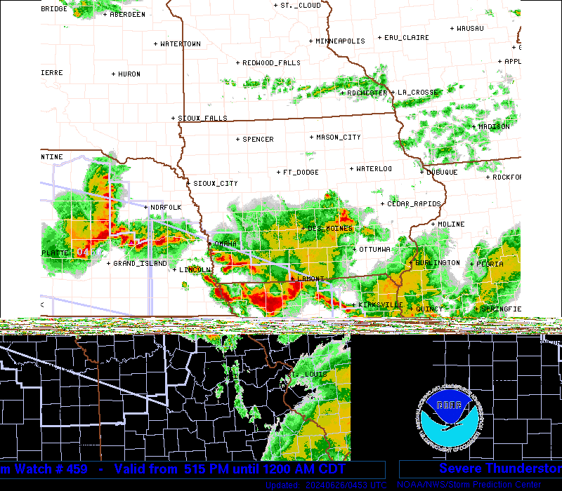
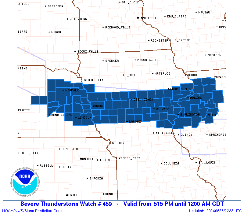
Severe Thunderstorm Watch Number 459
NWS Storm Prediction Center Norman OK
515 PM CDT Tue Jun 25 2024
The NWS Storm Prediction Center has issued a
* Severe Thunderstorm Watch for portions of
Southern Iowa
Northern Illinois
Far Northeast Missouri
Eastern Nebraska
* Effective this Tuesday afternoon from 515 PM until Midnight
CDT.
* Primary threats include...
Scattered large hail likely with isolated very large hail events
to 2.5 inches in diameter possible
Scattered damaging wind gusts to 70 mph likely
A tornado or two possible
SUMMARY...Robust thunderstorms will continue to develop and slowly
sag east-southeastward late this afternoon and evening. Large to
very large hail around 1.5-2.5 inches in diameter along with 60-70
mph wind gusts should be the main threats. A brief landspout tornado
or two may also occur.
The severe thunderstorm watch area is approximately along and 40
statute miles north and south of a line from 45 miles west southwest
of Norfolk NE to 20 miles northeast of Peoria IL. For a complete
depiction of the watch see the associated watch outline update
(WOUS64 KWNS WOU9).
PRECAUTIONARY/PREPAREDNESS ACTIONS...
REMEMBER...A Severe Thunderstorm Watch means conditions are
favorable for severe thunderstorms in and close to the watch area.
Persons in these areas should be on the lookout for threatening
weather conditions and listen for later statements and possible
warnings. Severe thunderstorms can and occasionally do produce
tornadoes.
&&
OTHER WATCH INFORMATION...CONTINUE...WW 457...WW 458...
AVIATION...A few severe thunderstorms with hail surface and aloft to
2.5 inches. Extreme turbulence and surface wind gusts to 60 knots. A
few cumulonimbi with maximum tops to 550. Mean storm motion vector
31025.
...Gleason
 Note:
The Aviation Watch (SAW) product is an approximation to the watch area.
The actual watch is depicted by the shaded areas.
Note:
The Aviation Watch (SAW) product is an approximation to the watch area.
The actual watch is depicted by the shaded areas.
   SAW9
   WW 459 SEVERE TSTM IA IL MO NE 252215Z - 260500Z
   AXIS..40 STATUTE MILES NORTH AND SOUTH OF LINE..
   45WSW OFK/NORFOLK NE/ - 20NE PIA/PEORIA IL/
   ..AVIATION COORDS.. 35NM N/S /22NNE OBH - 19SSE BDF/
   HAIL SURFACE AND ALOFT..2.5 INCHES. WIND GUSTS..60 KNOTS.
   MAX TOPS TO 550. MEAN STORM MOTION VECTOR 31025.

   LAT...LON 42319824 41458941 40308941 41159824

   THIS IS AN APPROXIMATION TO THE WATCH AREA.  FOR A
   COMPLETE DEPICTION OF THE WATCH SEE WOUS64 KWNS
   FOR WOU9.
Watch 459 Status Report Messages:
STATUS REPORT #4 ON WW 459
VALID 260340Z - 260440Z
SEVERE WEATHER THREAT CONTINUES RIGHT OF A LINE FROM 30 NNE DSM
TO 20 WNW OTM TO 30 N IRK.
..GOSS..06/26/24
ATTN...WFO...DMX...DVN...OAX...ILX...LOT...GID...
&&
STATUS REPORT FOR WS 459
SEVERE WEATHER THREAT CONTINUES FOR THE FOLLOWING AREAS
IAC001-003-007-009-029-039-049-053-071-077-085-117-121-125-129-
133-135-137-145-153-155-159-165-173-175-181-185-260440-
IA
. IOWA COUNTIES INCLUDED ARE
ADAIR ADAMS APPANOOSE
AUDUBON CASS CLARKE
DALLAS DECATUR FREMONT
GUTHRIE HARRISON LUCAS
MADISON MARION MILLS
MONONA MONROE MONTGOMERY
PAGE POLK POTTAWATTAMIE
RINGGOLD SHELBY TAYLOR
UNION WARREN WAYNE
$$
NEC003-011-021-023-025-027-037-039-053-055-077-107-109-119-121-
125-131-139-141-143-153-155-159-167-173-175-177-179-260440-
NE
. NEBRASKA COUNTIES INCLUDED ARE
ANTELOPE BOONE BURT
BUTLER CASS CEDAR
COLFAX CUMING DODGE
DOUGLAS GREELEY KNOX
LANCASTER MADISON MERRICK
NANCE OTOE PIERCE
PLATTE POLK SARPY
SAUNDERS SEWARD STANTON
THURSTON VALLEY WASHINGTON
WAYNE
$$
THE WATCH STATUS MESSAGE IS FOR GUIDANCE PURPOSES ONLY. PLEASE
REFER TO WATCH COUNTY NOTIFICATION STATEMENTS FOR OFFICIAL
INFORMATION ON COUNTIES...INDEPENDENT CITIES AND MARINE ZONES
CLEARED FROM SEVERE THUNDERSTORM AND TORNADO WATCHES.
$$
STATUS REPORT #3 ON WW 459
VALID 260140Z - 260240Z
THE SEVERE WEATHER THREAT CONTINUES ACROSS THE ENTIRE WATCH AREA.
..GOSS..06/26/24
ATTN...WFO...DMX...DVN...OAX...ILX...LOT...GID...
&&
STATUS REPORT FOR WS 459
SEVERE WEATHER THREAT CONTINUES FOR THE FOLLOWING AREAS
ILC011-015-057-067-071-073-095-099-103-109-123-131-141-143-155-
161-175-179-187-195-203-260240-
IL
. ILLINOIS COUNTIES INCLUDED ARE
BUREAU CARROLL FULTON
HANCOCK HENDERSON HENRY
KNOX LA SALLE LEE
MCDONOUGH MARSHALL MERCER
OGLE PEORIA PUTNAM
ROCK ISLAND STARK TAZEWELL
WARREN WHITESIDE WOODFORD
$$
IAC001-003-007-009-029-031-039-045-049-051-053-057-071-077-085-
087-095-099-101-103-107-111-115-117-121-123-125-129-133-135-137-
139-145-153-155-157-159-163-165-173-175-177-179-181-183-185-
260240-
IA
. IOWA COUNTIES INCLUDED ARE
ADAIR ADAMS APPANOOSE
AUDUBON CASS CEDAR
CLARKE CLINTON DALLAS
DAVIS DECATUR DES MOINES
FREMONT GUTHRIE HARRISON
HENRY IOWA JASPER
JEFFERSON JOHNSON KEOKUK
LEE LOUISA LUCAS
MADISON MAHASKA MARION
MILLS MONONA MONROE
MONTGOMERY MUSCATINE PAGE
POLK POTTAWATTAMIE POWESHIEK
RINGGOLD SCOTT SHELBY
TAYLOR UNION VAN BUREN
WAPELLO WARREN WASHINGTON
WAYNE
$$
MOC045-199-260240-
MO
. MISSOURI COUNTIES INCLUDED ARE
CLARK SCOTLAND
$$
NEC003-011-021-023-025-037-039-053-055-077-109-119-121-125-131-
139-141-143-153-155-159-167-173-175-177-179-260240-
NE
. NEBRASKA COUNTIES INCLUDED ARE
ANTELOPE BOONE BURT
BUTLER CASS COLFAX
CUMING DODGE DOUGLAS
GREELEY LANCASTER MADISON
MERRICK NANCE OTOE
PIERCE PLATTE POLK
SARPY SAUNDERS SEWARD
STANTON THURSTON VALLEY
WASHINGTON WAYNE
$$
THE WATCH STATUS MESSAGE IS FOR GUIDANCE PURPOSES ONLY. PLEASE
REFER TO WATCH COUNTY NOTIFICATION STATEMENTS FOR OFFICIAL
INFORMATION ON COUNTIES...INDEPENDENT CITIES AND MARINE ZONES
CLEARED FROM SEVERE THUNDERSTORM AND TORNADO WATCHES.
$$
STATUS REPORT #2 ON WW 459
VALID 260035Z - 260140Z
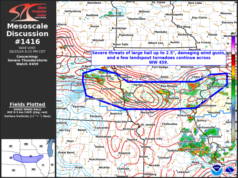
THE SEVERE WEATHER THREAT CONTINUES ACROSS THE ENTIRE WATCH AREA.
FOR ADDITIONAL INFORMATION SEE MESOSCALE DISCUSSION 1416
..WENDT..06/26/24
ATTN...WFO...DMX...DVN...OAX...ILX...LOT...GID...
&&
STATUS REPORT FOR WS 459
SEVERE WEATHER THREAT CONTINUES FOR THE FOLLOWING AREAS
ILC011-015-057-067-071-073-095-099-103-109-123-131-141-143-155-
161-175-179-187-195-203-260140-
IL
. ILLINOIS COUNTIES INCLUDED ARE
BUREAU CARROLL FULTON
HANCOCK HENDERSON HENRY
KNOX LA SALLE LEE
MCDONOUGH MARSHALL MERCER
OGLE PEORIA PUTNAM
ROCK ISLAND STARK TAZEWELL
WARREN WHITESIDE WOODFORD
$$
IAC001-003-007-009-029-031-039-045-049-051-053-057-071-077-085-
087-095-099-101-103-107-111-115-117-121-123-125-129-133-135-137-
139-145-153-155-157-159-163-165-173-175-177-179-181-183-185-
260140-
IA
. IOWA COUNTIES INCLUDED ARE
ADAIR ADAMS APPANOOSE
AUDUBON CASS CEDAR
CLARKE CLINTON DALLAS
DAVIS DECATUR DES MOINES
FREMONT GUTHRIE HARRISON
HENRY IOWA JASPER
JEFFERSON JOHNSON KEOKUK
LEE LOUISA LUCAS
MADISON MAHASKA MARION
MILLS MONONA MONROE
MONTGOMERY MUSCATINE PAGE
POLK POTTAWATTAMIE POWESHIEK
RINGGOLD SCOTT SHELBY
TAYLOR UNION VAN BUREN
WAPELLO WARREN WASHINGTON
WAYNE
$$
MOC045-199-260140-
MO
. MISSOURI COUNTIES INCLUDED ARE
CLARK SCOTLAND
$$
NEC003-011-021-023-025-037-039-053-055-077-109-119-121-125-131-
139-141-143-153-155-159-167-173-175-177-179-260140-
NE
. NEBRASKA COUNTIES INCLUDED ARE
ANTELOPE BOONE BURT
BUTLER CASS COLFAX
CUMING DODGE DOUGLAS
GREELEY LANCASTER MADISON
MERRICK NANCE OTOE
PIERCE PLATTE POLK
SARPY SAUNDERS SEWARD
STANTON THURSTON VALLEY
WASHINGTON WAYNE
$$
THE WATCH STATUS MESSAGE IS FOR GUIDANCE PURPOSES ONLY. PLEASE
REFER TO WATCH COUNTY NOTIFICATION STATEMENTS FOR OFFICIAL
INFORMATION ON COUNTIES...INDEPENDENT CITIES AND MARINE ZONES
CLEARED FROM SEVERE THUNDERSTORM AND TORNADO WATCHES.
$$
STATUS REPORT #1 ON WW 459
VALID 252340Z - 260040Z
THE SEVERE WEATHER THREAT CONTINUES ACROSS THE ENTIRE WATCH AREA.
..WENDT..06/25/24
ATTN...WFO...DMX...DVN...OAX...ILX...LOT...GID...
&&
STATUS REPORT FOR WS 459
SEVERE WEATHER THREAT CONTINUES FOR THE FOLLOWING AREAS
ILC011-015-057-067-071-073-095-099-103-109-123-131-141-143-155-
161-175-179-187-195-203-260040-
IL
. ILLINOIS COUNTIES INCLUDED ARE
BUREAU CARROLL FULTON
HANCOCK HENDERSON HENRY
KNOX LA SALLE LEE
MCDONOUGH MARSHALL MERCER
OGLE PEORIA PUTNAM
ROCK ISLAND STARK TAZEWELL
WARREN WHITESIDE WOODFORD
$$
IAC001-003-007-009-029-031-039-045-049-051-053-057-071-077-085-
087-095-099-101-103-107-111-115-117-121-123-125-129-133-135-137-
139-145-153-155-157-159-163-165-173-175-177-179-181-183-185-
260040-
IA
. IOWA COUNTIES INCLUDED ARE
ADAIR ADAMS APPANOOSE
AUDUBON CASS CEDAR
CLARKE CLINTON DALLAS
DAVIS DECATUR DES MOINES
FREMONT GUTHRIE HARRISON
HENRY IOWA JASPER
JEFFERSON JOHNSON KEOKUK
LEE LOUISA LUCAS
MADISON MAHASKA MARION
MILLS MONONA MONROE
MONTGOMERY MUSCATINE PAGE
POLK POTTAWATTAMIE POWESHIEK
RINGGOLD SCOTT SHELBY
TAYLOR UNION VAN BUREN
WAPELLO WARREN WASHINGTON
WAYNE
$$
MOC045-199-260040-
MO
. MISSOURI COUNTIES INCLUDED ARE
CLARK SCOTLAND
$$
NEC003-011-021-023-025-037-039-053-055-077-109-119-121-125-131-
139-141-143-153-155-159-167-173-175-177-179-260040-
NE
. NEBRASKA COUNTIES INCLUDED ARE
ANTELOPE BOONE BURT
BUTLER CASS COLFAX
CUMING DODGE DOUGLAS
GREELEY LANCASTER MADISON
MERRICK NANCE OTOE
PIERCE PLATTE POLK
SARPY SAUNDERS SEWARD
STANTON THURSTON VALLEY
WASHINGTON WAYNE
$$
THE WATCH STATUS MESSAGE IS FOR GUIDANCE PURPOSES ONLY. PLEASE
REFER TO WATCH COUNTY NOTIFICATION STATEMENTS FOR OFFICIAL
INFORMATION ON COUNTIES...INDEPENDENT CITIES AND MARINE ZONES
CLEARED FROM SEVERE THUNDERSTORM AND TORNADO WATCHES.
$$
Note:
Click for Complete Product Text.
Tornadoes
Probability of 2 or more tornadoes
|
Low (20%)
|
Probability of 1 or more strong (EF2-EF5) tornadoes
|
Low (5%)
|
Wind
Probability of 10 or more severe wind events
|
High (70%)
|
Probability of 1 or more wind events > 65 knots
|
Low (20%)
|
Hail
Probability of 10 or more severe hail events
|
Mod (60%)
|
Probability of 1 or more hailstones > 2 inches
|
Mod (30%)
|
Combined Severe Hail/Wind
Probability of 6 or more combined severe hail/wind events
|
High (90%)
|
For each watch, probabilities for particular events inside the watch
(listed above in each table) are determined by the issuing forecaster.
The "Low" category contains probability values ranging from less than 2%
to 20% (EF2-EF5 tornadoes), less than 5% to 20% (all other probabilities),
"Moderate" from 30% to 60%, and "High" from 70% to greater than 95%.
High values are bolded and lighter in color to provide awareness of
an increased threat for a particular event.


 @NWSSPC