 Note:
The expiration time in the watch graphic is amended if the watch is
replaced, cancelled or extended.
Note:
Note:
The expiration time in the watch graphic is amended if the watch is
replaced, cancelled or extended.
Note: Click for
Watch Status Reports.
SEL2
URGENT - IMMEDIATE BROADCAST REQUESTED
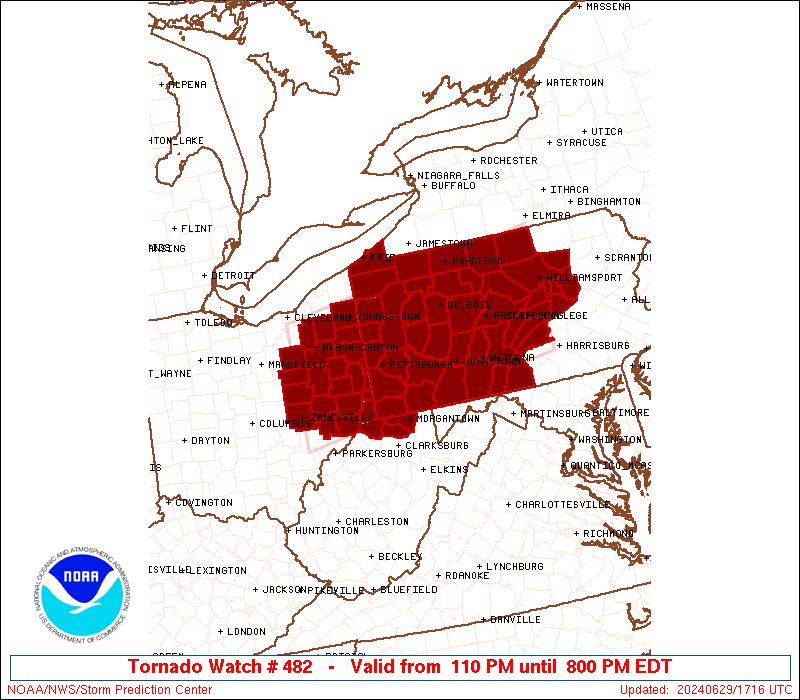
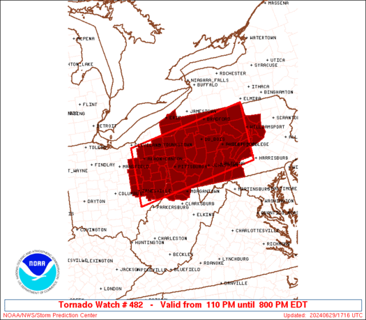
Tornado Watch Number 482
NWS Storm Prediction Center Norman OK
110 PM EDT Sat Jun 29 2024
The NWS Storm Prediction Center has issued a
* Tornado Watch for portions of
Eastern Ohio
Western and Central Pennsylvania
Northern West Virginia
* Effective this Saturday afternoon and evening from 110 PM until
800 PM EDT.
* Primary threats include...
A couple tornadoes possible
Scattered damaging wind gusts to 70 mph likely
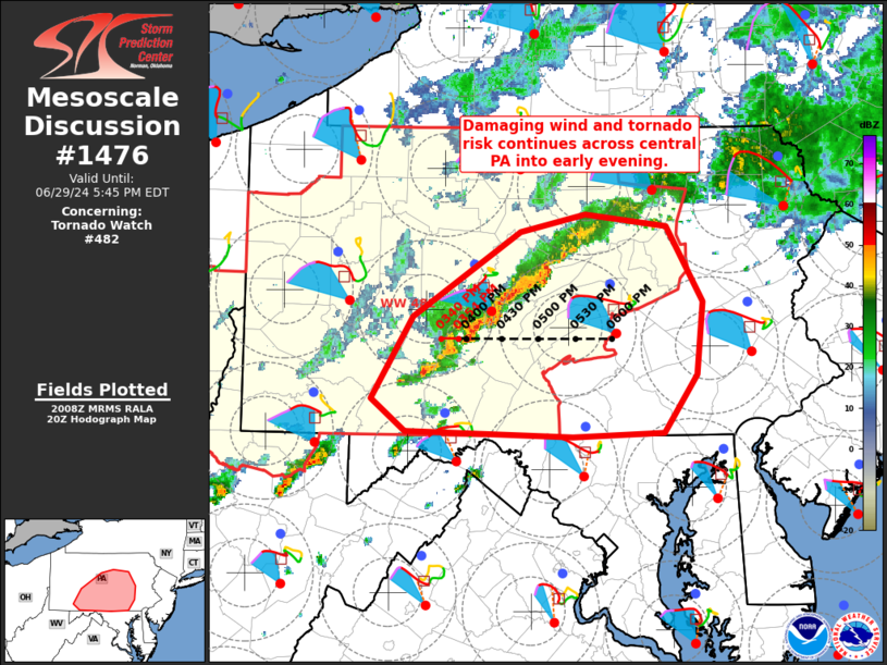
SUMMARY...Thunderstorms should continue to increase in coverage and
intensity this afternoon as they move generally eastward. A couple
of tornadoes appear possible with any supercells that can be
sustained. Otherwise, severe/damaging wind gusts up to 60-70 mph may
occur with any clusters that can develop.
The tornado watch area is approximately along and 65 statute miles
north and south of a line from 30 miles north of Zanesville OH to 50
miles east northeast of State College PA. For a complete depiction
of the watch see the associated watch outline update (WOUS64 KWNS
WOU2).
PRECAUTIONARY/PREPAREDNESS ACTIONS...
REMEMBER...A Tornado Watch means conditions are favorable for
tornadoes and severe thunderstorms in and close to the watch
area. Persons in these areas should be on the lookout for
threatening weather conditions and listen for later statements
and possible warnings.
&&
AVIATION...Tornadoes and a few severe thunderstorms with hail
surface and aloft to 1 inch. Extreme turbulence and surface wind
gusts to 60 knots. A few cumulonimbi with maximum tops to 450. Mean
storm motion vector 27035.
...Gleason
   SEL2

   URGENT - IMMEDIATE BROADCAST REQUESTED
   Tornado Watch Number 482
   NWS Storm Prediction Center Norman OK
   110 PM EDT Sat Jun 29 2024

   The NWS Storm Prediction Center has issued a

   * Tornado Watch for portions of
     Eastern Ohio
     Western and Central Pennsylvania
     Northern West Virginia

   * Effective this Saturday afternoon and evening from 110 PM until
     800 PM EDT.

   * Primary threats include...
     A couple tornadoes possible
     Scattered damaging wind gusts to 70 mph likely

   SUMMARY...Thunderstorms should continue to increase in coverage and
   intensity this afternoon as they move generally eastward. A couple
   of tornadoes appear possible with any supercells that can be
   sustained. Otherwise, severe/damaging wind gusts up to 60-70 mph may
   occur with any clusters that can develop.

   The tornado watch area is approximately along and 65 statute miles
   north and south of a line from 30 miles north of Zanesville OH to 50
   miles east northeast of State College PA. For a complete depiction
   of the watch see the associated watch outline update (WOUS64 KWNS
   WOU2).

   PRECAUTIONARY/PREPAREDNESS ACTIONS...

   REMEMBER...A Tornado Watch means conditions are favorable for
   tornadoes and severe thunderstorms in and close to the watch
   area. Persons in these areas should be on the lookout for
   threatening weather conditions and listen for later statements
   and possible warnings.

   &&

   AVIATION...Tornadoes and a few severe thunderstorms with hail
   surface and aloft to 1 inch. Extreme turbulence and surface wind
   gusts to 60 knots. A few cumulonimbi with maximum tops to 450. Mean
   storm motion vector 27035.

   ...Gleason
 Note:
The Aviation Watch (SAW) product is an approximation to the watch area.
The actual watch is depicted by the shaded areas.
Note:
The Aviation Watch (SAW) product is an approximation to the watch area.
The actual watch is depicted by the shaded areas.
   SAW2
   WW 482 TORNADO OH PA WV 291710Z - 300000Z
   AXIS..65 STATUTE MILES NORTH AND SOUTH OF LINE..
   30N ZZV/ZANESVILLE OH/ - 50ENE UNV/STATE COLLEGE PA/
   ..AVIATION COORDS.. 55NM N/S /35ENE APE - 48ENE PSB/
   HAIL SURFACE AND ALOFT..1 INCH. WIND GUSTS..60 KNOTS.
   MAX TOPS TO 450. MEAN STORM MOTION VECTOR 27035.

   LAT...LON 41328190 42067696 40187696 39438190

   THIS IS AN APPROXIMATION TO THE WATCH AREA.  FOR A
   COMPLETE DEPICTION OF THE WATCH SEE WOUS64 KWNS
   FOR WOU2.
Watch 482 Status Report Messages:
STATUS REPORT #5 ON WW 482

VALID 292245Z - 292340Z

SEVERE WEATHER THREAT CONTINUES RIGHT OF A LINE FROM 15 WSW HGR
TO 30 SE IPT.

..WEINMAN..06/29/24

ATTN...WFO...PBZ...CLE...CTP...

&&

STATUS REPORT FOR WT 482

SEVERE WEATHER THREAT CONTINUES FOR THE FOLLOWING AREAS

PAC001-041-043-071-075-099-107-133-292340-

PA
.    PENNSYLVANIA COUNTIES INCLUDED ARE

ADAMS		     CUMBERLAND 	 DAUPHIN
LANCASTER	     LEBANON		 PERRY
SCHUYLKILL	     YORK
$$


THE WATCH STATUS MESSAGE IS FOR GUIDANCE PURPOSES ONLY.  PLEASE
REFER TO WATCH COUNTY NOTIFICATION STATEMENTS FOR OFFICIAL
INFORMATION ON COUNTIES...INDEPENDENT CITIES AND MARINE ZONES
CLEARED FROM SEVERE THUNDERSTORM AND TORNADO WATCHES.
$$

STATUS REPORT #4 ON WW 482

VALID 292150Z - 292240Z

SEVERE WEATHER THREAT CONTINUES RIGHT OF A LINE FROM 20 NW ZZV TO
20 ENE IPT.

..WEINMAN..06/29/24

ATTN...WFO...PBZ...CLE...CTP...

&&

STATUS REPORT FOR WT 482

SEVERE WEATHER THREAT CONTINUES FOR THE FOLLOWING AREAS

OHC013-059-067-081-111-119-121-292240-

OH
.    OHIO COUNTIES INCLUDED ARE

BELMONT 	     GUERNSEY		 HARRISON
JEFFERSON	     MONROE		 MUSKINGUM
NOBLE
$$


PAC001-003-037-041-043-051-055-057-059-061-063-067-071-075-087-
093-097-099-107-109-119-125-129-133-292240-

PA
.    PENNSYLVANIA COUNTIES INCLUDED ARE

ADAMS		     ALLEGHENY		 COLUMBIA
CUMBERLAND	     DAUPHIN		 FAYETTE
FRANKLIN	     FULTON		 GREENE
HUNTINGDON	     INDIANA		 JUNIATA
LANCASTER	     LEBANON		 MIFFLIN
MONTOUR 	     NORTHUMBERLAND	 PERRY
SCHUYLKILL	     SNYDER		 UNION
WASHINGTON	     WESTMORELAND	 YORK
$$


WVC009-029-049-051-061-069-103-292240-

WV
.    WEST VIRGINIA COUNTIES INCLUDED ARE

BROOKE		     HANCOCK		 MARION
MARSHALL	     MONONGALIA 	 OHIO
WETZEL
$$


THE WATCH STATUS MESSAGE IS FOR GUIDANCE PURPOSES ONLY.  PLEASE
REFER TO WATCH COUNTY NOTIFICATION STATEMENTS FOR OFFICIAL
INFORMATION ON COUNTIES...INDEPENDENT CITIES AND MARINE ZONES
CLEARED FROM SEVERE THUNDERSTORM AND TORNADO WATCHES.
$$

STATUS REPORT #3 ON WW 482

VALID 292030Z - 292140Z

SEVERE WEATHER THREAT CONTINUES RIGHT OF A LINE FROM 30 NW ZZV TO
20 SW DUJ TO 30 SSE ELM.

..LEITMAN..06/29/24

ATTN...WFO...PBZ...CLE...CTP...

&&

STATUS REPORT FOR WT 482

SEVERE WEATHER THREAT CONTINUES FOR THE FOLLOWING AREAS

OHC013-019-031-059-067-081-111-119-121-157-292140-

OH
.    OHIO COUNTIES INCLUDED ARE

BELMONT 	     CARROLL		 COSHOCTON
GUERNSEY	     HARRISON		 JEFFERSON
MONROE		     MUSKINGUM		 NOBLE
TUSCARAWAS
$$


PAC003-005-007-009-013-021-027-033-035-037-051-055-057-059-061-
063-067-081-087-093-097-099-109-111-113-119-125-129-292140-

PA
.    PENNSYLVANIA COUNTIES INCLUDED ARE

ALLEGHENY	     ARMSTRONG		 BEAVER
BEDFORD 	     BLAIR		 CAMBRIA
CENTRE		     CLEARFIELD 	 CLINTON
COLUMBIA	     FAYETTE		 FRANKLIN
FULTON		     GREENE		 HUNTINGDON
INDIANA 	     JUNIATA		 LYCOMING
MIFFLIN 	     MONTOUR		 NORTHUMBERLAND
PERRY		     SNYDER		 SOMERSET
SULLIVAN	     UNION		 WASHINGTON
WESTMORELAND
$$


WVC009-029-049-051-061-069-103-292140-

WV
.    WEST VIRGINIA COUNTIES INCLUDED ARE

BROOKE		     HANCOCK		 MARION
MARSHALL	     MONONGALIA 	 OHIO
WETZEL
$$


THE WATCH STATUS MESSAGE IS FOR GUIDANCE PURPOSES ONLY.  PLEASE
REFER TO WATCH COUNTY NOTIFICATION STATEMENTS FOR OFFICIAL
INFORMATION ON COUNTIES...INDEPENDENT CITIES AND MARINE ZONES
CLEARED FROM SEVERE THUNDERSTORM AND TORNADO WATCHES.
$$

STATUS REPORT #2 ON WW 482

VALID 291955Z - 292040Z

SEVERE WEATHER THREAT CONTINUES RIGHT OF A LINE FROM 30 SSE MFD
TO 30 SE FKL TO 20 S BFD TO 30 ENE BFD.

..LEITMAN..06/29/24

ATTN...WFO...PBZ...CLE...CTP...

&&

STATUS REPORT FOR WT 482

SEVERE WEATHER THREAT CONTINUES FOR THE FOLLOWING AREAS

OHC013-019-031-059-067-081-111-119-121-157-292040-

OH
.    OHIO COUNTIES INCLUDED ARE

BELMONT 	     CARROLL		 COSHOCTON
GUERNSEY	     HARRISON		 JEFFERSON
MONROE		     MUSKINGUM		 NOBLE
TUSCARAWAS
$$


PAC003-005-007-009-013-019-021-023-027-031-033-035-037-047-051-
055-057-059-061-063-065-067-081-087-093-097-099-105-109-111-113-
117-119-125-129-292040-

PA
.    PENNSYLVANIA COUNTIES INCLUDED ARE

ALLEGHENY	     ARMSTRONG		 BEAVER
BEDFORD 	     BLAIR		 BUTLER
CAMBRIA 	     CAMERON		 CENTRE
CLARION 	     CLEARFIELD 	 CLINTON
COLUMBIA	     ELK		 FAYETTE
FRANKLIN	     FULTON		 GREENE
HUNTINGDON	     INDIANA		 JEFFERSON
JUNIATA 	     LYCOMING		 MIFFLIN
MONTOUR 	     NORTHUMBERLAND	 PERRY
POTTER		     SNYDER		 SOMERSET
SULLIVAN	     TIOGA		 UNION
WASHINGTON	     WESTMORELAND
$$


WVC009-029-049-051-061-069-103-292040-

WV
.    WEST VIRGINIA COUNTIES INCLUDED ARE

BROOKE		     HANCOCK		 MARION
MARSHALL	     MONONGALIA 	 OHIO
WETZEL
$$


THE WATCH STATUS MESSAGE IS FOR GUIDANCE PURPOSES ONLY.  PLEASE
REFER TO WATCH COUNTY NOTIFICATION STATEMENTS FOR OFFICIAL
INFORMATION ON COUNTIES...INDEPENDENT CITIES AND MARINE ZONES
CLEARED FROM SEVERE THUNDERSTORM AND TORNADO WATCHES.
$$

STATUS REPORT #1 ON WW 482

VALID 291840Z - 291940Z

SEVERE WEATHER THREAT CONTINUES RIGHT OF A LINE FROM 20 E MFD TO
10 E YNG TO 25 SSW JHW.

..EDWARDS..06/29/24

ATTN...WFO...PBZ...CLE...CTP...

&&

STATUS REPORT FOR WT 482

SEVERE WEATHER THREAT CONTINUES FOR THE FOLLOWING AREAS

OHC013-019-029-031-059-067-075-081-099-111-119-121-151-157-169-
291940-

OH
.    OHIO COUNTIES INCLUDED ARE

BELMONT 	     CARROLL		 COLUMBIANA
COSHOCTON	     GUERNSEY		 HARRISON
HOLMES		     JEFFERSON		 MAHONING
MONROE		     MUSKINGUM		 NOBLE
STARK		     TUSCARAWAS 	 WAYNE
$$


PAC003-005-007-009-013-019-021-023-027-031-033-035-037-047-051-
053-055-057-059-061-063-065-067-073-081-083-085-087-093-097-099-
105-109-111-113-117-119-121-123-125-129-291940-

PA
.    PENNSYLVANIA COUNTIES INCLUDED ARE

ALLEGHENY	     ARMSTRONG		 BEAVER
BEDFORD 	     BLAIR		 BUTLER
CAMBRIA 	     CAMERON		 CENTRE
CLARION 	     CLEARFIELD 	 CLINTON
COLUMBIA	     ELK		 FAYETTE
FOREST		     FRANKLIN		 FULTON
GREENE		     HUNTINGDON 	 INDIANA
JEFFERSON	     JUNIATA		 LAWRENCE
LYCOMING	     MCKEAN		 MERCER
MIFFLIN 	     MONTOUR		 NORTHUMBERLAND
PERRY		     POTTER		 SNYDER
SOMERSET	     SULLIVAN		 TIOGA
UNION		     VENANGO		 WARREN
WASHINGTON	     WESTMORELAND
$$


WVC009-029-049-051-061-069-103-291940-

WV
.    WEST VIRGINIA COUNTIES INCLUDED ARE

BROOKE		     HANCOCK		 MARION
MARSHALL	     MONONGALIA 	 OHIO
WETZEL
$$


THE WATCH STATUS MESSAGE IS FOR GUIDANCE PURPOSES ONLY.  PLEASE
REFER TO WATCH COUNTY NOTIFICATION STATEMENTS FOR OFFICIAL
INFORMATION ON COUNTIES...INDEPENDENT CITIES AND MARINE ZONES
CLEARED FROM SEVERE THUNDERSTORM AND TORNADO WATCHES.
$$
Note:
Click for Complete Product Text.
Tornadoes
Probability of 2 or more tornadoes
|
Mod (40%)
|
Probability of 1 or more strong (EF2-EF5) tornadoes
|
Low (20%)
|
Wind
Probability of 10 or more severe wind events
|
High (70%)
|
Probability of 1 or more wind events > 65 knots
|
Low (20%)
|
Hail
Probability of 10 or more severe hail events
|
Low (10%)
|
Probability of 1 or more hailstones > 2 inches
|
Low (<5%)
|
Combined Severe Hail/Wind
Probability of 6 or more combined severe hail/wind events
|
High (80%)
|
For each watch, probabilities for particular events inside the watch
(listed above in each table) are determined by the issuing forecaster.
The "Low" category contains probability values ranging from less than 2%
to 20% (EF2-EF5 tornadoes), less than 5% to 20% (all other probabilities),
"Moderate" from 30% to 60%, and "High" from 70% to greater than 95%.
High values are bolded and lighter in color to provide awareness of
an increased threat for a particular event.


 @NWSSPC