Note:
The expiration time in the watch graphic is amended if the watch is
replaced, cancelled or extended.
Note:
Note:
The expiration time in the watch graphic is amended if the watch is
replaced, cancelled or extended.
Note: Click for
Watch Status Reports.
SEL9
URGENT - IMMEDIATE BROADCAST REQUESTED
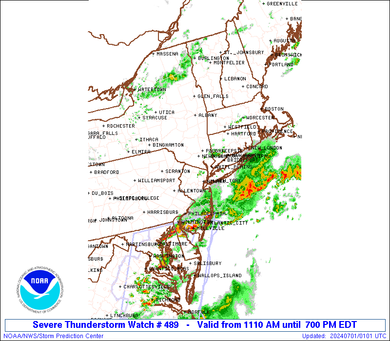
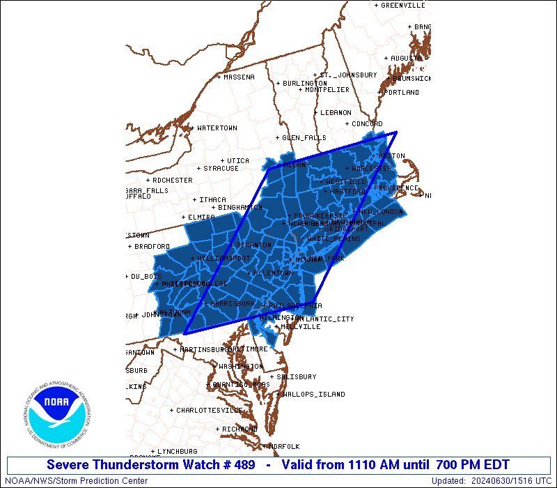
Severe Thunderstorm Watch Number 489
NWS Storm Prediction Center Norman OK
1110 AM EDT Sun Jun 30 2024
The NWS Storm Prediction Center has issued a
* Severe Thunderstorm Watch for portions of
Connecticut
Northern Delaware
Massachusetts
New Jersey
Southern New York
Central and Eastern Pennsylvania
Rhode Island
Coastal Waters
* Effective this Sunday morning and evening from 1110 AM until
700 PM EDT.
* Primary threats include...
Widespread damaging winds likely with isolated significant gusts
to 75 mph possible
Isolated large hail events to 1.5 inches in diameter possible
SUMMARY...A mix of thunderstorm clusters and supercells should pose
a threat for numerous to widespread severe/damaging winds as they
move eastward this afternoon and evening. Peak wind gusts should
generally range around 60-70 mph, with isolated gusts perhaps
reaching up to 75 mph. Occasional hail around 1-1.5 inches in
diameter may also occur with any sustained supercell.
The severe thunderstorm watch area is approximately along and 100
statute miles east and west of a line from 35 miles north northwest
of Worcester MA to 30 miles west southwest of Philadelphia PA. For a
complete depiction of the watch see the associated watch outline
update (WOUS64 KWNS WOU9).
PRECAUTIONARY/PREPAREDNESS ACTIONS...
REMEMBER...A Severe Thunderstorm Watch means conditions are
favorable for severe thunderstorms in and close to the watch area.
Persons in these areas should be on the lookout for threatening
weather conditions and listen for later statements and possible
warnings. Severe thunderstorms can and occasionally do produce
tornadoes.
&&
AVIATION...A few severe thunderstorms with hail surface and aloft to
1.5 inches. Extreme turbulence and surface wind gusts to 65 knots. A
few cumulonimbi with maximum tops to 500. Mean storm motion vector
27035.
...Gleason

   SEL9

   URGENT - IMMEDIATE BROADCAST REQUESTED
   Severe Thunderstorm Watch Number 489
   NWS Storm Prediction Center Norman OK
   1110 AM EDT Sun Jun 30 2024

   The NWS Storm Prediction Center has issued a

   * Severe Thunderstorm Watch for portions of
     Connecticut
     Northern Delaware
     Massachusetts
     New Jersey
     Southern New York
     Central and Eastern Pennsylvania
     Rhode Island
     Coastal Waters

   * Effective this Sunday morning and evening from 1110 AM until
     700 PM EDT.

   * Primary threats include...
     Widespread damaging winds likely with isolated significant gusts
       to 75 mph possible
     Isolated large hail events to 1.5 inches in diameter possible

   SUMMARY...A mix of thunderstorm clusters and supercells should pose
   a threat for numerous to widespread severe/damaging winds as they
   move eastward this afternoon and evening. Peak wind gusts should
   generally range around 60-70 mph, with isolated gusts perhaps
   reaching up to 75 mph. Occasional hail around 1-1.5 inches in
   diameter may also occur with any sustained supercell.

   The severe thunderstorm watch area is approximately along and 100
   statute miles east and west of a line from 35 miles north northwest
   of Worcester MA to 30 miles west southwest of Philadelphia PA. For a
   complete depiction of the watch see the associated watch outline
   update (WOUS64 KWNS WOU9).

   PRECAUTIONARY/PREPAREDNESS ACTIONS...

   REMEMBER...A Severe Thunderstorm Watch means conditions are
   favorable for severe thunderstorms in and close to the watch area.
   Persons in these areas should be on the lookout for threatening
   weather conditions and listen for later statements and possible
   warnings. Severe thunderstorms can and occasionally do produce
   tornadoes.

   &&

   AVIATION...A few severe thunderstorms with hail surface and aloft to
   1.5 inches. Extreme turbulence and surface wind gusts to 65 knots. A
   few cumulonimbi with maximum tops to 500. Mean storm motion vector
   27035.

   ...Gleason
 Note:
The Aviation Watch (SAW) product is an approximation to the watch area.
The actual watch is depicted by the shaded areas.
Note:
The Aviation Watch (SAW) product is an approximation to the watch area.
The actual watch is depicted by the shaded areas.
   SAW9
   WW 489 SEVERE TSTM CT DE MA NJ NY PA RI CW 301510Z - 302300Z
   AXIS..100 STATUTE MILES EAST AND WEST OF LINE..
   35NNW ORH/WORCESTER MA/ - 30WSW PHL/PHILADELPHIA PA/
   ..AVIATION COORDS.. 85NM E/W /38SW CON - 53S ETX/
   HAIL SURFACE AND ALOFT..1.5 INCHES. WIND GUSTS..65 KNOTS.
   MAX TOPS TO 500. MEAN STORM MOTION VECTOR 27035.

   LAT...LON 42727017 39687389 39687765 42727411

   THIS IS AN APPROXIMATION TO THE WATCH AREA.  FOR A
   COMPLETE DEPICTION OF THE WATCH SEE WOUS64 KWNS
   FOR WOU9.
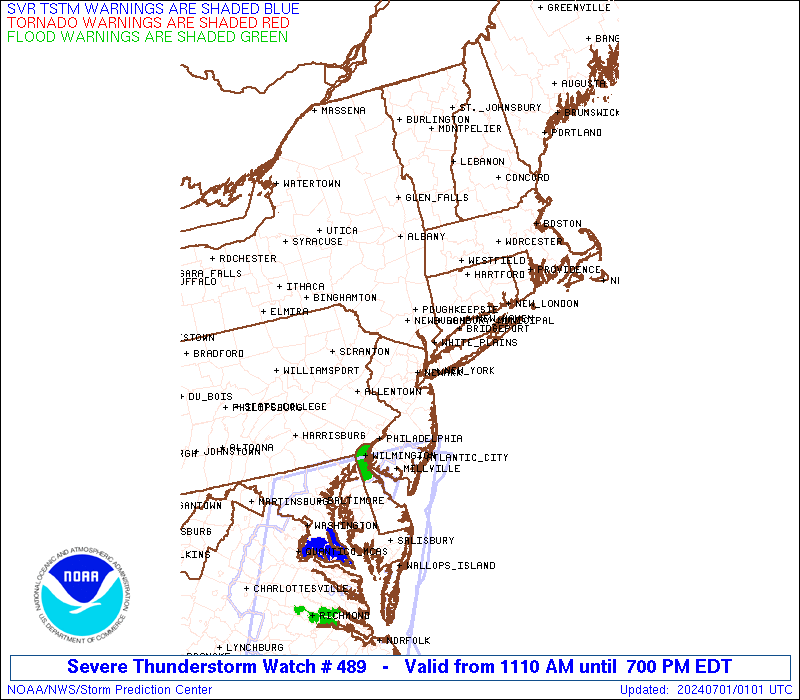
Watch 489 Status Report Messages:
STATUS REPORT #6 ON WW 489
VALID 302145Z - 302240Z
SEVERE WEATHER THREAT CONTINUES RIGHT OF A LINE FROM 10 SSW HGR
TO 25 SSE AVP TO 20 E MSV TO 10 S CON.
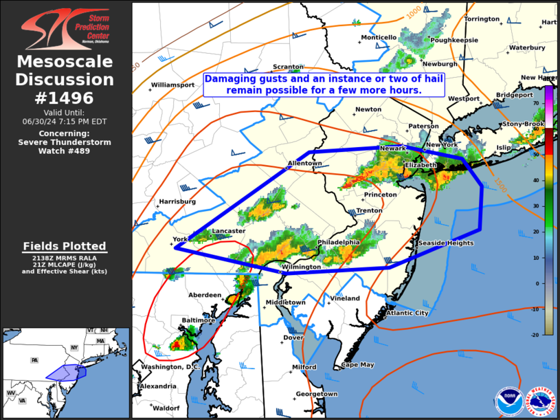
FOR ADDITIONAL INFORMATION SEE MESOSCALE DISCUSSION 1496
..WEINMAN..06/30/24
ATTN...WFO...OKX...BOX...ALY...PHI...BGM...CTP...
&&
STATUS REPORT FOR WS 489
SEVERE WEATHER THREAT CONTINUES FOR THE FOLLOWING AREAS
CTC001-003-005-007-009-011-013-015-302240-
CT
. CONNECTICUT COUNTIES INCLUDED ARE
FAIRFIELD HARTFORD LITCHFIELD
MIDDLESEX NEW HAVEN NEW LONDON
TOLLAND WINDHAM
$$
DEC003-302240-
DE
. DELAWARE COUNTIES INCLUDED ARE
NEW CASTLE
$$
MAC003-005-009-011-013-015-017-021-023-025-027-302240-
MA
. MASSACHUSETTS COUNTIES INCLUDED ARE
BERKSHIRE BRISTOL ESSEX
FRANKLIN HAMPDEN HAMPSHIRE
MIDDLESEX NORFOLK PLYMOUTH
SUFFOLK WORCESTER
$$
NJC003-005-007-013-015-017-019-021-023-025-027-029-031-033-035-
037-039-041-302240-
NJ
. NEW JERSEY COUNTIES INCLUDED ARE
BERGEN BURLINGTON CAMDEN
ESSEX GLOUCESTER HUDSON
HUNTERDON MERCER MIDDLESEX
MONMOUTH MORRIS OCEAN
PASSAIC SALEM SOMERSET
SUSSEX UNION WARREN
$$
NYC005-021-027-047-059-061-071-079-081-085-087-103-111-119-
302240-
NY
. NEW YORK COUNTIES INCLUDED ARE
BRONX COLUMBIA DUTCHESS
KINGS NASSAU NEW YORK (MANHATTAN)
ORANGE PUTNAM QUEENS
RICHMOND ROCKLAND SUFFOLK
ULSTER WESTCHESTER
$$
PAC001-011-017-025-029-045-071-077-089-091-095-101-133-302240-
PA
. PENNSYLVANIA COUNTIES INCLUDED ARE
ADAMS BERKS BUCKS
CARBON CHESTER DELAWARE
LANCASTER LEHIGH MONROE
MONTGOMERY NORTHAMPTON PHILADELPHIA
YORK
$$
RIC001-003-005-007-009-302240-
RI
. RHODE ISLAND COUNTIES INCLUDED ARE
BRISTOL KENT NEWPORT
PROVIDENCE WASHINGTON
$$
ANZ230-234-235-236-237-251-256-331-332-335-338-340-345-350-353-
355-430-450-451-302240-
CW
. ADJACENT COASTAL WATERS INCLUDED ARE
BOSTON HARBOR
BUZZARDS BAY
RHODE ISLAND SOUND
NARRAGANSETT BAY
BLOCK ISLAND SOUND
MASSACHUSETTS BAY AND IPSWICH BAY
COASTAL WATERS FROM MONTAUK NY TO MARTHAS VINEYARD EXTENDING OUT
TO 20 NM SOUTH OF BLOCK ISLAND
LONG ISLAND SOUND EAST OF NEW HAVEN CT/PORT JEFFERSON NY TO THE
MOUTH OF THE CONNECTICUT RIVER
LONG ISLAND SOUND EAST OF THE MOUTH OF THE CONNECTICUT RIVER
LONG ISLAND SOUND WEST OF NEW HAVEN CT/PORT JEFFERSON NY
NEW YORK HARBOR
PECONIC AND GARDINERS BAYS
SOUTH SHORE BAYS FROM JONES INLET THROUGH SHINNECOCK BAY
MORICHES INLET NY TO MONTAUK POINT NY OUT 20 NM
FIRE ISLAND INLET NY TO MORICHES INLET NY OUT 20 NM
SANDY HOOK NJ TO FIRE ISLAND INLET NY OUT 20 NM
DELAWARE BAY WATERS NORTH OF EAST POINT NJ TO SLAUGHTER BEACH DE
COASTAL WATERS FROM SANDY HOOK TO MANASQUAN INLET NJ OUT 20 NM
COASTAL WATERS FROM MANASQUAN INLET TO LITTLE EGG INLET NJ OUT 20
NM
$$
THE WATCH STATUS MESSAGE IS FOR GUIDANCE PURPOSES ONLY. PLEASE
REFER TO WATCH COUNTY NOTIFICATION STATEMENTS FOR OFFICIAL
INFORMATION ON COUNTIES...INDEPENDENT CITIES AND MARINE ZONES
CLEARED FROM SEVERE THUNDERSTORM AND TORNADO WATCHES.
$$
STATUS REPORT #5 ON WW 489
VALID 302020Z - 302140Z
SEVERE WEATHER THREAT CONTINUES RIGHT OF A LINE FROM 5 S HGR TO
25 SSE AVP TO 10 NNE MSV TO 25 W EEN.
..LEITMAN..06/30/24
ATTN...WFO...OKX...BOX...ALY...PHI...BGM...CTP...
&&
STATUS REPORT FOR WS 489
SEVERE WEATHER THREAT CONTINUES FOR THE FOLLOWING AREAS
CTC001-003-005-007-009-011-013-015-302140-
CT
. CONNECTICUT COUNTIES INCLUDED ARE
FAIRFIELD HARTFORD LITCHFIELD
MIDDLESEX NEW HAVEN NEW LONDON
TOLLAND WINDHAM
$$
DEC003-302140-
DE
. DELAWARE COUNTIES INCLUDED ARE
NEW CASTLE
$$
MAC003-005-009-011-013-015-017-021-023-025-027-302140-
MA
. MASSACHUSETTS COUNTIES INCLUDED ARE
BERKSHIRE BRISTOL ESSEX
FRANKLIN HAMPDEN HAMPSHIRE
MIDDLESEX NORFOLK PLYMOUTH
SUFFOLK WORCESTER
$$
NJC003-005-007-013-015-017-019-021-023-025-027-029-031-033-035-
037-039-041-302140-
NJ
. NEW JERSEY COUNTIES INCLUDED ARE
BERGEN BURLINGTON CAMDEN
ESSEX GLOUCESTER HUDSON
HUNTERDON MERCER MIDDLESEX
MONMOUTH MORRIS OCEAN
PASSAIC SALEM SOMERSET
SUSSEX UNION WARREN
$$
NYC005-021-027-047-059-061-071-079-081-085-087-103-105-111-119-
302140-
NY
. NEW YORK COUNTIES INCLUDED ARE
BRONX COLUMBIA DUTCHESS
KINGS NASSAU NEW YORK (MANHATTAN)
ORANGE PUTNAM QUEENS
RICHMOND ROCKLAND SUFFOLK
SULLIVAN ULSTER WESTCHESTER
$$
PAC001-011-017-025-029-045-071-077-089-091-095-101-103-133-
302140-
PA
. PENNSYLVANIA COUNTIES INCLUDED ARE
ADAMS BERKS BUCKS
CARBON CHESTER DELAWARE
LANCASTER LEHIGH MONROE
MONTGOMERY NORTHAMPTON PHILADELPHIA
PIKE YORK
$$
RIC001-003-005-007-009-302140-
RI
. RHODE ISLAND COUNTIES INCLUDED ARE
BRISTOL KENT NEWPORT
PROVIDENCE WASHINGTON
$$
ANZ230-234-235-236-237-251-256-331-332-335-338-340-345-350-353-
355-430-450-451-302140-
CW
. ADJACENT COASTAL WATERS INCLUDED ARE
BOSTON HARBOR
BUZZARDS BAY
RHODE ISLAND SOUND
NARRAGANSETT BAY
BLOCK ISLAND SOUND
MASSACHUSETTS BAY AND IPSWICH BAY
COASTAL WATERS FROM MONTAUK NY TO MARTHAS VINEYARD EXTENDING OUT
TO 20 NM SOUTH OF BLOCK ISLAND
LONG ISLAND SOUND EAST OF NEW HAVEN CT/PORT JEFFERSON NY TO THE
MOUTH OF THE CONNECTICUT RIVER
LONG ISLAND SOUND EAST OF THE MOUTH OF THE CONNECTICUT RIVER
LONG ISLAND SOUND WEST OF NEW HAVEN CT/PORT JEFFERSON NY
NEW YORK HARBOR
PECONIC AND GARDINERS BAYS
SOUTH SHORE BAYS FROM JONES INLET THROUGH SHINNECOCK BAY
MORICHES INLET NY TO MONTAUK POINT NY OUT 20 NM
FIRE ISLAND INLET NY TO MORICHES INLET NY OUT 20 NM
SANDY HOOK NJ TO FIRE ISLAND INLET NY OUT 20 NM
DELAWARE BAY WATERS NORTH OF EAST POINT NJ TO SLAUGHTER BEACH DE
COASTAL WATERS FROM SANDY HOOK TO MANASQUAN INLET NJ OUT 20 NM
COASTAL WATERS FROM MANASQUAN INLET TO LITTLE EGG INLET NJ OUT 20
NM
$$
THE WATCH STATUS MESSAGE IS FOR GUIDANCE PURPOSES ONLY. PLEASE
REFER TO WATCH COUNTY NOTIFICATION STATEMENTS FOR OFFICIAL
INFORMATION ON COUNTIES...INDEPENDENT CITIES AND MARINE ZONES
CLEARED FROM SEVERE THUNDERSTORM AND TORNADO WATCHES.
$$
STATUS REPORT #4 ON WW 489
VALID 301935Z - 302040Z
SEVERE WEATHER THREAT CONTINUES RIGHT OF A LINE FROM 25 W HGR TO
30 NW CXY TO 30 WNW MSV TO 40 NNE PSF.
..LEITMAN..06/30/24
ATTN...WFO...OKX...BOX...ALY...PHI...BGM...CTP...
&&
STATUS REPORT FOR WS 489
SEVERE WEATHER THREAT CONTINUES FOR THE FOLLOWING AREAS
CTC001-003-005-007-009-011-013-015-302040-
CT
. CONNECTICUT COUNTIES INCLUDED ARE
FAIRFIELD HARTFORD LITCHFIELD
MIDDLESEX NEW HAVEN NEW LONDON
TOLLAND WINDHAM
$$
DEC003-302040-
DE
. DELAWARE COUNTIES INCLUDED ARE
NEW CASTLE
$$
MAC003-005-009-011-013-015-017-021-023-025-027-302040-
MA
. MASSACHUSETTS COUNTIES INCLUDED ARE
BERKSHIRE BRISTOL ESSEX
FRANKLIN HAMPDEN HAMPSHIRE
MIDDLESEX NORFOLK PLYMOUTH
SUFFOLK WORCESTER
$$
NJC003-005-007-013-015-017-019-021-023-025-027-029-031-033-035-
037-039-041-302040-
NJ
. NEW JERSEY COUNTIES INCLUDED ARE
BERGEN BURLINGTON CAMDEN
ESSEX GLOUCESTER HUDSON
HUNTERDON MERCER MIDDLESEX
MONMOUTH MORRIS OCEAN
PASSAIC SALEM SOMERSET
SUSSEX UNION WARREN
$$
NYC005-021-027-039-047-059-061-071-079-081-083-085-087-103-105-
111-119-302040-
NY
. NEW YORK COUNTIES INCLUDED ARE
BRONX COLUMBIA DUTCHESS
GREENE KINGS NASSAU
NEW YORK (MANHATTAN) ORANGE PUTNAM
QUEENS RENSSELAER RICHMOND
ROCKLAND SUFFOLK SULLIVAN
ULSTER WESTCHESTER
$$
PAC001-011-017-025-029-041-043-045-055-069-071-075-077-079-089-
091-095-099-101-103-107-127-133-302040-
PA
. PENNSYLVANIA COUNTIES INCLUDED ARE
ADAMS BERKS BUCKS
CARBON CHESTER CUMBERLAND
DAUPHIN DELAWARE FRANKLIN
LACKAWANNA LANCASTER LEBANON
LEHIGH LUZERNE MONROE
MONTGOMERY NORTHAMPTON PERRY
PHILADELPHIA PIKE SCHUYLKILL
WAYNE YORK
$$
RIC001-003-005-007-009-302040-
RI
. RHODE ISLAND COUNTIES INCLUDED ARE
BRISTOL KENT NEWPORT
PROVIDENCE WASHINGTON
$$
ANZ230-234-235-236-237-251-256-331-332-335-338-340-345-350-353-
355-430-450-451-302040-
CW
. ADJACENT COASTAL WATERS INCLUDED ARE
BOSTON HARBOR
BUZZARDS BAY
RHODE ISLAND SOUND
NARRAGANSETT BAY
BLOCK ISLAND SOUND
MASSACHUSETTS BAY AND IPSWICH BAY
COASTAL WATERS FROM MONTAUK NY TO MARTHAS VINEYARD EXTENDING OUT
TO 20 NM SOUTH OF BLOCK ISLAND
LONG ISLAND SOUND EAST OF NEW HAVEN CT/PORT JEFFERSON NY TO THE
MOUTH OF THE CONNECTICUT RIVER
LONG ISLAND SOUND EAST OF THE MOUTH OF THE CONNECTICUT RIVER
LONG ISLAND SOUND WEST OF NEW HAVEN CT/PORT JEFFERSON NY
NEW YORK HARBOR
PECONIC AND GARDINERS BAYS
SOUTH SHORE BAYS FROM JONES INLET THROUGH SHINNECOCK BAY
MORICHES INLET NY TO MONTAUK POINT NY OUT 20 NM
FIRE ISLAND INLET NY TO MORICHES INLET NY OUT 20 NM
SANDY HOOK NJ TO FIRE ISLAND INLET NY OUT 20 NM
DELAWARE BAY WATERS NORTH OF EAST POINT NJ TO SLAUGHTER BEACH DE
COASTAL WATERS FROM SANDY HOOK TO MANASQUAN INLET NJ OUT 20 NM
COASTAL WATERS FROM MANASQUAN INLET TO LITTLE EGG INLET NJ OUT 20
NM
$$
THE WATCH STATUS MESSAGE IS FOR GUIDANCE PURPOSES ONLY. PLEASE
REFER TO WATCH COUNTY NOTIFICATION STATEMENTS FOR OFFICIAL
INFORMATION ON COUNTIES...INDEPENDENT CITIES AND MARINE ZONES
CLEARED FROM SEVERE THUNDERSTORM AND TORNADO WATCHES.
$$
STATUS REPORT #3 ON WW 489
VALID 301835Z - 301940Z
SEVERE WEATHER THREAT CONTINUES RIGHT OF A LINE FROM 25 NNE AOO
TO 15 NNW AVP TO 10 N ALB.
..LEITMAN..06/30/24
ATTN...WFO...OKX...BOX...ALY...PHI...BGM...CTP...
&&
STATUS REPORT FOR WS 489
SEVERE WEATHER THREAT CONTINUES FOR THE FOLLOWING AREAS
CTC001-003-005-007-009-011-013-015-301940-
CT
. CONNECTICUT COUNTIES INCLUDED ARE
FAIRFIELD HARTFORD LITCHFIELD
MIDDLESEX NEW HAVEN NEW LONDON
TOLLAND WINDHAM
$$
DEC003-301940-
DE
. DELAWARE COUNTIES INCLUDED ARE
NEW CASTLE
$$
MAC003-005-009-011-013-015-017-021-023-025-027-301940-
MA
. MASSACHUSETTS COUNTIES INCLUDED ARE
BERKSHIRE BRISTOL ESSEX
FRANKLIN HAMPDEN HAMPSHIRE
MIDDLESEX NORFOLK PLYMOUTH
SUFFOLK WORCESTER
$$
NJC003-005-007-013-015-017-019-021-023-025-027-029-031-033-035-
037-039-041-301940-
NJ
. NEW JERSEY COUNTIES INCLUDED ARE
BERGEN BURLINGTON CAMDEN
ESSEX GLOUCESTER HUDSON
HUNTERDON MERCER MIDDLESEX
MONMOUTH MORRIS OCEAN
PASSAIC SALEM SOMERSET
SUSSEX UNION WARREN
$$
NYC001-005-021-027-039-047-059-061-071-079-081-083-085-087-103-
105-111-119-301940-
NY
. NEW YORK COUNTIES INCLUDED ARE
ALBANY BRONX COLUMBIA
DUTCHESS GREENE KINGS
NASSAU NEW YORK (MANHATTAN)ORANGE
PUTNAM QUEENS RENSSELAER
RICHMOND ROCKLAND SUFFOLK
SULLIVAN ULSTER WESTCHESTER
$$
PAC001-011-017-025-029-037-041-043-045-055-057-061-067-069-071-
075-077-079-087-089-091-093-095-097-099-101-103-107-109-119-127-
133-301940-
PA
. PENNSYLVANIA COUNTIES INCLUDED ARE
ADAMS BERKS BUCKS
CARBON CHESTER COLUMBIA
CUMBERLAND DAUPHIN DELAWARE
FRANKLIN FULTON HUNTINGDON
JUNIATA LACKAWANNA LANCASTER
LEBANON LEHIGH LUZERNE
MIFFLIN MONROE MONTGOMERY
MONTOUR NORTHAMPTON NORTHUMBERLAND
PERRY PHILADELPHIA PIKE
SCHUYLKILL SNYDER UNION
WAYNE YORK
$$
RIC001-003-005-007-009-301940-
RI
. RHODE ISLAND COUNTIES INCLUDED ARE
BRISTOL KENT NEWPORT
PROVIDENCE WASHINGTON
$$
ANZ230-234-235-236-237-251-256-331-332-335-338-340-345-350-353-
355-430-450-451-301940-
CW
. ADJACENT COASTAL WATERS INCLUDED ARE
BOSTON HARBOR
BUZZARDS BAY
RHODE ISLAND SOUND
NARRAGANSETT BAY
BLOCK ISLAND SOUND
MASSACHUSETTS BAY AND IPSWICH BAY
COASTAL WATERS FROM MONTAUK NY TO MARTHAS VINEYARD EXTENDING OUT
TO 20 NM SOUTH OF BLOCK ISLAND
LONG ISLAND SOUND EAST OF NEW HAVEN CT/PORT JEFFERSON NY TO THE
MOUTH OF THE CONNECTICUT RIVER
LONG ISLAND SOUND EAST OF THE MOUTH OF THE CONNECTICUT RIVER
LONG ISLAND SOUND WEST OF NEW HAVEN CT/PORT JEFFERSON NY
NEW YORK HARBOR
PECONIC AND GARDINERS BAYS
SOUTH SHORE BAYS FROM JONES INLET THROUGH SHINNECOCK BAY
MORICHES INLET NY TO MONTAUK POINT NY OUT 20 NM
FIRE ISLAND INLET NY TO MORICHES INLET NY OUT 20 NM
SANDY HOOK NJ TO FIRE ISLAND INLET NY OUT 20 NM
DELAWARE BAY WATERS NORTH OF EAST POINT NJ TO SLAUGHTER BEACH DE
COASTAL WATERS FROM SANDY HOOK TO MANASQUAN INLET NJ OUT 20 NM
COASTAL WATERS FROM MANASQUAN INLET TO LITTLE EGG INLET NJ OUT 20
NM
$$
THE WATCH STATUS MESSAGE IS FOR GUIDANCE PURPOSES ONLY. PLEASE
REFER TO WATCH COUNTY NOTIFICATION STATEMENTS FOR OFFICIAL
INFORMATION ON COUNTIES...INDEPENDENT CITIES AND MARINE ZONES
CLEARED FROM SEVERE THUNDERSTORM AND TORNADO WATCHES.
$$
STATUS REPORT #2 ON WW 489
VALID 301745Z - 301840Z
SEVERE WEATHER THREAT CONTINUES RIGHT OF A LINE FROM 25 N AOO TO
30 ENE IPT TO 35 E BGM.
..LEITMAN..06/30/24
ATTN...WFO...OKX...BOX...ALY...PHI...BGM...CTP...
&&
STATUS REPORT FOR WS 489
SEVERE WEATHER THREAT CONTINUES FOR THE FOLLOWING AREAS
CTC001-003-005-007-009-011-013-015-301840-
CT
. CONNECTICUT COUNTIES INCLUDED ARE
FAIRFIELD HARTFORD LITCHFIELD
MIDDLESEX NEW HAVEN NEW LONDON
TOLLAND WINDHAM
$$
DEC003-301840-
DE
. DELAWARE COUNTIES INCLUDED ARE
NEW CASTLE
$$
MAC003-005-009-011-013-015-017-021-023-025-027-301840-
MA
. MASSACHUSETTS COUNTIES INCLUDED ARE
BERKSHIRE BRISTOL ESSEX
FRANKLIN HAMPDEN HAMPSHIRE
MIDDLESEX NORFOLK PLYMOUTH
SUFFOLK WORCESTER
$$
NJC003-005-007-013-015-017-019-021-023-025-027-029-031-033-035-
037-039-041-301840-
NJ
. NEW JERSEY COUNTIES INCLUDED ARE
BERGEN BURLINGTON CAMDEN
ESSEX GLOUCESTER HUDSON
HUNTERDON MERCER MIDDLESEX
MONMOUTH MORRIS OCEAN
PASSAIC SALEM SOMERSET
SUSSEX UNION WARREN
$$
NYC001-005-021-027-039-047-059-061-071-079-081-083-085-087-093-
103-105-111-119-301840-
NY
. NEW YORK COUNTIES INCLUDED ARE
ALBANY BRONX COLUMBIA
DUTCHESS GREENE KINGS
NASSAU NEW YORK (MANHATTAN)ORANGE
PUTNAM QUEENS RENSSELAER
RICHMOND ROCKLAND SCHENECTADY
SUFFOLK SULLIVAN ULSTER
WESTCHESTER
$$
PAC001-011-017-025-029-037-041-043-045-055-057-061-067-069-071-
075-077-079-087-089-091-093-095-097-099-101-103-107-109-119-127-
131-133-301840-
PA
. PENNSYLVANIA COUNTIES INCLUDED ARE
ADAMS BERKS BUCKS
CARBON CHESTER COLUMBIA
CUMBERLAND DAUPHIN DELAWARE
FRANKLIN FULTON HUNTINGDON
JUNIATA LACKAWANNA LANCASTER
LEBANON LEHIGH LUZERNE
MIFFLIN MONROE MONTGOMERY
MONTOUR NORTHAMPTON NORTHUMBERLAND
PERRY PHILADELPHIA PIKE
SCHUYLKILL SNYDER UNION
WAYNE WYOMING YORK
$$
RIC001-003-005-007-009-301840-
RI
. RHODE ISLAND COUNTIES INCLUDED ARE
BRISTOL KENT NEWPORT
PROVIDENCE WASHINGTON
$$
ANZ230-234-235-236-237-251-256-331-332-335-338-340-345-350-353-
355-430-450-451-301840-
CW
. ADJACENT COASTAL WATERS INCLUDED ARE
BOSTON HARBOR
BUZZARDS BAY
RHODE ISLAND SOUND
NARRAGANSETT BAY
BLOCK ISLAND SOUND
MASSACHUSETTS BAY AND IPSWICH BAY
COASTAL WATERS FROM MONTAUK NY TO MARTHAS VINEYARD EXTENDING OUT
TO 20 NM SOUTH OF BLOCK ISLAND
LONG ISLAND SOUND EAST OF NEW HAVEN CT/PORT JEFFERSON NY TO THE
MOUTH OF THE CONNECTICUT RIVER
LONG ISLAND SOUND EAST OF THE MOUTH OF THE CONNECTICUT RIVER
LONG ISLAND SOUND WEST OF NEW HAVEN CT/PORT JEFFERSON NY
NEW YORK HARBOR
PECONIC AND GARDINERS BAYS
SOUTH SHORE BAYS FROM JONES INLET THROUGH SHINNECOCK BAY
MORICHES INLET NY TO MONTAUK POINT NY OUT 20 NM
FIRE ISLAND INLET NY TO MORICHES INLET NY OUT 20 NM
SANDY HOOK NJ TO FIRE ISLAND INLET NY OUT 20 NM
DELAWARE BAY WATERS NORTH OF EAST POINT NJ TO SLAUGHTER BEACH DE
COASTAL WATERS FROM SANDY HOOK TO MANASQUAN INLET NJ OUT 20 NM
COASTAL WATERS FROM MANASQUAN INLET TO LITTLE EGG INLET NJ OUT 20
NM
$$
THE WATCH STATUS MESSAGE IS FOR GUIDANCE PURPOSES ONLY. PLEASE
REFER TO WATCH COUNTY NOTIFICATION STATEMENTS FOR OFFICIAL
INFORMATION ON COUNTIES...INDEPENDENT CITIES AND MARINE ZONES
CLEARED FROM SEVERE THUNDERSTORM AND TORNADO WATCHES.
$$
STATUS REPORT #1 ON WW 489
VALID 301650Z - 301740Z
THE SEVERE WEATHER THREAT CONTINUES ACROSS THE ENTIRE WATCH AREA.
..LEITMAN..06/30/24
ATTN...WFO...OKX...BOX...ALY...PHI...BGM...CTP...
&&
STATUS REPORT FOR WS 489
SEVERE WEATHER THREAT CONTINUES FOR THE FOLLOWING AREAS
CTC001-003-005-007-009-011-013-015-301740-
CT
. CONNECTICUT COUNTIES INCLUDED ARE
FAIRFIELD HARTFORD LITCHFIELD
MIDDLESEX NEW HAVEN NEW LONDON
TOLLAND WINDHAM
$$
DEC003-301740-
DE
. DELAWARE COUNTIES INCLUDED ARE
NEW CASTLE
$$
MAC003-005-009-011-013-015-017-021-023-025-027-301740-
MA
. MASSACHUSETTS COUNTIES INCLUDED ARE
BERKSHIRE BRISTOL ESSEX
FRANKLIN HAMPDEN HAMPSHIRE
MIDDLESEX NORFOLK PLYMOUTH
SUFFOLK WORCESTER
$$
NJC003-005-007-013-015-017-019-021-023-025-027-029-031-033-035-
037-039-041-301740-
NJ
. NEW JERSEY COUNTIES INCLUDED ARE
BERGEN BURLINGTON CAMDEN
ESSEX GLOUCESTER HUDSON
HUNTERDON MERCER MIDDLESEX
MONMOUTH MORRIS OCEAN
PASSAIC SALEM SOMERSET
SUSSEX UNION WARREN
$$
NYC001-005-021-027-039-047-059-061-071-079-081-083-085-087-093-
103-105-111-119-301740-
NY
. NEW YORK COUNTIES INCLUDED ARE
ALBANY BRONX COLUMBIA
DUTCHESS GREENE KINGS
NASSAU NEW YORK (MANHATTAN)ORANGE
PUTNAM QUEENS RENSSELAER
RICHMOND ROCKLAND SCHENECTADY
SUFFOLK SULLIVAN ULSTER
WESTCHESTER
$$
PAC001-011-015-017-025-027-029-035-037-041-043-045-055-057-061-
067-069-071-075-077-079-081-087-089-091-093-095-097-099-101-103-
107-109-113-115-119-127-131-133-301740-
PA
. PENNSYLVANIA COUNTIES INCLUDED ARE
ADAMS BERKS BRADFORD
BUCKS CARBON CENTRE
CHESTER CLINTON COLUMBIA
CUMBERLAND DAUPHIN DELAWARE
FRANKLIN FULTON HUNTINGDON
JUNIATA LACKAWANNA LANCASTER
LEBANON LEHIGH LUZERNE
LYCOMING MIFFLIN MONROE
MONTGOMERY MONTOUR NORTHAMPTON
NORTHUMBERLAND PERRY PHILADELPHIA
PIKE SCHUYLKILL SNYDER
SULLIVAN SUSQUEHANNA UNION
WAYNE WYOMING YORK
$$
RIC001-003-005-007-009-301740-
RI
. RHODE ISLAND COUNTIES INCLUDED ARE
BRISTOL KENT NEWPORT
PROVIDENCE WASHINGTON
$$
ANZ230-234-235-236-237-251-256-331-332-335-338-340-345-350-353-
355-430-450-451-301740-
CW
. ADJACENT COASTAL WATERS INCLUDED ARE
BOSTON HARBOR
BUZZARDS BAY
RHODE ISLAND SOUND
NARRAGANSETT BAY
BLOCK ISLAND SOUND
MASSACHUSETTS BAY AND IPSWICH BAY
COASTAL WATERS FROM MONTAUK NY TO MARTHAS VINEYARD EXTENDING OUT
TO 20 NM SOUTH OF BLOCK ISLAND
LONG ISLAND SOUND EAST OF NEW HAVEN CT/PORT JEFFERSON NY TO THE
MOUTH OF THE CONNECTICUT RIVER
LONG ISLAND SOUND EAST OF THE MOUTH OF THE CONNECTICUT RIVER
LONG ISLAND SOUND WEST OF NEW HAVEN CT/PORT JEFFERSON NY
NEW YORK HARBOR
PECONIC AND GARDINERS BAYS
SOUTH SHORE BAYS FROM JONES INLET THROUGH SHINNECOCK BAY
MORICHES INLET NY TO MONTAUK POINT NY OUT 20 NM
FIRE ISLAND INLET NY TO MORICHES INLET NY OUT 20 NM
SANDY HOOK NJ TO FIRE ISLAND INLET NY OUT 20 NM
DELAWARE BAY WATERS NORTH OF EAST POINT NJ TO SLAUGHTER BEACH DE
COASTAL WATERS FROM SANDY HOOK TO MANASQUAN INLET NJ OUT 20 NM
COASTAL WATERS FROM MANASQUAN INLET TO LITTLE EGG INLET NJ OUT 20
NM
$$
THE WATCH STATUS MESSAGE IS FOR GUIDANCE PURPOSES ONLY. PLEASE
REFER TO WATCH COUNTY NOTIFICATION STATEMENTS FOR OFFICIAL
INFORMATION ON COUNTIES...INDEPENDENT CITIES AND MARINE ZONES
CLEARED FROM SEVERE THUNDERSTORM AND TORNADO WATCHES.
$$
Note:
Click for Complete Product Text.
Tornadoes
Probability of 2 or more tornadoes
|
Low (10%)
|
Probability of 1 or more strong (EF2-EF5) tornadoes
|
Low (5%)
|
Wind
Probability of 10 or more severe wind events
|
High (90%)
|
Probability of 1 or more wind events > 65 knots
|
Mod (30%)
|
Hail
Probability of 10 or more severe hail events
|
Low (20%)
|
Probability of 1 or more hailstones > 2 inches
|
Low (10%)
|
Combined Severe Hail/Wind
Probability of 6 or more combined severe hail/wind events
|
High (>95%)
|
For each watch, probabilities for particular events inside the watch
(listed above in each table) are determined by the issuing forecaster.
The "Low" category contains probability values ranging from less than 2%
to 20% (EF2-EF5 tornadoes), less than 5% to 20% (all other probabilities),
"Moderate" from 30% to 60%, and "High" from 70% to greater than 95%.
High values are bolded and lighter in color to provide awareness of
an increased threat for a particular event.


 @NWSSPC