Note:
The expiration time in the watch graphic is amended if the watch is
replaced, cancelled or extended.
Note:
Note:
The expiration time in the watch graphic is amended if the watch is
replaced, cancelled or extended.
Note: Click for
Watch Status Reports.
SEL3
URGENT - IMMEDIATE BROADCAST REQUESTED
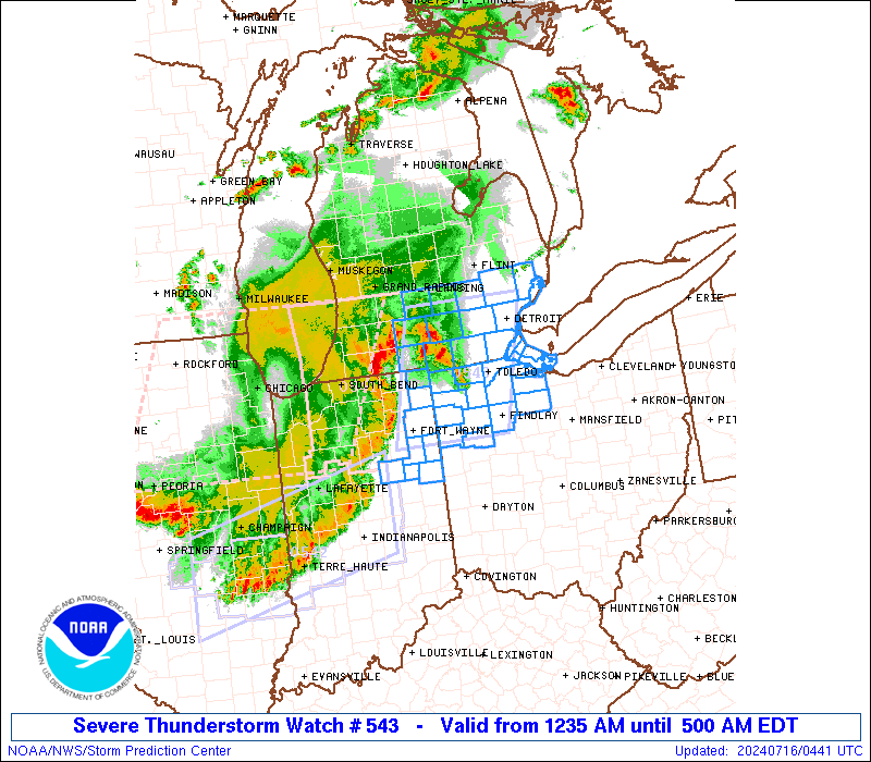
Severe Thunderstorm Watch Number 543
NWS Storm Prediction Center Norman OK
1235 AM EDT Tue Jul 16 2024
The NWS Storm Prediction Center has issued a
* Severe Thunderstorm Watch for portions of
Northeast Indiana
Southeast Lower Michigan
Northwest Ohio
Lake Erie
* Effective this Tuesday morning from 1235 AM until 500 AM EDT.
* Primary threats include...
Scattered damaging wind gusts to 70 mph possible
Isolated large hail events to 1 inch in diameter possible
A tornado or two possible
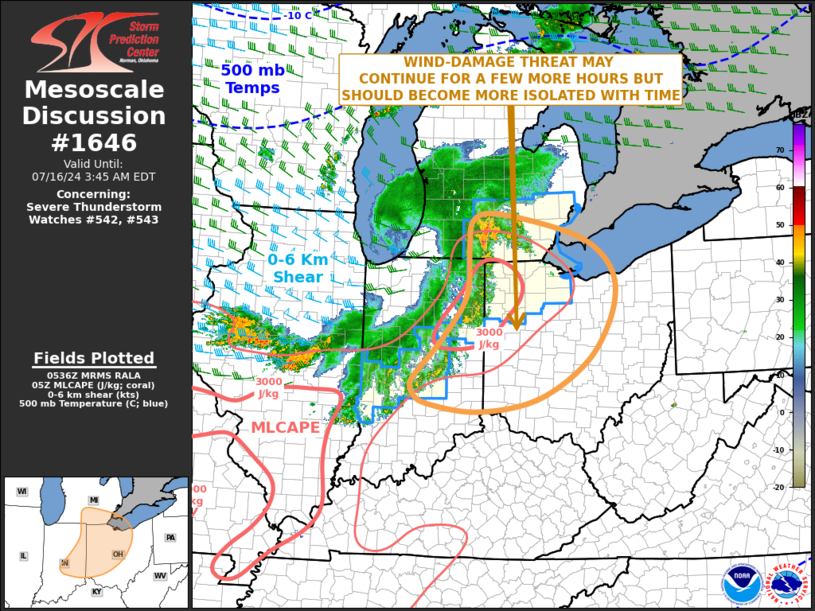
SUMMARY...A long-lived bowing line of storms will tend to weaken
slowly through the early morning hours, but occasional damaging
gusts up to 60-70 mph, isolated hail up to 1 inch in diameter and a
tornado or two with embedded circulations will remain possible in
the interim.
The severe thunderstorm watch area is approximately along and 50
statute miles east and west of a line from 30 miles northeast of
Jackson MI to 35 miles east southeast of Fort Wayne IN. For a
complete depiction of the watch see the associated watch outline
update (WOUS64 KWNS WOU3).
PRECAUTIONARY/PREPAREDNESS ACTIONS...
REMEMBER...A Severe Thunderstorm Watch means conditions are
favorable for severe thunderstorms in and close to the watch area.
Persons in these areas should be on the lookout for threatening
weather conditions and listen for later statements and possible
warnings. Severe thunderstorms can and occasionally do produce
tornadoes.
&&
OTHER WATCH INFORMATION...CONTINUE...WW 541...WW 542...
AVIATION...A few severe thunderstorms with hail surface and aloft to
1 inch. Extreme turbulence and surface wind gusts to 60 knots. A few
cumulonimbi with maximum tops to 500. Mean storm motion vector
27040.
...Thompson
   SEL3

   URGENT - IMMEDIATE BROADCAST REQUESTED
   Severe Thunderstorm Watch Number 543
   NWS Storm Prediction Center Norman OK
   1235 AM EDT Tue Jul 16 2024

   The NWS Storm Prediction Center has issued a

   * Severe Thunderstorm Watch for portions of
     Northeast Indiana
     Southeast Lower Michigan
     Northwest Ohio
     Lake Erie

   * Effective this Tuesday morning from 1235 AM until 500 AM EDT.

   * Primary threats include...
     Scattered damaging wind gusts to 70 mph possible
     Isolated large hail events to 1 inch in diameter possible
     A tornado or two possible

   SUMMARY...A long-lived bowing line of storms will tend to weaken
   slowly through the early morning hours, but occasional damaging
   gusts up to 60-70 mph, isolated hail up to 1 inch in diameter and a
   tornado or two with embedded circulations will remain possible in
   the interim.

   The severe thunderstorm watch area is approximately along and 50
   statute miles east and west of a line from 30 miles northeast of
   Jackson MI to 35 miles east southeast of Fort Wayne IN. For a
   complete depiction of the watch see the associated watch outline
   update (WOUS64 KWNS WOU3).

   PRECAUTIONARY/PREPAREDNESS ACTIONS...

   REMEMBER...A Severe Thunderstorm Watch means conditions are
   favorable for severe thunderstorms in and close to the watch area.
   Persons in these areas should be on the lookout for threatening
   weather conditions and listen for later statements and possible
   warnings. Severe thunderstorms can and occasionally do produce
   tornadoes.

   &&

   OTHER WATCH INFORMATION...CONTINUE...WW 541...WW 542...

   AVIATION...A few severe thunderstorms with hail surface and aloft to
   1 inch. Extreme turbulence and surface wind gusts to 60 knots. A few
   cumulonimbi with maximum tops to 500. Mean storm motion vector
   27040.

   ...Thompson
 Note:
The Aviation Watch (SAW) product is an approximation to the watch area.
The actual watch is depicted by the shaded areas.
Note:
The Aviation Watch (SAW) product is an approximation to the watch area.
The actual watch is depicted by the shaded areas.
   SAW3
   WW 543 SEVERE TSTM IN MI OH LE 160435Z - 160900Z
   AXIS..50 STATUTE MILES EAST AND WEST OF LINE..
   30NE JXN/JACKSON MI/ - 35ESE FWA/FORT WAYNE IN/
   ..AVIATION COORDS.. 45NM E/W /27SSW FNT - 31ESE FWA/
   HAIL SURFACE AND ALOFT..1 INCH. WIND GUSTS..60 KNOTS.
   MAX TOPS TO 500. MEAN STORM MOTION VECTOR 27040.

   LAT...LON 42578307 40788361 40788552 42578504

   THIS IS AN APPROXIMATION TO THE WATCH AREA.  FOR A
   COMPLETE DEPICTION OF THE WATCH SEE WOUS64 KWNS
   FOR WOU3.
Watch 543 Status Report Message has not been issued yet.
Note:
Click for Complete Product Text.
Tornadoes
Probability of 2 or more tornadoes
|
Low (20%)
|
Probability of 1 or more strong (EF2-EF5) tornadoes
|
Low (5%)
|
Wind
Probability of 10 or more severe wind events
|
Mod (50%)
|
Probability of 1 or more wind events > 65 knots
|
Low (10%)
|
Hail
Probability of 10 or more severe hail events
|
Low (20%)
|
Probability of 1 or more hailstones > 2 inches
|
Low (<5%)
|
Combined Severe Hail/Wind
Probability of 6 or more combined severe hail/wind events
|
Mod (60%)
|
For each watch, probabilities for particular events inside the watch
(listed above in each table) are determined by the issuing forecaster.
The "Low" category contains probability values ranging from less than 2%
to 20% (EF2-EF5 tornadoes), less than 5% to 20% (all other probabilities),
"Moderate" from 30% to 60%, and "High" from 70% to greater than 95%.
High values are bolded and lighter in color to provide awareness of
an increased threat for a particular event.


 @NWSSPC