 Note:
The expiration time in the watch graphic is amended if the watch is
replaced, cancelled or extended.
Note:
Note:
The expiration time in the watch graphic is amended if the watch is
replaced, cancelled or extended.
Note: Click for
Watch Status Reports.
SEL3
URGENT - IMMEDIATE BROADCAST REQUESTED
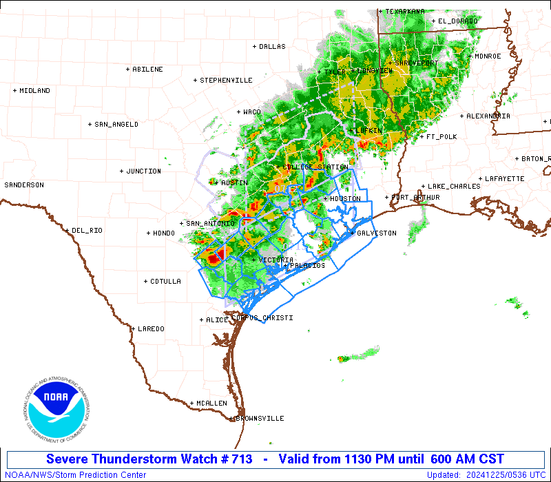
Severe Thunderstorm Watch Number 713
NWS Storm Prediction Center Norman OK
1130 PM CST Tue Dec 24 2024
The NWS Storm Prediction Center has issued a
* Severe Thunderstorm Watch for portions of
South-Central and Southeast Texas
Coastal Waters
* Effective this Tuesday night and Wednesday morning from 1130 PM
until 600 AM CST.
* Primary threats include...
Scattered damaging wind gusts to 65 mph possible
Isolated large hail events to 1.5 inches in diameter possible
A tornado or two possible
SUMMARY...Thunderstorms will spread slowly east-southeastward across
the middle/upper TX Coast through early Christmas morning. The
strongest convection will be capable of producing large hail
generally around 1-1.5 inches in diameter, along with
severe/damaging winds up to 55-65 mph. A brief tornado remains
possible with any persistent supercell.
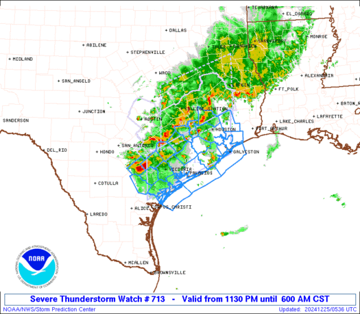
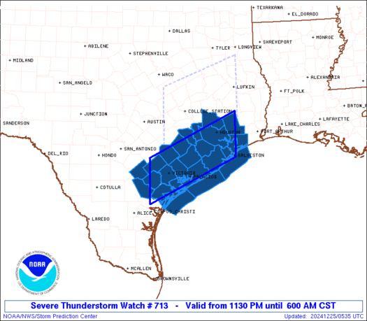
The severe thunderstorm watch area is approximately along and 45
statute miles north and south of a line from 40 miles west southwest
of Victoria TX to 40 miles north of Galveston TX. For a complete
depiction of the watch see the associated watch outline update
(WOUS64 KWNS WOU3).
PRECAUTIONARY/PREPAREDNESS ACTIONS...
REMEMBER...A Severe Thunderstorm Watch means conditions are
favorable for severe thunderstorms in and close to the watch area.
Persons in these areas should be on the lookout for threatening
weather conditions and listen for later statements and possible
warnings. Severe thunderstorms can and occasionally do produce
tornadoes.
&&
OTHER WATCH INFORMATION...CONTINUE...WW 712...
AVIATION...A few severe thunderstorms with hail surface and aloft to
1.5 inches. Extreme turbulence and surface wind gusts to 55 knots. A
few cumulonimbi with maximum tops to 450. Mean storm motion vector
28020.
...Gleason
   SEL3

   URGENT - IMMEDIATE BROADCAST REQUESTED
   Severe Thunderstorm Watch Number 713
   NWS Storm Prediction Center Norman OK
   1130 PM CST Tue Dec 24 2024

   The NWS Storm Prediction Center has issued a

   * Severe Thunderstorm Watch for portions of
     South-Central and Southeast Texas
     Coastal Waters

   * Effective this Tuesday night and Wednesday morning from 1130 PM
     until 600 AM CST.

   * Primary threats include...
     Scattered damaging wind gusts to 65 mph possible
     Isolated large hail events to 1.5 inches in diameter possible
     A tornado or two possible

   SUMMARY...Thunderstorms will spread slowly east-southeastward across
   the middle/upper TX Coast through early Christmas morning. The
   strongest convection will be capable of producing large hail
   generally around 1-1.5 inches in diameter, along with
   severe/damaging winds up to 55-65 mph. A brief tornado remains
   possible with any persistent supercell.

   The severe thunderstorm watch area is approximately along and 45
   statute miles north and south of a line from 40 miles west southwest
   of Victoria TX to 40 miles north of Galveston TX. For a complete
   depiction of the watch see the associated watch outline update
   (WOUS64 KWNS WOU3).

   PRECAUTIONARY/PREPAREDNESS ACTIONS...

   REMEMBER...A Severe Thunderstorm Watch means conditions are
   favorable for severe thunderstorms in and close to the watch area.
   Persons in these areas should be on the lookout for threatening
   weather conditions and listen for later statements and possible
   warnings. Severe thunderstorms can and occasionally do produce
   tornadoes.

   &&

   OTHER WATCH INFORMATION...CONTINUE...WW 712...

   AVIATION...A few severe thunderstorms with hail surface and aloft to
   1.5 inches. Extreme turbulence and surface wind gusts to 55 knots. A
   few cumulonimbi with maximum tops to 450. Mean storm motion vector
   28020.

   ...Gleason
 Note:
The Aviation Watch (SAW) product is an approximation to the watch area.
The actual watch is depicted by the shaded areas.
Note:
The Aviation Watch (SAW) product is an approximation to the watch area.
The actual watch is depicted by the shaded areas.
   SAW3
   WW 713 SEVERE TSTM TX CW 250530Z - 251200Z
   AXIS..45 STATUTE MILES NORTH AND SOUTH OF LINE..
   40WSW VCT/VICTORIA TX/ - 40N GLS/GALVESTON TX/
   ..AVIATION COORDS.. 40NM N/S /44N CRP - 31E IAH/
   HAIL SURFACE AND ALOFT..1.5 INCHES. WIND GUSTS..55 KNOTS.
   MAX TOPS TO 450. MEAN STORM MOTION VECTOR 28020.

   LAT...LON 29289753 30569475 29269475 27989753

   THIS IS AN APPROXIMATION TO THE WATCH AREA.  FOR A
   COMPLETE DEPICTION OF THE WATCH SEE WOUS64 KWNS
   FOR WOU3.
Watch 713 Status Report Messages:
STATUS REPORT #5 ON WW 713
VALID 251030Z - 251200Z
SEVERE WEATHER THREAT CONTINUES RIGHT OF A LINE FROM 35 ESE NIR
TO 15 SE VCT TO 20 E PSX.
WW 713 IS SCHEDULED TO EXPIRE AT 251200Z.
..GRAMS..12/25/24
ATTN...WFO...CRP...HGX...EWX...
&&
STATUS REPORT FOR WS 713
SEVERE WEATHER THREAT CONTINUES FOR THE FOLLOWING AREAS
TXC007-057-391-251200-
TX
. TEXAS COUNTIES INCLUDED ARE
ARANSAS CALHOUN REFUGIO
$$
GMZ236-237-255-330-350-251200-
CW
. ADJACENT COASTAL WATERS INCLUDED ARE
COPANO ARANSAS AND REDFISH BAYS
SAN ANTONIO MESQUITE AND ESPIRITU SANTO BAYS
COASTAL WATERS FROM PORT ARANSAS TO MATAGORDA SHIP CHANNEL OUT 20
NM
MATAGORDA BAY
COASTAL WATERS FROM FREEPORT TO MATAGORDA SHIP CHANNEL TX OUT 20
NM
$$
THE WATCH STATUS MESSAGE IS FOR GUIDANCE PURPOSES ONLY. PLEASE
REFER TO WATCH COUNTY NOTIFICATION STATEMENTS FOR OFFICIAL
INFORMATION ON COUNTIES...INDEPENDENT CITIES AND MARINE ZONES
CLEARED FROM SEVERE THUNDERSTORM AND TORNADO WATCHES.
$$
STATUS REPORT #4 ON WW 713
VALID 250935Z - 251040Z
SEVERE WEATHER THREAT CONTINUES RIGHT OF A LINE FROM 35 NNE NIR
TO 20 E LBX.
..GRAMS..12/25/24
ATTN...WFO...CRP...HGX...EWX...
&&
STATUS REPORT FOR WS 713
SEVERE WEATHER THREAT CONTINUES FOR THE FOLLOWING AREAS
TXC007-025-057-175-239-321-391-469-251040-
TX
. TEXAS COUNTIES INCLUDED ARE
ARANSAS BEE CALHOUN
GOLIAD JACKSON MATAGORDA
REFUGIO VICTORIA
$$
GMZ236-237-255-330-350-251040-
CW
. ADJACENT COASTAL WATERS INCLUDED ARE
COPANO ARANSAS AND REDFISH BAYS
SAN ANTONIO MESQUITE AND ESPIRITU SANTO BAYS
COASTAL WATERS FROM PORT ARANSAS TO MATAGORDA SHIP CHANNEL OUT 20
NM
MATAGORDA BAY
COASTAL WATERS FROM FREEPORT TO MATAGORDA SHIP CHANNEL TX OUT 20
NM
$$
THE WATCH STATUS MESSAGE IS FOR GUIDANCE PURPOSES ONLY. PLEASE
REFER TO WATCH COUNTY NOTIFICATION STATEMENTS FOR OFFICIAL
INFORMATION ON COUNTIES...INDEPENDENT CITIES AND MARINE ZONES
CLEARED FROM SEVERE THUNDERSTORM AND TORNADO WATCHES.
$$
STATUS REPORT #3 ON WW 713
VALID 250825Z - 250940Z
SEVERE WEATHER THREAT CONTINUES RIGHT OF A LINE FROM 40 N NIR TO
35 W HOU TO 50 ESE UTS.
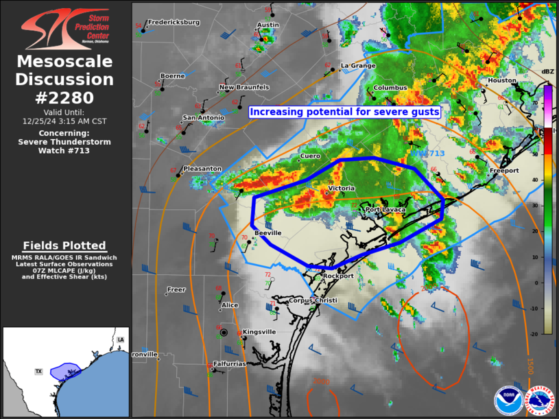
FOR ADDITIONAL INFORMATION SEE MESOSCALE DISCUSSION 2280.
..GRAMS..12/25/24
ATTN...WFO...CRP...HGX...EWX...
&&
STATUS REPORT FOR WS 713
SEVERE WEATHER THREAT CONTINUES FOR THE FOLLOWING AREAS
TXC007-025-039-057-071-123-157-167-175-201-239-255-291-321-391-
469-481-250940-
TX
. TEXAS COUNTIES INCLUDED ARE
ARANSAS BEE BRAZORIA
CALHOUN CHAMBERS DEWITT
FORT BEND GALVESTON GOLIAD
HARRIS JACKSON KARNES
LIBERTY MATAGORDA REFUGIO
VICTORIA WHARTON
$$
GMZ236-237-255-330-335-350-355-250940-
CW
. ADJACENT COASTAL WATERS INCLUDED ARE
COPANO ARANSAS AND REDFISH BAYS
SAN ANTONIO MESQUITE AND ESPIRITU SANTO BAYS
COASTAL WATERS FROM PORT ARANSAS TO MATAGORDA SHIP CHANNEL OUT 20
NM
MATAGORDA BAY
GALVESTON BAY
COASTAL WATERS FROM FREEPORT TO MATAGORDA SHIP CHANNEL TX OUT 20
NM
COASTAL WATERS FROM HIGH ISLAND TO FREEPORT TX OUT 20 NM
$$
THE WATCH STATUS MESSAGE IS FOR GUIDANCE PURPOSES ONLY. PLEASE
REFER TO WATCH COUNTY NOTIFICATION STATEMENTS FOR OFFICIAL
INFORMATION ON COUNTIES...INDEPENDENT CITIES AND MARINE ZONES
CLEARED FROM SEVERE THUNDERSTORM AND TORNADO WATCHES.
$$
STATUS REPORT #2 ON WW 713
VALID 250720Z - 250840Z
THE SEVERE WEATHER THREAT CONTINUES ACROSS THE ENTIRE WATCH AREA.
..GRAMS..12/25/24
ATTN...WFO...CRP...HGX...EWX...
&&
STATUS REPORT FOR WS 713
SEVERE WEATHER THREAT CONTINUES FOR THE FOLLOWING AREAS
TXC007-015-025-039-057-071-089-123-157-167-175-201-239-255-285-
291-321-339-391-469-473-481-250840-
TX
. TEXAS COUNTIES INCLUDED ARE
ARANSAS AUSTIN BEE
BRAZORIA CALHOUN CHAMBERS
COLORADO DEWITT FORT BEND
GALVESTON GOLIAD HARRIS
JACKSON KARNES LAVACA
LIBERTY MATAGORDA MONTGOMERY
REFUGIO VICTORIA WALLER
WHARTON
$$
GMZ236-237-255-330-335-350-355-250840-
CW
. ADJACENT COASTAL WATERS INCLUDED ARE
COPANO ARANSAS AND REDFISH BAYS
SAN ANTONIO MESQUITE AND ESPIRITU SANTO BAYS
COASTAL WATERS FROM PORT ARANSAS TO MATAGORDA SHIP CHANNEL OUT 20
NM
MATAGORDA BAY
GALVESTON BAY
COASTAL WATERS FROM FREEPORT TO MATAGORDA SHIP CHANNEL TX OUT 20
NM
COASTAL WATERS FROM HIGH ISLAND TO FREEPORT TX OUT 20 NM
$$
THE WATCH STATUS MESSAGE IS FOR GUIDANCE PURPOSES ONLY. PLEASE
REFER TO WATCH COUNTY NOTIFICATION STATEMENTS FOR OFFICIAL
INFORMATION ON COUNTIES...INDEPENDENT CITIES AND MARINE ZONES
CLEARED FROM SEVERE THUNDERSTORM AND TORNADO WATCHES.
$$
STATUS REPORT #1 ON WW 713
VALID 250640Z - 250740Z
THE SEVERE WEATHER THREAT CONTINUES ACROSS THE ENTIRE WATCH AREA.
..GRAMS..12/25/24
ATTN...WFO...CRP...HGX...EWX...
&&
STATUS REPORT FOR WS 713
SEVERE WEATHER THREAT CONTINUES FOR THE FOLLOWING AREAS
TXC007-015-025-039-057-071-089-123-157-167-175-201-239-255-285-
291-321-339-391-469-473-481-250740-
TX
. TEXAS COUNTIES INCLUDED ARE
ARANSAS AUSTIN BEE
BRAZORIA CALHOUN CHAMBERS
COLORADO DEWITT FORT BEND
GALVESTON GOLIAD HARRIS
JACKSON KARNES LAVACA
LIBERTY MATAGORDA MONTGOMERY
REFUGIO VICTORIA WALLER
WHARTON
$$
GMZ236-237-255-330-335-350-355-250740-
CW
. ADJACENT COASTAL WATERS INCLUDED ARE
COPANO ARANSAS AND REDFISH BAYS
SAN ANTONIO MESQUITE AND ESPIRITU SANTO BAYS
COASTAL WATERS FROM PORT ARANSAS TO MATAGORDA SHIP CHANNEL OUT 20
NM
MATAGORDA BAY
GALVESTON BAY
COASTAL WATERS FROM FREEPORT TO MATAGORDA SHIP CHANNEL TX OUT 20
NM
COASTAL WATERS FROM HIGH ISLAND TO FREEPORT TX OUT 20 NM
$$
THE WATCH STATUS MESSAGE IS FOR GUIDANCE PURPOSES ONLY. PLEASE
REFER TO WATCH COUNTY NOTIFICATION STATEMENTS FOR OFFICIAL
INFORMATION ON COUNTIES...INDEPENDENT CITIES AND MARINE ZONES
CLEARED FROM SEVERE THUNDERSTORM AND TORNADO WATCHES.
$$
Note:
Click for Complete Product Text.
Tornadoes
Probability of 2 or more tornadoes
|
Low (20%)
|
Probability of 1 or more strong (EF2-EF5) tornadoes
|
Low (5%)
|
Wind
Probability of 10 or more severe wind events
|
Mod (40%)
|
Probability of 1 or more wind events > 65 knots
|
Low (10%)
|
Hail
Probability of 10 or more severe hail events
|
Mod (30%)
|
Probability of 1 or more hailstones > 2 inches
|
Low (20%)
|
Combined Severe Hail/Wind
Probability of 6 or more combined severe hail/wind events
|
Mod (60%)
|
For each watch, probabilities for particular events inside the watch
(listed above in each table) are determined by the issuing forecaster.
The "Low" category contains probability values ranging from less than 2%
to 20% (EF2-EF5 tornadoes), less than 5% to 20% (all other probabilities),
"Moderate" from 30% to 60%, and "High" from 70% to greater than 95%.
High values are bolded and lighter in color to provide awareness of
an increased threat for a particular event.


 @NWSSPC