Note:
The expiration time in the watch graphic is amended if the watch is
replaced, cancelled or extended.
Note:
Note:
The expiration time in the watch graphic is amended if the watch is
replaced, cancelled or extended.
Note: Click for
Watch Status Reports.
SEL6
URGENT - IMMEDIATE BROADCAST REQUESTED
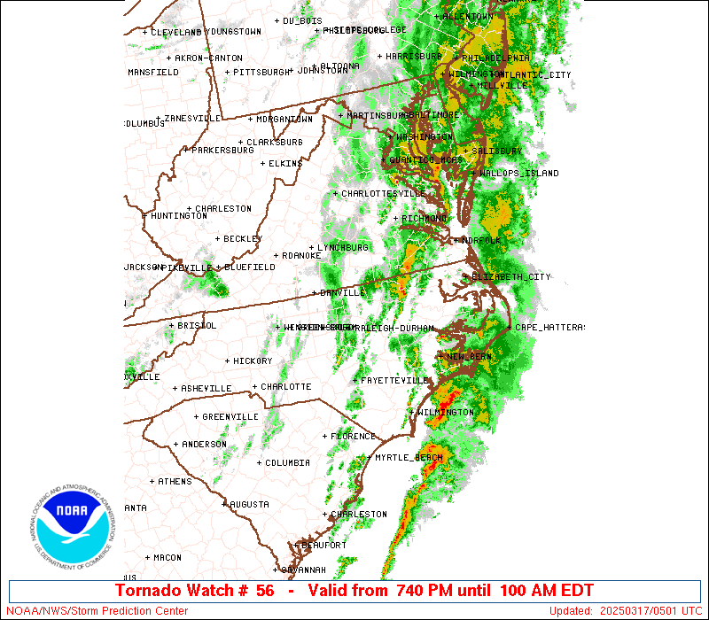
Tornado Watch Number 56
NWS Storm Prediction Center Norman OK
740 PM EDT Sun Mar 16 2025
The NWS Storm Prediction Center has issued a
* Tornado Watch for portions of
Central and Eastern North Carolina
Southern Virginia
* Effective this Sunday night and Monday morning from 740 PM
until 100 AM EDT.
* Primary threats include...
A couple tornadoes possible
Scattered damaging wind gusts to 70 mph possible
Isolated large hail events to 1.5 inches in diameter possible
SUMMARY...Scattered severe thunderstorms will move northeast across
the watch area this evening, with a risk for a couple tornadoes,
damaging gusts, and isolated large hail.
The tornado watch area is approximately along and 65 statute miles
east and west of a line from 30 miles west northwest of Richmond VA
to 20 miles east southeast of Fayetteville NC. For a complete
depiction of the watch see the associated watch outline update
(WOUS64 KWNS WOU6).
PRECAUTIONARY/PREPAREDNESS ACTIONS...
REMEMBER...A Tornado Watch means conditions are favorable for
tornadoes and severe thunderstorms in and close to the watch
area. Persons in these areas should be on the lookout for
threatening weather conditions and listen for later statements
and possible warnings.
&&
AVIATION...Tornadoes and a few severe thunderstorms with hail
surface and aloft to 1.5 inches. Extreme turbulence and surface wind
gusts to 60 knots. A few cumulonimbi with maximum tops to 450. Mean
storm motion vector 23035.
...Bunting

   SEL6

   URGENT - IMMEDIATE BROADCAST REQUESTED
   Tornado Watch Number 56
   NWS Storm Prediction Center Norman OK
   740 PM EDT Sun Mar 16 2025

   The NWS Storm Prediction Center has issued a

   * Tornado Watch for portions of
     Central and Eastern North Carolina
     Southern Virginia

   * Effective this Sunday night and Monday morning from 740 PM
     until 100 AM EDT.

   * Primary threats include...
     A couple tornadoes possible
     Scattered damaging wind gusts to 70 mph possible
     Isolated large hail events to 1.5 inches in diameter possible

   SUMMARY...Scattered severe thunderstorms will move northeast across
   the watch area this evening, with a risk for a couple tornadoes,
   damaging gusts, and isolated large hail.

   The tornado watch area is approximately along and 65 statute miles
   east and west of a line from 30 miles west northwest of Richmond VA
   to 20 miles east southeast of Fayetteville NC. For a complete
   depiction of the watch see the associated watch outline update
   (WOUS64 KWNS WOU6).

   PRECAUTIONARY/PREPAREDNESS ACTIONS...

   REMEMBER...A Tornado Watch means conditions are favorable for
   tornadoes and severe thunderstorms in and close to the watch
   area. Persons in these areas should be on the lookout for
   threatening weather conditions and listen for later statements
   and possible warnings.

   &&

   AVIATION...Tornadoes and a few severe thunderstorms with hail
   surface and aloft to 1.5 inches. Extreme turbulence and surface wind
   gusts to 60 knots. A few cumulonimbi with maximum tops to 450. Mean
   storm motion vector 23035.

   ...Bunting
 Note:
The Aviation Watch (SAW) product is an approximation to the watch area.
The actual watch is depicted by the shaded areas.
Note:
The Aviation Watch (SAW) product is an approximation to the watch area.
The actual watch is depicted by the shaded areas.
   SAW6
   WW 56 TORNADO NC VA 162340Z - 170500Z
   AXIS..65 STATUTE MILES EAST AND WEST OF LINE..
   30WNW RIC/RICHMOND VA/ - 20ESE FAY/FAYETTEVILLE NC/
   ..AVIATION COORDS.. 55NM E/W /26WNW RIC - 46NW ILM/
   HAIL SURFACE AND ALOFT..1.5 INCHES. WIND GUSTS..60 KNOTS.
   MAX TOPS TO 450. MEAN STORM MOTION VECTOR 23035.

   LAT...LON 37667662 34847741 34847969 37667901

   THIS IS AN APPROXIMATION TO THE WATCH AREA.  FOR A
   COMPLETE DEPICTION OF THE WATCH SEE WOUS64 KWNS
   FOR WOU6.
Watch 56 Status Report Messages:
STATUS REPORT #2 ON WW 56

VALID 170250Z - 170340Z

SEVERE WEATHER THREAT CONTINUES RIGHT OF A LINE FROM 40 NNW FLO
TO 25 NNW SOP TO 20 W RDU TO 25 ESE DAN TO 40 E LYH TO 10 ESE CHO.

..JEWELL..03/17/25

ATTN...WFO...RAH...MHX...AKQ...RNK...

&&

STATUS REPORT FOR WT 56

SEVERE WEATHER THREAT CONTINUES FOR THE FOLLOWING AREAS

NCC013-015-037-049-051-061-063-065-069-077-079-083-085-091-093-
101-103-105-107-117-125-127-131-133-135-147-153-163-165-181-183-
185-191-195-170340-

NC
.    NORTH CAROLINA COUNTIES INCLUDED ARE

BEAUFORT	     BERTIE		 CHATHAM
CRAVEN		     CUMBERLAND 	 DUPLIN
DURHAM		     EDGECOMBE		 FRANKLIN
GRANVILLE	     GREENE		 HALIFAX
HARNETT 	     HERTFORD		 HOKE
JOHNSTON	     JONES		 LEE
LENOIR		     MARTIN		 MOORE
NASH		     NORTHAMPTON	 ONSLOW
ORANGE		     PITT		 RICHMOND
SAMPSON 	     SCOTLAND		 VANCE
WAKE		     WARREN		 WAYNE
WILSON
$$


VAC007-025-036-041-049-053-065-075-081-087-111-117-127-135-145-
147-149-175-181-183-570-595-620-670-730-760-170340-

VA
.    VIRGINIA COUNTIES INCLUDED ARE

AMELIA		     BRUNSWICK		 CHARLES CITY
CHESTERFIELD	     CUMBERLAND 	 DINWIDDIE
FLUVANNA	     GOOCHLAND		 GREENSVILLE
HENRICO 	     LUNENBURG		 MECKLENBURG
NEW KENT	     NOTTOWAY		 POWHATAN
PRINCE EDWARD	     PRINCE GEORGE	 SOUTHAMPTON
SURRY		     SUSSEX


VIRGINIA INDEPENDENT CITIES INCLUDED ARE

COLONIAL HEIGHTS     EMPORIA		 FRANKLIN
HOPEWELL	     PETERSBURG 	 RICHMOND
$$


THE WATCH STATUS MESSAGE IS FOR GUIDANCE PURPOSES ONLY.  PLEASE
REFER TO WATCH COUNTY NOTIFICATION STATEMENTS FOR OFFICIAL
INFORMATION ON COUNTIES...INDEPENDENT CITIES AND MARINE ZONES
CLEARED FROM SEVERE THUNDERSTORM AND TORNADO WATCHES.
$$

STATUS REPORT #1 ON WW 56

VALID 170150Z - 170240Z

SEVERE WEATHER THREAT CONTINUES RIGHT OF A LINE FROM 40 ESE CLT
TO 35 WNW SOP TO 35 SSE GSO TO 20 SW DAN TO 20 NNW DAN TO 20 N
LYH.

..JEWELL..03/17/25

ATTN...WFO...RAH...MHX...AKQ...RNK...

&&

STATUS REPORT FOR WT 56

SEVERE WEATHER THREAT CONTINUES FOR THE FOLLOWING AREAS

NCC001-013-015-033-037-049-051-061-063-065-069-077-079-083-085-
091-093-101-103-105-107-117-123-125-127-131-133-135-145-147-151-
153-157-163-165-181-183-185-191-195-170240-

NC
.    NORTH CAROLINA COUNTIES INCLUDED ARE

ALAMANCE	     BEAUFORT		 BERTIE
CASWELL 	     CHATHAM		 CRAVEN
CUMBERLAND	     DUPLIN		 DURHAM
EDGECOMBE	     FRANKLIN		 GRANVILLE
GREENE		     HALIFAX		 HARNETT
HERTFORD	     HOKE		 JOHNSTON
JONES		     LEE		 LENOIR
MARTIN		     MONTGOMERY 	 MOORE
NASH		     NORTHAMPTON	 ONSLOW
ORANGE		     PERSON		 PITT
RANDOLPH	     RICHMOND		 ROCKINGHAM
SAMPSON 	     SCOTLAND		 VANCE
WAKE		     WARREN		 WAYNE
WILSON
$$


VAC007-011-025-029-031-036-037-041-049-053-065-075-081-083-087-
111-117-127-135-143-145-147-149-175-181-183-570-590-595-620-670-
730-760-170240-

VA
.    VIRGINIA COUNTIES INCLUDED ARE

AMELIA		     APPOMATTOX 	 BRUNSWICK
BUCKINGHAM	     CAMPBELL		 CHARLES CITY
CHARLOTTE	     CHESTERFIELD	 CUMBERLAND
DINWIDDIE	     FLUVANNA		 GOOCHLAND
GREENSVILLE	     HALIFAX		 HENRICO
LUNENBURG	     MECKLENBURG	 NEW KENT
NOTTOWAY	     PITTSYLVANIA	 POWHATAN
PRINCE EDWARD	     PRINCE GEORGE	 SOUTHAMPTON
SURRY		     SUSSEX


VIRGINIA INDEPENDENT CITIES INCLUDED ARE

COLONIAL HEIGHTS     DANVILLE		 EMPORIA
FRANKLIN	     HOPEWELL		 PETERSBURG
RICHMOND
$$


THE WATCH STATUS MESSAGE IS FOR GUIDANCE PURPOSES ONLY.  PLEASE
REFER TO WATCH COUNTY NOTIFICATION STATEMENTS FOR OFFICIAL
INFORMATION ON COUNTIES...INDEPENDENT CITIES AND MARINE ZONES
CLEARED FROM SEVERE THUNDERSTORM AND TORNADO WATCHES.
$$
Note:
Click for Complete Product Text.
Tornadoes
Probability of 2 or more tornadoes
|
Mod (40%)
|
Probability of 1 or more strong (EF2-EF5) tornadoes
|
Low (20%)
|
Wind
Probability of 10 or more severe wind events
|
Mod (40%)
|
Probability of 1 or more wind events > 65 knots
|
Low (20%)
|
Hail
Probability of 10 or more severe hail events
|
Low (20%)
|
Probability of 1 or more hailstones > 2 inches
|
Low (10%)
|
Combined Severe Hail/Wind
Probability of 6 or more combined severe hail/wind events
|
Mod (60%)
|
For each watch, probabilities for particular events inside the watch
(listed above in each table) are determined by the issuing forecaster.
The "Low" category contains probability values ranging from less than 2%
to 20% (EF2-EF5 tornadoes), less than 5% to 20% (all other probabilities),
"Moderate" from 30% to 60%, and "High" from 70% to greater than 95%.
High values are bolded and lighter in color to provide awareness of
an increased threat for a particular event.


 @NWSSPC