Note:
The expiration time in the watch graphic is amended if the watch is
replaced, cancelled or extended.
Note:
Note:
The expiration time in the watch graphic is amended if the watch is
replaced, cancelled or extended.
Note: Click for
Watch Status Reports.
SEL0
URGENT - IMMEDIATE BROADCAST REQUESTED
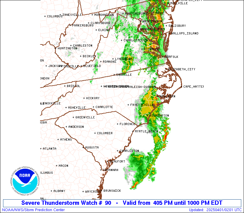
Severe Thunderstorm Watch Number 90
NWS Storm Prediction Center Norman OK
405 PM EDT Mon Mar 31 2025
The NWS Storm Prediction Center has issued a
* Severe Thunderstorm Watch for portions of
Central into Southern North Carolina
Northeast South Carolina
Coastal Waters
* Effective this Monday afternoon and evening from 405 PM until
1000 PM EDT.
* Primary threats include...
Scattered damaging wind gusts to 70 mph likely
SUMMARY...Small thunderstorm clusters and a linear band of
thunderstorms will move east across much of the Watch area this
afternoon into the evening. The stronger thunderstorms will pose
primarily a risk for scattered damaging gusts (55-70 mph).
The severe thunderstorm watch area is approximately along and 75
statute miles east and west of a line from 40 miles north northeast
of Raleigh NC to 40 miles southeast of Florence SC. For a complete
depiction of the watch see the associated watch outline update
(WOUS64 KWNS WOU0).
PRECAUTIONARY/PREPAREDNESS ACTIONS...
REMEMBER...A Severe Thunderstorm Watch means conditions are
favorable for severe thunderstorms in and close to the watch area.
Persons in these areas should be on the lookout for threatening
weather conditions and listen for later statements and possible
warnings. Severe thunderstorms can and occasionally do produce
tornadoes.
&&
OTHER WATCH INFORMATION...CONTINUE...WW 87...WW 88...WW 89...
AVIATION...A few severe thunderstorms with hail surface and aloft to
1 inch. Extreme turbulence and surface wind gusts to 60 knots. A few
cumulonimbi with maximum tops to 450. Mean storm motion vector
26040.
...Smith
 Note:
The Aviation Watch (SAW) product is an approximation to the watch area.
The actual watch is depicted by the shaded areas.
Note:
The Aviation Watch (SAW) product is an approximation to the watch area.
The actual watch is depicted by the shaded areas.
   SAW0
   WW 90 SEVERE TSTM NC SC CW 312005Z - 010200Z
   AXIS..75 STATUTE MILES EAST AND WEST OF LINE..
   40NNE RDU/RALEIGH NC/ - 40SE FLO/FLORENCE SC/
   ..AVIATION COORDS.. 65NM E/W /34NNE RDU - 35SE FLO/
   HAIL SURFACE AND ALOFT..1 INCH. WIND GUSTS..60 KNOTS.
   MAX TOPS TO 450. MEAN STORM MOTION VECTOR 26040.

   LAT...LON 36397716 33757792 33758053 36397985

   THIS IS AN APPROXIMATION TO THE WATCH AREA.  FOR A
   COMPLETE DEPICTION OF THE WATCH SEE WOUS64 KWNS
   FOR WOU0.
Watch 90 Status Report Messages:
STATUS REPORT #3 ON WW 90

VALID 010040Z - 010140Z

SEVERE WEATHER THREAT CONTINUES RIGHT OF A LINE FROM 10 ENE CRE
TO 15 SW GSB TO 5 S RZZ.

..SPC..04/01/25

ATTN...WFO...RAH...ILM...MHX...

&&

STATUS REPORT FOR WS 90

SEVERE WEATHER THREAT CONTINUES FOR THE FOLLOWING AREAS

NCC017-047-061-065-079-083-107-117-127-147-163-191-195-010140-

NC
.    NORTH CAROLINA COUNTIES INCLUDED ARE

BLADEN		     COLUMBUS		 DUPLIN
EDGECOMBE	     GREENE		 HALIFAX
LENOIR		     MARTIN		 NASH
PITT		     SAMPSON		 WAYNE
WILSON
$$


THE WATCH STATUS MESSAGE IS FOR GUIDANCE PURPOSES ONLY.  PLEASE
REFER TO WATCH COUNTY NOTIFICATION STATEMENTS FOR OFFICIAL
INFORMATION ON COUNTIES...INDEPENDENT CITIES AND MARINE ZONES
CLEARED FROM SEVERE THUNDERSTORM AND TORNADO WATCHES.
$$

STATUS REPORT #2 ON WW 90

VALID 312300Z - 010040Z

SEVERE WEATHER THREAT CONTINUES RIGHT OF A LINE FROM 30 S FLO TO
5 ENE SOP TO 20 SE DAN.

..SPC..03/31/25

ATTN...WFO...RAH...ILM...MHX...

&&

STATUS REPORT FOR WS 90

SEVERE WEATHER THREAT CONTINUES FOR THE FOLLOWING AREAS

NCC017-037-047-051-061-063-065-069-077-079-083-085-093-101-105-
107-117-125-127-135-145-147-155-163-165-181-183-185-191-195-
010040-

NC
.    NORTH CAROLINA COUNTIES INCLUDED ARE

BLADEN		     CHATHAM		 COLUMBUS
CUMBERLAND	     DUPLIN		 DURHAM
EDGECOMBE	     FRANKLIN		 GRANVILLE
GREENE		     HALIFAX		 HARNETT
HOKE		     JOHNSTON		 LEE
LENOIR		     MARTIN		 MOORE
NASH		     ORANGE		 PERSON
PITT		     ROBESON		 SAMPSON
SCOTLAND	     VANCE		 WAKE
WARREN		     WAYNE		 WILSON
$$


SCC033-041-043-051-067-089-010040-

SC
.    SOUTH CAROLINA COUNTIES INCLUDED ARE

DILLON		     FLORENCE		 GEORGETOWN
HORRY		     MARION		 WILLIAMSBURG
$$


AMZ254-256-010040-

CW

.    ADJACENT COASTAL WATERS INCLUDED ARE

COASTAL WATERS FROM LITTLE RIVER INLET TO MURRELLS INLET SC OUT
20 NM

COASTAL WATERS FROM MURRELLS INLET TO SOUTH SANTEE RIVER SC OUT
20 NM

$$
THE WATCH STATUS MESSAGE IS FOR GUIDANCE PURPOSES ONLY.  PLEASE
REFER TO WATCH COUNTY NOTIFICATION STATEMENTS FOR OFFICIAL
INFORMATION ON COUNTIES...INDEPENDENT CITIES AND MARINE ZONES
CLEARED FROM SEVERE THUNDERSTORM AND TORNADO WATCHES.
$$

STATUS REPORT #1 ON WW 90

VALID 312130Z - 312240Z

THE SEVERE WEATHER THREAT CONTINUES ACROSS THE ENTIRE WATCH AREA.

..SPC..03/31/25

ATTN...WFO...RAH...ILM...MHX...

&&

STATUS REPORT FOR WS 90

SEVERE WEATHER THREAT CONTINUES FOR THE FOLLOWING AREAS

NCC001-007-017-037-047-051-057-061-063-065-067-069-077-079-081-
083-085-093-101-105-107-117-123-125-127-135-145-147-151-153-155-
163-165-167-181-183-185-191-195-312240-

NC
.    NORTH CAROLINA COUNTIES INCLUDED ARE

ALAMANCE	     ANSON		 BLADEN
CHATHAM 	     COLUMBUS		 CUMBERLAND
DAVIDSON	     DUPLIN		 DURHAM
EDGECOMBE	     FORSYTH		 FRANKLIN
GRANVILLE	     GREENE		 GUILFORD
HALIFAX 	     HARNETT		 HOKE
JOHNSTON	     LEE		 LENOIR
MARTIN		     MONTGOMERY 	 MOORE
NASH		     ORANGE		 PERSON
PITT		     RANDOLPH		 RICHMOND
ROBESON 	     SAMPSON		 SCOTLAND
STANLY		     VANCE		 WAKE
WARREN		     WAYNE		 WILSON
$$


SCC031-033-041-043-051-067-069-089-312240-

SC
.    SOUTH CAROLINA COUNTIES INCLUDED ARE

DARLINGTON	     DILLON		 FLORENCE
GEORGETOWN	     HORRY		 MARION
MARLBORO	     WILLIAMSBURG
$$


AMZ254-256-312240-

CW

.    ADJACENT COASTAL WATERS INCLUDED ARE

COASTAL WATERS FROM LITTLE RIVER INLET TO MURRELLS INLET SC OUT
20 NM

COASTAL WATERS FROM MURRELLS INLET TO SOUTH SANTEE RIVER SC OUT
20 NM

$$
THE WATCH STATUS MESSAGE IS FOR GUIDANCE PURPOSES ONLY.  PLEASE
REFER TO WATCH COUNTY NOTIFICATION STATEMENTS FOR OFFICIAL
INFORMATION ON COUNTIES...INDEPENDENT CITIES AND MARINE ZONES
CLEARED FROM SEVERE THUNDERSTORM AND TORNADO WATCHES.
$$
Note:
Click for Complete Product Text.
Tornadoes
Probability of 2 or more tornadoes
|
Low (10%)
|
Probability of 1 or more strong (EF2-EF5) tornadoes
|
Low (<2%)
|
Wind
Probability of 10 or more severe wind events
|
Mod (60%)
|
Probability of 1 or more wind events > 65 knots
|
Low (20%)
|
Hail
Probability of 10 or more severe hail events
|
Low (10%)
|
Probability of 1 or more hailstones > 2 inches
|
Low (<5%)
|
Combined Severe Hail/Wind
Probability of 6 or more combined severe hail/wind events
|
High (70%)
|
For each watch, probabilities for particular events inside the watch
(listed above in each table) are determined by the issuing forecaster.
The "Low" category contains probability values ranging from less than 2%
to 20% (EF2-EF5 tornadoes), less than 5% to 20% (all other probabilities),
"Moderate" from 30% to 60%, and "High" from 70% to greater than 95%.
High values are bolded and lighter in color to provide awareness of
an increased threat for a particular event.


 @NWSSPC