 Note:
The expiration time in the watch graphic is amended if the watch is
replaced, cancelled or extended.
Note:
Note:
The expiration time in the watch graphic is amended if the watch is
replaced, cancelled or extended.
Note: Click for
Watch Status Reports.
SEL5
URGENT - IMMEDIATE BROADCAST REQUESTED
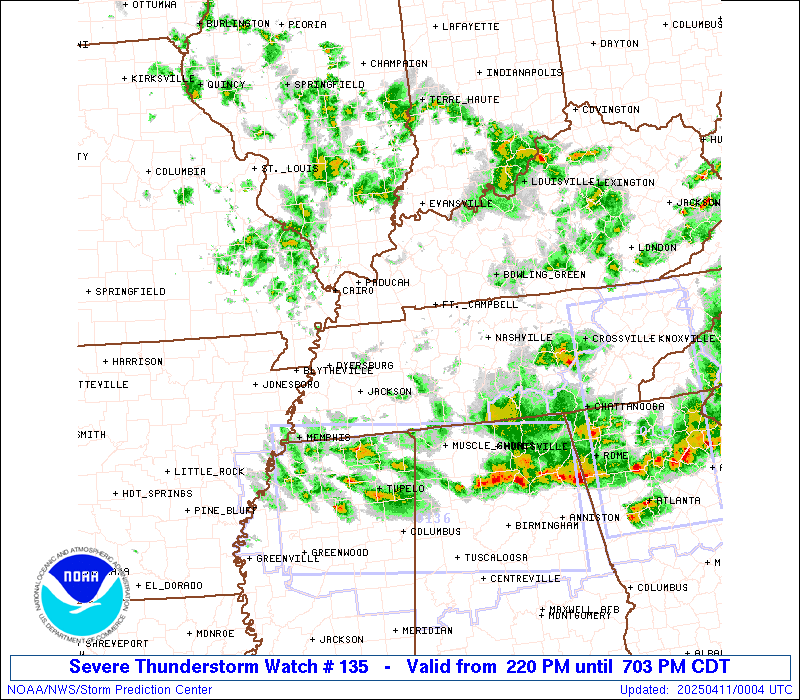
Severe Thunderstorm Watch Number 135
NWS Storm Prediction Center Norman OK
220 PM CDT Thu Apr 10 2025
The NWS Storm Prediction Center has issued a
* Severe Thunderstorm Watch for portions of
Far Northeast Arkansas
Far Southern Illinois
Western and South-Central Kentucky
Far Southeast Missouri
Western and Middle Tennessee
* Effective this Thursday afternoon and evening from 220 PM until
900 PM CDT.
* Primary threats include...
Scattered damaging wind gusts to 70 mph likely
Scattered large hail and isolated very large hail events to 2
inches in diameter possible
SUMMARY...Thunderstorms should gradually evolve east-southeastward
this afternoon and evening while posing a threat for mainly
scattered damaging winds. Peak gusts could reach up to 60-70 mph.
Occasional severe hail generally ranging from 1-1.75 inches in
diameter may also occur with any sustained supercell.
The severe thunderstorm watch area is approximately along and 65
statute miles north and south of a line from 50 miles west northwest
of Dyersburg TN to 70 miles east of Nashville TN. For a complete
depiction of the watch see the associated watch outline update
(WOUS64 KWNS WOU5).
PRECAUTIONARY/PREPAREDNESS ACTIONS...
REMEMBER...A Severe Thunderstorm Watch means conditions are
favorable for severe thunderstorms in and close to the watch area.
Persons in these areas should be on the lookout for threatening
weather conditions and listen for later statements and possible
warnings. Severe thunderstorms can and occasionally do produce
tornadoes.
&&
AVIATION...A few severe thunderstorms with hail surface and aloft to
2 inches. Extreme turbulence and surface wind gusts to 60 knots. A
few cumulonimbi with maximum tops to 450. Mean storm motion vector
31035.
...Gleason
 Note:
The Aviation Watch (SAW) product is an approximation to the watch area.
The actual watch is depicted by the shaded areas.
Note:
The Aviation Watch (SAW) product is an approximation to the watch area.
The actual watch is depicted by the shaded areas.
   SAW5
   WW 135 SEVERE TSTM AR IL KY MO TN 101920Z - 110200Z
   AXIS..65 STATUTE MILES NORTH AND SOUTH OF LINE..
   50WNW DYR/DYERSBURG TN/ - 70E BNA/NASHVILLE TN/
   ..AVIATION COORDS.. 55NM N/S /36ENE ARG - 61E BNA/
   HAIL SURFACE AND ALOFT..2 INCHES. WIND GUSTS..60 KNOTS.
   MAX TOPS TO 450. MEAN STORM MOTION VECTOR 31035.

   LAT...LON 37219023 37068543 35188543 35339023

   THIS IS AN APPROXIMATION TO THE WATCH AREA.  FOR A
   COMPLETE DEPICTION OF THE WATCH SEE WOUS64 KWNS
   FOR WOU5.
Watch 135 Status Report Messages:
STATUS REPORT #4 ON WW 135
VALID 102330Z - 110040Z
SEVERE WEATHER THREAT CONTINUES RIGHT OF A LINE FROM 35 N MSL TO
45 SSW BNA TO 20 SSE BNA TO 30 NE BNA TO 10 NW BWG.
..MARSH..04/10/25
ATTN...WFO...MEG...PAH...LMK...OHX...
&&
STATUS REPORT FOR WS 135
SEVERE WEATHER THREAT CONTINUES FOR THE FOLLOWING AREAS
KYC001-003-009-053-057-061-085-087-099-169-171-207-227-110040-
KY
. KENTUCKY COUNTIES INCLUDED ARE
ADAIR ALLEN BARREN
CLINTON CUMBERLAND EDMONSON
GRAYSON GREEN HART
METCALFE MONROE RUSSELL
WARREN
$$
TNC003-015-027-031-035-041-049-055-061-071-087-099-109-111-117-
133-137-141-149-159-165-169-175-177-185-189-110040-
TN
. TENNESSEE COUNTIES INCLUDED ARE
BEDFORD CANNON CLAY
COFFEE CUMBERLAND DE KALB
FENTRESS GILES GRUNDY
HARDIN JACKSON LAWRENCE
MCNAIRY MACON MARSHALL
OVERTON PICKETT PUTNAM
RUTHERFORD SMITH SUMNER
TROUSDALE VAN BUREN WARREN
WHITE WILSON
$$
THE WATCH STATUS MESSAGE IS FOR GUIDANCE PURPOSES ONLY. PLEASE
REFER TO WATCH COUNTY NOTIFICATION STATEMENTS FOR OFFICIAL
INFORMATION ON COUNTIES...INDEPENDENT CITIES AND MARINE ZONES
CLEARED FROM SEVERE THUNDERSTORM AND TORNADO WATCHES.
$$
STATUS REPORT #3 ON WW 135
VALID 102220Z - 102340Z
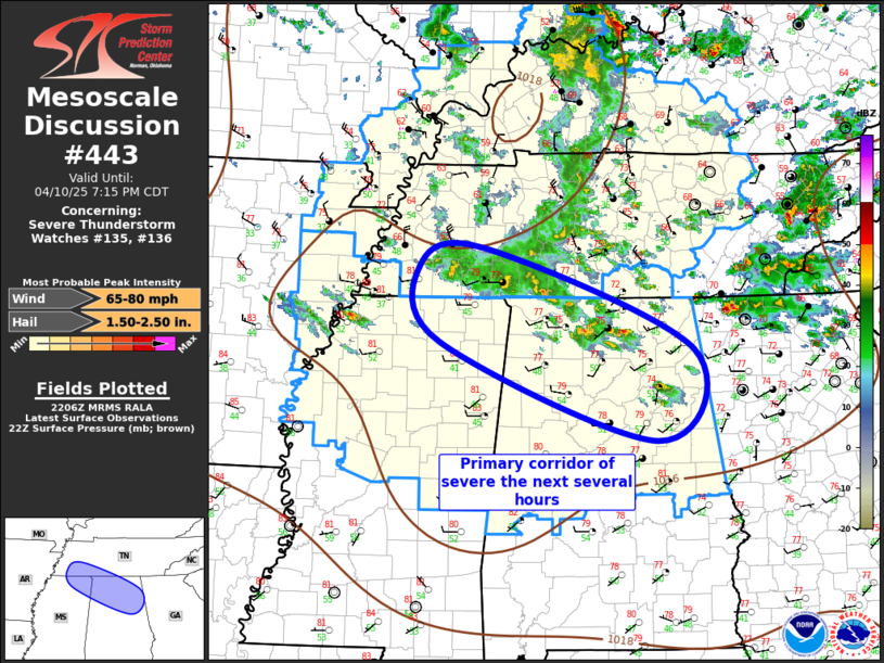
SEVERE WEATHER THREAT CONTINUES RIGHT OF A LINE FROM 20 S MKL TO
55 NNW MSL TO 45 WSW BNA TO 20 WNW BNA TO 25 ENE CKV.
FOR ADDITIONAL INFORMATION SEE MESOSCALE DISCUSSION 443
..MARSH..04/10/25
ATTN...WFO...MEG...PAH...LMK...OHX...
&&
STATUS REPORT FOR WS 135
SEVERE WEATHER THREAT CONTINUES FOR THE FOLLOWING AREAS
KYC001-003-009-031-053-057-061-085-087-099-141-169-171-183-207-
213-227-102340-
KY
. KENTUCKY COUNTIES INCLUDED ARE
ADAIR ALLEN BARREN
BUTLER CLINTON CUMBERLAND
EDMONSON GRAYSON GREEN
HART LOGAN METCALFE
MONROE OHIO RUSSELL
SIMPSON WARREN
$$
MOC143-102340-
MO
. MISSOURI COUNTIES INCLUDED ARE
NEW MADRID
$$
TNC003-015-021-023-027-031-035-037-041-043-047-049-055-061-069-
071-081-087-099-101-109-111-117-119-125-133-135-137-141-147-149-
159-165-169-175-177-181-185-187-189-102340-
TN
. TENNESSEE COUNTIES INCLUDED ARE
BEDFORD CANNON CHEATHAM
CHESTER CLAY COFFEE
CUMBERLAND DAVIDSON DE KALB
DICKSON FAYETTE FENTRESS
GILES GRUNDY HARDEMAN
HARDIN HICKMAN JACKSON
LAWRENCE LEWIS MCNAIRY
MACON MARSHALL MAURY
MONTGOMERY OVERTON PERRY
PICKETT PUTNAM ROBERTSON
RUTHERFORD SMITH SUMNER
TROUSDALE VAN BUREN WARREN
WAYNE WHITE WILLIAMSON
WILSON
$$
THE WATCH STATUS MESSAGE IS FOR GUIDANCE PURPOSES ONLY. PLEASE
REFER TO WATCH COUNTY NOTIFICATION STATEMENTS FOR OFFICIAL
INFORMATION ON COUNTIES...INDEPENDENT CITIES AND MARINE ZONES
CLEARED FROM SEVERE THUNDERSTORM AND TORNADO WATCHES.
$$
STATUS REPORT #2 ON WW 135
VALID 102130Z - 102240Z
THE SEVERE WEATHER THREAT CONTINUES ACROSS THE ENTIRE WATCH AREA.
..MARSH..04/10/25
ATTN...WFO...MEG...PAH...LMK...OHX...
&&
STATUS REPORT FOR WS 135
SEVERE WEATHER THREAT CONTINUES FOR THE FOLLOWING AREAS
ARC021-031-055-093-102240-
AR
. ARKANSAS COUNTIES INCLUDED ARE
CLAY CRAIGHEAD GREENE
MISSISSIPPI
$$
ILC003-059-069-087-127-151-153-165-181-199-102240-
IL
. ILLINOIS COUNTIES INCLUDED ARE
ALEXANDER GALLATIN HARDIN
JOHNSON MASSAC POPE
PULASKI SALINE UNION
WILLIAMSON
$$
INC051-129-147-163-173-102240-
IN
. INDIANA COUNTIES INCLUDED ARE
GIBSON POSEY SPENCER
VANDERBURGH WARRICK
$$
KYC001-003-007-009-031-033-035-039-047-053-055-057-059-061-075-
083-085-087-099-101-105-107-139-141-143-145-149-157-169-171-177-
183-207-213-219-221-225-227-233-102240-
KY
. KENTUCKY COUNTIES INCLUDED ARE
ADAIR ALLEN BALLARD
BARREN BUTLER CALDWELL
CALLOWAY CARLISLE CHRISTIAN
CLINTON CRITTENDEN CUMBERLAND
DAVIESS EDMONSON FULTON
GRAVES GRAYSON GREEN
HART HENDERSON HICKMAN
HOPKINS LIVINGSTON LOGAN
LYON MCCRACKEN MCLEAN
MARSHALL METCALFE MONROE
MUHLENBERG OHIO RUSSELL
SIMPSON TODD TRIGG
UNION WARREN WEBSTER
$$
MOC069-133-143-155-201-207-102240-
MO
. MISSOURI COUNTIES INCLUDED ARE
DUNKLIN MISSISSIPPI NEW MADRID
PEMISCOT SCOTT STODDARD
$$
TNC003-005-015-017-021-023-027-031-033-035-037-039-041-043-045-
047-049-053-055-061-069-071-075-077-079-081-083-085-087-095-097-
099-101-109-111-113-117-119-125-131-133-135-137-141-147-149-159-
161-165-167-169-175-177-181-183-185-187-189-102240-
TN
. TENNESSEE COUNTIES INCLUDED ARE
BEDFORD BENTON CANNON
CARROLL CHEATHAM CHESTER
CLAY COFFEE CROCKETT
CUMBERLAND DAVIDSON DECATUR
DE KALB DICKSON DYER
FAYETTE FENTRESS GIBSON
GILES GRUNDY HARDEMAN
HARDIN HAYWOOD HENDERSON
HENRY HICKMAN HOUSTON
HUMPHREYS JACKSON LAKE
LAUDERDALE LAWRENCE LEWIS
MCNAIRY MACON MADISON
MARSHALL MAURY MONTGOMERY
OBION OVERTON PERRY
PICKETT PUTNAM ROBERTSON
RUTHERFORD SMITH STEWART
SUMNER TIPTON TROUSDALE
VAN BUREN WARREN WAYNE
WEAKLEY WHITE WILLIAMSON
WILSON
$$
THE WATCH STATUS MESSAGE IS FOR GUIDANCE PURPOSES ONLY. PLEASE
REFER TO WATCH COUNTY NOTIFICATION STATEMENTS FOR OFFICIAL
INFORMATION ON COUNTIES...INDEPENDENT CITIES AND MARINE ZONES
CLEARED FROM SEVERE THUNDERSTORM AND TORNADO WATCHES.
$$
STATUS REPORT #1 ON WW 135
VALID 102040Z - 102140Z
THE SEVERE WEATHER THREAT CONTINUES ACROSS THE ENTIRE WATCH AREA.
..GUYER..04/10/25
ATTN...WFO...MEG...PAH...LMK...OHX...
&&
STATUS REPORT FOR WS 135
SEVERE WEATHER THREAT CONTINUES FOR THE FOLLOWING AREAS
ARC021-031-055-093-102140-
AR
. ARKANSAS COUNTIES INCLUDED ARE
CLAY CRAIGHEAD GREENE
MISSISSIPPI
$$
ILC003-059-069-087-127-151-153-165-181-199-102140-
IL
. ILLINOIS COUNTIES INCLUDED ARE
ALEXANDER GALLATIN HARDIN
JOHNSON MASSAC POPE
PULASKI SALINE UNION
WILLIAMSON
$$
KYC001-003-007-009-031-033-035-039-047-053-055-057-059-061-075-
083-085-087-099-101-105-107-139-141-143-145-149-157-169-171-177-
183-207-213-219-221-225-227-233-102140-
KY
. KENTUCKY COUNTIES INCLUDED ARE
ADAIR ALLEN BALLARD
BARREN BUTLER CALDWELL
CALLOWAY CARLISLE CHRISTIAN
CLINTON CRITTENDEN CUMBERLAND
DAVIESS EDMONSON FULTON
GRAVES GRAYSON GREEN
HART HENDERSON HICKMAN
HOPKINS LIVINGSTON LOGAN
LYON MCCRACKEN MCLEAN
MARSHALL METCALFE MONROE
MUHLENBERG OHIO RUSSELL
SIMPSON TODD TRIGG
UNION WARREN WEBSTER
$$
MOC069-133-143-155-201-207-102140-
MO
. MISSOURI COUNTIES INCLUDED ARE
DUNKLIN MISSISSIPPI NEW MADRID
PEMISCOT SCOTT STODDARD
$$
TNC003-005-015-017-021-023-027-031-033-035-037-039-041-043-045-
047-049-053-055-061-069-071-075-077-079-081-083-085-087-095-097-
099-101-109-111-113-117-119-125-131-133-135-137-141-147-149-159-
161-165-167-169-175-177-181-183-185-187-189-102140-
TN
. TENNESSEE COUNTIES INCLUDED ARE
BEDFORD BENTON CANNON
CARROLL CHEATHAM CHESTER
CLAY COFFEE CROCKETT
CUMBERLAND DAVIDSON DECATUR
DE KALB DICKSON DYER
FAYETTE FENTRESS GIBSON
GILES GRUNDY HARDEMAN
HARDIN HAYWOOD HENDERSON
HENRY HICKMAN HOUSTON
HUMPHREYS JACKSON LAKE
LAUDERDALE LAWRENCE LEWIS
MCNAIRY MACON MADISON
MARSHALL MAURY MONTGOMERY
OBION OVERTON PERRY
PICKETT PUTNAM ROBERTSON
RUTHERFORD SMITH STEWART
SUMNER TIPTON TROUSDALE
VAN BUREN WARREN WAYNE
WEAKLEY WHITE WILLIAMSON
WILSON
$$
THE WATCH STATUS MESSAGE IS FOR GUIDANCE PURPOSES ONLY. PLEASE
REFER TO WATCH COUNTY NOTIFICATION STATEMENTS FOR OFFICIAL
INFORMATION ON COUNTIES...INDEPENDENT CITIES AND MARINE ZONES
CLEARED FROM SEVERE THUNDERSTORM AND TORNADO WATCHES.
$$
Note:
Click for Complete Product Text.
Tornadoes
Probability of 2 or more tornadoes
|
Low (<5%)
|
Probability of 1 or more strong (EF2-EF5) tornadoes
|
Low (<2%)
|
Wind
Probability of 10 or more severe wind events
|
Mod (60%)
|
Probability of 1 or more wind events > 65 knots
|
Low (20%)
|
Hail
Probability of 10 or more severe hail events
|
Mod (40%)
|
Probability of 1 or more hailstones > 2 inches
|
Mod (30%)
|
Combined Severe Hail/Wind
Probability of 6 or more combined severe hail/wind events
|
High (80%)
|
For each watch, probabilities for particular events inside the watch
(listed above in each table) are determined by the issuing forecaster.
The "Low" category contains probability values ranging from less than 2%
to 20% (EF2-EF5 tornadoes), less than 5% to 20% (all other probabilities),
"Moderate" from 30% to 60%, and "High" from 70% to greater than 95%.
High values are bolded and lighter in color to provide awareness of
an increased threat for a particular event.


 @NWSSPC