|
| Mesoscale Discussion 843 |
|
< Previous MD Next MD >
|
|
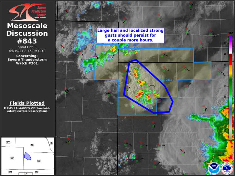
   Mesoscale Discussion 0843
   NWS Storm Prediction Center Norman OK
   0713 PM CDT Sun May 19 2024

   Areas affected...Northwest KS

   Concerning...Severe Thunderstorm Watch 261...

   Valid 200013Z - 200145Z

   The severe weather threat for Severe Thunderstorm Watch 261
   continues.

   SUMMARY...Large hail of 1 to 1.75 inches in diameter and localized
   strong gusts from 45 to 60 mph will be possible for a couple more
   hours across northwest Kansas. This activity should diminish after
   dusk.

   DISCUSSION...With a multitude of surface boundaries that collided
   across parts of northwest Kansas, a few severe thunderstorms have
   developed with reported hail up to 2 inches in diameter thus far.
   This activity will likely remain nearly stationary as subsidence
   behind the intense MCS over central KS suggests convection will
   struggle to move east from northwest KS. As such, the severe threat
   will persist through about dusk and likely diminish as MLCIN
   nocturnally increases.

   ..Grams.. 05/20/2024

   ...Please see www.spc.noaa.gov for graphic product...

   ATTN...WFO...GLD...

   LAT...LON   40060146 39420056 39020030 38770043 38740091 39200185
               40020169 40060146
|
|
Top/All Mesoscale Discussions/Forecast Products/Home
|
|


 @NWSSPC