|
| Mesoscale Discussion 894 |
|
< Previous MD Next MD >
|

|
   Mesoscale Discussion 0894
   NWS Storm Prediction Center Norman OK
   0203 PM CDT Wed May 22 2024

   Areas affected...Far Southeast Oklahoma...Far Northeast Texas...Much
   of Arkansas

   Concerning...Severe Thunderstorm Watch 284...

   Valid 221903Z - 222030Z

   The severe weather threat for Severe Thunderstorm Watch 284
   continues.

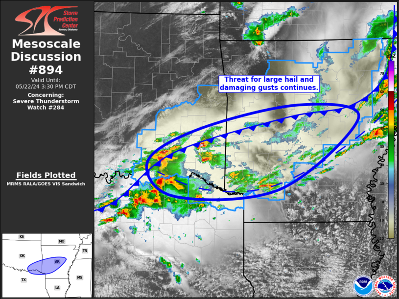
   SUMMARY...Large hail and damaging gusts remain possible from far
   southeast Oklahoma and far northeast Texas across much of Arkansas.
   Large hail and damaging gusts as the primary threats.

   DISCUSSION...The earlier convection across northwestern AR weakened
   as it moved into central portions of the state, with limited
   thunderstorm activity over the past hour or so. Farther southwest,
   an elevated thunderstorm has undergone notable
   intensification/organization as it moves across southeast OK,
   maintaining a robust updraft over much of the last hour. Strong
   buoyancy and vertical shear exist within the airmass downstream of
   this cell, suggesting the severe threat will likely persist with
   this supercell as it moves from Pushmataha County eastward into
   southern Le Flore and northern McCurtain Counties.

   Additionally, thunderstorm development continues to progress
   northeastward into the region from north-central TX. The surface
   pattern is convoluted by the ongoing precipitation, but this
   activity appears to be mostly north of the preceding storm outflow
   but still south of the primary push of cold air. As such, the threat
   for surface-based storms still exists in this area (far southeast
   OK/southwest AR) for the next few hours, with large hail and
   damaging gusts as the primary threats.

   ..Mosier.. 05/22/2024

   ...Please see www.spc.noaa.gov for graphic product...

   ATTN...WFO...LZK...SHV...TSA...FWD...OUN...

   LAT...LON   34159626 34799508 35259277 35009136 33649320 33499561
               34159626
|
|
Top/All Mesoscale Discussions/Forecast Products/Home
|
|


