|
| Mesoscale Discussion 895 |
|
< Previous MD Next MD >
|
|
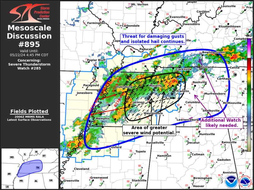
   Mesoscale Discussion 0895
   NWS Storm Prediction Center Norman OK
   0308 PM CDT Wed May 22 2024

   Areas affected...Western/Middle TN...Far Southwest/South-Central
   KY...Northern MS

   Concerning...Severe Thunderstorm Watch 285...

   Valid 222008Z - 222145Z

   The severe weather threat for Severe Thunderstorm Watch 285
   continues.

   SUMMARY...Threat for damaging gusts and isolated hail continues from
   western/middle Tennessee into southwest/south-central Kentucky, with
   a corridor of greater potential for severe gusts from western into
   northern middle TN. Additionally, a downstream watch with the next
   hour.

   DISCUSSION...Upscale growth/linear transition has occurred with the
   cells that moved across far northeast AR into far western TN, with
   the resulting convective line now moving eastward/northeastward
   across western TN. Radar imagery shows a velocity signature
   indicative of a rear-inflow jet , with limited reflective behind
   this area indicative of a descending rear-inflow jet as well.
   Expectation is for this line to progress northeastward, with the
   ongoing storms preceding the line representing a favored corridor
   for propagation. This corridor also represents an area for greater
   damaging gust potential over the next hour or so. Overall
   progression of this line will likely necessitate the need for a
   downstream watch with the next hour.

   Farther south, the ongoing cluster across far east-central
   AR/northwest MS will continue to pose a risk for isolated hail and
   damaging gusts as it moves gradually eastward across northern MS
   this afternoon.

   ..Mosier.. 05/22/2024

   ...Please see www.spc.noaa.gov for graphic product...

   ATTN...WFO...LMK...OHX...HUN...PAH...MEG...

   LAT...LON   36178974 36858831 37038587 35518568 35078736 34409025
               36178974
|
|
Top/All Mesoscale Discussions/Forecast Products/Home
|
|


 @NWSSPC