 Note:
The expiration time in the watch graphic is amended if the watch is
replaced, cancelled or extended.
Note:
Note:
The expiration time in the watch graphic is amended if the watch is
replaced, cancelled or extended.
Note: Click for
Watch Status Reports.
SEL5
URGENT - IMMEDIATE BROADCAST REQUESTED
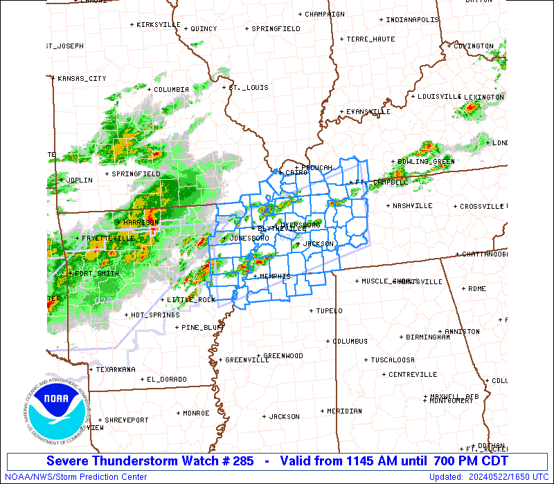
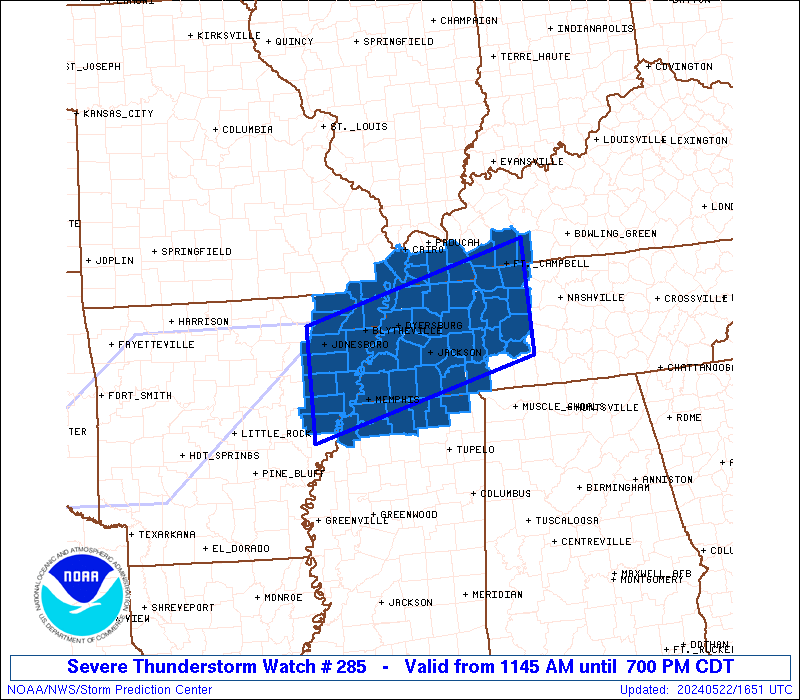
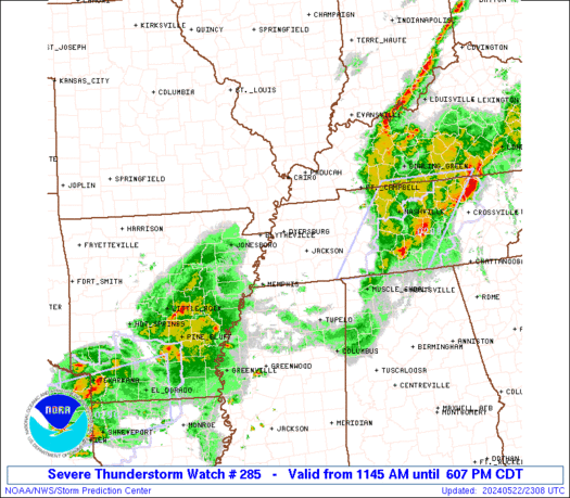
Severe Thunderstorm Watch Number 285
NWS Storm Prediction Center Norman OK
1145 AM CDT Wed May 22 2024
The NWS Storm Prediction Center has issued a
* Severe Thunderstorm Watch for portions of
Northeast Arkansas
Southwest Kentucky
Southeast Missouri
Northern Mississippi
Western Tennessee
* Effective this Wednesday morning and evening from 1145 AM until
700 PM CDT.
* Primary threats include...
Scattered damaging wind gusts to 70 mph likely
Scattered large hail and isolated very large hail events to 2
inches in diameter possible
SUMMARY...Thunderstorms that are forming over eastern Arkansas will
intensify this afternoon and spread eastward across the watch area.
Locally damaging wind gusts and hail are possible with the stronger
cells.
The severe thunderstorm watch area is approximately along and 55
statute miles north and south of a line from 40 miles south
southwest of Jonesboro AR to 30 miles south southeast of Clarksville
TN. For a complete depiction of the watch see the associated watch
outline update (WOUS64 KWNS WOU5).
PRECAUTIONARY/PREPAREDNESS ACTIONS...
REMEMBER...A Severe Thunderstorm Watch means conditions are
favorable for severe thunderstorms in and close to the watch area.
Persons in these areas should be on the lookout for threatening
weather conditions and listen for later statements and possible
warnings. Severe thunderstorms can and occasionally do produce
tornadoes.
&&
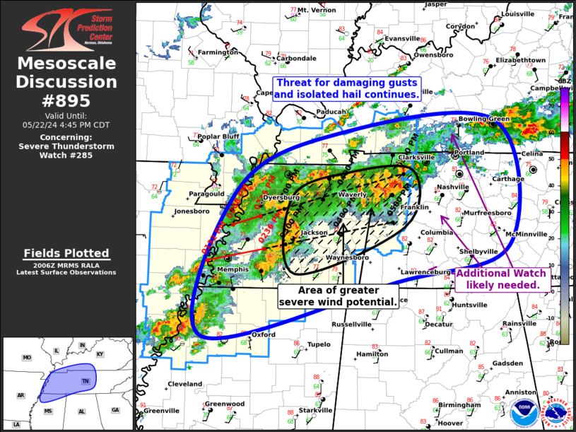
OTHER WATCH INFORMATION...CONTINUE...WW 284...
AVIATION...A few severe thunderstorms with hail surface and aloft to
2 inches. Extreme turbulence and surface wind gusts to 60 knots. A
few cumulonimbi with maximum tops to 500. Mean storm motion vector
26030.
...Hart
 Note:
The Aviation Watch (SAW) product is an approximation to the watch area.
The actual watch is depicted by the shaded areas.
Note:
The Aviation Watch (SAW) product is an approximation to the watch area.
The actual watch is depicted by the shaded areas.
   SAW5
   WW 285 SEVERE TSTM AR KY MO MS TN 221645Z - 230000Z
   AXIS..55 STATUTE MILES NORTH AND SOUTH OF LINE..
   40SSW JBR/JONESBORO AR/ - 30SSE CKV/CLARKSVILLE TN/
   ..AVIATION COORDS.. 50NM N/S /48WNW MEM - 26W BNA/
   HAIL SURFACE AND ALOFT..2 INCHES. WIND GUSTS..60 KNOTS.
   MAX TOPS TO 500. MEAN STORM MOTION VECTOR 26030.

   LAT...LON 36099092 37008721 35418721 34509092

   THIS IS AN APPROXIMATION TO THE WATCH AREA.  FOR A
   COMPLETE DEPICTION OF THE WATCH SEE WOUS64 KWNS
   FOR WOU5.
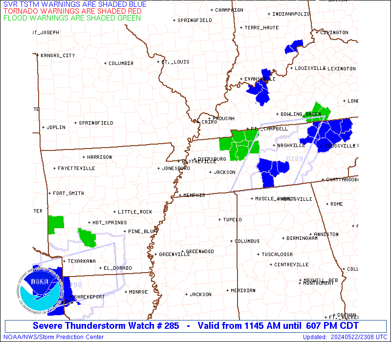
Watch 285 Status Report Messages:
STATUS REPORT #4 ON WW 285

VALID 222150Z - 222240Z

SEVERE WEATHER THREAT CONTINUES RIGHT OF A LINE FROM 30 NNE UOX
TO 15 SSW MKL TO 20 WNW BNA.

..SQUITIERI..05/22/24

ATTN...WFO...MEG...PAH...OHX...

&&

STATUS REPORT FOR WS 285

SEVERE WEATHER THREAT CONTINUES FOR THE FOLLOWING AREAS

ARC107-222240-

AR
.    ARKANSAS COUNTIES INCLUDED ARE

PHILLIPS
$$


KYC033-047-107-143-177-221-222240-

KY
.    KENTUCKY COUNTIES INCLUDED ARE

CALDWELL	     CHRISTIAN		 HOPKINS
LYON		     MUHLENBERG 	 TRIGG
$$


MSC003-009-027-033-057-071-081-093-107-115-117-119-137-139-141-
143-145-222240-

MS
.    MISSISSIPPI COUNTIES INCLUDED ARE

ALCORN		     BENTON		 COAHOMA
DESOTO		     ITAWAMBA		 LAFAYETTE
LEE		     MARSHALL		 PANOLA
PONTOTOC	     PRENTISS		 QUITMAN
TATE		     TIPPAH		 TISHOMINGO
TUNICA		     UNION
$$


TNC023-039-069-071-081-101-109-222240-

TN
.    TENNESSEE COUNTIES INCLUDED ARE

CHESTER 	     DECATUR		 HARDEMAN
HARDIN		     HICKMAN		 LEWIS
MCNAIRY
$$


THE WATCH STATUS MESSAGE IS FOR GUIDANCE PURPOSES ONLY.  PLEASE
REFER TO WATCH COUNTY NOTIFICATION STATEMENTS FOR OFFICIAL
INFORMATION ON COUNTIES...INDEPENDENT CITIES AND MARINE ZONES
CLEARED FROM SEVERE THUNDERSTORM AND TORNADO WATCHES.
$$

STATUS REPORT #3 ON WW 285

VALID 222100Z - 222240Z

SEVERE WEATHER THREAT CONTINUES RIGHT OF A LINE FROM 40 SSW JBR
TO 15 NNW MKL TO 20 SSW PAH.

..SQUITIERI..05/22/24

ATTN...WFO...MEG...PAH...OHX...

&&

STATUS REPORT FOR WS 285

SEVERE WEATHER THREAT CONTINUES FOR THE FOLLOWING AREAS

ARC035-037-077-107-123-222240-

AR
.    ARKANSAS COUNTIES INCLUDED ARE

CRITTENDEN	     CROSS		 LEE
PHILLIPS	     ST. FRANCIS
$$


KYC033-035-047-083-105-107-143-157-177-219-221-222240-

KY
.    KENTUCKY COUNTIES INCLUDED ARE

CALDWELL	     CALLOWAY		 CHRISTIAN
GRAVES		     HICKMAN		 HOPKINS
LYON		     MARSHALL		 MUHLENBERG
TODD		     TRIGG
$$


MSC003-009-027-033-057-071-081-093-107-115-117-119-137-139-141-
143-145-222240-

MS
.    MISSISSIPPI COUNTIES INCLUDED ARE

ALCORN		     BENTON		 COAHOMA
DESOTO		     ITAWAMBA		 LAFAYETTE
LEE		     MARSHALL		 PANOLA
PONTOTOC	     PRENTISS		 QUITMAN
TATE		     TIPPAH		 TISHOMINGO
TUNICA		     UNION
$$


TNC005-017-023-039-043-047-053-069-071-075-077-079-081-083-085-
101-109-113-125-135-157-161-167-183-222240-

TN
.    TENNESSEE COUNTIES INCLUDED ARE

BENTON		     CARROLL		 CHESTER
DECATUR 	     DICKSON		 FAYETTE
GIBSON		     HARDEMAN		 HARDIN
HAYWOOD 	     HENDERSON		 HENRY
HICKMAN 	     HOUSTON		 HUMPHREYS
LEWIS		     MCNAIRY		 MADISON
MONTGOMERY	     PERRY		 SHELBY
STEWART 	     TIPTON		 WEAKLEY
$$


THE WATCH STATUS MESSAGE IS FOR GUIDANCE PURPOSES ONLY.  PLEASE
REFER TO WATCH COUNTY NOTIFICATION STATEMENTS FOR OFFICIAL
INFORMATION ON COUNTIES...INDEPENDENT CITIES AND MARINE ZONES
CLEARED FROM SEVERE THUNDERSTORM AND TORNADO WATCHES.
$$

STATUS REPORT #2 ON WW 285

VALID 222005Z - 222140Z

THE SEVERE WEATHER THREAT CONTINUES ACROSS THE ENTIRE WATCH AREA.

..SQUITIERI..05/22/24

ATTN...WFO...MEG...PAH...OHX...

&&

STATUS REPORT FOR WS 285

SEVERE WEATHER THREAT CONTINUES FOR THE FOLLOWING AREAS

ARC031-035-037-077-093-111-123-222140-

AR
.    ARKANSAS COUNTIES INCLUDED ARE

CRAIGHEAD	     CRITTENDEN 	 CROSS
LEE		     MISSISSIPPI	 POINSETT
ST. FRANCIS
$$


KYC035-039-047-075-083-105-157-219-221-222140-

KY
.    KENTUCKY COUNTIES INCLUDED ARE

CALLOWAY	     CARLISLE		 CHRISTIAN
FULTON		     GRAVES		 HICKMAN
MARSHALL	     TODD		 TRIGG
$$


MSC003-009-033-093-137-139-143-222140-

MS
.    MISSISSIPPI COUNTIES INCLUDED ARE

ALCORN		     BENTON		 DESOTO
MARSHALL	     TATE		 TIPPAH
TUNICA
$$


MOC133-155-222140-

MO
.    MISSOURI COUNTIES INCLUDED ARE

MISSISSIPPI	     PEMISCOT
$$


TNC005-017-023-033-039-043-045-047-053-069-071-075-077-079-081-
083-085-095-097-101-109-113-125-131-135-157-161-167-183-
222140-

TN
.    TENNESSEE COUNTIES INCLUDED ARE

BENTON		     CARROLL		 CHESTER
CROCKETT	     DECATUR		 DICKSON
DYER		     FAYETTE		 GIBSON
HARDEMAN	     HARDIN		 HAYWOOD
HENDERSON	     HENRY		 HICKMAN
HOUSTON 	     HUMPHREYS		 LAKE
LAUDERDALE	     LEWIS		 MCNAIRY
MADISON 	     MONTGOMERY 	 OBION
PERRY		     SHELBY		 STEWART
TIPTON		     WEAKLEY
$$


THE WATCH STATUS MESSAGE IS FOR GUIDANCE PURPOSES ONLY.  PLEASE
REFER TO WATCH COUNTY NOTIFICATION STATEMENTS FOR OFFICIAL
INFORMATION ON COUNTIES...INDEPENDENT CITIES AND MARINE ZONES
CLEARED FROM SEVERE THUNDERSTORM AND TORNADO WATCHES.
$$

STATUS REPORT #1 ON WW 285

VALID 221730Z - 221840Z

THE SEVERE WEATHER THREAT CONTINUES ACROSS THE ENTIRE WATCH AREA.

..MOSIER..05/22/24

ATTN...WFO...MEG...PAH...OHX...

&&

STATUS REPORT FOR WS 285

SEVERE WEATHER THREAT CONTINUES FOR THE FOLLOWING AREAS

ARC021-031-035-037-055-077-093-111-123-221840-

AR
.    ARKANSAS COUNTIES INCLUDED ARE

CLAY		     CRAIGHEAD		 CRITTENDEN
CROSS		     GREENE		 LEE
MISSISSIPPI	     POINSETT		 ST. FRANCIS
$$


KYC035-039-047-075-083-105-157-219-221-221840-

KY
.    KENTUCKY COUNTIES INCLUDED ARE

CALLOWAY	     CARLISLE		 CHRISTIAN
FULTON		     GRAVES		 HICKMAN
MARSHALL	     TODD		 TRIGG
$$


MSC003-009-033-093-137-139-143-221840-

MS
.    MISSISSIPPI COUNTIES INCLUDED ARE

ALCORN		     BENTON		 DESOTO
MARSHALL	     TATE		 TIPPAH
TUNICA
$$


MOC069-133-143-155-221840-

MO
.    MISSOURI COUNTIES INCLUDED ARE

DUNKLIN 	     MISSISSIPPI	 NEW MADRID
PEMISCOT
$$


TNC005-017-023-033-039-043-045-047-053-069-071-075-077-079-081-
083-085-095-097-101-109-113-125-131-135-157-161-167-183-
221840-

TN
.    TENNESSEE COUNTIES INCLUDED ARE

BENTON		     CARROLL		 CHESTER
CROCKETT	     DECATUR		 DICKSON
DYER		     FAYETTE		 GIBSON
HARDEMAN	     HARDIN		 HAYWOOD
HENDERSON	     HENRY		 HICKMAN
HOUSTON 	     HUMPHREYS		 LAKE
LAUDERDALE	     LEWIS		 MCNAIRY
MADISON 	     MONTGOMERY 	 OBION
PERRY		     SHELBY		 STEWART
TIPTON		     WEAKLEY
$$


THE WATCH STATUS MESSAGE IS FOR GUIDANCE PURPOSES ONLY.  PLEASE
REFER TO WATCH COUNTY NOTIFICATION STATEMENTS FOR OFFICIAL
INFORMATION ON COUNTIES...INDEPENDENT CITIES AND MARINE ZONES
CLEARED FROM SEVERE THUNDERSTORM AND TORNADO WATCHES.
$$
Note:
Click for Complete Product Text.
Tornadoes
Probability of 2 or more tornadoes
|
Low (10%)
|
Probability of 1 or more strong (EF2-EF5) tornadoes
|
Low (<2%)
|
Wind
Probability of 10 or more severe wind events
|
Mod (60%)
|
Probability of 1 or more wind events > 65 knots
|
Low (20%)
|
Hail
Probability of 10 or more severe hail events
|
Mod (40%)
|
Probability of 1 or more hailstones > 2 inches
|
Mod (30%)
|
Combined Severe Hail/Wind
Probability of 6 or more combined severe hail/wind events
|
High (90%)
|
For each watch, probabilities for particular events inside the watch
(listed above in each table) are determined by the issuing forecaster.
The "Low" category contains probability values ranging from less than 2%
to 20% (EF2-EF5 tornadoes), less than 5% to 20% (all other probabilities),
"Moderate" from 30% to 60%, and "High" from 70% to greater than 95%.
High values are bolded and lighter in color to provide awareness of
an increased threat for a particular event.


 @NWSSPC