 Note:
The expiration time in the watch graphic is amended if the watch is
replaced, cancelled or extended.
Note:
Note:
The expiration time in the watch graphic is amended if the watch is
replaced, cancelled or extended.
Note: Click for
Watch Status Reports.
SEL4
URGENT - IMMEDIATE BROADCAST REQUESTED
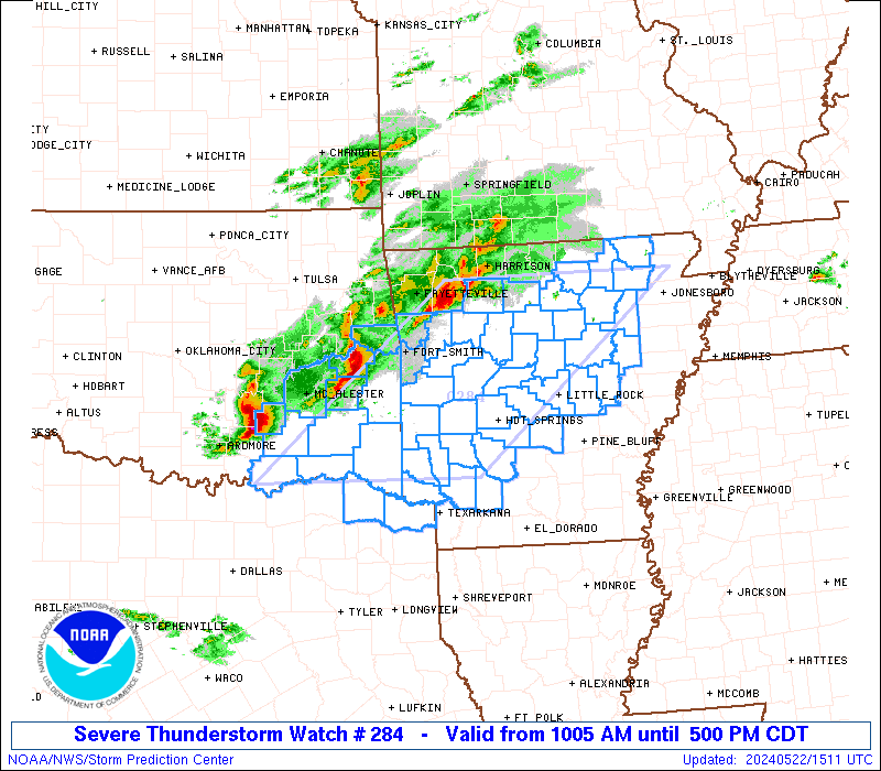
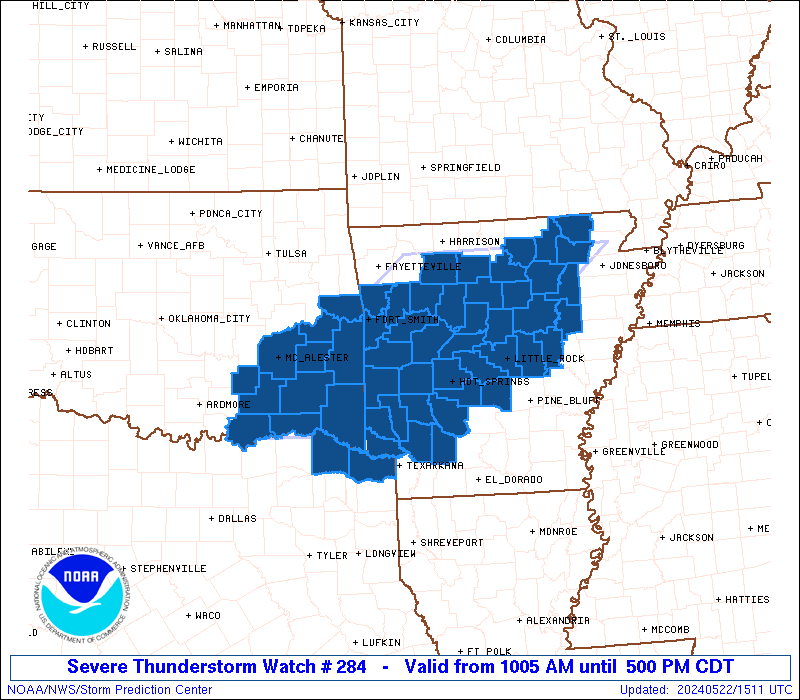
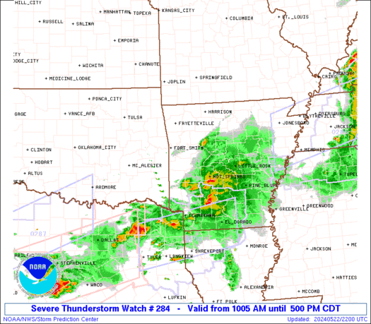
Severe Thunderstorm Watch Number 284
NWS Storm Prediction Center Norman OK
1005 AM CDT Wed May 22 2024
The NWS Storm Prediction Center has issued a
* Severe Thunderstorm Watch for portions of
Central and Western Arkansas
Southeast Oklahoma
Northeast Texas
* Effective this Wednesday morning and afternoon from 1005 AM
until 500 PM CDT.
* Primary threats include...
Scattered large hail and isolated very large hail events to 2.5
inches in diameter likely
Scattered damaging winds likely with isolated significant gusts
to 75 mph possible
A tornado or two possible
SUMMARY...Intensifying thunderstorms over eastern Oklahoma will
track across Arkansas through the afternoon, posing a risk of large
hail and damaging winds.
The severe thunderstorm watch area is approximately along and 90
statute miles east and west of a line from 35 miles west southwest
of De Queen AR to 40 miles northwest of Batesville AR. For a
complete depiction of the watch see the associated watch outline
update (WOUS64 KWNS WOU4).
PRECAUTIONARY/PREPAREDNESS ACTIONS...
REMEMBER...A Severe Thunderstorm Watch means conditions are
favorable for severe thunderstorms in and close to the watch area.
Persons in these areas should be on the lookout for threatening
weather conditions and listen for later statements and possible
warnings. Severe thunderstorms can and occasionally do produce
tornadoes.
&&
AVIATION...A few severe thunderstorms with hail surface and aloft to
2.5 inches. Extreme turbulence and surface wind gusts to 65 knots. A
few cumulonimbi with maximum tops to 500. Mean storm motion vector
27030.
...Hart

   SEL4

   URGENT - IMMEDIATE BROADCAST REQUESTED
   Severe Thunderstorm Watch Number 284
   NWS Storm Prediction Center Norman OK
   1005 AM CDT Wed May 22 2024

   The NWS Storm Prediction Center has issued a

   * Severe Thunderstorm Watch for portions of
     Central and Western Arkansas
     Southeast Oklahoma
     Northeast Texas

   * Effective this Wednesday morning and afternoon from 1005 AM
     until 500 PM CDT.

   * Primary threats include...
     Scattered large hail and isolated very large hail events to 2.5
       inches in diameter likely
     Scattered damaging winds likely with isolated significant gusts
       to 75 mph possible
     A tornado or two possible

   SUMMARY...Intensifying thunderstorms over eastern Oklahoma will
   track across Arkansas through the afternoon, posing a risk of large
   hail and damaging winds.

   The severe thunderstorm watch area is approximately along and 90
   statute miles east and west of a line from 35 miles west southwest
   of De Queen AR to 40 miles northwest of Batesville AR. For a
   complete depiction of the watch see the associated watch outline
   update (WOUS64 KWNS WOU4).

   PRECAUTIONARY/PREPAREDNESS ACTIONS...

   REMEMBER...A Severe Thunderstorm Watch means conditions are
   favorable for severe thunderstorms in and close to the watch area.
   Persons in these areas should be on the lookout for threatening
   weather conditions and listen for later statements and possible
   warnings. Severe thunderstorms can and occasionally do produce
   tornadoes.

   &&

   AVIATION...A few severe thunderstorms with hail surface and aloft to
   2.5 inches. Extreme turbulence and surface wind gusts to 65 knots. A
   few cumulonimbi with maximum tops to 500. Mean storm motion vector
   27030.

   ...Hart
 Note:
The Aviation Watch (SAW) product is an approximation to the watch area.
The actual watch is depicted by the shaded areas.
Note:
The Aviation Watch (SAW) product is an approximation to the watch area.
The actual watch is depicted by the shaded areas.
   SAW4
   WW 284 SEVERE TSTM AR OK TX 221505Z - 222200Z
   AXIS..90 STATUTE MILES EAST AND WEST OF LINE..
   35WSW DEQ/DE QUEEN AR/ - 40NW BVX/BATESVILLE AR/
   ..AVIATION COORDS.. 80NM E/W /49WNW TXK - 59W ARG/
   HAIL SURFACE AND ALOFT..2.5 INCHES. WIND GUSTS..65 KNOTS.
   MAX TOPS TO 500. MEAN STORM MOTION VECTOR 27030.

   LAT...LON 33849653 36139377 36139054 33849340

   THIS IS AN APPROXIMATION TO THE WATCH AREA.  FOR A
   COMPLETE DEPICTION OF THE WATCH SEE WOUS64 KWNS
   FOR WOU4.
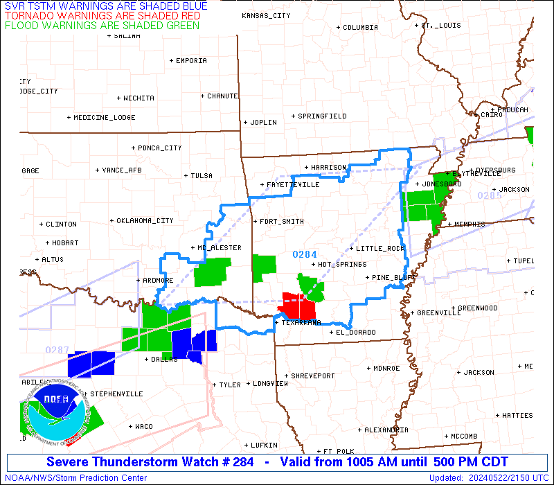
Watch 284 Status Report Messages:
STATUS REPORT #5 ON WW 284

VALID 222155Z - 222240Z

SEVERE WEATHER THREAT CONTINUES RIGHT OF A LINE FROM 40 W TXK TO
15 S DEQ TO 20 NW RUE TO 20 ENE FLP.

..BROYLES..05/22/24

ATTN...WFO...LZK...TSA...SHV...OUN...

&&

STATUS REPORT FOR WS 284

SEVERE WEATHER THREAT CONTINUES FOR THE FOLLOWING AREAS

ARC001-013-019-023-025-029-039-045-051-053-057-059-061-063-065-
067-069-075-079-081-085-095-097-099-103-105-109-115-117-119-121-
125-129-135-137-141-145-147-149-222240-

AR
.    ARKANSAS COUNTIES INCLUDED ARE

ARKANSAS	     CALHOUN		 CLARK
CLEBURNE	     CLEVELAND		 CONWAY
DALLAS		     FAULKNER		 GARLAND
GRANT		     HEMPSTEAD		 HOT SPRING
HOWARD		     INDEPENDENCE	 IZARD
JACKSON 	     JEFFERSON		 LAWRENCE
LINCOLN 	     LITTLE RIVER	 LONOKE
MONROE		     MONTGOMERY 	 NEVADA
OUACHITA	     PERRY		 PIKE
POPE		     PRAIRIE		 PULASKI
RANDOLPH	     SALINE		 SEARCY
SHARP		     STONE		 VAN BUREN
WHITE		     WOODRUFF		 YELL
$$


TXC037-222240-

TX
.    TEXAS COUNTIES INCLUDED ARE

BOWIE
$$


THE WATCH STATUS MESSAGE IS FOR GUIDANCE PURPOSES ONLY.  PLEASE
REFER TO WATCH COUNTY NOTIFICATION STATEMENTS FOR OFFICIAL
INFORMATION ON COUNTIES...INDEPENDENT CITIES AND MARINE ZONES
CLEARED FROM SEVERE THUNDERSTORM AND TORNADO WATCHES.
$$

STATUS REPORT #4 ON WW 284

VALID 222145Z - 222240Z

SEVERE WEATHER THREAT CONTINUES RIGHT OF A LINE FROM 30 SW DEQ TO
25 NNW DEQ TO 5 NE HRO.

..SQUITIERI..05/22/24

ATTN...WFO...LZK...TSA...SHV...OUN...

&&

STATUS REPORT FOR WS 284

SEVERE WEATHER THREAT CONTINUES FOR THE FOLLOWING AREAS

ARC001-013-019-023-025-029-039-045-051-053-057-059-061-063-065-
067-069-071-075-079-081-083-085-095-097-099-101-103-105-109-113-
115-117-119-121-125-127-129-133-135-137-141-145-147-149-
222240-

AR
.    ARKANSAS COUNTIES INCLUDED ARE

ARKANSAS	     CALHOUN		 CLARK
CLEBURNE	     CLEVELAND		 CONWAY
DALLAS		     FAULKNER		 GARLAND
GRANT		     HEMPSTEAD		 HOT SPRING
HOWARD		     INDEPENDENCE	 IZARD
JACKSON 	     JEFFERSON		 JOHNSON
LAWRENCE	     LINCOLN		 LITTLE RIVER
LOGAN		     LONOKE		 MONROE
MONTGOMERY	     NEVADA		 NEWTON
OUACHITA	     PERRY		 PIKE
POLK		     POPE		 PRAIRIE
PULASKI 	     RANDOLPH		 SALINE
SCOTT		     SEARCY		 SEVIER
SHARP		     STONE		 VAN BUREN
WHITE		     WOODRUFF		 YELL
$$


TXC037-387-222240-

TX
.    TEXAS COUNTIES INCLUDED ARE

BOWIE		     RED RIVER
$$


THE WATCH STATUS MESSAGE IS FOR GUIDANCE PURPOSES ONLY.  PLEASE
REFER TO WATCH COUNTY NOTIFICATION STATEMENTS FOR OFFICIAL
INFORMATION ON COUNTIES...INDEPENDENT CITIES AND MARINE ZONES
CLEARED FROM SEVERE THUNDERSTORM AND TORNADO WATCHES.
$$

STATUS REPORT #3 ON WW 284

VALID 222100Z - 222240Z

SEVERE WEATHER THREAT CONTINUES RIGHT OF A LINE FROM 25 ENE PRX
TO 25 SW FYV.

..SQUITIERI..05/22/24

ATTN...WFO...LZK...TSA...SHV...OUN...

&&

STATUS REPORT FOR WS 284

SEVERE WEATHER THREAT CONTINUES FOR THE FOLLOWING AREAS

ARC001-013-019-023-025-029-033-039-045-047-051-053-057-059-061-
063-065-067-069-071-075-079-081-083-085-095-097-099-101-103-105-
109-113-115-117-119-121-125-127-129-131-133-135-137-141-145-147-
149-222240-

AR
.    ARKANSAS COUNTIES INCLUDED ARE

ARKANSAS	     CALHOUN		 CLARK
CLEBURNE	     CLEVELAND		 CONWAY
CRAWFORD	     DALLAS		 FAULKNER
FRANKLIN	     GARLAND		 GRANT
HEMPSTEAD	     HOT SPRING 	 HOWARD
INDEPENDENCE	     IZARD		 JACKSON
JEFFERSON	     JOHNSON		 LAWRENCE
LINCOLN 	     LITTLE RIVER	 LOGAN
LONOKE		     MONROE		 MONTGOMERY
NEVADA		     NEWTON		 OUACHITA
PERRY		     PIKE		 POLK
POPE		     PRAIRIE		 PULASKI
RANDOLPH	     SALINE		 SCOTT
SEARCY		     SEBASTIAN		 SEVIER
SHARP		     STONE		 VAN BUREN
WHITE		     WOODRUFF		 YELL
$$


OKC079-089-222240-

OK
.    OKLAHOMA COUNTIES INCLUDED ARE

LE FLORE	     MCCURTAIN
$$


TXC037-387-222240-

TX
.    TEXAS COUNTIES INCLUDED ARE

BOWIE		     RED RIVER
$$


THE WATCH STATUS MESSAGE IS FOR GUIDANCE PURPOSES ONLY.  PLEASE
REFER TO WATCH COUNTY NOTIFICATION STATEMENTS FOR OFFICIAL
INFORMATION ON COUNTIES...INDEPENDENT CITIES AND MARINE ZONES
CLEARED FROM SEVERE THUNDERSTORM AND TORNADO WATCHES.
$$

STATUS REPORT #2 ON WW 284

VALID 222000Z - 222140Z

THE SEVERE WEATHER THREAT CONTINUES ACROSS THE ENTIRE WATCH AREA.

..SQUITIERI..05/22/24

ATTN...WFO...LZK...TSA...SHV...OUN...

&&

STATUS REPORT FOR WS 284

SEVERE WEATHER THREAT CONTINUES FOR THE FOLLOWING AREAS

ARC019-023-029-033-045-047-051-053-057-059-061-063-065-067-071-
075-081-083-085-097-099-101-105-109-113-115-117-119-121-125-127-
129-131-133-135-137-141-145-147-149-222140-

AR
.    ARKANSAS COUNTIES INCLUDED ARE

CLARK		     CLEBURNE		 CONWAY
CRAWFORD	     FAULKNER		 FRANKLIN
GARLAND 	     GRANT		 HEMPSTEAD
HOT SPRING	     HOWARD		 INDEPENDENCE
IZARD		     JACKSON		 JOHNSON
LAWRENCE	     LITTLE RIVER	 LOGAN
LONOKE		     MONTGOMERY 	 NEVADA
NEWTON		     PERRY		 PIKE
POLK		     POPE		 PRAIRIE
PULASKI 	     RANDOLPH		 SALINE
SCOTT		     SEARCY		 SEBASTIAN
SEVIER		     SHARP		 STONE
VAN BUREN	     WHITE		 WOODRUFF
YELL
$$


OKC005-013-023-061-077-079-089-127-135-222140-

OK
.    OKLAHOMA COUNTIES INCLUDED ARE

ATOKA		     BRYAN		 CHOCTAW
HASKELL 	     LATIMER		 LE FLORE
MCCURTAIN	     PUSHMATAHA 	 SEQUOYAH
$$


TXC037-387-222140-

TX
.    TEXAS COUNTIES INCLUDED ARE

BOWIE		     RED RIVER
$$


THE WATCH STATUS MESSAGE IS FOR GUIDANCE PURPOSES ONLY.  PLEASE
REFER TO WATCH COUNTY NOTIFICATION STATEMENTS FOR OFFICIAL
INFORMATION ON COUNTIES...INDEPENDENT CITIES AND MARINE ZONES
CLEARED FROM SEVERE THUNDERSTORM AND TORNADO WATCHES.
$$

STATUS REPORT #1 ON WW 284

VALID 221730Z - 221840Z

THE SEVERE WEATHER THREAT CONTINUES ACROSS THE ENTIRE WATCH AREA.

..MOSIER..05/22/24

ATTN...WFO...LZK...TSA...SHV...OUN...

&&

STATUS REPORT FOR WS 284

SEVERE WEATHER THREAT CONTINUES FOR THE FOLLOWING AREAS

ARC019-023-029-033-045-047-051-053-057-059-061-063-065-067-071-
075-081-083-085-097-099-101-105-109-113-115-117-119-121-125-127-
129-131-133-135-137-141-145-147-149-221840-

AR
.    ARKANSAS COUNTIES INCLUDED ARE

CLARK		     CLEBURNE		 CONWAY
CRAWFORD	     FAULKNER		 FRANKLIN
GARLAND 	     GRANT		 HEMPSTEAD
HOT SPRING	     HOWARD		 INDEPENDENCE
IZARD		     JACKSON		 JOHNSON
LAWRENCE	     LITTLE RIVER	 LOGAN
LONOKE		     MONTGOMERY 	 NEVADA
NEWTON		     PERRY		 PIKE
POLK		     POPE		 PRAIRIE
PULASKI 	     RANDOLPH		 SALINE
SCOTT		     SEARCY		 SEBASTIAN
SEVIER		     SHARP		 STONE
VAN BUREN	     WHITE		 WOODRUFF
YELL
$$


OKC005-013-023-029-061-077-079-089-121-127-135-221840-

OK
.    OKLAHOMA COUNTIES INCLUDED ARE

ATOKA		     BRYAN		 CHOCTAW
COAL		     HASKELL		 LATIMER
LE FLORE	     MCCURTAIN		 PITTSBURG
PUSHMATAHA	     SEQUOYAH
$$


TXC037-387-221840-

TX
.    TEXAS COUNTIES INCLUDED ARE

BOWIE		     RED RIVER
$$


THE WATCH STATUS MESSAGE IS FOR GUIDANCE PURPOSES ONLY.  PLEASE
REFER TO WATCH COUNTY NOTIFICATION STATEMENTS FOR OFFICIAL
INFORMATION ON COUNTIES...INDEPENDENT CITIES AND MARINE ZONES
CLEARED FROM SEVERE THUNDERSTORM AND TORNADO WATCHES.
$$
Note:
Click for Complete Product Text.
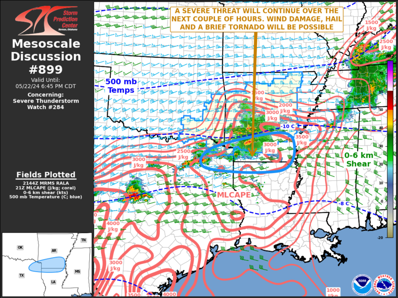
Tornadoes
Probability of 2 or more tornadoes
|
Low (20%)
|
Probability of 1 or more strong (EF2-EF5) tornadoes
|
Low (5%)
|
Wind
Probability of 10 or more severe wind events
|
Mod (60%)
|
Probability of 1 or more wind events > 65 knots
|
Mod (30%)
|
Hail
Probability of 10 or more severe hail events
|
Mod (60%)
|
Probability of 1 or more hailstones > 2 inches
|
Mod (60%)
|
Combined Severe Hail/Wind
Probability of 6 or more combined severe hail/wind events
|
High (>95%)
|
For each watch, probabilities for particular events inside the watch
(listed above in each table) are determined by the issuing forecaster.
The "Low" category contains probability values ranging from less than 2%
to 20% (EF2-EF5 tornadoes), less than 5% to 20% (all other probabilities),
"Moderate" from 30% to 60%, and "High" from 70% to greater than 95%.
High values are bolded and lighter in color to provide awareness of
an increased threat for a particular event.


 @NWSSPC