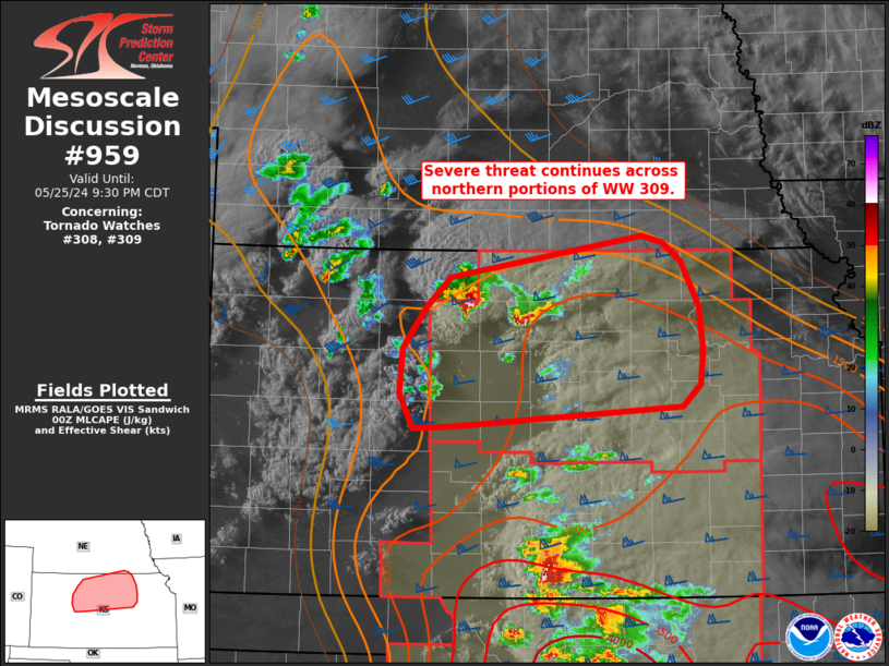
   Mesoscale Discussion 0959
   NWS Storm Prediction Center Norman OK
   0728 PM CDT Sat May 25 2024

   Areas affected...Northern Kansas into far southern Nebraska

   Concerning...Tornado Watch 308...309...

   Valid 260028Z - 260230Z

   The severe weather threat for Tornado Watch 308, 309 continues.

   SUMMARY...The severe threat continues across northern portions of WW
   309, specifically across parts of north-central Kansas into far
   south-central Nebraska.

   DISCUSSION...Over the past hour, a pair of supercells meandering
   across north-central KS have produced hail up to 1.5 inches per
   recent storm reports. 00 UTC surface observations show that moisture
   continues to stream north/northwest with dewpoints in the low 60s
   reaching the KS/NE border. Consequently, buoyancy continues to
   increase downstream of the ongoing storms and is expected to improve
   further heading into the mid/late evening hours as the surface low
   shifts east/northeast. Recent water-vapor imagery suggests lift
   associated with the primary synoptic wave is currently overspreading
   the Plains, and additional bubbling cumulus noted in GOES 1-minute
   imagery to the west of the ongoing supercells. These trends suggest
   that re-organization/intensification of ongoing convection, as well
   as new convective development, remains possible in the coming hours.
   VWPs across KS and OK are beginning to show signs of the onset of
   the nocturnal low-level jet, which should further increase low-level
   helicity heading into the late evening. Consequently, the potential
   for all severe hazards should continue across WW 309, but should be
   focused in the short-term (next couple of hours) across
   north-central KS with the ongoing convection.

   ..Moore.. 05/26/2024

   ...Please see www.spc.noaa.gov for graphic product...

   ATTN...WFO...OAX...TOP...ICT...GID...DDC...GLD...

   LAT...LON   38849660 38649679 38489932 38469977 38769992 39149989
               39519963 39769937 40139724 40069700 39909681 39519661
               39139657 38849660
|


 @NWSSPC