|
| Mesoscale Discussion 958 |
|
< Previous MD Next MD >
|
|
Mesoscale Discussion 0958
NWS Storm Prediction Center Norman OK
0607 PM CDT Sat May 25 2024
Areas affected...Northwest OK...South-Central KS
Concerning...Tornado Watch 308...
Valid 252307Z - 260030Z
The severe weather threat for Tornado Watch 308 continues.
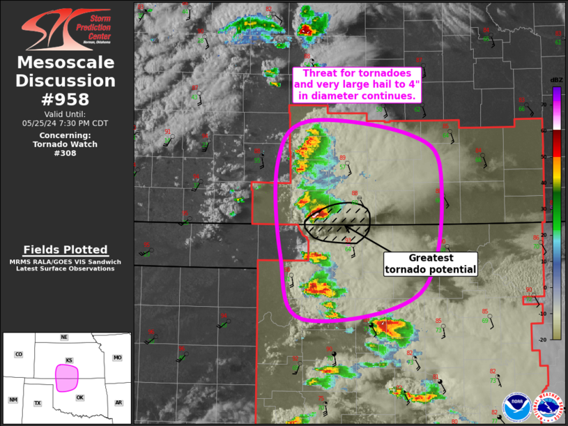
SUMMARY...Threat for tornadoes and very large hail up to 4" in
diameter continues across northwest Oklahoma and south-Central KS.
DISCUSSION...Regional radar imagery has shown several splitting
supercells over the past hour or so, with the right-moving supercell
over Comanche County KS appearing to be the strongest at this time.
Recent VAD profile from KVNX has shown a notable increase in
low-level shear, with the most recent scans sampling over 200 m2/s2
of 0-1 km storm-relative helicity. Organized structure of this storm
coupled with ample downstream shear and buoyancy suggests this storm
will likely maintain its intensity for at least the next hour.
Consequently, there is likely a corridor of greater tornado
potential for the next hour or two. Very large hail will also remain
possible with the left-split moving across Edwards County.
The storm farther south in Woodward County also has a favorable
environment downstream, but potential interactions with the
supercell moving northward across Blaine and Kingfisher casts some
doubt regarding its evolution. Even with this uncertainty, the
strength of the vertical shear suggest that eventual re-organization
is likely even if negative interference is realized. As with the
northern storms, very large hail will remain possible with any
left-splits, including the one currently moving in northern Woodward
and eastern Harper Counties.
..Mosier/Moore.. 05/25/2024
...Please see www.spc.noaa.gov for graphic product...
ATTN...WFO...ICT...OUN...DDC...
LAT...LON 37699973 38179930 38019787 37559742 36229772 35939936
36669968 37699973
|
|
Top/All Mesoscale Discussions/Forecast Products/Home
|
|


 @NWSSPC