|
| Mesoscale Discussion 1053 |
|
< Previous MD Next MD >
|
|
Mesoscale Discussion 1053
NWS Storm Prediction Center Norman OK
0349 PM CDT Tue May 28 2024
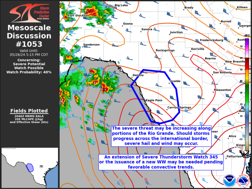
Areas affected...portions of southern Texas along the Rio Grande
Concerning...Severe potential...Watch possible
Valid 282049Z - 282215Z
Probability of Watch Issuance...40 percent
SUMMARY...The severe threat may be increasing along portions of
southern TX bordering the Rio Grande. It is unclear if the storms
can move off of the higher terrain and cross the river. Should this
occur, a severe hail/wind threat may materialize, and either an
extension of Severe Thunderstorm Watch 345 or the issuance of a new
WW may be needed.
DISCUSSION...Robust convective development, including supercells, is
occurring over the higher terrain in northeastern Mexico. These
storms are currently attempting to move off of the higher terrain,
preceded by an ambient environment characterized by 2500+ J/kg
MLCAPE and modestly curved but elongated hodographs with 60+ kts of
effective bulk shear. Strong easterly surface winds have also been
noted at observations sites along the Rio Grande, suggesting that
these storms are benefiting from abundant inflow. As such, an
appreciable risk for severe hail and wind would accompany these
storms (including the possibility of one or more instances of 2+
inch diameter hail or a 65+ kt wind gust). The main question though
is if these storms can progress off of the higher terrain and cross
the Rio Grande into TX. Confidence in this scenario is not overly
high, but convective trends are being monitored for this
possibility. Should this occur, either an extension of Severe
Thunderstorm Watch 345 or the issuance of a new Severe Thunderstorm
watch would become necessary.
..Squitieri/Hart.. 05/28/2024
...Please see www.spc.noaa.gov for graphic product...
ATTN...WFO...CRP...EWX...
LAT...LON 29140092 29560056 29509991 29069958 28449949 28259969
28160005 28200032 29140092
|
|
Top/All Mesoscale Discussions/Forecast Products/Home
|
|


 @NWSSPC