|
| Mesoscale Discussion 1131 |
|
< Previous MD Next MD >
|
|
Mesoscale Discussion 1131
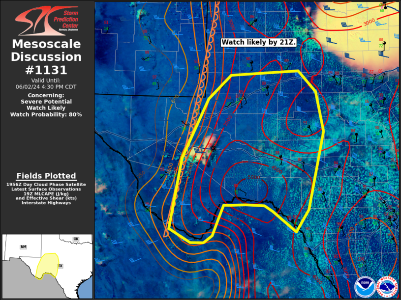
NWS Storm Prediction Center Norman OK
0301 PM CDT Sun Jun 02 2024
Areas affected...The Trans Pecos into West Texas
Concerning...Severe potential...Watch likely
Valid 022001Z - 022130Z
Probability of Watch Issuance...80 percent
SUMMARY...Storms are expected to develop within the next 1 to 2
hours with a primary threat for large to very large hail. Severe
wind gusts and a tornado or two are also possible.
DISCUSSION...Towering cu have started to cluster over the Davis
mountains with more robust storm development likely within the next
1 to 2 hours. A very moist airmass is in place which has yielded
strong to extreme instability (3000-4000 J/kg MLCAPE). Moderate
shear (~40 knots) beneath a subtropical jet streak should support
supercells with large to very large hail possible. Storm coverage is
the greater question with higher confidence of a few supercells from
the Davis Mountains southward. North of Fort Stockton, storm
coverage may remain more sparse given the lack of cu along the
dryline and separation from the forcing associated with the
mid-level shortwave trough approaching the Texas Panhandle.
Nonetheless, if any supercells form, they will pose a threat for
large hail up to baseball sized, severe wind gusts, and perhaps a
tornado.
..Bentley/Smith.. 06/02/2024
...Please see www.spc.noaa.gov for graphic product...
ATTN...WFO...EWX...SJT...MAF...
LAT...LON 29190390 30680361 31960297 32460241 32560073 32100031
31250012 29590051 29120083 29560140 29690160 29710205
29700240 29700258 29360273 29040285 28900306 28900338
29190390
|
|
Top/All Mesoscale Discussions/Forecast Products/Home
|
|


 @NWSSPC