|
| Mesoscale Discussion 1205 |
|
< Previous MD Next MD >
|
|
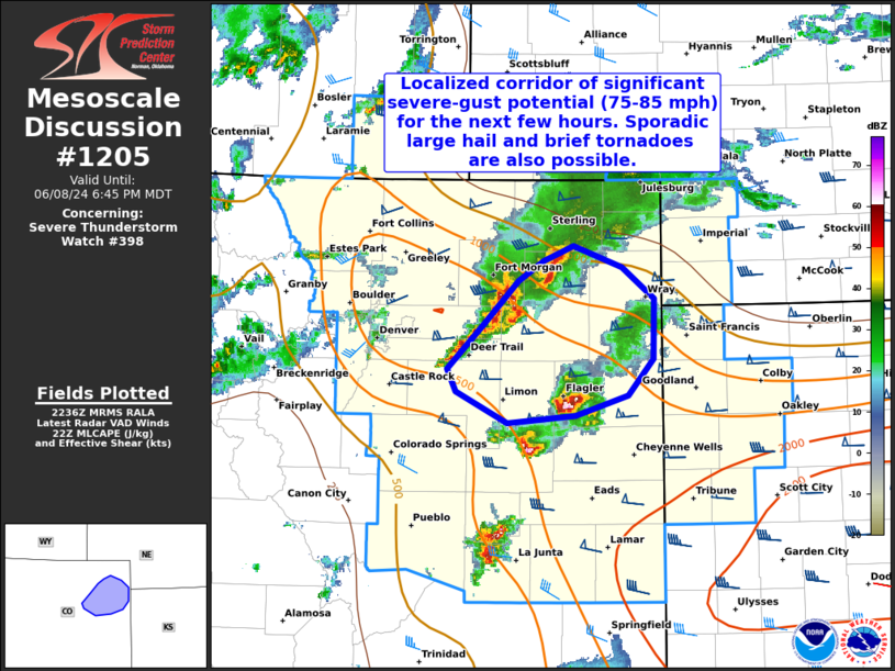
   Mesoscale Discussion 1205
   NWS Storm Prediction Center Norman OK
   0539 PM CDT Sat Jun 08 2024

   Areas affected...Portions of northeastern Colorado

   Concerning...Severe Thunderstorm Watch 398...

   Valid 082239Z - 090045Z

   The severe weather threat for Severe Thunderstorm Watch 398
   continues.

   SUMMARY...A localized corridor of significant severe-gust potential
   (75-85 mph) is evident for the next few hours across portions of
   northeast Colorado. Sporadic large hail and brief tornadoes are also
   possible.

   DISCUSSION...An upscale-growing cluster of storms is tracking
   southeastward at around 25-30 kt across portions of northeastern CO
   -- generally between I-70 and I-76. Gusts upwards of 70 mph have
   been observed with these storms. During the next few hours,
   continued upscale growth/cold pool consolidation is expected, aided
   by a glancing shortwave trough (evident in water-vapor imagery) over
   far northeastern CO. Earlier heating of a relatively moist boundary
   layer (middle/upper 50s dewpoints) beneath steep midlevel lapse
   rates should support continued surface-based inflow for intensifying
   updrafts at the leading edge of the convective line. And, around 50
   kt of westerly/line-orthogonal 0-6 km shear (sampled by regional
   VWP) should aid in organized embedded updrafts with instances of
   deep/persistent rotation. As a result, the organizing cold pool and
   embedded supercell/mesovortex structures will be capable of
   producing significant gusts of 75-85 mph as it continues
   southeastward for the next few hours. Sporadic large hail and brief
   tornadoes will also be possible, especially with the embedded
   supercells/mesovorticies.

   ..Weinman.. 06/08/2024

   ...Please see www.spc.noaa.gov for graphic product...

   ATTN...WFO...GLD...BOU...

   LAT...LON   39860388 40200352 40360327 40470295 40300245 40060212
               39580213 39280239 39120294 39070364 39310417 39500426
               39860388
|
|
Top/All Mesoscale Discussions/Forecast Products/Home
|
|


 @NWSSPC