Note:
The expiration time in the watch graphic is amended if the watch is
replaced, cancelled or extended.
Note:
Note:
The expiration time in the watch graphic is amended if the watch is
replaced, cancelled or extended.
Note: Click for
Watch Status Reports.
SEL8
URGENT - IMMEDIATE BROADCAST REQUESTED
Severe Thunderstorm Watch Number 398
NWS Storm Prediction Center Norman OK
1225 PM MDT Sat Jun 8 2024
The NWS Storm Prediction Center has issued a
* Severe Thunderstorm Watch for portions of
Eastern Colorado
Northwest Kansas
Southwest Nebraska
Far Southeast Wyoming
* Effective this Saturday afternoon and evening from 1225 PM
until 700 PM MDT.
* Primary threats include...
Scattered damaging winds likely with isolated significant gusts
to 85 mph possible
Scattered large hail likely with isolated very large hail events
to 2.5 inches in diameter possible
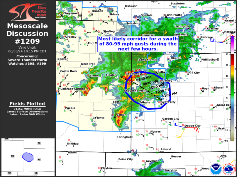
SUMMARY...Thunderstorms will continue to increase in coverage and
intensity this afternoon as they spread eastward from the Front
Range across the central High Plains. Initially large to very large
hail will be the main threat with more discrete cells. A transition
to a greater threat for significant severe winds will likely occur
as a bowing cluster eventually develops later this afternoon into
the early evening.
The severe thunderstorm watch area is approximately along and 115
statute miles north and south of a line from 10 miles west of Denver
CO to 25 miles east northeast of Burlington CO. For a complete
depiction of the watch see the associated watch outline update
(WOUS64 KWNS WOU8).
PRECAUTIONARY/PREPAREDNESS ACTIONS...
REMEMBER...A Severe Thunderstorm Watch means conditions are
favorable for severe thunderstorms in and close to the watch area.
Persons in these areas should be on the lookout for threatening
weather conditions and listen for later statements and possible
warnings. Severe thunderstorms can and occasionally do produce
tornadoes.
&&
AVIATION...A few severe thunderstorms with hail surface and aloft to
2.5 inches. Extreme turbulence and surface wind gusts to 75 knots. A
few cumulonimbi with maximum tops to 500. Mean storm motion vector
28035.
...Gleason
 Note:
The Aviation Watch (SAW) product is an approximation to the watch area.
The actual watch is depicted by the shaded areas.
Note:
The Aviation Watch (SAW) product is an approximation to the watch area.
The actual watch is depicted by the shaded areas.
   SAW8
   WW 398 SEVERE TSTM CO KS NE WY 081825Z - 090100Z
   AXIS..115 STATUTE MILES NORTH AND SOUTH OF LINE..
   10W DEN/DENVER CO/ - 25ENE ITR/BURLINGTON CO/
   ..AVIATION COORDS.. 100NM N/S /19W DEN - 7W GLD/
   HAIL SURFACE AND ALOFT..2.5 INCHES. WIND GUSTS..75 KNOTS.
   MAX TOPS TO 500. MEAN STORM MOTION VECTOR 28035.

   LAT...LON 41430507 41040185 37710185 38110507

   THIS IS AN APPROXIMATION TO THE WATCH AREA.  FOR A
   COMPLETE DEPICTION OF THE WATCH SEE WOUS64 KWNS
   FOR WOU8.
Watch 398 Status Report Messages:
STATUS REPORT #1 ON WW 398

VALID 082310Z - 090040Z

SEVERE WEATHER THREAT CONTINUES RIGHT OF A LINE FROM 45 W DEN TO
30 E SNY.

..THORNTON..06/08/24

ATTN...WFO...BOU...PUB...GLD...LBF...CYS...

&&

STATUS REPORT FOR WS 398

SEVERE WEATHER THREAT CONTINUES FOR THE FOLLOWING AREAS

COC001-005-011-017-025-031-035-039-041-059-061-063-073-075-087-
089-095-099-101-115-121-125-090040-

CO
.    COLORADO COUNTIES INCLUDED ARE

ADAMS		     ARAPAHOE		 BENT
CHEYENNE	     CROWLEY		 DENVER
DOUGLAS 	     ELBERT		 EL PASO
JEFFERSON	     KIOWA		 KIT CARSON
LINCOLN 	     LOGAN		 MORGAN
OTERO		     PHILLIPS		 PROWERS
PUEBLO		     SEDGWICK		 WASHINGTON
YUMA
$$


KSC023-071-109-181-193-199-203-090040-

KS
.    KANSAS COUNTIES INCLUDED ARE

CHEYENNE	     GREELEY		 LOGAN
SHERMAN 	     THOMAS		 WALLACE
WICHITA
$$


NEC029-057-135-090040-

NE
.    NEBRASKA COUNTIES INCLUDED ARE

CHASE		     DUNDY		 PERKINS
$$


THE WATCH STATUS MESSAGE IS FOR GUIDANCE PURPOSES ONLY.  PLEASE
REFER TO WATCH COUNTY NOTIFICATION STATEMENTS FOR OFFICIAL
INFORMATION ON COUNTIES...INDEPENDENT CITIES AND MARINE ZONES
CLEARED FROM SEVERE THUNDERSTORM AND TORNADO WATCHES.
$$
Note:
Click for Complete Product Text.
Tornadoes
Probability of 2 or more tornadoes
|
Low (10%)
|
Probability of 1 or more strong (EF2-EF5) tornadoes
|
Low (5%)
|
Wind
Probability of 10 or more severe wind events
|
High (70%)
|
Probability of 1 or more wind events > 65 knots
|
Mod (50%)
|
Hail
Probability of 10 or more severe hail events
|
Mod (60%)
|
Probability of 1 or more hailstones > 2 inches
|
Mod (40%)
|
Combined Severe Hail/Wind
Probability of 6 or more combined severe hail/wind events
|
High (90%)
|
For each watch, probabilities for particular events inside the watch
(listed above in each table) are determined by the issuing forecaster.
The "Low" category contains probability values ranging from less than 2%
to 20% (EF2-EF5 tornadoes), less than 5% to 20% (all other probabilities),
"Moderate" from 30% to 60%, and "High" from 70% to greater than 95%.
High values are bolded and lighter in color to provide awareness of
an increased threat for a particular event.


 @NWSSPC