Note:
The expiration time in the watch graphic is amended if the watch is
replaced, cancelled or extended.
Note:
Note:
The expiration time in the watch graphic is amended if the watch is
replaced, cancelled or extended.
Note: Click for
Watch Status Reports.
SEL9
URGENT - IMMEDIATE BROADCAST REQUESTED
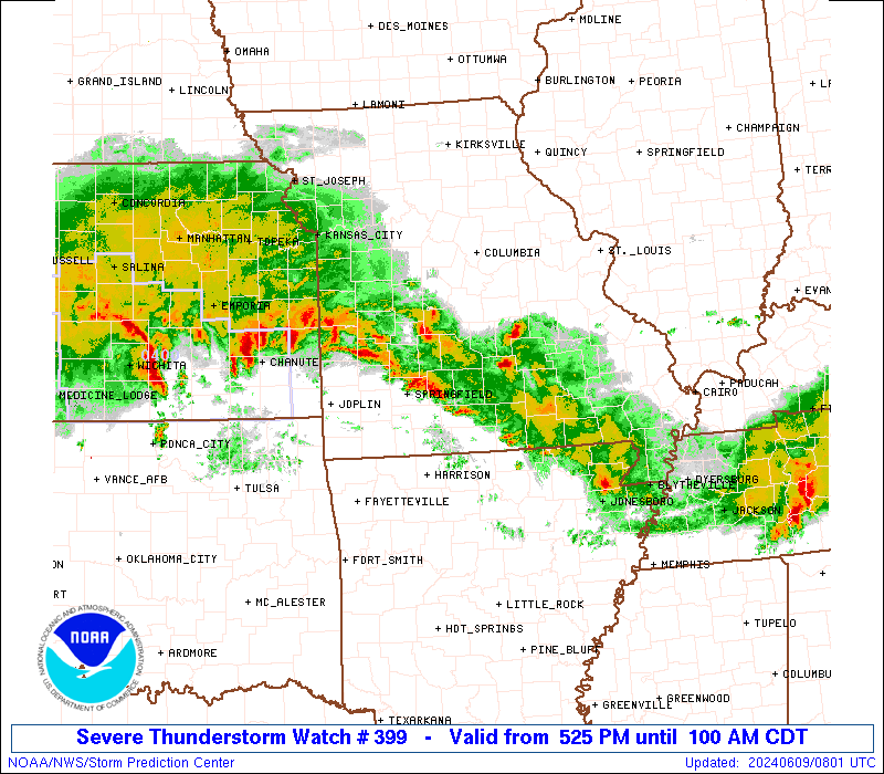
Severe Thunderstorm Watch Number 399
NWS Storm Prediction Center Norman OK
525 PM CDT Sat Jun 8 2024
The NWS Storm Prediction Center has issued a
* Severe Thunderstorm Watch for portions of
Northern Arkansas
Far Southeast Kansas
Southern Missouri
* Effective this Saturday afternoon and Sunday morning from 525
PM until 100 AM CDT.
* Primary threats include...
Scattered large hail and isolated very large hail events to 2.5
inches in diameter possible
Scattered damaging wind gusts to 70 mph possible
A tornado or two possible
SUMMARY...Severe thunderstorms will increase in coverage and move
southeast across the watch area through late this evening. Damaging
wind gusts are expected, in addition to large hail. possibly up to
2.5 inches in diameter. In addition, a tornado or two will also be
possible.
The severe thunderstorm watch area is approximately along and 55
statute miles north and south of a line from 45 miles north
northwest of Joplin MO to 20 miles northeast of Poplar Bluff MO. For
a complete depiction of the watch see the associated watch outline
update (WOUS64 KWNS WOU9).
PRECAUTIONARY/PREPAREDNESS ACTIONS...
REMEMBER...A Severe Thunderstorm Watch means conditions are
favorable for severe thunderstorms in and close to the watch area.
Persons in these areas should be on the lookout for threatening
weather conditions and listen for later statements and possible
warnings. Severe thunderstorms can and occasionally do produce
tornadoes.
&&
OTHER WATCH INFORMATION...CONTINUE...WW 398...
AVIATION...A few severe thunderstorms with hail surface and aloft to
2.5 inches. Extreme turbulence and surface wind gusts to 60 knots. A
few cumulonimbi with maximum tops to 600. Mean storm motion vector
30025.
...Bunting

SEL9
URGENT - IMMEDIATE BROADCAST REQUESTED
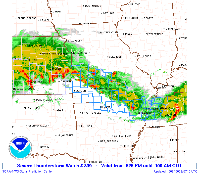
Severe Thunderstorm Watch Number 399
NWS Storm Prediction Center Norman OK
525 PM CDT Sat Jun 8 2024
The NWS Storm Prediction Center has issued a
* Severe Thunderstorm Watch for portions of
Northern Arkansas
Far Southeast Kansas
Southern Missouri
* Effective this Saturday afternoon and Sunday morning from 525
PM until 100 AM CDT.
* Primary threats include...
Scattered large hail and isolated very large hail events to 2.5
inches in diameter possible
Scattered damaging wind gusts to 70 mph possible
A tornado or two possible
SUMMARY...Severe thunderstorms will increase in coverage and move
southeast across the watch area through late this evening. Damaging
wind gusts are expected, in addition to large hail. possibly up to
2.5 inches in diameter. In addition, a tornado or two will also be
possible.
The severe thunderstorm watch area is approximately along and 55
statute miles north and south of a line from 45 miles north
northwest of Joplin MO to 20 miles northeast of Poplar Bluff MO. For
a complete depiction of the watch see the associated watch outline
update (WOUS64 KWNS WOU9).
PRECAUTIONARY/PREPAREDNESS ACTIONS...
REMEMBER...A Severe Thunderstorm Watch means conditions are
favorable for severe thunderstorms in and close to the watch area.
Persons in these areas should be on the lookout for threatening
weather conditions and listen for later statements and possible
warnings. Severe thunderstorms can and occasionally do produce
tornadoes.
&&
OTHER WATCH INFORMATION...CONTINUE...WW 398...
AVIATION...A few severe thunderstorms with hail surface and aloft to
2.5 inches. Extreme turbulence and surface wind gusts to 60 knots. A
few cumulonimbi with maximum tops to 600. Mean storm motion vector
30025.
...Bunting
 Note:
The Aviation Watch (SAW) product is an approximation to the watch area.
The actual watch is depicted by the shaded areas.
Note:
The Aviation Watch (SAW) product is an approximation to the watch area.
The actual watch is depicted by the shaded areas.
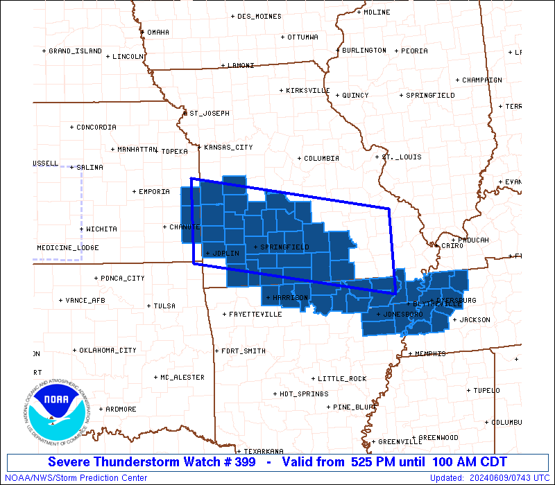
   SAW9
   WW 399 SEVERE TSTM AR KS MO 082225Z - 090600Z
   AXIS..55 STATUTE MILES NORTH AND SOUTH OF LINE..
   45NNW JLN/JOPLIN MO/ - 20NE POF/POPLAR BLUFF MO/
   ..AVIATION COORDS.. 50NM N/S /35SSW BUM - 42S FAM/
   HAIL SURFACE AND ALOFT..2.5 INCHES. WIND GUSTS..60 KNOTS.
   MAX TOPS TO 600. MEAN STORM MOTION VECTOR 30025.

   LAT...LON 38559482 37779021 36189021 36969482

   THIS IS AN APPROXIMATION TO THE WATCH AREA.  FOR A
   COMPLETE DEPICTION OF THE WATCH SEE WOUS64 KWNS
   FOR WOU9.
Watch 399 Status Report Messages:
STATUS REPORT #4 ON WW 399

VALID 090330Z - 090440Z

THE SEVERE WEATHER THREAT CONTINUES ACROSS THE ENTIRE WATCH AREA.

..SPC..06/09/24

ATTN...WFO...LZK...MEG...SGF...EAX...PAH...LSX...

&&

STATUS REPORT FOR WS 399

SEVERE WEATHER THREAT CONTINUES FOR THE FOLLOWING AREAS

ARC005-009-021-049-055-065-075-089-121-135-090440-

AR
.    ARKANSAS COUNTIES INCLUDED ARE

BAXTER		     BOONE		 CLAY
FULTON		     GREENE		 IZARD
LAWRENCE	     MARION		 RANDOLPH
SHARP
$$


KSC011-021-037-107-090440-

KS
.    KANSAS COUNTIES INCLUDED ARE

BOURBON 	     CHEROKEE		 CRAWFORD
LINN
$$


MOC009-011-013-015-023-029-035-039-043-055-057-059-065-067-077-
083-085-091-093-097-105-109-119-123-125-131-141-145-149-153-161-
167-169-179-181-185-186-187-203-209-213-215-217-221-223-225-229-
090440-

MO
.    MISSOURI COUNTIES INCLUDED ARE

BARRY		     BARTON		 BATES
BENTON		     BUTLER		 CAMDEN
CARTER		     CEDAR		 CHRISTIAN
CRAWFORD	     DADE		 DALLAS
DENT		     DOUGLAS		 GREENE
HENRY		     HICKORY		 HOWELL
IRON		     JASPER		 LACLEDE
LAWRENCE	     MCDONALD		 MADISON
MARIES		     MILLER		 MORGAN
NEWTON		     OREGON		 OZARK
PHELPS		     POLK		 PULASKI
REYNOLDS	     RIPLEY		 ST. CLAIR
STE. GENEVIEVE	     ST. FRANCOIS	 SHANNON
STONE		     TANEY		 TEXAS
VERNON		     WASHINGTON 	 WAYNE
WEBSTER 	     WRIGHT
$$


THE WATCH STATUS MESSAGE IS FOR GUIDANCE PURPOSES ONLY.  PLEASE
REFER TO WATCH COUNTY NOTIFICATION STATEMENTS FOR OFFICIAL
INFORMATION ON COUNTIES...INDEPENDENT CITIES AND MARINE ZONES
CLEARED FROM SEVERE THUNDERSTORM AND TORNADO WATCHES.
$$

STATUS REPORT #3 ON WW 399

VALID 090240Z - 090340Z

THE SEVERE WEATHER THREAT CONTINUES ACROSS THE ENTIRE WATCH AREA.

..SPC..06/09/24

ATTN...WFO...LZK...MEG...SGF...EAX...PAH...LSX...

&&

STATUS REPORT FOR WS 399

SEVERE WEATHER THREAT CONTINUES FOR THE FOLLOWING AREAS

ARC005-009-021-049-055-065-075-089-121-135-090340-

AR
.    ARKANSAS COUNTIES INCLUDED ARE

BAXTER		     BOONE		 CLAY
FULTON		     GREENE		 IZARD
LAWRENCE	     MARION		 RANDOLPH
SHARP
$$


KSC011-021-037-107-090340-

KS
.    KANSAS COUNTIES INCLUDED ARE

BOURBON 	     CHEROKEE		 CRAWFORD
LINN
$$


MOC009-011-013-015-023-029-035-039-043-055-057-059-065-067-077-
083-085-091-093-097-105-109-119-123-125-131-141-145-149-153-161-
167-169-179-181-185-186-187-203-209-213-215-217-221-223-225-229-
090340-

MO
.    MISSOURI COUNTIES INCLUDED ARE

BARRY		     BARTON		 BATES
BENTON		     BUTLER		 CAMDEN
CARTER		     CEDAR		 CHRISTIAN
CRAWFORD	     DADE		 DALLAS
DENT		     DOUGLAS		 GREENE
HENRY		     HICKORY		 HOWELL
IRON		     JASPER		 LACLEDE
LAWRENCE	     MCDONALD		 MADISON
MARIES		     MILLER		 MORGAN
NEWTON		     OREGON		 OZARK
PHELPS		     POLK		 PULASKI
REYNOLDS	     RIPLEY		 ST. CLAIR
STE. GENEVIEVE	     ST. FRANCOIS	 SHANNON
STONE		     TANEY		 TEXAS
VERNON		     WASHINGTON 	 WAYNE
WEBSTER 	     WRIGHT
$$


THE WATCH STATUS MESSAGE IS FOR GUIDANCE PURPOSES ONLY.  PLEASE
REFER TO WATCH COUNTY NOTIFICATION STATEMENTS FOR OFFICIAL
INFORMATION ON COUNTIES...INDEPENDENT CITIES AND MARINE ZONES
CLEARED FROM SEVERE THUNDERSTORM AND TORNADO WATCHES.
$$

STATUS REPORT #2 ON WW 399

VALID 090030Z - 090140Z

THE SEVERE WEATHER THREAT CONTINUES ACROSS THE ENTIRE WATCH AREA.

FOR ADDITIONAL INFORMATION SEE MESOSCALE DISCUSSION 1207

..THORNTON..06/09/24

ATTN...WFO...LZK...MEG...SGF...EAX...PAH...LSX...

&&

STATUS REPORT FOR WS 399

SEVERE WEATHER THREAT CONTINUES FOR THE FOLLOWING AREAS

ARC005-009-021-049-055-065-075-089-121-135-090140-

AR
.    ARKANSAS COUNTIES INCLUDED ARE

BAXTER		     BOONE		 CLAY
FULTON		     GREENE		 IZARD
LAWRENCE	     MARION		 RANDOLPH
SHARP
$$


KSC011-021-037-107-090140-

KS
.    KANSAS COUNTIES INCLUDED ARE

BOURBON 	     CHEROKEE		 CRAWFORD
LINN
$$


MOC009-011-013-015-023-029-035-039-043-055-057-059-065-067-077-
083-085-091-093-097-105-109-119-123-125-131-141-145-149-153-161-
167-169-179-181-185-186-187-203-209-213-215-217-221-223-225-229-
090140-

MO
.    MISSOURI COUNTIES INCLUDED ARE

BARRY		     BARTON		 BATES
BENTON		     BUTLER		 CAMDEN
CARTER		     CEDAR		 CHRISTIAN
CRAWFORD	     DADE		 DALLAS
DENT		     DOUGLAS		 GREENE
HENRY		     HICKORY		 HOWELL
IRON		     JASPER		 LACLEDE
LAWRENCE	     MCDONALD		 MADISON
MARIES		     MILLER		 MORGAN
NEWTON		     OREGON		 OZARK
PHELPS		     POLK		 PULASKI
REYNOLDS	     RIPLEY		 ST. CLAIR
STE. GENEVIEVE	     ST. FRANCOIS	 SHANNON
STONE		     TANEY		 TEXAS
VERNON		     WASHINGTON 	 WAYNE
WEBSTER 	     WRIGHT
$$


THE WATCH STATUS MESSAGE IS FOR GUIDANCE PURPOSES ONLY.  PLEASE
REFER TO WATCH COUNTY NOTIFICATION STATEMENTS FOR OFFICIAL
INFORMATION ON COUNTIES...INDEPENDENT CITIES AND MARINE ZONES
CLEARED FROM SEVERE THUNDERSTORM AND TORNADO WATCHES.
$$

STATUS REPORT #1 ON WW 399

VALID 082310Z - 090040Z

THE SEVERE WEATHER THREAT CONTINUES ACROSS THE ENTIRE WATCH AREA.

..THORNTON..06/08/24

ATTN...WFO...LZK...MEG...SGF...EAX...PAH...LSX...

&&

STATUS REPORT FOR WS 399

SEVERE WEATHER THREAT CONTINUES FOR THE FOLLOWING AREAS

ARC005-009-021-049-055-065-075-089-121-135-090040-

AR
.    ARKANSAS COUNTIES INCLUDED ARE

BAXTER		     BOONE		 CLAY
FULTON		     GREENE		 IZARD
LAWRENCE	     MARION		 RANDOLPH
SHARP
$$


KSC011-021-037-107-090040-

KS
.    KANSAS COUNTIES INCLUDED ARE

BOURBON 	     CHEROKEE		 CRAWFORD
LINN
$$


MOC009-011-013-015-023-029-035-039-043-055-057-059-065-067-077-
083-085-091-093-097-105-109-119-123-125-131-141-145-149-153-161-
167-169-179-181-185-186-187-203-209-213-215-217-221-223-225-229-
090040-

MO
.    MISSOURI COUNTIES INCLUDED ARE

BARRY		     BARTON		 BATES
BENTON		     BUTLER		 CAMDEN
CARTER		     CEDAR		 CHRISTIAN
CRAWFORD	     DADE		 DALLAS
DENT		     DOUGLAS		 GREENE
HENRY		     HICKORY		 HOWELL
IRON		     JASPER		 LACLEDE
LAWRENCE	     MCDONALD		 MADISON
MARIES		     MILLER		 MORGAN
NEWTON		     OREGON		 OZARK
PHELPS		     POLK		 PULASKI
REYNOLDS	     RIPLEY		 ST. CLAIR
STE. GENEVIEVE	     ST. FRANCOIS	 SHANNON
STONE		     TANEY		 TEXAS
VERNON		     WASHINGTON 	 WAYNE
WEBSTER 	     WRIGHT
$$


THE WATCH STATUS MESSAGE IS FOR GUIDANCE PURPOSES ONLY.  PLEASE
REFER TO WATCH COUNTY NOTIFICATION STATEMENTS FOR OFFICIAL
INFORMATION ON COUNTIES...INDEPENDENT CITIES AND MARINE ZONES
CLEARED FROM SEVERE THUNDERSTORM AND TORNADO WATCHES.
$$
Note:
Click for Complete Product Text.
Tornadoes
Probability of 2 or more tornadoes
|
Low (20%)
|
Probability of 1 or more strong (EF2-EF5) tornadoes
|
Low (<2%)
|
Wind
Probability of 10 or more severe wind events
|
Mod (40%)
|
Probability of 1 or more wind events > 65 knots
|
Low (20%)
|
Hail
Probability of 10 or more severe hail events
|
Mod (40%)
|
Probability of 1 or more hailstones > 2 inches
|
Mod (30%)
|
Combined Severe Hail/Wind
Probability of 6 or more combined severe hail/wind events
|
High (70%)
|
For each watch, probabilities for particular events inside the watch
(listed above in each table) are determined by the issuing forecaster.
The "Low" category contains probability values ranging from less than 2%
to 20% (EF2-EF5 tornadoes), less than 5% to 20% (all other probabilities),
"Moderate" from 30% to 60%, and "High" from 70% to greater than 95%.
High values are bolded and lighter in color to provide awareness of
an increased threat for a particular event.


 @NWSSPC