|
| Mesoscale Discussion 1206 |
|
< Previous MD Next MD >
|
|
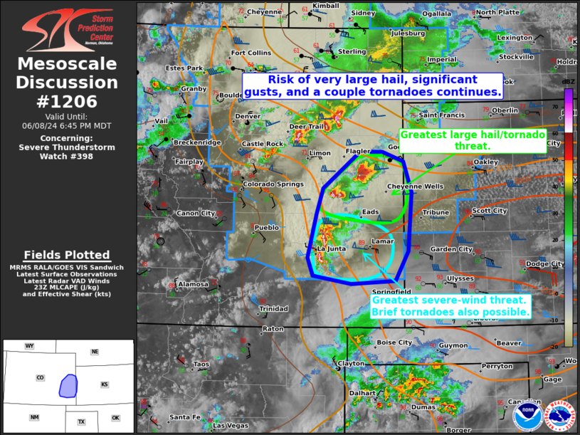
   Mesoscale Discussion 1206
   NWS Storm Prediction Center Norman OK
   0620 PM CDT Sat Jun 08 2024

   Areas affected...Portions of southeast and east-central CO into far
   southwest/west-central KS

   Concerning...Severe Thunderstorm Watch 398...

   Valid 082320Z - 090045Z

   The severe weather threat for Severe Thunderstorm Watch 398
   continues.

   SUMMARY...Risk of very large hail (up to 2.75 inches), significant
   gusts (70-80 mph), and a couple tornadoes continues across parts of
   Severe Thunderstorm Watch 398.

   DISCUSSION...Latest radar data from KGLD/KPUX depicts a pair of
   intense discrete supercells tracking generally east/southeastward at
   around 20 kt over Kit Carson, Cheyenne, and Lincoln Counties in
   east-central CO. A tornado and baseball-sized hail has been reported
   with the northern/eastern supercell. These storms are in a very
   favorable environment for the maintenance of supercells, with
   moist/backed easterly surface winds (lower 60s dewpoints) beneath a
   belt of 40-50-kt midlevel westerlies (per regional VWP).
   Additionally, ample clockwise low-level hodograph curvature (around
   250 m2/s2 effective SRH) should support continued strong
   low/midlevel mesocyclones given the seperated/discrete mode. As a
   result, very large hail (up to 2.75 inches) and a couple tornadoes
   are the main concern with these storms, with locally damaging gusts
   also probable.

   Farther south over Otero and Bent Counties in southeastern CO, an
   intense line segment has evolved in a moderately unstable air mass.
   40 kt of effective shear orthogonal to the line and a
   moist/well-mixed boundary layer should support the maintenance or
   even intensification of these storms as they continue eastward.
   Significant gusts of 70-80 mph could accompany this activity. A
   brief mesovortex tornado or two is also possible with these storms,
   given the ample low-level SRH described above.

   ..Weinman.. 06/08/2024

   ...Please see www.spc.noaa.gov for graphic product...

   ATTN...WFO...DDC...GLD...PUB...BOU...

   LAT...LON   38860341 39350279 39340241 39210205 38810190 38020196
               37610219 37580294 37690359 37920368 38510352 38860341
|
|
Top/All Mesoscale Discussions/Forecast Products/Home
|
|


 @NWSSPC