Mesoscale Discussion 1423
NWS Storm Prediction Center Norman OK
0335 AM CDT Wed Jun 26 2024
Areas affected...East-Central/Southeast KS...Far Northeast
OK...Southwest MO...Far Northwest AR
Concerning...Severe Thunderstorm Watch 461...462...
Valid 260835Z - 261000Z
The severe weather threat for Severe Thunderstorm Watch 461, 462
continues.
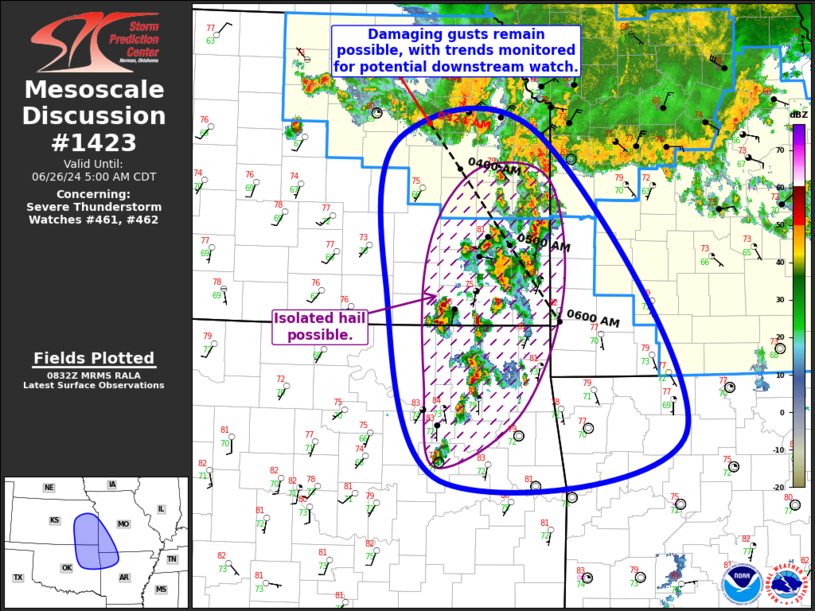
SUMMARY...Damaging gusts remain possible across east-central KS and
west-central MO. Additional severe potential may extend south into
portions of southeast KS, far southwest MO, far northeast OK, and
far northwest AR, and trends are being monitored for a possible
watch.
DISCUSSION...Complex convective evolution is underway across eastern
KS as a southeastward-progressing convective line begins to interact
with a more southward-progressing line ahead of it. This
southward-progressing line is also interacting with more cellular,
warm-air advection thunderstorms that extend from east-central KS
into far northeast OK. The quickest forward motion exists with the
southeastward-progressing line over northeast KS, and the general
expectation is for this line to remain dominant as it continues
southeastward, with perhaps a shift to a more southerly motion once
it encounters the warm-air advection responsible for the
east-central/southeast KS cellular development. However, strong
updrafts exist in the Kansas City vicinity (along the western edge
of the southward-progressing line), and there is some potential this
portion begins to surge southward as it interacts with the warm-air
advection to its south.
In either case, portions of southeast KS, far southwest MO, far
northeast OK, and far northwest AR may eventually be impacted by
whatever evolves. As a result, convective trends are being monitored
for a potential watch. Until this line arrives, isolated hail is
possible within the more cellular storms across the region.
..Mosier/Edwards.. 06/26/2024
...Please see www.spc.noaa.gov for graphic product...
ATTN...WFO...LZK...SGF...EAX...TSA...TOP...ICT...
LAT...LON 38829645 38839473 35949299 35489593 37439662 38829645
|


 @NWSSPC